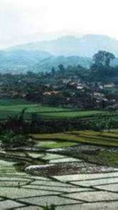
The
soil in Bandung Regency is relatively fertile, as the result of Java sedimentation
weathering, breks-itufa, and volcanoes arreas is in the form of preserved forests,
recreational forests, plantations (tea and quinine) Whereas areas around foot of montains
are used to cultivate horticultural plants (especially vegetables), tea plantations and
mixed estates. |
The
area of the Regency of Bandung is a mountainous area, located between 107022
10805 east longitude and 604 7019
south longitude, with an elevation of 110 meter up to 2.429 meter on seas surface. |
This
area has a tropical climate, which has some influences of mountainous range climate with
humid and cool air. The average daily temperature in lower area is ranges between 300
Celsius, and in higher area between 150 until 180 Celsius.
|
The
width of the regency of Bandung area is about 309.20793 Ha, with the borders as follows : |
|
1. Northern sight. Adjacent to the regency of |
|
Purwakarta and the regency of Subang. |
|
2. West sight. Adjacent to the regency of Garut. |
|
3. South sight. Adjacent to the regency of Garut |
|
and the regency of Cianjur. |
|
4. East sight. Adjacent to the regency of Sumedang. |
This
area is surrounded by mountainous areas, such as; Malabar Mountain, Tangkubanparahu
Mountain, Bukittunggul Mountain, Manglayang mountain, Papandayan Mountain, and Patuha
Mountain. This natural situation, makes it possible for many rivers to flow through this
area, such as; Citarum river, Cisangkuy river, and the other rivers which are very
important for agriculture and a rich source of energy, and making use for Saguling and
Cirata dam. |
 |
The
regency of Bandung is surrounding the municipality the capital of West Java, Bandung City,
as the center of the government of West Java. Accordingly, it becomes an important
supporting area to the capital of West Java. This special position of this area makes it
important and strategic, either in development of economy and infrastructure or in
security. |
This specific condition, in return, gives a specific function to the regency of Bandung
and give motivation and demand in its development effort and achieving the
goal of Autonomy Pilot Project in the regency of Bandung in particular and Indonesia
tourism in general. |
Regency
of Bandung constitutes a basin in Bandung plateau which morphologically consists of flat
and mountainous areas. The inclination of the slopes varies from 0.8%, 2-15 to over 45 %. |
There
are 172 rivers in Bandung Regency, 30-40% of which have water all year long, such as
Citarum and Cisangkuy which are exploited for several purposes the irrigation, Drinking
Water Resource and Hydroelectric Power Station. |
Infrastructures
and facilities available as the outcome of the first long term development also contribute
to the succes of the development of transportation infrastructures also supports the
economic growth rate in Bandung Regency. Until 1996 the transportation infrastructure in
Bandung regency included state road as long as 59,935 km, provincial road 173.110 km,
regency road 339.032 km and village road 714.776 km. The infrastructure which connect a
sub district city and villages are in good condition and be passed through by cars and
motorcycles. |
|