The Junction(click to listen)          © 2013, Natty Bumppo


           lyrics and chords  (in A minor):

a I was born in G Eighty a Eight,
And C I grew up in G Eighty a Eight,
And C I took Ninety, G you’re damn a straight,
All the way, to G Sixty a Eight,
      And G Eighty.
 
They part in Metcalfe, up the road; there
F One heads north, or so I'm told; but
G I went west, with a heavy load,
F On to Happy Valley Road,
      In G Glasgow.
 
My Dad's from Sideview, Tennessee;
And he told me, most carefully,
That Eighty Eight’s not where to be,
That Allen County was for me
      And Whitney.


That's where he met his bride-to-be,
My mama and her family;
They lived there most primitively,
Near the parting of the sea,
      The Junction.
 
It’s known as Highway One O One,
And Two Three Four, they’re all in one;
It must be where it all begun
And Eighty Eight could come undone at
      The Junction.
 
So say good-bye to Eighty Eight
Before it gets to be too late,
Do not trust your life to fate,
Take control and bear the weight:
      It’s easy.
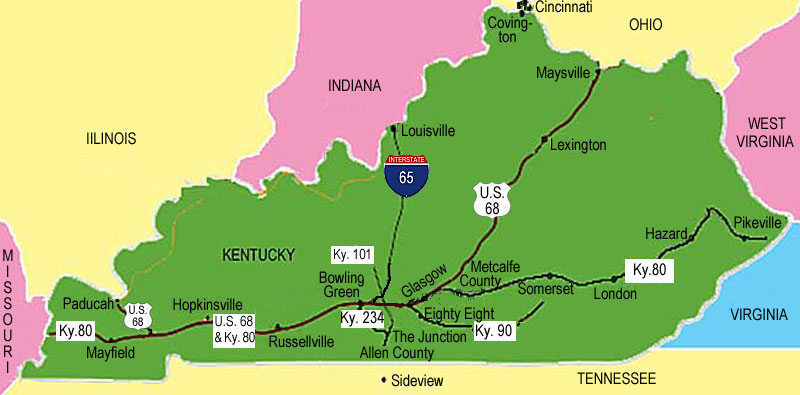


For those not from around here, a little explanation is necessary.  Eighty Eight is a town in Barren County,
Kentucky,  8.8 miles southeast of Glasgow, the county seat, on Highway 90,  and 88 miles south of Valley
Station,  the southernmost suburb of Louisville  –  not named, however, for its location, it is said,  but so
named when its first postmaster, in the middle of the 19th century, pulled 88 cents out of his pocket.

When you take Highway 90 in to Glasgow,  you'll wind up on Happy Valley Road;  but first you'll cross
68 and 80 – that's U.S. 68 (the only federal highway number in this song) and Ky. 80.   Highways 68 and
80 (“68 'n' 80, ” they say) run together through most of western and central Kentucky;  but  in  Metcalfe
County,  adjacent to Barren County on the east,  they split,  U.S. 68 heading northeast to Lexington and
Maysville,  and Ky. 80 going on east to Appalachia.


There really is a town called Sideview in northern Tennessee, on U.S. Highway 31-E.  Scottsville, the coun-
ty seat of Allen County, Kentucky, and Glasgow also lie on 31-E.  Allen County lies on the southwest side
of Barren County.
Whitney, of course, is my nickname for the chick singer I've been teaming up with.
But the most efficient way to get to the part of Allen County in this song, from Glasgow and Happy Valley
Road, is not by 31-E southwest toward Scottsville, but to go back to 68 & 80 and take them west-northwest
through a snippet of Warren County to Highway 101 (which was the name of a popular country music group
in the 1980's and '90's),  just south of Smiths Grove,  and then head south on 101.


Whitney and her husband have a farm on Highway 101 in northern Allen County; and just two miles south of
their farm, and six miles north of Scottsville, lies the remarkable junction (this, too, has been in Tabloid Head-
lines):  Highways 101 and 234 – “where it all begun” (yeah, yeah, Connie, I know, it should be began, but it has
to rhyme).


“Brownstown”  –  my town,  in Edmonson County  –  would lie on 101 also.   But just four miles southeast of
Brownsville, at a town called Rhoda (there really is such a place – it’s pronounced “roady”), Highway 101 runs
into Highway 259; and only 259 gets the credit for the rest of the road to Brownstown.  Most people in Edmon-
son County don’t know this; they think Highway 101 goes all the way to Brownsville.  (I even got a plat from a
surveyor, from Barren County, who did not know this.  The plat showed a lot lying on Highway 101, but it didn’t
– it lay on Highway 259.)  Rhoda and Scottsville are the north and south termini,  respectively,  of Highway 101,
which runs not quite 30 miles altogether, as the worm turns.


The most fun in the song (aside from the two-word tags at the end of each stanza and chorus) is the word
“primitively” in the second chorus:  To get it right metrically, you have to accent both the first syllable and
the third syllable:  PRIM-i-TIVE-ly.


Catherine Scott wrote from Versailles, Ky., Sun 4/7/13 @14:24 EDT:

And then theres the fact that locals refer to these roads by name, not number.  Maybe thats another
song.
Or by whatever name they choose.  Highway 90 is East Main Street on one side of Glasgow,
Happy Valley Road on the other.  It’s probably called “Glasgow Road” in Eighty Eight, but I don’t know.


Highway 101 is known as Chalybeate (that’s pronounced “kah-LEE-be-ut”) Road in Edmonson County and as
Smiths Grove Road in Warren and Allen counties.  Highways 68 ’n’ 80 are known as Adams Street and Kentucky
Street in the heart of Bowling Green (depends on which direction you're going; they’re both one-way streets)
and Russellville Road farther south.


And, then, they change the names of the roads.  A friend and client of mine died the last time they changed the
names here in the County.  She had a stroke; and her family called the ambulance and gave the correct new ad-
dress, on “T. Lindsey Road,” formerly the “Larry Davis Road.”  But the dispatcher heardP. Lindsey Road,”
which is on the other side of the County; and that’s where the ambulance went.  Shirley finally got to the hospital,
but not on time.


My place is on Willie Webb road.  That’s because Willie now lives in town.  It was Dit Webb Road when I moved
here, when Willie lived down the road.  Dit, Willie’s father, is now deceased.  Willie’s son, A. B. (for Albert Benjamin,
as in Happy Chandler) Webb, lives there now.  When Willie dies and A. B. moves to town, it will be A. B. Webb Rd.
Thank God fer them Webbs!  Keep ’em comin’!  If they died out, it would be Bumppo Road.  (A.B. does have children.)

There's yer ’nother song or, at least, the beginning of it. . . .

Catherine Scott wrote Sun 4/7/13 @15:25 EDT:

Highway 90 going toward Eighty Eight from Glasgow is the “Burkesville Road.”  Don't know what it might
be going in the other direction, maybe the same.  Then there is the ever popular direction given by landmark.
Around here it tends to be something like, “Go to the old K-Mart store,” or “the old Kroger.”  You have to
know that the old K-Mart is now a flea market gone belly up.  The old Kroger is now a Save-A-Lot.  Ya gotta
love Kentucky.


Don’t have to!


But it’s the same all over (hey! There’s a Canned Heat song!) – probably even in turKeY.

Highway 259 is Brownsville Road in Edmonson County.  So, there’s a new problem!  Depends on which way you are
going, as you suggested for Eighty Eight.  To get to Chalybeate from Brownsville, you have to take Brownsville Road
to Rhoda and then, following your nose, continue on Chalybeate Road instead of taking a left turn to follow Brownsville
Road.  But once you pass Rhoda, you're already in Chalybeate.  Or were you on Chalybeate Road the whole time?  Chaly-
beate Road is not (or is) to be confused with Chalybeate School Road, which runs (like Browns­ville Road, once you get t
 Rhoda) perpendicular to Chalybeate Road.


TedF wrote Tues 4/9/13 @08:35 CDT:

Your song needs action – love, lust, murder, hate, or all four – some kind of dysfunction, malfunction. or “some-
thin’ at the junction” with the three characters (me, mom and pop) or some other character.  Maybe cut the 88 in
half and bring in two .44’s . . . .


Eighty Eight, an unincorporated municipality,  is said to have a population of 259.  There's a town in southwestern Penn-
sylvania called Eighty Four with population 483.