Abandoned & Little-Known Airfields:
Florida, Northern Pensacola area
© 2002, © 2016 by Paul Freeman. Revised 4/1/16.
This site covers airfields in all 50 states: Click here for the site's main menu.
____________________________________________________
Please consider a financial contribution to support the continued growth & operation of this site.
Bell's Field NOLF (revised 4/1/16) - Clay Pits NOLF (revised 1/1/05) - German's Field NOLF (revised 11/1/15)
Gonzalez NOLF (revised 12/30/13) - Lyons NOLF (added 4/27/13) - Olive Naval Outlying Landing Field / Site 4A (revised 11/1/15)
Stump Field NOLF (revised 7/8/14) - Y Field NOLF / Field 35307 (revised 4/1/16) - Z Field NOLF (revised 6/13/12)
____________________________________________________
Olive Naval Outlying Landing Field / Site 4A, Olive, FL
30.53 North / 87.25 West (North of Pensacola, FL)

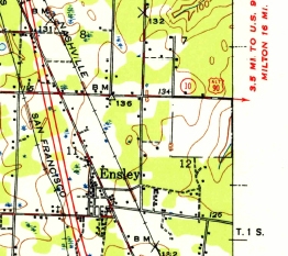
The 1941 USGS topo map (courtesy of Dallam Oliver-Lee) depicted the square-shaped clearing of Olive Field, but did not label the airfield.
According to Brian Rehwinkel, “Site 4A (Bureau of Aeronautics # 00313) was a pre-war auxiliary landing field (outlying field) acquired by the Navy in late 1939.
The approximately 157 acre sod field was not developed for use until later in 1940 for use by training planes from NAS Pensacola.”
The earliest depiction which has been located of Olive Field was on the 1941 USGS topo map (courtesy of Dallam Oliver-Lee).
It depicted the square-shaped clearing of Olive Field, but did not label the airfield.
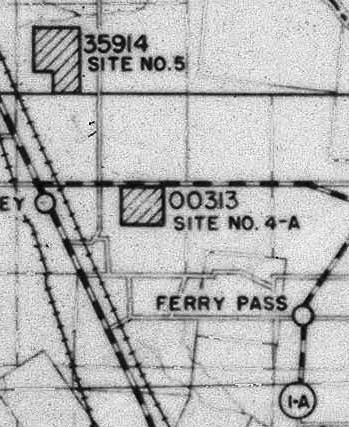
A 6/30/42 map of NAS Pensacola & its satellite fields (courtesy of Brian Rehwinkel)
depicted "00313, Site No. 4-A" as a square outline.
According to Brian Rehwinkel, “Although the airfield was very close (approximately 3 miles) to NAAS Ellyson Field,
the OLF apparently was assigned to NAS Pensacola (Naval Air Training Center) for most of World War Two.”
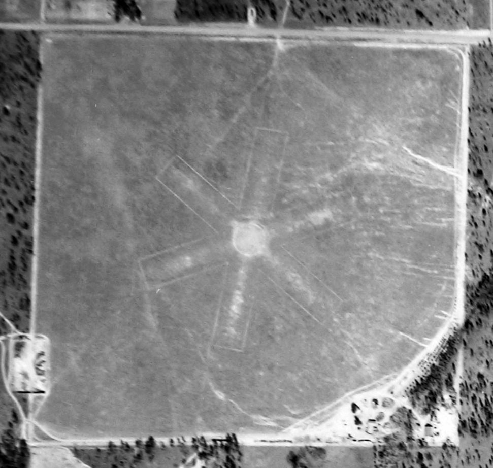
The earliest photo which has been located of Olive Field was a 3/5/43 National Archive aerial view (courtesy of Brian Rehwinkel).
Brian observed, “The WWII configuration had an asterisk-shaped landing pattern.”
Topo maps from 1943 & 1944 depicted depicted the square-shaped clearing of Olive Field, but did not label the airfield..
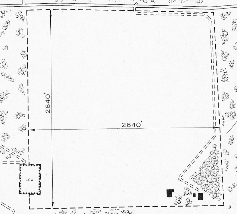
The 1945 USAAF Directory/Continental United States (courtesy of Brian Rehwinkel)
described “Pensacola Naval Air Station Auxiliary (00313 Outlying Field No. 4A)”
as a 160 acre square turf field measuring 2,640' each way.
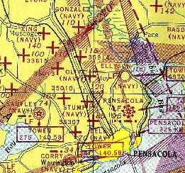
The earliest aeronautical chart depiction which has been located of Olive Field was on the 1945 Mobile Sectional Chart.
It depicted “Olive (Navy)” as an auxiliary airfield, surrounded by the amazingly dense wartime assemblage of Pensacola-area Navy airfields.
Brian Rehwinkel observed, “Site 4A OLF was later used by helicopters from Ellyson Field.”
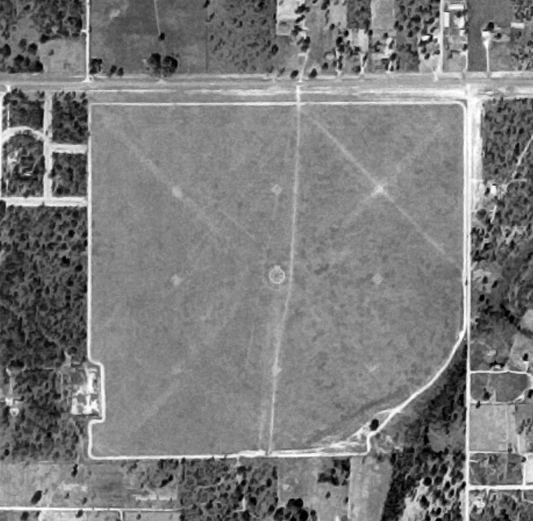
The earliest photo which has been located of Olive Field was a 10/22/55 aerial view (courtesy of Dallam Oliver-Lee).
It depicted Olive as being a square-shaped grass field (with a cutout at the southeast corner).
Brian Rehwinkel observed, “You can still see the same [asterix-shaped] markings [as seen in the 1943 photo] if you look carefully.
The more prominent markings on the field are for helicopter training.”
Olive Field may have been abandoned by the Navy as an airfield at some point between 1945-57,
as it was no longer depicted among other Pensacola-area Navy outlying fields on the 1957 USGS topo map (courtesy of Dallam Oliver-Lee).
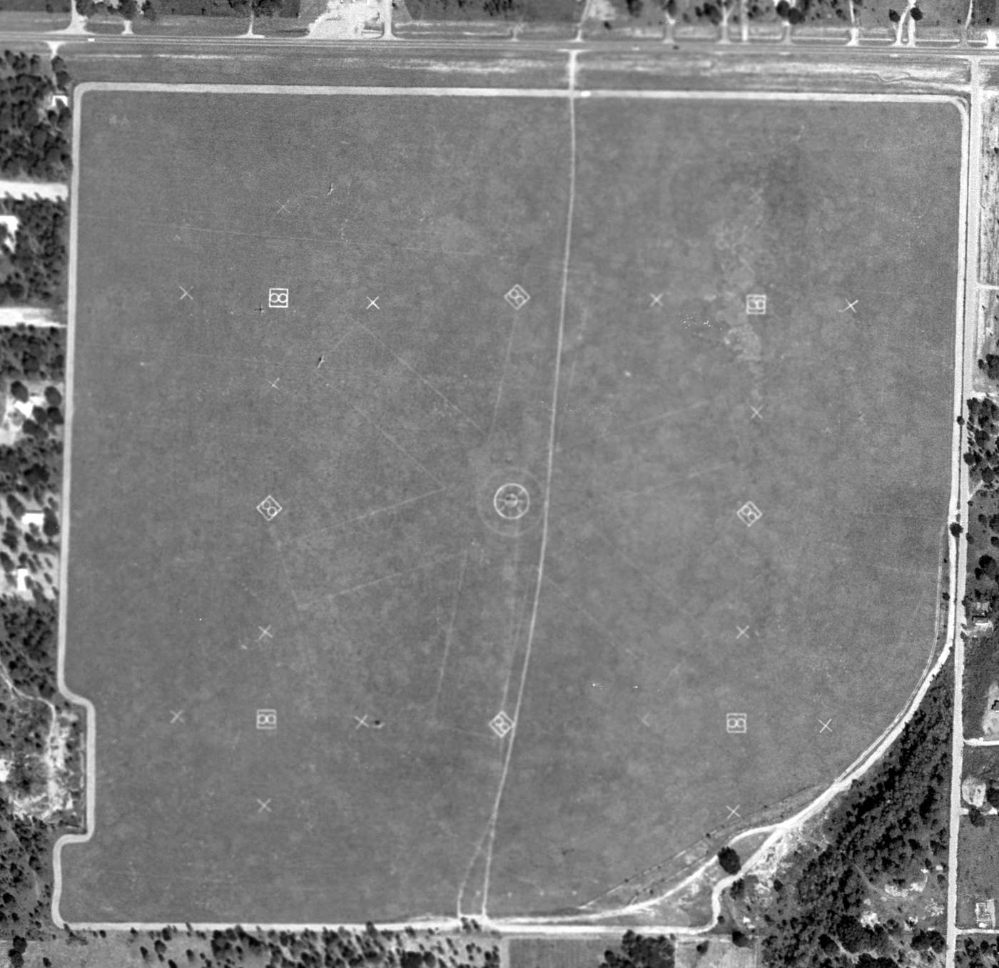
A 10/21/61 FLDOT aerial view (courtesy of Dallam Oliver-Lee) still showed the runway & helicopter markings on Olive Field.
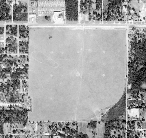
The last photo which has been located appearing to still show Olive Field intact was a 2/10/74 aerial view (courtesy of Dallam Oliver-Lee).
The field appeared largely unchanged from the 1955 photo.
According to Brian Rehwinkel, “When helicopter training moved to NAS Whiting Field in the early 1970s, Site 4A was probably not needed any longer.”
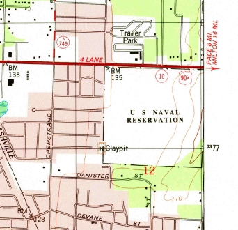
The 1978 USGS topo map (courtesy of Dallam Oliver-Lee) labeled the Olive Field site as “US Naval Reservation”.
According to Brian Rehwinkel, “A November 1979 aerial photo indicates that the field was abandoned.
By this time, Site 4A was surrounded by housing & was less suitable for use as an airfield.”
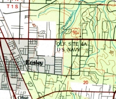
The 1981 USGS topo map (courtesy of Dallam Oliver-Lee) labeled the Olive Field site as “OLF Site 4A US Navy”.
According to Brian Rehwinkel, “Eventually, the land was acquired by local governmental agencies.”
A 1994 USGS aerial view (courtesy of Dallam Oliver-Lee)
showed that baseball fields were being developed on the property adjacent to the east side of Olive Field.
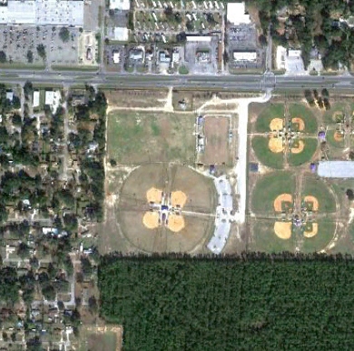
A 1/3/12 aerial view (courtesy of Dallam Oliver-Lee) showed that baseball fields covered the southern portion of the Olive Field site.
As of 2013 the site of Olive Field is occupied by Drummond Park.
The site of Olive Field is located southwest of the intersection of East 9 Mile Road & Airway Drive.
____________________________________________________
Gonzalez Naval Outlying Landing Field, Gonzalez, FL
30.6 North / 87.27 West (North of Pensacola, FL)
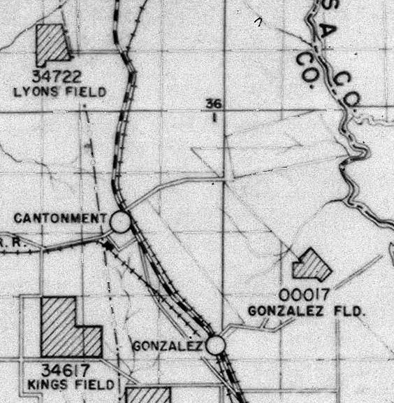
“00017 Gonzalez Field”, as depicted on a 1942 map of Pensacola-area Navy airfields (courtesy of Brian Rehwinkel).
Gonzalez Field was one of the amazing number of auxiliary fields which were established by the Navy
to support flight training operations at Naval Air Station Pensacola.
According to Brian Rehwinkel, “Gonzalez OLF (Bureau of Aeronautics # 00017) was acquired (for $1,791)
just before the beginning of World War Two – in mid-October 1941.
Most likely, the field was not used until later in 1941 or early 1942.
The Navy acquired 116 acres for this grass airfield.
As with Site 4A, Gonzalez OLF was assigned to NAS Pensacola (and later the Naval Air Training Center) for most of World War Two.
Gonzalez was a small airfield and was used for 'small field training' purposes.”
The earliest depiction which has been located of Gonzalez Field was on a 1942 map of Pensacola-area Navy airfields (courtesy of Brian Rehwinkel),
which depicted “00017 Gonzalez Field” as an irregularly-shaped outline.
According to Brian Rehwinkel, “A March 1943 memo states that Gonzalez OLF was being used for emergency landings only at that time.
Because of its small size & distance from the main station & auxiliaries, it was probably not used much.”
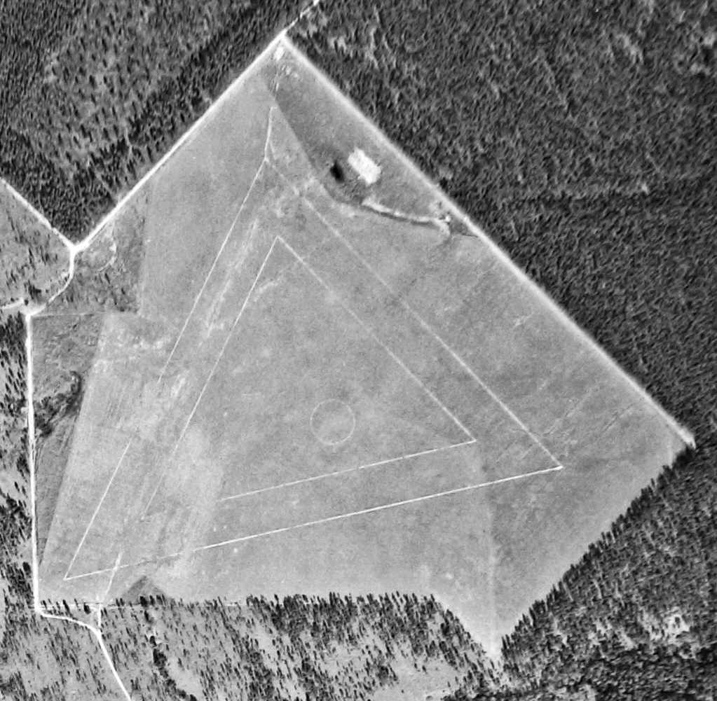
The earliest photo which has been located of Gonzalez Field was a 1943 National Archives aerial view (courtesy of Brian Rehwinkel).
It depicted a triangular set of runways marked out on a grass airfield.
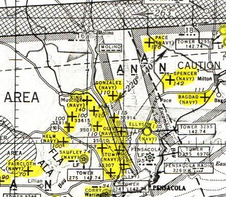
The earliest aeronautical chart depiction which has been located of Gonzalez Field
was on the 1945 Mobile Sectional Chart (courtesy of John Voss).
It depicted “Gonzalez (Navy)” as an auxiliary airfield.
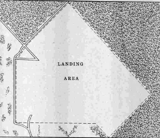
The 1945 AAF Airfield Directory (courtesy of Scott Murdock) described “Pensacola Naval Air Station Auxiliary (00017 Gonzalez Outlying Field)”
as a 80 acre irregularly-shaped property having a turf all-way landing area measuring 2,640' northwest/southeast.
The field was not said to have any hangars, to be owned by the U.S. Government, and operated by the Navy.
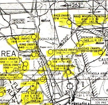
The last aeronautical chart depiction which has been located of Gonzalez NOLF was on the 1949 Mobile Sectional Chart.
“Gonzalez (Navy)” was depicted as having a 2,600' unpaved runway.
According to Brian Rehwinkel, “I don’t know how much Gonzalez was used after the war. It is likely the site was not used much.
It doesn’t show up on a list of OLFs for the Pensacola area in the early 1950s (even though it was still owned by the Navy at that time).”
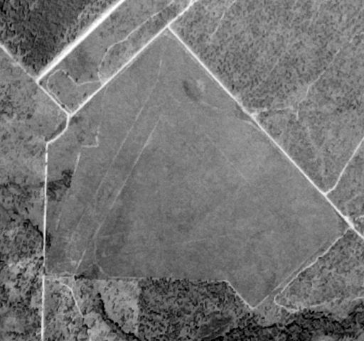
A 10/22/55 aerial view (courtesy of Dallam Oliver-Lee)
depicted Gonzalez Field as an irregularly-shaped grass field,
with the very faint traces of 3 runways marked on the field.
According to Brian Rehwinkel, “Gonzalez was declared surplus by the Navy in 1955 & sold in July 1956 to private individuals.
As part of the sale (by the General Services Administration), the Navy imposed a flight restriction clause for this property because of possible conflict with training traffic.”
Gonzalez Field was no longer depicted on the 1957 USGS topo map.
According to Brian Rehwinkel, “The new owners requested a removal of the [flight] restriction in 1958, but the Navy apparently rejected the request.”
A 2008 aerial photo (courtesy of Dallam Oliver-Lee) still showed the site of Gonzalez Field to remain an open, undeveloped plot.
A 2009 aerial photo (courtesy of Dallam Oliver-Lee) showed what appeared to be a water treatment plant
having been built over the northern portion of the Gonzalez Field site.
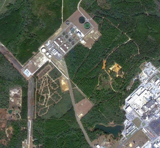
A 1/3/12 aerial view (courtesy of Dallam Oliver-Lee) showed that the outline of Gonzalez Field was still recognizable.
Brian Rehwinkel remarked in 2013, “The airfield is apparently the site of a spray field for Escambia County’s newly-relocated sewage treatment plant.”
The site of Gonzalez Field is located north of the intersection of New Haven Road & Old Chemstrand Road.
____________________________________________________
Lyons Naval Outlying Landing Field, Cantonment, FL
30.65 North / 87.34 West (North of Pensacola, FL)
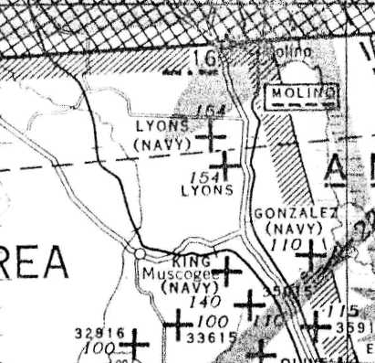
Inexplicably, a 1940s Mobile Sectional Chart depicted 2 nearby auxiliary airfields, both labeled “Lyons”.
Lyons Field was one of the amazing number of auxiliary fields which were established by the Navy
to support flight training operations at Naval Air Station Pensacola.
Lyons Field was evidently established at some point between 1941-49,
as it was not yet depicted on a 3/25/41 USDA aerial view (courtesy of Dallam Oliver-Lee),
the 1943 USGS topo map,
nor the 1945 Mobile Sectional Chart (courtesy of John Voss).
The earliest depiction of Lyons Field which has been located was on a circa 1940s Mobile Sectional Chart.
Inexplicably, the Sectional depicted 2 nearby auxiliary airfields, both labeled “Lyons”.
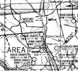
The last aeronautical chart depiction which has been located of Lyons NOLF was on the 1949 Mobile Sectional Chart.
Compared to the earlier chart, it only depicted the more-southern of the 2 Lyons fields.
“Lyons (Navy)” was depicted as having a 4,000' unpaved runway.
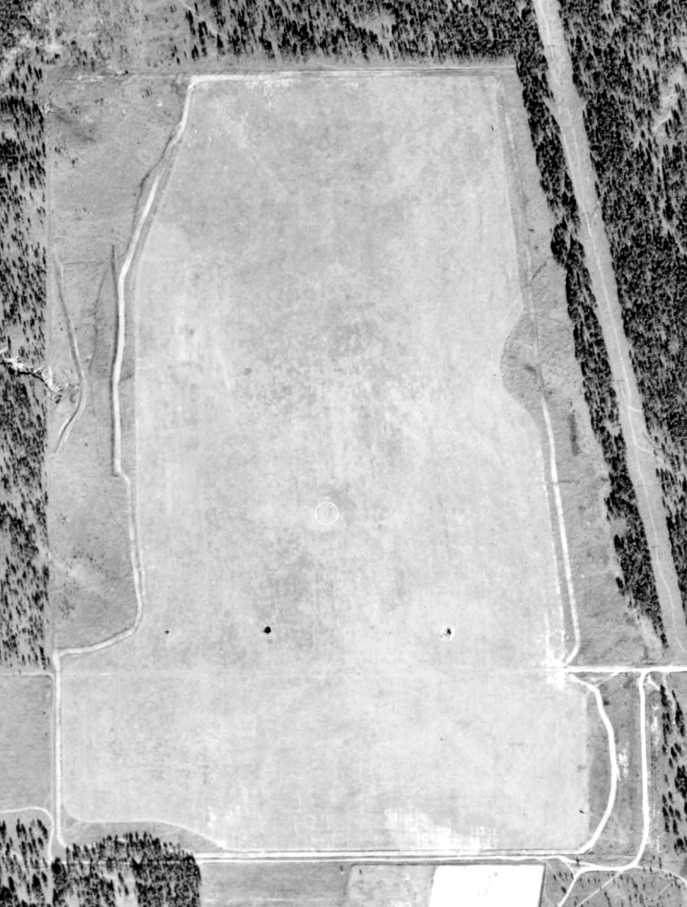
The earliest photo of Lyons Field which has been located
was a 1/4/51 USDA aerial view (courtesy of Dallam Oliver-Lee).
It depicted Lyons Field as an irregularly-shaped grass field,
with an airfield circle marking in the center.
A 10/22/55 USDA aerial view (courtesy of Dallam Oliver-Lee)
depicted several runways laid out along Lyons Field.
Lyons Field was not yet depicted on the 1956 USGS topo map.
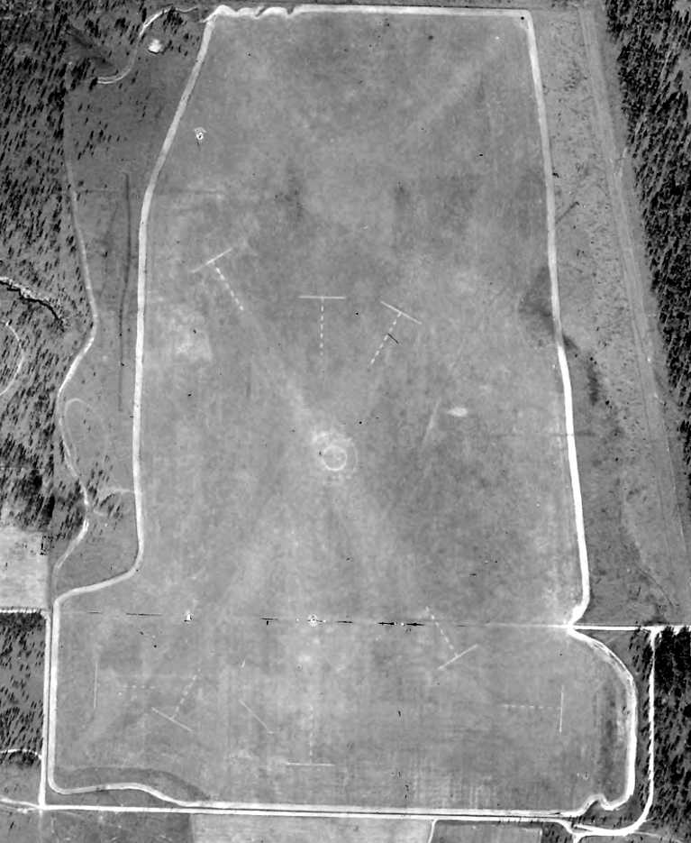
The last photo which has been located which appears to still show Lyons Field in use
was a 1/3/58 USDA aerial view (courtesy of Dallam Oliver-Lee).
Markings for 3 runways were prominent on the field.
Lyons Field was evidently abandoned by the Navy at some point between 1958-64,
as it was no longer depicted on the 1964 Mobile Sectional Chart.
A 2/10/74 USDA aerial view (courtesy of Dallam Oliver-Lee) showed the field reused for farming.
A 12/25/95 USGS aerial view (courtesy of Dallam Oliver-Lee)
still showed the field reused for farming.
An 11/30/04 aerial view (courtesy of Dallam Oliver-Lee)
showed 3 ponds having been constructed on the west side of the field.
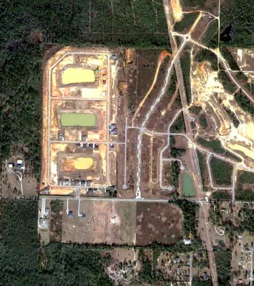
A 1/3/12 aerial view (courtesy of Dallam Oliver-Lee) showed that the outline of Lyons Field was still recognizable,
but housing was being built over the former airfield.
The site of Lyons Field is located north of the intersection of West Quintette Road & Meeting Street.
____________________________________________________
Y Field Naval Outlying Landing Field / Field 35307, Pensacola, FL
30.443, -87.28 (West of Pensacola Regional Airport, FL)
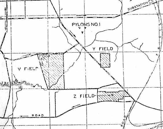
"Y Field", as depicted on a 1939 map of NAS Pensacola & its satellite fields (courtesy of Brian Rehwinkel).
Y Field was one of the large number of auxiliary fields which were established by the Navy
in the late 1930s to support flight training operations at the Pensacola Flight School.
Brian Rehwinkel reported, “According to a February 1935 Navy memo,
Y Field was being used at that time for 'instruction & check in small field precision landing.'
This suggests the use of this field began in 1934 or earlier, although the use may not have been through a formal lease.
Navy records indicate the field was first formally leased in July 1937 for use as an outlying field.
At the time, the lease was for a 60-acre tract, and of those 60 acres,
only a portion of that was cleared and used for landings & takeoffs.”
Y Field was not listed in The Airport Directory Company's 1937 Airports Directory (courtesy of Bob Rambo).
Brian Rehwinkel reported, “In 1939, the leased acreage was increased to 90 acres
and all of the leased area was cleared & prepared for use by training aircraft.”
The earliest depiction of Y Field which has been located
was on a 1939 map of NAS Pensacola & its satellite fields (courtesy of Brian Rehwinkel).
It depicted Y Field simply as a rectangular area,
and it was extremely small for a Navy airfield, even for an auxiliary field in the 1930s.
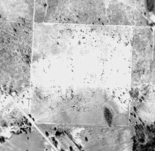
A 1941 USDA aerial view of Y Field,
from the Digital Library Center / University of Florida George A. Smathers Libraries (courtesy of Brian Rehwinkel).
The airfield consisted of a very small rectangular grass area,
and there did not appear to be any buildings or other aviation facilities associated with the field.
The 1941 USGS topo map (courtesy of Dallam Oliver-Lee) & 1943 USGS topo map (courtesy of Dallam Oliver-Lee)
depicted Y Field as an empty unlabeled rectangular area.
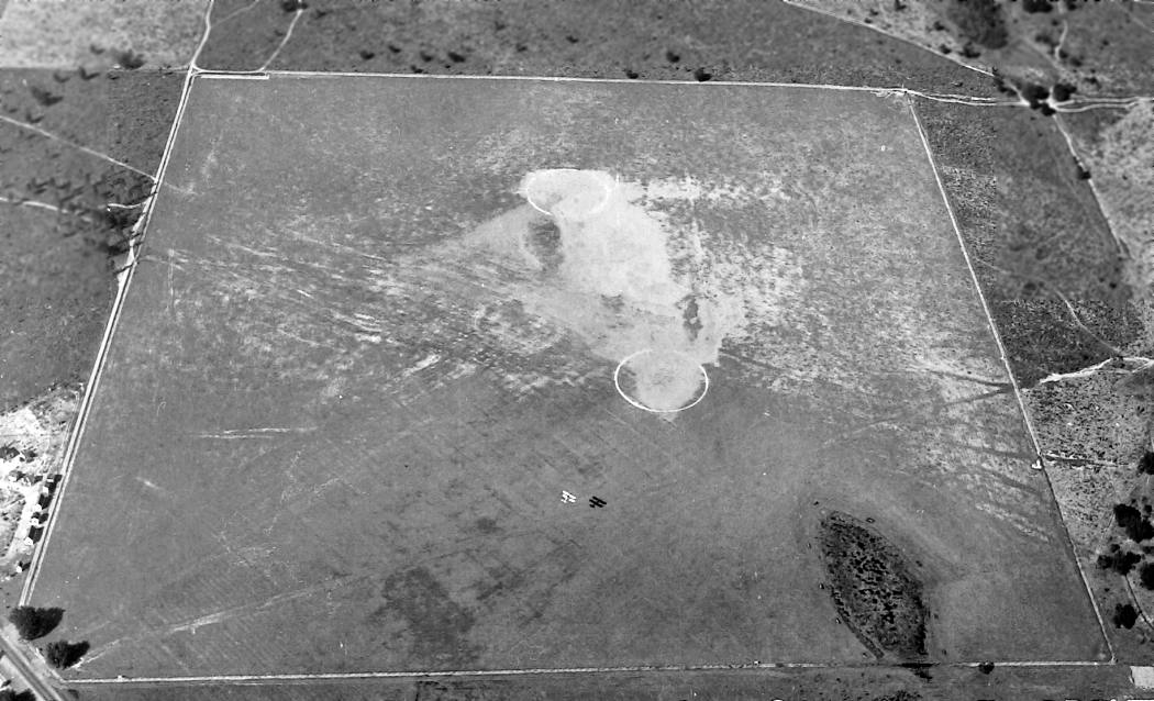
The only photo which has been located showing Y Field in use was a 2/16/43 U.S. Navy aerial view looking north (National Archives, via Brian Rehwinkel),
showing a biplane flying low over the field.

The 1944 USGS topo map depicted Y Field (at the top-right) as a square unpaved landing area, labeled as “Landing Field”.
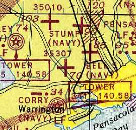
By 1945, Y Field had apparently been renamed as Field "35307",
as that is how it was labeled on the February 1945 Mobile Sectional Chart (courtesy of Chris Kennedy).
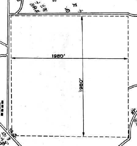
The 1945 AAF Airfield Directory (courtesy of Scott Murdock) described “Corry Field Auxiliary (35307 Y Outlying Field)”
as a 90 acre squared-shaped property having a 1,980' square turf all-way landing area.
The field was not said to have any hangars, to be owned by private interests, and operated by the Navy.
Robert Cooper recalled, “I bought my first airplane at Y Field, a BT-13 that had belonged to a flight student.”
Brian Rehwinkel reported, “The field was used until 1945, at which time the lease was allowed to expire.
The lease for the field does not show up on a 1946 list of leases for the Naval Air Training Bases, Pensacola.
By that time, such a small sod field - about 1,980 feet square - was only suitable for use as an emergency field.”
Y Field / Field 35307 was no longer depicted at all on the 1949 Mobile Sectional Chart (courtesy of John Voss).
A 1951 aerial view showed the field remained intact, but showed no sign of any recent aviation use.
A 10/22/55 USGS aerial photo (courtesy of Dallam Oliver-Lee) showed houses covering most of the Y Field property.
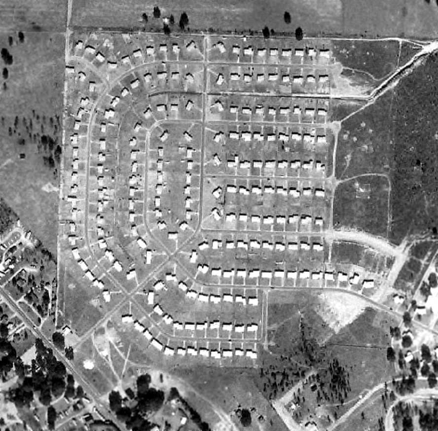
A 1/3/58 USDA aerial view of the site of Y Field,
from the Digital Library Center / University of Florida George A. Smathers Libraries (courtesy of Brian Rehwinkel),
showing that housing had been built over the former airfield at some point between 1951-58.
The outline of the airfield was still very recognizable, though.
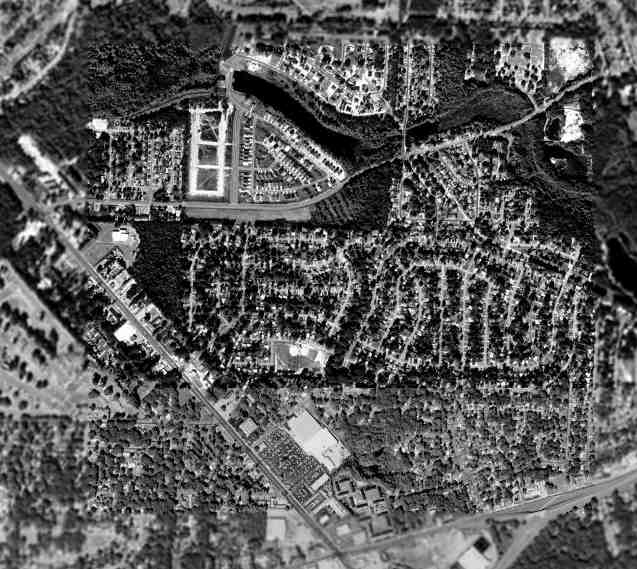
As seen in the 1999 USGS aerial photo of the site of Y Field,
the area has been extensively redeveloped with housing & other buildings,
and not a trace appears to remain of the former Navy airfield.
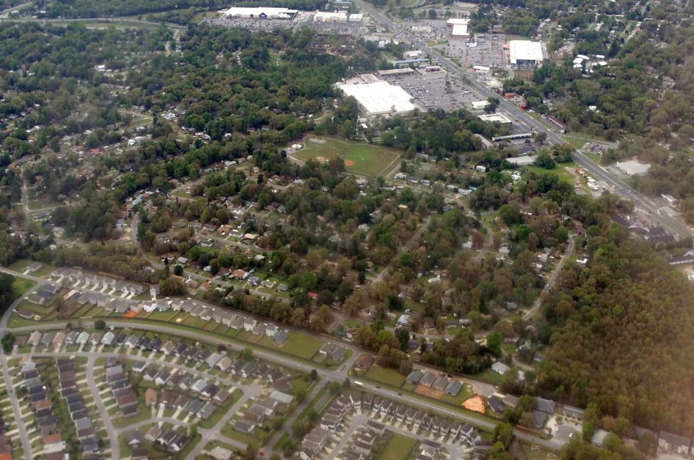
A 3/29/16 aerial view by Dallam Oliver-Lee looking south at the site of Y Field.
The site of Y Field is located north of the intersection of Route 90 & Wabash Avenue.
____________________________________________________
Z Field Naval Outlying Landing Field, Pensacola, FL
30.43 North / 87.28 West (Southwest of Pensacola Regional Airport, FL)
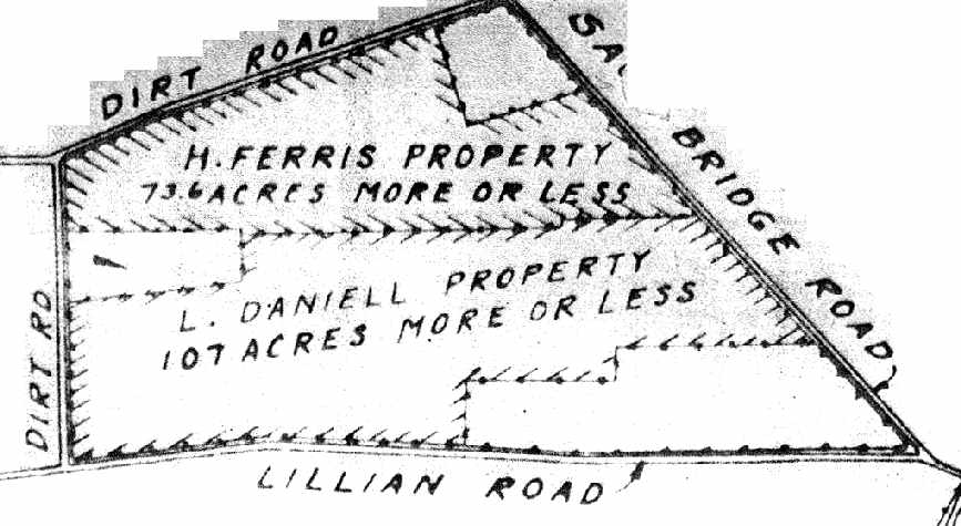
"Z Field", as depicted on a 1932 Navy plat of “Properties Comprising Z Field” (courtesy of Brian Rehwinkel).
Z Field was one of the large number of auxiliary fields which were established by the Navy
to support flight training operations at the Pensacola Flight School.
According to Brian Rehwinkel, the Navy began the process of leasing approximately 190 acres of land
(from three different land owners) for Z Field in late 1929.
The earliest depiction of Z Field which has been located
was on a 1932 Navy plat of “Properties Comprising Z Field” (courtesy of Brian Rehwinkel).
It indicated that 73 acres of the field were owned by H. Ferris,
and 107 acres were owned by L. Daniel.
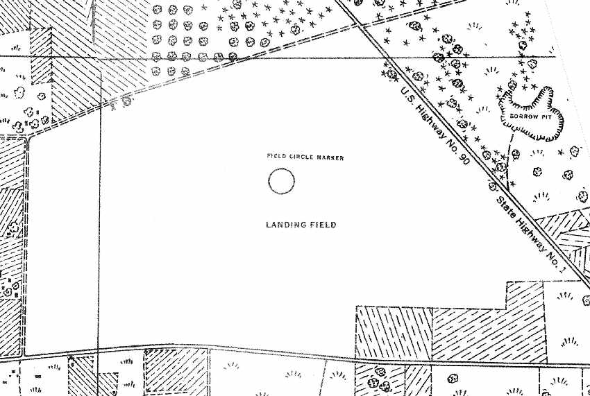
The 1934 USGS topo map (courtesy of Brian Rehwinkel)
depicted Z Field simply as a “Landing Field” with a “Field Circle Marker” in the middle.
No buildings or other airfield features were depicted.

"Z Field", as depicted on a 1939 map of NAS Pensacola & its satellite fields (courtesy of Brian Rehwinkel).
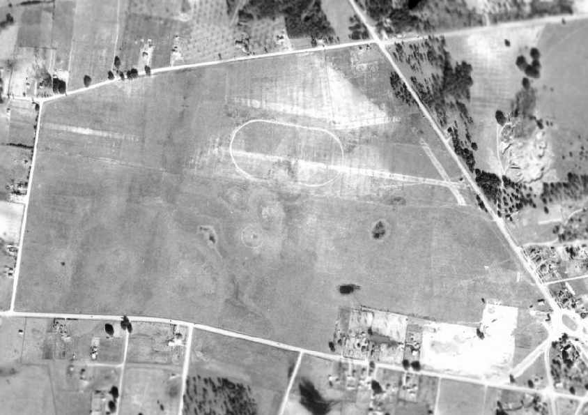
A 1/9/41 USDA aerial view of Z Field,
from the Digital Library Center / University of Florida George A. Smathers Libraries (courtesy of Brian Rehwinkel).
The airfield consisted of a large open grass area, within which were visible 5 runways.
There did not appear to be any buildings or other aviation facilities associated with the field.
According to Brian Rehwinkel, Z Field was apparently abandoned by the Navy at the beginning of World War Two.
The Navy apparently canceled the lease(s) sometime in 1941 or early 1942.
Z Field was no longer depicted on the 1941 USGS topo map,
a June 1942 map of Outlying Fields for NAS Pensacola, nor on the 1943 USGS topo map.
.

A possibly contradictory indication is offered as to the wartime use of Z Field by the 1944 USGS topo map,
which depicted a fairly complex airfield configuration of no less than 5 runways, labeled as “Landing Field (Under Construction)”.
Z Field was no longer listed in the April 1944 US Army/Navy Directory of Airfields (courtesy of Ken Mercer)
or depicted on the February 1945 Mobile Sectional Chart (courtesy of Chris Kennedy).
A 1951 aerial view showed that the majority of the former airfield remained clear,
although a drive-in theater had been built at some point between 1941-51 on the southeastern corner.
A 10/22/55 USGS aerial photo (courtesy of Dallam Oliver-Lee) showed that housing had covered the southern half of the property.
A 1958 aerial view showed that housing had covered the remainder of the field.
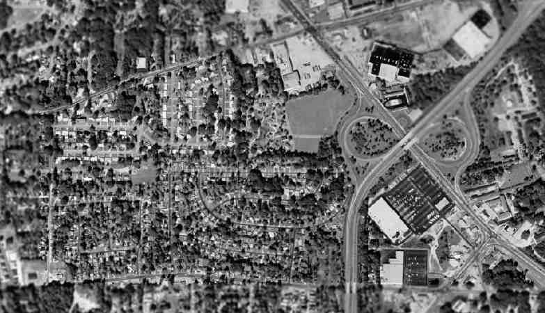
As seen in the 1999 USGS aerial photo of the site of Z Field,
Route 295 was constructed through the eastern portion of the site of Z Field,
which has otherwise been densely redeveloped with housing.
Not a trace appears to remain of the former Navy airfield.
The site of Z Field is located west of the intersection of Route 90 & Route 295.
____________________________________________________
Bell's Field Naval Outlying Landing Field, Pensacola, FL
30.45, -87.25 (Southwest of Pensacola Regional Airport, FL)
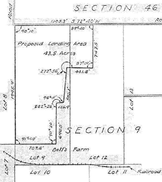
A February 19, 1935 plat plan of the "Proposed Landing Area" on Bell's Farm (courtesy of Brian Rehwinkel).
Bell’s Outlying Field was one of a number of auxiliary landing fields
which were established to support flight training in the Pensacola area.
The date of establishment of Bell's Field has not been determined.
It was not yet depicted on the 1934 Navy Aviation Chart V-242 (courtesy of Chris Kennedy).
The earliest depiction of Bell's Field which has been located
was on a February 19, 1935 plat plan (courtesy of Brian Rehwinkel).
It depicted a 43.5 acre "Proposed Landing Area" on Bell's Farm.
Interestingly enough, in the very early 1930s,
the Navy used many of the outlying fields without owning or leasing the property.
Ostensibly, they had the (probably written) permission of the owners.
According to Brian Rehwinkel, Bell’s Outlying Field was one of approximately 12 "auxiliary landing fields"
(later called outlying fields) the Navy was using for training purposes by 1935.
These early training fields were very primitive fields,
often consisting of simple clearings, with relatively small landing areas.
A February 1935 memo to the Commandant of NAS Pensacola (describing the station’s outlying fields)
referred to the lack of a lease for this property,
stating, "This field has been in use under no agreement, so far as can be ascertained."
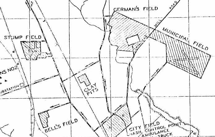
The earliest depiction which has been located of Bell's Field as an active airfield
was on a 1939 map of NAS Pensacola & its satellite fields (courtesy of Brian Rehwinkel).
It depicted Bell's Field as an irregularly-shaped plot of land.
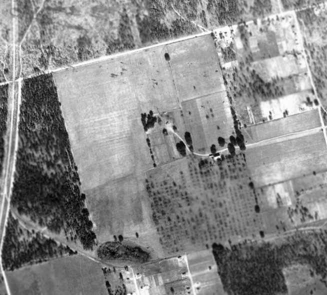
A 12/2/40 USDA aerial view of Bell's Field NOLF,
from the Digital Library Center / University of Florida George A. Smathers Libraries (courtesy of Brian Rehwinkel).
The airfield consisted of an 'L'-shaped grass area,
and there did not appear to be any buildings or other aviation facilities associated with the field.
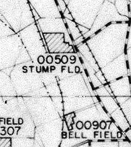
"Bell Field", as depicted on a 6/30/42 Map of Outlying Fields for NAS Pensacola (courtesy of Brian Rehwinkel).
Bell's Field was not depicted at all on the 1944 USGS topo map.
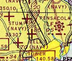
"Bells (Navy)" was still depicted as an active airfield (along with many others!)
on the February 1945 Mobile Sectional Chart (courtesy of Chris Kennedy).
Bell's Field was apparently abandoned by the Navy at some point between 1945-49,
as it was no longer depicted at all on the 1949 Mobile Sectional Chart (courtesy of John Voss),
and a January 1951 aerial photo showed some roads (apparently for development)
cutting across the field (according to Brian Rehwinkel).
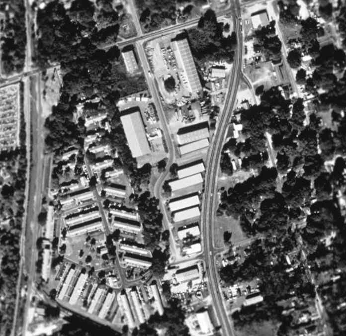
As seen in the 1999 USGS aerial photo of the site of Bell's Field,
North W Street was built through the center of the former airfield, and the area has become heavily developed,
with not a trace appearing to remain of the former Navy airfield.
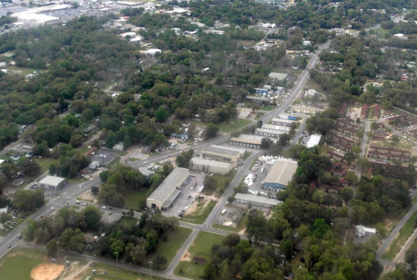
A 3/29/16 aerial view by Dallam Oliver-Lee looking south at the site of Bell's Field.
The site of Bell's Field is located south of the intersection of Massachusetts Avenue & Franklin Avenue.
____________________________________________________
Stump Field Naval Outlying Landing Field, Pensacola, FL
30.48 North / 87.25 West (West of Pensacola Regional Airport, FL)

"Stump Field", as depicted on a 1939 map of NAS Pensacola & its satellite fields (courtesy of Brian Rehwinkel).
Stump Field was one of the large number of auxiliary fields which were established by the Navy
to support flight training operations at the Pensacola Flight School.
According to Brian Rehwinkel, Stump Outlying Field was first leased by the Navy in July 1930.
The Navy leased 150 acres from the Wilson-Bear Realty Company for the sum of $50 / year.
Stump Field was one of approximately 6 "auxiliary landing fields"
(later called outlying fields) the Navy was using for training purposes by 1931.
This field was a prime example of the early training fields - a primitive, sod field.
In those early years the Navy was very frugal and, in an effort to cut costs,
the Navy (according to a May 1932 Navy memo) negotiated a reduction of the annual rental to $25 / year.
Stump Field was not yet depicted at all (possibly just overlooked due to its relatively small size?)
on the 1934 Navy Aviation Chart V-242 (courtesy of Chris Kennedy).
The earliest depiction of Stump Field which has been located
was on a 1939 map of NAS Pensacola & its satellite fields (courtesy of Brian Rehwinkel).
It depicted Stump Field as an irregularly-shaped plot of land.
By 1939, the annual rental for the 150-acre Stump Field property had "ballooned" to $75!
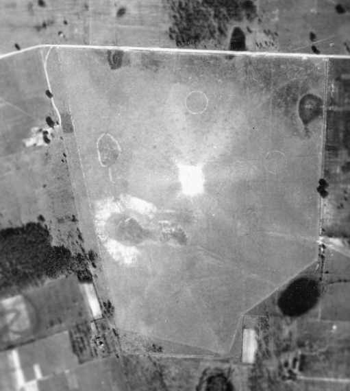
A 1/9/41 USDA aerial view of Stump Field NOLF,
from the Digital Library Center / University of Florida George A. Smathers Libraries (courtesy of Brian Rehwinkel).
The airfield consisted of an irregularly-shaped grass area,
and there did not appear to be any buildings or other aviation facilities associated with the field.
The 1941 USGS topo map (courtesy of Dallam Oliver-Lee) depicted Stump Field as an empty unlabeled area.

"Stump Field", as depicted on a 6/30/42 Map of Outlying Fields for NAS Pensacola (courtesy of Brian Rehwinkel).
Stump Field was used throughout the Second World War
and was also referred to as Field # 00509 -
being that it was located almost due north (005 degrees on the compass) and 9 miles from its parent field.
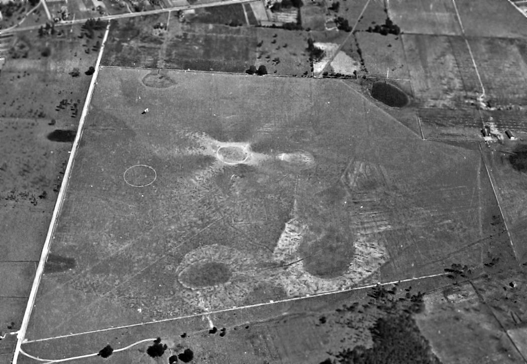
The last photo which has been located of Stump Field was a 2/16/43 U.S. Navy aerial view looking east (National Archives, via Brian Rehwinkel),
showing one biplane on the field (top-left).
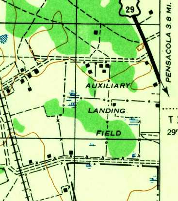
The 1944 USGS topo map depicted Stump Field as an irregularly-shaped property outline, labeled as “Auxiliary Landing Field”.
There were several buildings depicted within the property outline, but it is not known if these were directly related to the airfield.
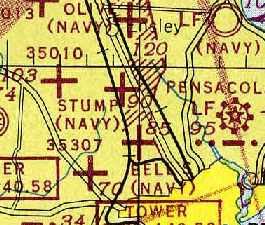
"Stump (Navy)" was still depicted as an active airfield (along with many others!)
on the February 1945 Mobile Sectional Chart (courtesy of Chris Kennedy).
Stump Field was apparently abandoned by the Navy at some point between 1945-49,
as it was no longer depicted at all on the 1949 Mobile Sectional Chart (courtesy of John Voss).
A 10/22/55 USGS aerial photo (courtesy of Dallam Oliver-Lee)
showed that U.S. Highway 29 had been recently built right through the center of the former Stump Field.
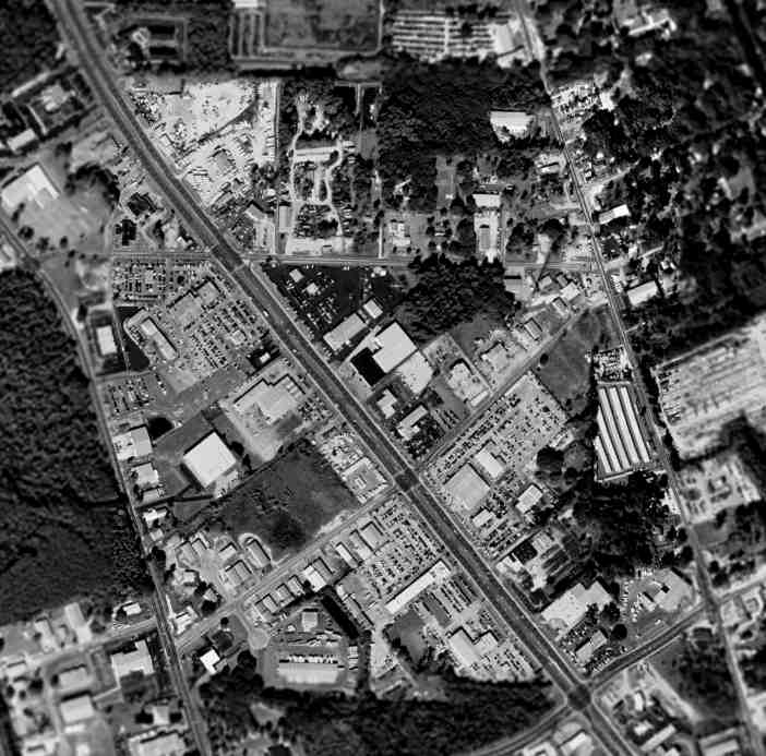
As seen in the 1999 USGS aerial photo of the site of Stump Field,
Route 29 was built through the center of the former airfield,
and the area has become heavily developed,
with not a trace appearing to remain of the former Navy airfield.
The site of Stump Field is located at the intersection of Route 29 & Stumpfield Road - pretty tricky, huh?
____________________________________________________
Clay Pits Naval Outlying Landing Field, Pensacola, FL
30.47 North / 87.23 West (West of Pensacola Regional Airport, FL)

"Clay Pits" NOLF, as depicted on a 1939 map of NAS Pensacola & its satellite fields (courtesy of Brian Rehwinkel).
Clay Pits NOLF was one of the large number of auxiliary fields which were established by the Navy
in the 1930s to support flight training operations at the Pensacola Flight School.
It was evidently named for the clay pits which still sit just to the south of the site of the airfield.
Clay Pits NOLF was yet not depicted on the 1934 Navy Aviation Chart V-242 (courtesy of Chris Kennedy).
According to a February 1935 Navy memo (via Brian Rehwinkel),
Clay Pits Outlying Field was first used by the Navy as early as 1934.
It was used for "emergency precision landing instruction".
During the first years of use, the Navy had no formal agreement with the owners of the property (L & N Railroad).
Apparently it wasn’t until September 1939 that the Navy had a formal lease to use the tiny 23 acre property as a landing field.
The Navy leased the property for $150 / year.
The earliest depiction of Clay Pits NOLF which has been located
was on a 1939 map of NAS Pensacola & its satellite fields (courtesy of Brian Rehwinkel).
It depicted Clay Pits NOLF as an L-shaped field,
and it was extremely small for a Navy airfield, even for an auxiliary field in the 1930s.
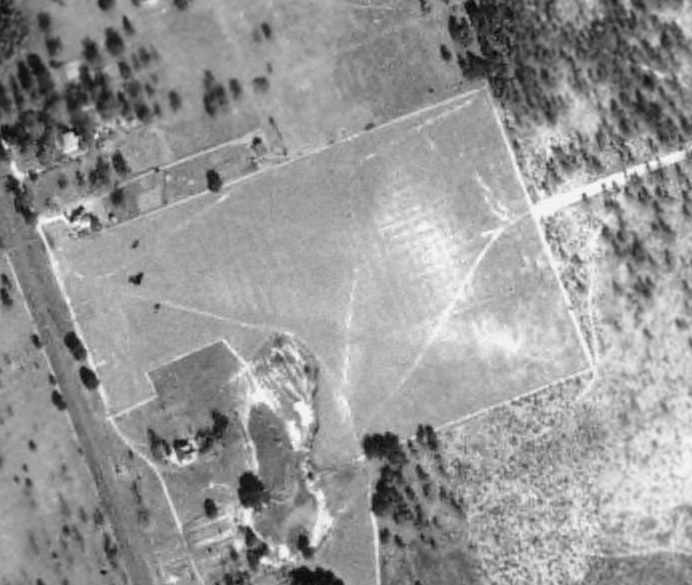
A 1940 USDA aerial view of Clay Pits NOLF,
from the Digital Library Center / University of Florida George A. Smathers Libraries (courtesy of Brian Rehwinkel).
The airfield consisted of a very small grass area,
rectangular except for a cut-out at the southwest corner (presumably from a property owner who refused to sell!),
and there did not appear to be any buildings or other aviation facilities associated with the field.
Clay Pits NOLF was only used for a short time during World War Two.
In an April 29, 1942 letter from the Office of the Judge Advocate General (via Brian Rehwinkel),
the Navy informed L & N Railroad they had decided to terminate the lease, effective June 30, 1942.
The letter did not give a reason, but with so many other landing fields in the area,
such a small parcel was probably not useful any longer,
as the heavier aircraft used for training during WW2 required longer runways.
Clay Pits OLF did not appear at all on the 6/30/42 Map of Outlying Fields for NAS Pensacola,
the 1944 USGS topo map, or the February 1945 Mobile Sectional Chart (courtesy of Chris Kennedy).
A 10/22/55 USGS aerial photo (courtesy of Dallam Oliver-Lee)
showed that the site of Clay Pits OLF was beginning to be covered by unrelated buildings.
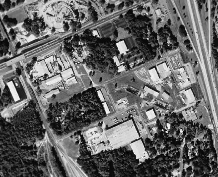
As seen in the 1999 USGS aerial photo of the site of Clay Pits NOLF,
the property has redeveloped with a variety of buildings,
and not a trace appears to remain of the former Navy airfield.
The site of Clay Pits NOLF is located east of the intersection of Brent Lane & Sycamore Drive.
____________________________________________________
German's Field Naval Outlying Landing Field, Pensacola, FL
30.48 North / 87.21 West (Northwest of Pensacola Regional Airport, FL)

"German's Field", as depicted on a 1939 map of NAS Pensacola & its satellite fields (courtesy of Brian Rehwinkel).
German's Field was one of the large number of auxiliary fields which were established by the Navy
in the late 1930s to support flight training operations at the Pensacola Flight School.
The date of establishment of German's Field has not been determined.
It was not depicted on the 1934 Navy Aviation Chart V-242 (courtesy of Chris Kennedy),
nor in The Airport Directory Company's 1937 Airports Directory (courtesy of Bob Rambo).
The earliest depiction of German's Field which has been located
was on a 1939 map of NAS Pensacola & its satellite fields (courtesy of Brian Rehwinkel).
It depicted German's Field as an irregularly-shaped plot,
directly across Skinner's Mill Road (to the west) from Pensacola Municipal Field.
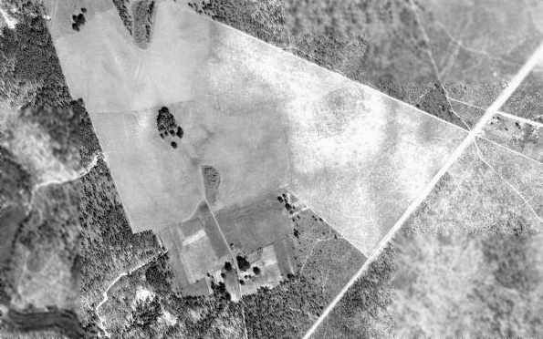
A 1940 USDA aerial view of German's Field NOLF,
from the Digital Library Center / University of Florida George A. Smathers Libraries (courtesy of Brian Rehwinkel).
The airfield consisted of an irregularly-shaped grass area,
and there did not appear to be any buildings or other aviation facilities associated with the field.
It has not been determined how much longer German's Field was used by the Navy.
It was apparently abandoned at some point between 1940-44,
as it was not listed in the April 1944 US Army/Navy Directory of Airfields (courtesy of Ken Mercer)
or depicted on the 1944 USGS topo map or the February 1945 Mobile Sectional Chart (courtesy of Chris Kennedy).
Its location directly adjacent to Pensacola Municipal Field probably contributed to its demise,
as air traffic became increasingly dense in the Pensacola area during the WW2 years.
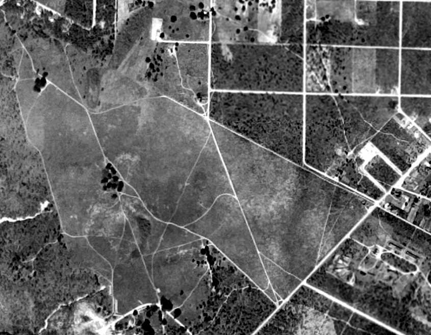
A 10/22/55 aerial view (courtesy of Dallam Oliver-Lee) still showed the irregularly-shaped outline of German's Field,
but did not show any indication of aviation use.
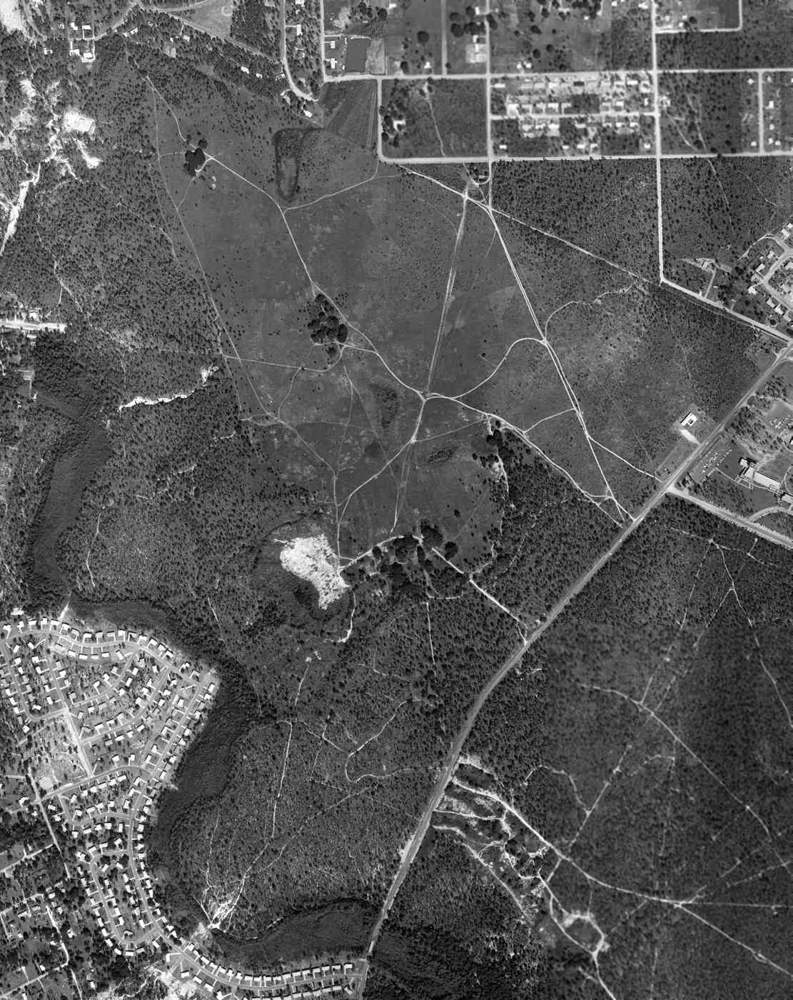
A 10/12/61 FLDOT aerial view (courtesy of Dallam Oliver-Lee) still showed the irregularly-shaped outline of German's Field.
A November 1979 aerial view (courtesy of Dallam Oliver-Lee) showed commercial buildings having been built over the eastern portion of German's Field.
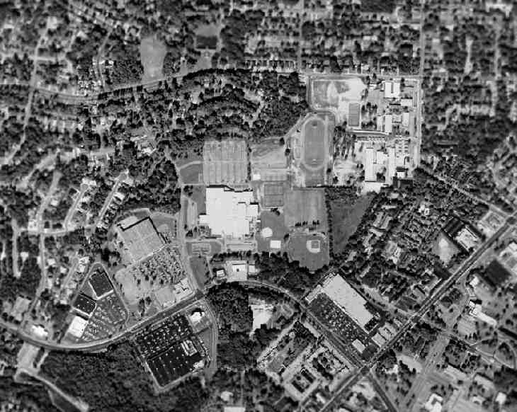
As seen in the 1999 USGS aerial photo of the site of German's Field,
the property has been densely redeveloped with housing & several schools,
and not a trace appears to remain of the former Navy airfield.
The site of German's Field is located west of the intersection of Route 289 & Underwood Avenue.
____________________________________________________
Since this site was first put on the web in 1999, its popularity has grown tremendously.
That has caused it to often exceed bandwidth limitations
set by the company which I pay to host it on the web.
If the total quantity of material on this site is to continue to grow,
it will require ever-increasing funding to pay its expenses.
Therefore, I request financial contributions from site visitors,
to help defray the increasing costs of the site
and ensure that it continues to be available & to grow.
What would you pay for a good aviation magazine, or a good aviation book?
Please consider a donation of an equivalent amount, at the least.
This site is not supported by commercial advertising –
it is purely supported by donations.
If you enjoy the site, and would like to make a financial contribution,
you
may use a credit card via
![]() ,
using one of 2 methods:
,
using one of 2 methods:
To make a one-time donation of an amount of your choice:
Or you can sign up for a $10 monthly subscription to help support the site on an ongoing basis:
Or if you prefer to contact me directly concerning a contribution (for a mailing address to send a check),
please contact me at: paulandterryfreeman@gmail.com
If you enjoy this web site, please support it with a financial contribution.
please contact me at: paulandterryfreeman@gmail.com
If you enjoy this web site, please support it with a financial contribution.
____________________________________________________
This site covers airfields in all 50 states.