Abandoned & Little-Known Airfields:
Florida, Southwestern Pensacola area
© 2002, © 2016 by Paul Freeman. Revised 11/5/16.
This site covers airfields in all 50 states: Click here for the site's main menu.
____________________________________________________
Please consider a financial contribution to support the continued growth & operation of this site.
Bauer NOLF (revised 11/24/13) - Bayou NOLF (revised 4/23/13) - Chevalier Field NAS (revised 10/29/15) - Tarkiln Field / Bronson Field NAAS (revised 11/5/16)
____________________________________________________
Bauer Naval Outlying Landing Field, Southwest Pensacola, FL
30.34, -87.41 (Southwest of Pensacola, FL)

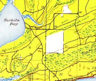
The 1941 USGS topo map (courtesy of Dallam Oliver-Lee) depicted a rectangular clearing at the site of Bauer Field, but did not label it.
Bauer Field was one of the huge number of auxiliary airfields established in the pre-WW2 buildup
to support Navy flight training in the Pensacola area.
According to Brian Rehwinkel, “Bauer was part of a large expansion of outlying fields in 1940 & 1941.
Bauer was one of around 17 fields that were purchased by the Navy in Pensacola during this period
(some were fields that had been previously been leased, and some were completely new airfields).
Bauer OLF was originally called 'Site 1940-e'.
The Bureau of Aeronautics number for this fields was # 26708.
'Bauer' was the name of the landowners of the 1,280 acres of leased land.”
Brian continued, “The Navy purchased the just under 120 acres in early 1941 & developed a sod airfield for training.
The field was expanded to include an additional 1,280 acres for a total of 1,400 acres.
The original portion was used as the landing field & the additional land was supposed to be used for a bombing range or bomb targets
(apparently, the Navy never used the land for bombing).
The airfield was on land owned by the Navy & the additional 1,280 acres was leased.”
The earliest possible depiction which has been located of Bauer Field was the 1941 USGS topo map (courtesy of Dallam Oliver-Lee),
which depicted an unlabeled rectangular clearing.

Bauer Field & Bronson Field, as depicted on a 6/30/42 map showing the location of Outlying Fields for NAS Pensacola (National Archives, courtesy of Brian Rehwinkel).

The earliest photo which has been located of Bauer Field was a 2/16/43 U.S. Navy aerial view looking north,
showing the landing circle in the middle of the field (National Archives, courtesy of Brian Rehwinkel).
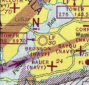
The earliest aeronautical chart depiction which has been located of Bauer Fied
was on the February 1945 Mobile Sectional Chart (courtesy of Chris Kennedy).
It depicted “Bauer (Navy)” as an auxiliary airfield.
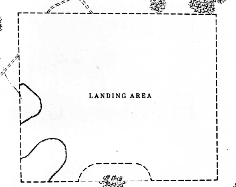
The 1945 AAF Airfield Directory (courtesy of Brian Rehwinkel) described “Bronson Field Auxiliary (26708 Bauer Outlying Field)”
as a rectangular property having a sod all-way landing area.
The field was not said to have any hangars, to owned by the U.S. Government & operated by the Navy.
According to Brian Rehwinkel, “Although Bauer OLF was originally used by planes from NAS Pensacola, it was assigned to NAS Bronson during World War II.
In April 1945, the Navy transferred the 120 acre landing field portion to the US Coast Guard,
with the provision the Navy could still use the field for emergency landings & for the dropping of sleeve targets.
The Navy continued to lease the 1,280 acres for a short period of time after the war.
I do not know when the Navy abandoned the field, but I am guessing they (or the Coast Guard) probably didn’t use the field much after WWII.”
Bauer Field was evidently closed at some point between 1945-49,
as it was no longer depicted on the 1949 Mobile Sectional Chart.
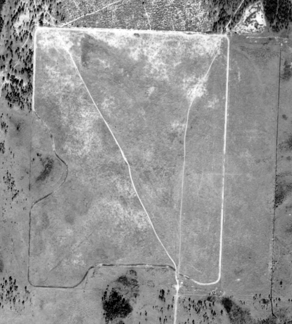
A 1/4/51 USGS aerial view of Bronson Field (courtesy of Dallam Oliver-Lee) depicted a rectangular grass field,
but did not show any other improvements nor any sign of recent usage.
Brian Rehwinkel observed, “I am guessing the Navy disposed of the land – probably in the 1950s, along with several other fields in the Pensacola area.”
A 1965 USGS aerial view (courtesy of Dallam Oliver-Lee) showed Sorrento Road had been built through the center of the airfield site.
A 1979 USGS aerial view (courtesy of Dallam Oliver-Lee) showed the Bauer Field property remained otherwise unredeveloped.

A 1/3/12 aerial view (courtesy of Dallam Oliver-Lee) showed no recognizable trace remaining of Bauer Field,
with a middle school & housing occupying most of it.
The site of Bauer Field is located southwest of the intersection of Meadson Road & Bauer Road,
the name of which is the only apparent remnant of the airfield.
____________________________________________________
Bayou Naval Outlying Landing Field / 29904 Outlying Field, Pensacola, FL
30.37 North / 87.32 West (North of NAS Pensacola, FL)

A September 1, 1936 plat plan of the property of Bayou Field (from Navy files at the National Archives, courtesy of Brian Rehwinkel).
According to Navy records in the National Archives (via Brian Rehwinkel),
Bayou Field was first used by the Navy sometime in the early 1930s (before 1935).
The L-shaped grass field consisted of about 83 acres.
It was one of approximately 12 "auxiliary landing fields" (later called outlying fields)
the Navy was using for training purposes by 1935 to support flight training operations at the Pensacola Flight School.
These early training fields were very primitive fields,
often consisting of simple clearings, with relatively small landing areas.
A February 1935 memo to the Commandant of NAS Pensacola (describing the station’s outlying fields)
spoke of the conditions at Bayou Field, stating,
"The high telephone lines in the North end of this field render it unsuitable for student training,
except under south wind conditions and it is accordingly rarely used."
Apparently, that condition was corrected, because the field was used for aviation purposes for most of the next 10 or 15 years.

The earliest depiction of Bayou Field which has been located
was on a 1939 map of NAS Pensacola & its satellite fields (courtesy of Brian Rehwinkel).
It depicted Bayou Field as having an "L"-shaped airfield area.
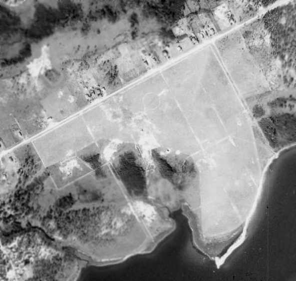
A 12/6/40 USDA aerial view of Bayou Field,
from the Digital Library Center / University of Florida George A. Smathers Libraries (courtesy of Brian Rehwinkel).
As depicted in the above 1940 aerial photo, the airfield consisted of an irregularly-shaped grass area,
with runways oriented northeast/southwest & northwest/southeast.
There did not appear to be any buildings or other aviation facilities associated with the field.
What may have been a single airplane was visible on the center of the field, just south of the airfield circle.
The 1944 USGS topo map depicted the property outline of Bayou Field, but did not label the airfield.
"Bayou (Navy)" was still depicted as an active military airfield
on the 1945 Mobile Sectional Chart (courtesy of John Voss).
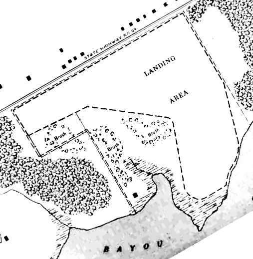
The 1945 AAF Airfield Directory (courtesy of Scott Murdock) described “Corry Field Auxiliary (29904 Outlying Field)”
as an 83 acre irregularly-shaped field having a 2,425' x 2,100' turf all-way landing area.
The field was not said to have any hangars,
to owned by the U.S. Government & operated by the Navy.
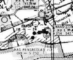
Bayou Field was evidently abandoned by the Navy at some point between 1945-49 & reused as a civilian airport,
as that is how it was depicted on the 1949 Mobile Sectional Chart (courtesy of John Voss).
"Bayou" was described as having a 2,400' unpaved runway.

A 1/5/51 USDA aerial view of Bayou Field,
from the Digital Library Center / University of Florida George A. Smathers Libraries (courtesy of Brian Rehwinkel).
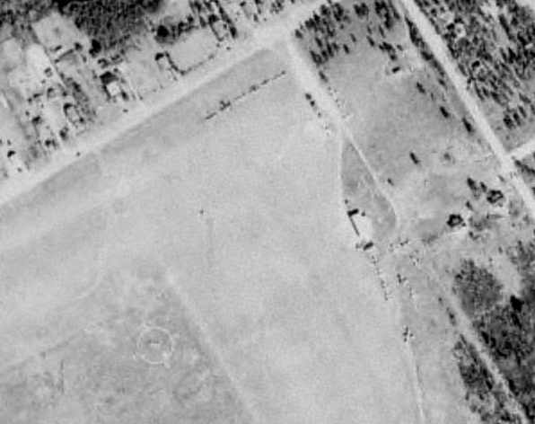
Bayou Field was evidently still very much in use in 1951,
as this close-up of the 1/5/51 USDA aerial view depicted a total of at least 19 aircraft on the field.
A single small hangar or shed was visible along the east side of the field.
According to Brian Rehinkel, "Following WW2, the Army abandoned Fort Barrancas
[a nearby WW2 Army coastal defense post] and transferred the land to the Navy.
The Navy then built Forrest Sherman Field - which became operational in 1955.
Undoubtedly, this meant the end for Bayou Field,
as it was located almost directly in the path of Sherman Field's north/south runway."
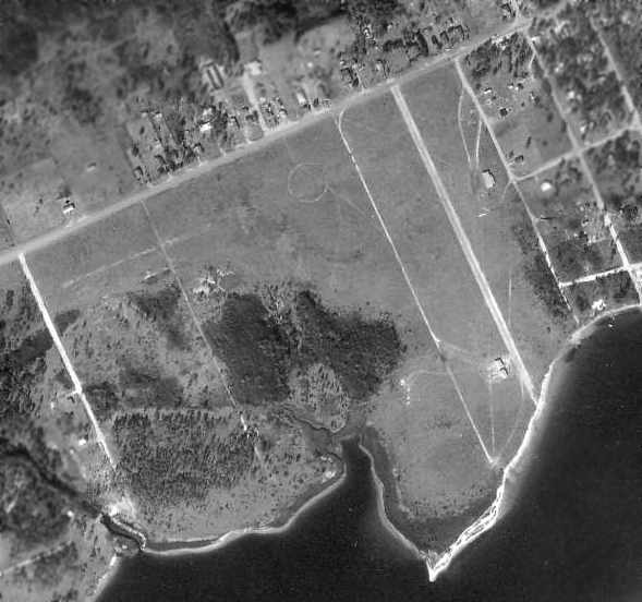
A 1/3/58 USDA aerial view of Bayou Field,
from the Digital Library Center / University of Florida George A. Smathers Libraries (courtesy of Brian Rehwinkel).
"The field has been abandoned at this point & roads for development are being cut into the area of the former field."
By the time of the 1964 Mobile Sectional Chart (courtesy of John Voss),
Bayou Field no longer depicted at all.

The last photo which has been located showing Bayou Field intact was a 1/31/65 USGS aerial view (courtesy of Dallam Oliver-Lee).
The large airfield circle marking was still prominent,
and 3 shacks or small hangars were visible on the southeast side.
By the time of A November 1975 USGS aerial photo (courtesy of Dallam Oliver-Lee),
the middle of the site of Bayou Field had been covered in housing.
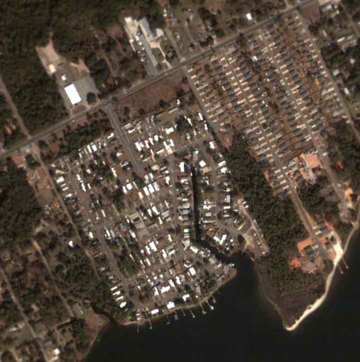
A 2004 aerial view of the site of Bayou Field.
According to Brian Rehinkel, "Today most of the location of the former field is occupied by housing,
with a small portion still remaining undeveloped (wooded)."
Not a trace appears to remain of the former Navy airfield.
The site of Bayou Field is located south of the intersection of Route 292 & Gulf Breeze Avenue.
____________________________________________________
Chevalier Field Naval Air Station, Pensacola, FL
30.36 North / 87.27 West (West of Pensacola NAS, FL)
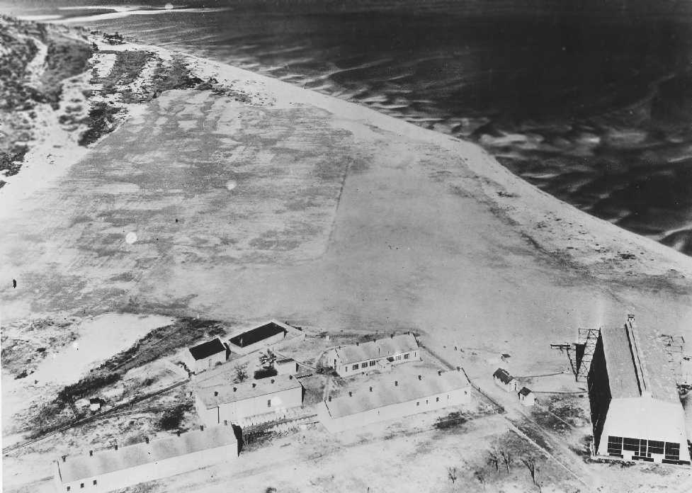
A circa 1917 aerial view looking north (from the Emil Beuhler Library at the National Naval Aviation Museum at Pensacola, courtesy of Maureen Keillor),
captioned, “Woolsie cleared to make Chevalier Field.”
The Pensacola Navy Yard was established in 1826.
The Navy's flying school was established here in 1913, beginning a long association with naval aviation.
Pensacola was designated a Naval Air Station in 1917, and was significantly expanded,
although the aircraft based at the station still consisted of seaplanes & dirigibles.
The need for a field for landplane operations was obvious,
so in 1922 the Navy razed the small town of Woolsey, just north of the Navy Yard,
and built an airfield, initially called Station Field.
An auxiliary field, Corry Field, was added that year.

A circa 1920s aerial view (from the Emil Beuhler Library at the National Naval Aviation Museum at Pensacola, courtesy of Maureen Keillor)
looking west at a long row of biplanes in front of the Chevalier Field hangars.
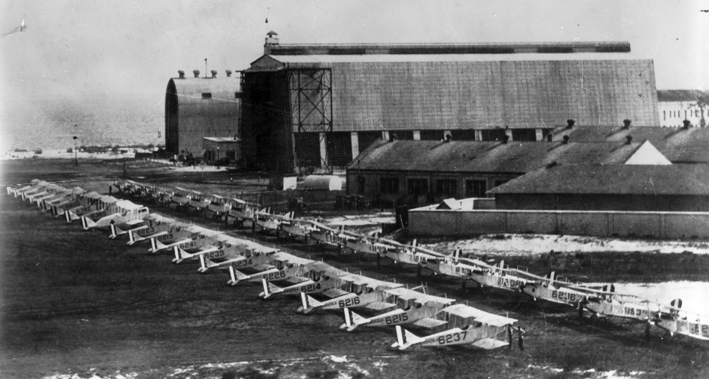
An undated (circa 1920s?) view of rows of JN-1H trainers in front of 2 large hangars at Chevalier Field (from the Emil Buehler Library at the NNAM, via Maureen Keillor).
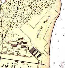
A 1925 NOAA map (courtesy of Dallam Oliver-Lee) depicted the Chevalier “Landing Field” as having 2 unpaved runways,
oriented northwest/southeast & northeast/southwest, with a row of hangars along the southwest side.
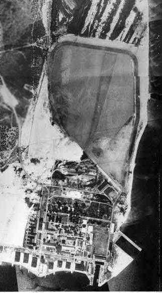
A 1933 aerial photo (courtesy of Dallam Oliver-lee) depicted Chevalier as having an unpaved airfield
with a row of hangars along the southern side.
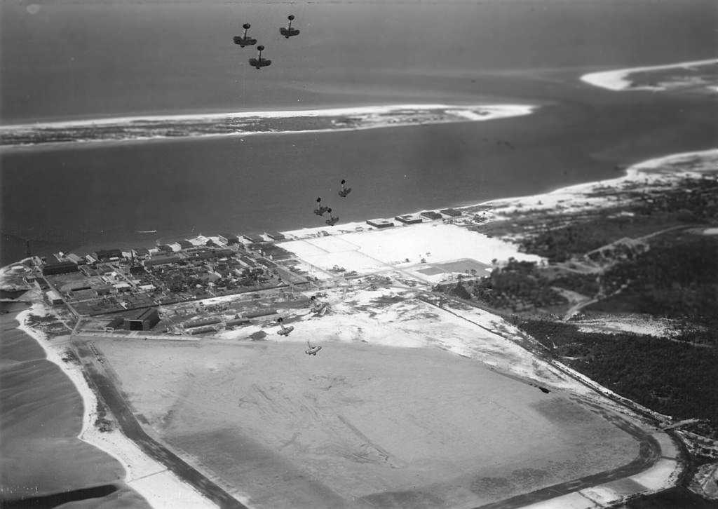
A 5/5/34 aerial view looking south at the 'Gymkhana Hop' stunt team of VN-508's F2B-1s performing aerobatics over Chevalier.
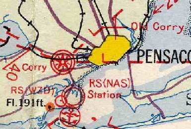
NAS Station Field, as depicted on the 1934 Navy Aviation Chart V-242 (courtesy of Chris Kennedy).

The airfield layout of Pensacola "Station Field",
as depicted on the 1934 Navy Aviation Chart V-242 (courtesy of Chris Kennedy).
It described Pensacola "Station Field" as consisting of a 3,600' x 2,200' sand & clay field,
with an asphalt taxiway along the north & east sides.
In 1935 the Navy enlarged Station Field, paved it, and renamed in Chevalier Field.
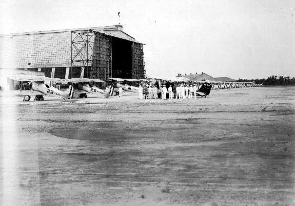
An undated (circa 1930s?) view of Vought O2U-3 biplanes in front of a Chevalier Field hangar.
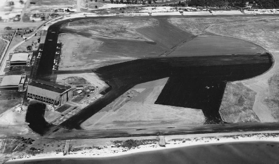
A 7/12/37 aerial view looking west at Chevalier Field (courtesy of Brian Rehwinkel).
A blimp hangar & 2 aircraft hangars were at the south end of the field.
Brian observed, “This photo shows the field after the south end had been partially paved.
The north end of the field was still sod.
This field is an interesting study in how the military fields changed over time.
It was one of the first land fields the Navy built, and it was modified many times over the years.
It was just too small to handle planes as they became larger & faster.”
The field was further expanded in 1938,
adding schools for aviation medicine & aviation maintenance.
A procession of additional auxiliary fields were added in the next few years, including Saufley Field in 1940 & Ellyson Field in 1941.
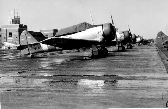
A 1941 photo of rows of North American SNJ-1 trainers in front of Chevalier Field's control tower.
With the entrance of the US into WW2,
primary flight training at Chevalier increased in pace from 800 to 2,500 students per month.
Chevalier Field continued to gain additional outlying fields during WW2, including Bronson Field & Barin Field in 1942, and Whiting Field in 1943.
Primary flight training at Chevalier ended in 1943,
and it became headquarters of the Naval Air Intermediate Training Command.
In addition to the landplane facilities, Chevalier Field had 2 adjacent seaplane bases,
with the larger one to the south of the airfield, and a smaller one to the northeast.

A colorized postcard of an undated (circa 1940s?) Navy photo of Chevalier Field.

A colorized postcard of an undated (circa 1940s?) photo of flight students in front of a Chevalier Field hangar.

A 1943 photo of a busy Chevalier ramp, showing a Douglas R4D, Beech SNBs, North American SNJs, and a few biplanes (from the Emil Buehler Library at the NNAM, via Maureen Keillor).

The 1944 USGS topo map depicted Chevalier Field as an open “Landing Field”, and depicted “Seaplane runways” to the southwest.
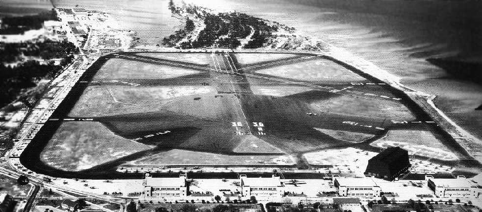
A WW2-era view looking north at Chevalier Field (National Archives photo).
The number of aircraft hangars at the south end of the field had been doubled to 4 since the 1937 photo, and the blimp hangar was still standing.
Note the seaplane facilities at the top-left.
At its height during WW2, Chevalier had a total of 7 asphalt runways (the largest was 3,100' long) arranged in 2 clusters,
with a 1,100' diameter circular asphalt landing pad in the center of the southern runway cluster.
Because of its relatively short runways,
Pensacola's staff transport aircraft were based instead at Corry Field.
A variety of aircraft were based at Chevalier during WW2,
including OS2U, SC & N3N floatplanes, PBY seaplanes,
and SNJ, SNV, N3N & N2S landplanes.
By the end of WW2, Chevalier & its auxiliaries had trained a total of over 28,000 pilots.
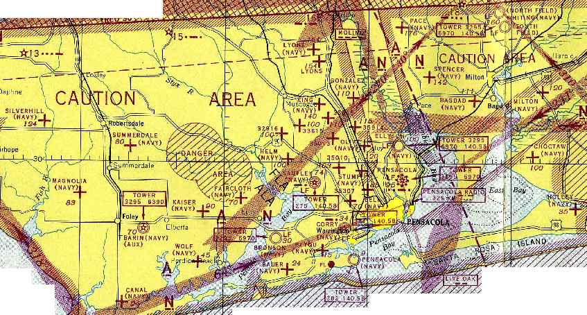
The incredible number of Navy satellite fields in the Pensacola area during WW2,
as depicted on the February 1945 Mobile Sectional Chart (courtesy of Chris Kennedy).
After WW2, Pensacola remained the headquarters of the Naval Air Training Command.
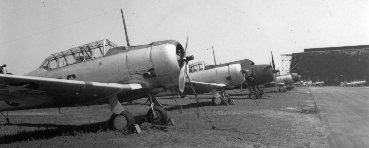
A circa 1950 photo by Wayne Bancroft (courtesy of George Mihal of the Office of Image Archeology) of North American SNJ Texans in front of the Chevalier Field blimp hangar.

A circa 1950 photo by Wayne Bancroft (courtesy of George Mihal of the Office of Image Archeology) of a Stearman biplane in front of the Chevalier Field control tower.
For the short runways of Chevalier Field, the advent of jet aircraft meant that its days were numbered.
To provide the longer runways needed by jets, Forrest Sherman Field was opened in 1955, three miles to the west.
Chevalier Field remained open for limited operations,
but the Naval Air Technical Training Center was eventually built over the southwest portion of the airfield.
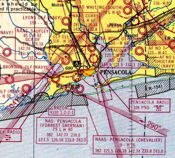
A 1956 aeronautical chart (courtesy of Dallam Oliver-Lee) depicted “NAAS Pensacola (Chevalier)”
(among a dizzying array of Pensacola-area airfields) as having a 2,600' paved runway.

An 8/8/59 aerial view (from the Emil Beuhler Library at the National Naval Aviation Museum at Pensacola, courtesy of Maureen Keillor)
looking north at a flight of 4 Lockheed T2V SeaStars overflying Chevalier Field.

Chevalier Field was depicted on the 1960 Jeppesen Airway Manual (courtesy of Chris Kennedy)
as having 3 paved runways, with the longest being the 2,60' Runway 13/31.
The blimp hangar was still depicted on the southeast corner of the field.
"NAS Pensacola (Chevalier Field)" was depicted as an active airfield on the 1964 Mobile Sectional Chart (courtesy of John Voss).
The airfield was described as having a total of 7 asphalt runways, with the longest being 2,650'.
However, the remarks said, "Runways 13R/31L & 9R/27L permanently closed.
Closed to transients, local test flights only."

A 1/31/65 aerial photo (courtesy of Dallam Oliver-lee) showed a large number of aircraft parked around Chevalier Field,
including some larger twin-engine aircraft on the south side.
Rene' Freret recalled, “I was stationed at NAS Pensacola from 1970-74 and was assigned to Sherman Field Crash Crew.
Many times I took my truck & crew to stand by at Chevalier Field on Mainside.
The large brick buildings around the southern edge were at that time Huey helicopter rework facilities.
The only flight ops were Huey test flights.”
Chevalier Field was apparently closed as an airfield by 1976,
as it was labeled "NAS Pensacola Chevalier (Closed)"
on the January 1976 New Orleans Sectional Chart (courtesy of Chris Kennedy).

The 1992 USGS topo map still depicted “Chevalier Field” as having several runways,
although it also depicted that 3 large buildings had been built over portions of runways on the southwest side of the field.
These may have been hangars constructed for helicopter operations which were conducted at Chevalier Field during its latter days.
The 1930s-era blimp hangar had evidently been removed at some point between 1960-92.

A portion of the former airfield was apparently still used for a while for helicopter operations,
as several helicopters were visible on parking spots in the southeast part of the field in the 1/30/94 USGS aerial photo.
The use of Chevalier Field for helicopter operations apparently ended at some point between 1994-96.
Scott Beadle recalled, "While I was enlisted in the Marines I received my training at NATTC Pensacola,
located on the old Chevalier Field.
I attended the basic airframe mechanic course when the facility opened from November 1996 – March 1997
and the NDI course from July 1998 - November 1998.
I wasn't even aware that the area had been an airfield until my second time there.
The 4 old hangars on the South side of the field have been reused as (west to east):
the new base exchange, a weight gym/movie theater, the new auto hobby shop, and a basketball gym.
The large hangars on the West side of the field have all been incorporated into the new school.
This is known as the 'megabuilding' which is an apt description.
There are twelve barracks buildings & a mess hall located where the runways were.
While I hate to see an airfield destroyed,
the area has been turned into a beautiful campus for the Navy & Marines aviation schools.
The 11/26/99 USGS aerial photo showed a drastically different configuration compared to the 1994 photo -
all of the remaining runway portions had been covered by buildings.
Navy pilot Mike Strobach reported in 2002 on the former hangars which remain at Chevalier,
"One of them, which now houses the Navy Exchange,
has the remnants of a control tower on the northwest corner facing the NATTC.
There is a sign on the control tower that clearly indicates the field elevation.
There are also several seaplane hangars on the shoreline along Escambia Bay on the south end of the base.
One of them has been converted to a gym."
Chevalier was no longer listed with the FAA among active aviation facilities as of 2002.
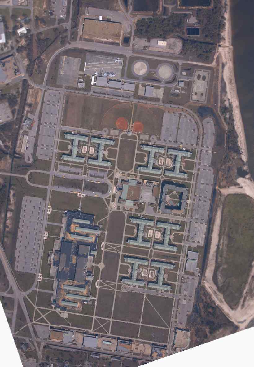
A September 2004 NOAA aerial photo of the former Chevalier Field (courtesy of Brian Rehwinkel).
Note the drastic contrast in the configuration of the site compared to the 1994 aerial photo.
The majority of the middle of the former airfield has been covered by training buildings,
with the only remaining hangars being the row along the south side of the field.
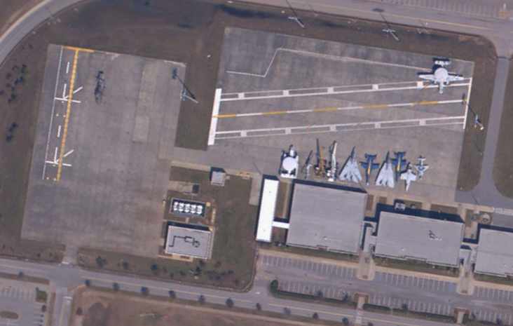
A close-up from the September 2004 NOAA aerial photo (courtesy of Brian Rehwinkel),
showing what is apparently an aircraft-carrier deck aircraft handling training facility,
with the asphalt pad on the left marked with the markings of a helicopter carrier,
and the pad on the right marked with the markings of an aircraft carrier.
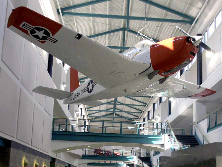
A January 26, 2005 Navy photo by Mark Ebert of a Beech T-34B Mentor hanging in the north atrium
of the newly renovated Chevalier Hall building at the Naval Air Technical Training Center at NAS Pensacola.
Note a 2nd, unidentified aircraft (an Interstate TDR?) hanging in the background.

A circa 2006 aerial view looking east at the hangar along the southwest corner of Chevalier Field.
Note the former control tower base on the lower-left corner of the hangar (apparently the control tower cab had been removed).

A January 2006 photo by Paul Freeman, looking southeast at the Aviation Division training facility adjacent to the north side of Chevalier Field.
The aircraft used here to conduct deck-handling training include a relatively rare ES-3 (electronic reconnaissance version of the S-3)
and an F/A-18 in Blue Angels markings.

A January 2006 photo by Paul Freeman, looking northwest at one of the WW2-era hangars
which remain standing along the south side of the former Chevalier Field.

A January 2006 photo by Paul Freeman, looking southeast at one of the circa 1960-92 former hangars
which remain standing along the west side of the former Chevalier Field.
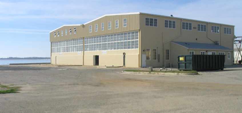
A January 2006 photo by Paul Freeman, looking southwest at one of the remaining former seaplane hangars at NAS Pensacola.
The area along the seaplane ramp had suffered extensive hurricane damage,
with several extensively-damaged buildings in the process of being taken down.

A December 2012 photo by Maureen Keillor of one of the WW2-era hangars which remain standing along the south side of the former Chevalier Field.
See also:
“Naval Air Station Pensacola” by Maureen Keillor,
____________________________________________________
Tarkiln Field / Bronson Field Naval Auxiliary Air Station,
Myrtle Grove, FL
30.39, -87.41 (Northwest of Pensacola NAS, FL)

What was originally known as "Tarkiln Field",
as depicted on a 1939 map of NAS Pensacola & its satellite fields (courtesy of Brian Rehwinkel).
The Navy purchased 640 acres in 1939 to establish an outlying field for the use of trainer aircraft from Corry Field.
It was initially known as Tarkiln Field, due to its proximity to Tarkiln Bay.
The earliest depiction which has been located of Tarkiln Field
was on a 1939 map of NAS Pensacola & its satellite fields (courtesy of Brian Rehwinkel).
It depicted Tarkiln Field as a rectangular area.
The 1941 USGS topo map (courtesy of Dallam Oliver-Lee) depicted Tarkiln Field as an empty unlabeled rectangular area.

Bronson Field & Bauer Field, as depicted on a 6/30/42 map showing the location of Outlying Fields for NAS Pensacola (courtesy of Brian Rehwinkel).
Additional construction began on the airfield in 1942,
and the Navy purchased an additional 263 adjoining acres on the shore of Perdido Bay to establish a seaplane facility.
The 2 installations were commissioned on 11/18/42 as NAAS Bronson Field.

The earliest photo which has been located of Bronson Field was a series of 1943 photos of a Piper HE-1 ambulance plane being loaded with a patient (courtesy of John Voss),
with a hangar visible in the background.

A 1943 photo of a Piper HE-1 ambulance plane being loaded with a patient at Bronson Field (courtesy of John Voss),
with the control tower visible in the background.
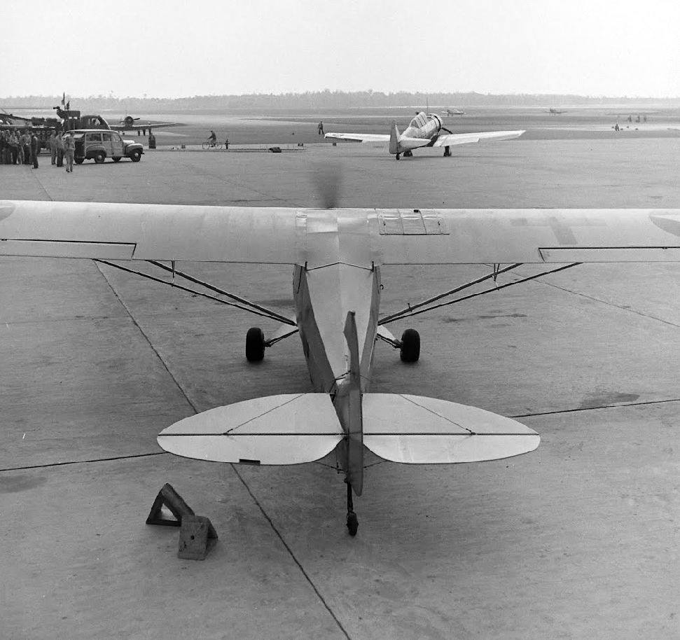
A 1943 photo of a Piper HE-1 ambulance plane at Bronson Field (courtesy of John Voss),
with SNJ Texans also visible in the background.
Strangely, Bronson Field was not depicted at all on the 1944 USGS topo map.
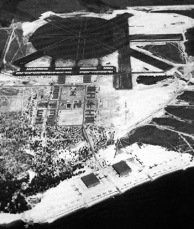
A WW2-era aerial view looking northwest at the runways & seaplane ramp at Bronson Field (National Archives photo).
The airfield at Bronson consisted of a large asphalt circular mat,
crisscrossed by 4 asphalt 4,000' runways, along with taxiways, ramps, and 2 hangars.
The seaplane facility consisted of 2 hangars, a large parking apron, and 5 seaplane ramps leading down into Perdido Bay.
A large complex of barracks in between the 2 flying facilities was capable of housing a total of 2,928 personnel.
Training squadron VN-5 transferred to Bronson from Corry Field,
and ultimately operated nearly 300 SNJs from Bronson Field.
The squadron also operated a smaller number of N2S Stearmans.
At the seaplane base, VN-8 operated 40 PBY Catalina flying boats.

The 1945 AAF Airfield Directory (courtesy of Scott Murdock) depicted “Bronson Seaplane Airport”
as having a large apron with 5 ramps leading into the water, and 2 hangars with 119' x 30' doors.
The field was said to be owned by the U.S. Government & operated by the Navy.
The 1945 AAF Airfield Directory (courtesy of Scott Murdock) depicted “Bronson Field”
as a 918 acre irregularly-shaped field having 4 asphalt runways (the largest being a 4,250' northeast/southwest strip),
and a 2,500' circular asphalt mat.
The field was said to have 2 wooden hangars, the largest measuring 300' x 174'.
The field was said to be owned by the U.S. Government & operated by the Navy,
and to have 3 auxiliary fields: 26708 Bauer Outlying Field (3 miles south),
30014 Faircloth Outlying Field, and 28817 Kaisers Tract Outlying Field (8 miles WNW).

"Bronson (Navy)", as depicted on the February 1945 Mobile Sectional Chart (courtesy of Chris Kennedy).
Two outlying grass fields were established for the use of Bronson's squadrons during WW2:
Faircloth Airport (Lillian, AL) & Kaiser's Tract (Elberta, AL).
Unlike the vast majority of the WW2-era outlying fields, Faircloth remained in use by the Navy through the 1960s,
in all likelihood making it the last grass field in use by the Navy.
No trace remains of either of these outlying fields today.
Bronson closed as a NAAS in 1946, but it remained in use as an outlying field.
The Navy tore down most of the temporary wartime buildings in the 1950s,
but continued to use the hangars for parts storage for the next 10 years.

A 10/22/52 USGS aerial view of Bronson Field (courtesy of Dallam Oliver-Lee)
showed the field remaining intact.

A 1956 aeronautical chart (courtesy of Dallam Oliver-Lee) depicted Bronson OLF
(among a dizzying array of Pensacola-area airfields) as having a 4,300' paved runway.
Robert Cooper recalled, “In 1958 the Navy decided to sell all of the old SNJ trainers which had been gathered at Bronson Field.
All but 2 of them were bought by 2 different salvage dealers.
The Navy refused to let them be flown from Navy property so the dealers leased a few acres of land just across from the entrance road
and the Navy allowed them to cut a hole in the fence & drag all the planes to their leased property.
The building [the wooden building just north of the airfield] was their sales office & parts storage. It did not belong to the Navy.
A short dirt strip was cleared leading away from the entrance road & most of the planes were flown from there.
I personally flew at least 25 of the planes from there to Pensacola airport where their new owners picked them up.
At least 2 of the planes crashed departing from this site due to their new owners' unfamiliarity with the aircraft.
Just picture about 100 or so SNJs parked helter-skelter behind that old building
with a strip just wide enough for the wings down through the bunch & only about 600' long.
For some reason 2 of the planes were not sold in that lot & remained parked down on the seaplane ramp for a few months
when they were included in a separate lot of surplus material & sold.
I do not know how they were removed from the field but I checked out the new owner of the last one to be sold
and delivered it to him at Brooksville, FL.
As best I can remember the planes sold for from about $350 to $800.
Mr. Ferguson of Ferguson field, a former Navy pilot bought several of them.
I delivered several of the planes to their new owners & flew several of them to Jackson, MS to the FAA to be licensed.”

A 1/4/58 USDA aerial view of Bronson Field,
from the Digital Library Center / University of Florida George A. Smathers Libraries (courtesy of Brian Rehwinkel).
"Several building have been torn down...although all 4 hangars were still standing [including the 2 hangars on the seaplane ramp].
The airfield itself looked to be in decent condition."
Note the square clearing just northeast of the airfield,
cleared as an ad-hoc airfield by salvage dealers to fly out large numbers of surplus SNJs.
"OLF Bronson (Navy)" was still listed as an active airfield on the 1964 Mobile Sectional Chart (courtesy of John Voss).
Four runways were listed as being active,
along with the remark, "Intensive Student Pilot Training."
A 1/31/65 USGS aerial view of Bronson Field (courtesy of Dallam Oliver-Lee)
showed that all 4 of Bronson's hangars had been removed at some point between 1958-65.
In 1967 Bronson Field was the last stop for Naval Aviators as they completed their flight training in the T-28 Trojan.
The tailhook-equipped T-28C was used at Bronson for Field Carrier Landing Practice prior to the final flight to the aircraft carrier USS Lexington just offshore for actual arrested landings.
At that time Bronson Field was in such a state of disrepair that it felt like it had been abandoned many years earlier.
Grass grew through cracks in the tarmac.
There was no other activity at the field other than 10 or 12 student pilots who flew the carrier landing pattern 1-3 times a day as they prepared to "hit the boat" on their last day.
Ten or twelve T-28s were the only aircraft parked on the ramp.
A few flight instructors were there for the first 3 flights, to act as Landing Signal Officers during the field carrier landings,
and to debrief the landings as the pilots honed their skills during the 10-day course of instruction & practice at Bronson Field.
There were also enlisted mechanics on hand to service the aircraft, fix problems, and act as ground crew.
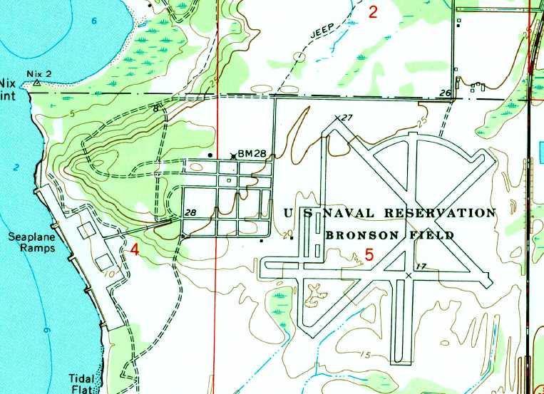
The 1970 USGS topo map depicted the "U.S Naval Reservation Bronson Field" as having 4 paved runways,
numerous taxiways, a street grid to the west of the airfield, and the seaplane ramp along the coast.
"OLF Bronson (Navy)" was still depicted as an active airfield
on the January 1976 New Orleans Sectional Chart (courtesy of Chris Kennedy).
Kevin Fitzpatrick recalled that "Back in the 1970s my Boy Scout troop used to camp [at Bronson] regularly.
There was some formal agreement at the time (1973-78) with the Gulf Coast Council
and very large regional camporees with thousands of scouts were held there.
By that time all of the buildings were gone but the foundations remained.
Also the tall water towers were still there & some of us were brave (stupid) enough to climb them.
The field was still used for touch & goes then by trainers.
The large round expanse of asphalt had deteriorated in the hot Florida sun by then
and was a huge open field of grass shoulder high.
I remember one day walking along the seaplane ramps on Perdido Bay
(previously one of the most polluted bodies of water in the US)
and seeing my first wild porpoise out in the bay."
The 1987 USGS topo map still depicted the "U.S Naval Reservation Bronson Field" as having 4 paved runways,
numerous taxiways, a street grid to the west of the airfield, and the seaplane ramp along the coast.

A sad sight - a 1987 photo by John Voss of an SNJ Texan fuselage, sitting forelorn at the former Bronson Field.
"There were a number of SNJ fuselages at Bronson... maybe a dozen, all in a neat row.
I also spotted numerous SNJ wings all stacked up like fallen dominos.
There was a wooden building in the immediate area that seemed to be full of aircraft parts as well.
My guess is that they were in storage for the Naval Air Museum at nearby Pensacola."
These were the remnants of the SNJs sold from this location in 1958.
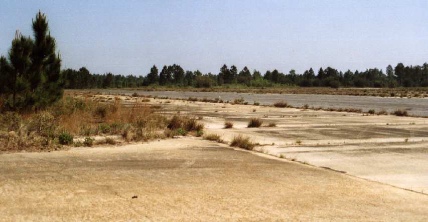
A 1987 photo by John Voss of the airfield pavement at Bronson Field.

A 1987 photo by John Voss of the seaplane ramp which remained largely intact at Bronson Field,
although the hangars had been demolished.
The runways at Bronson were still used as late as 1993 for practice landings by Navy helicopters.

The 1994 USGS topo map still depicted "Pensacola NAS OLF Bronson" as having 4 paved runways,
numerous taxiways, a street grid to the west of the airfield, and the seaplane ramp along the coast.

A 2004 aerial view of Bronson Field, with the seaplane ramp to the west of the large airfield.
Pictures from September 2004 (courtesy of Dallam Oliver-Lee) showed debris from Hurricane Ivan cleanup operations
being dumped on the Bronson Field pavement.
Bronson Field's runways have occasionally been reused for weekend automobile races.
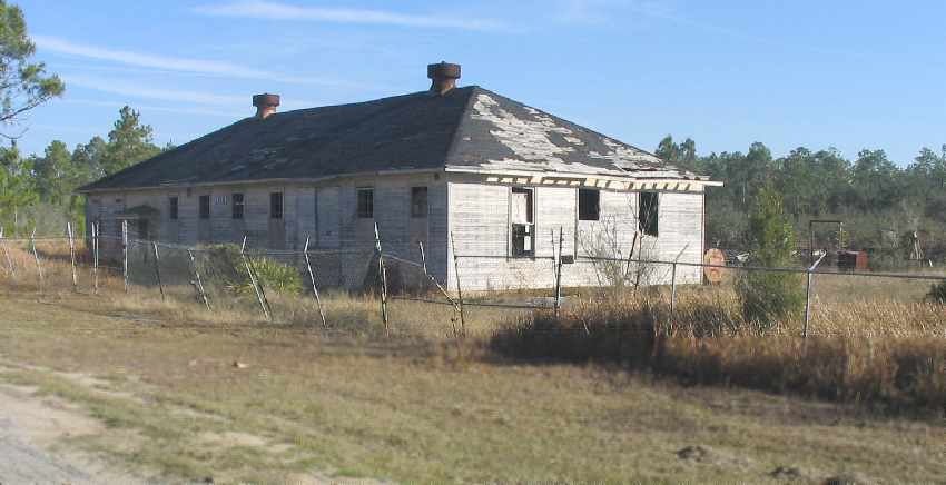
A January 2006 photo by Paul Freeman looking northeast at one of 2 wooden buildings which remain standing,
just northeast of the Bronson airfield.
These were the buildings which had been used for the sale of the surplus SNJs in 1958.
There was a variety of junk sitting scattered around the 2 buildings,
but there was no sign of the SNJ fuselages which had been photographed next to these buildings by John Voss in 1987.

A January 2006 photo by Paul Freeman looking south, showing a 2-story building on the western edge of the ramp.
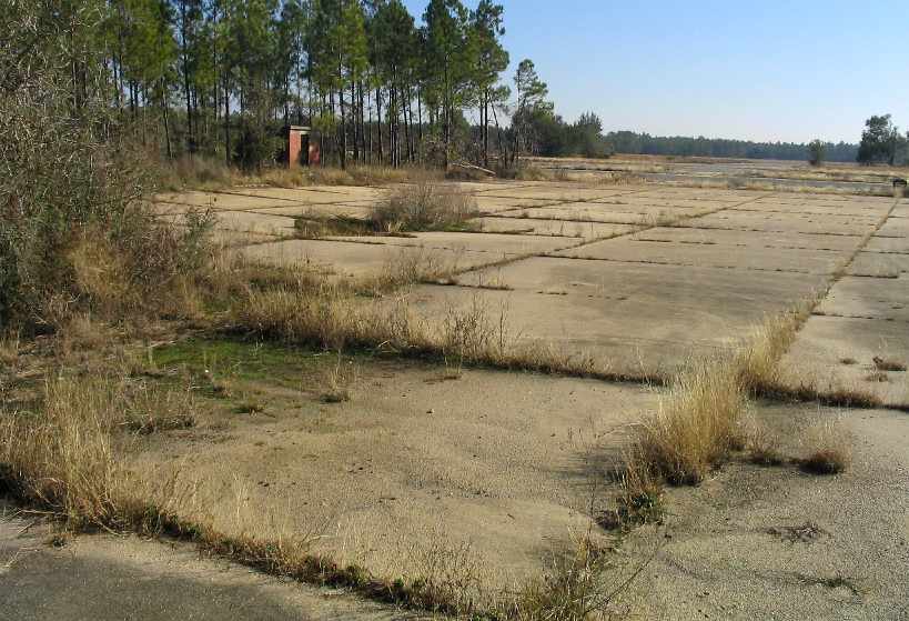
A January 2006 photo by Paul Freeman looking northeast,
showing a brick shack on the northwest side of the former ramp.

A January 2006 photo by Paul Freeman, looking east across the huge expanse of the former airfield.
Several large trucks were visible on the far (east) side of the airfield.
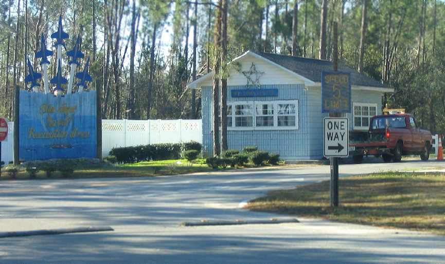
A January 2006 photo by Paul Freeman, looking southwest at the entrance to the “Blue Angel Naval Recreation Area”,
which occupies the site of the former seaplane area on the west side of the base.
A circa 2006-2007 aerial photo shows that the wooden building just north of the airfield
(previously photographed as late as January 2006) was burned down.

A circa 2006-2007 aerial view looking south shows the last runway markings which remain visible at Bronson Field, for Runway 13.

A circa 2006-2007 aerial photo looking north shows that the runway intersection
had been painted with “HC-16 Bullfrogs 1974-1994”.
The runway pavement on the southeast side of the airfield had been removed.

A 2/1/13 aerial view (courtesy of Dallam Oliver-Lee) showed the Bronson airfield to remain intact though deteriorated.
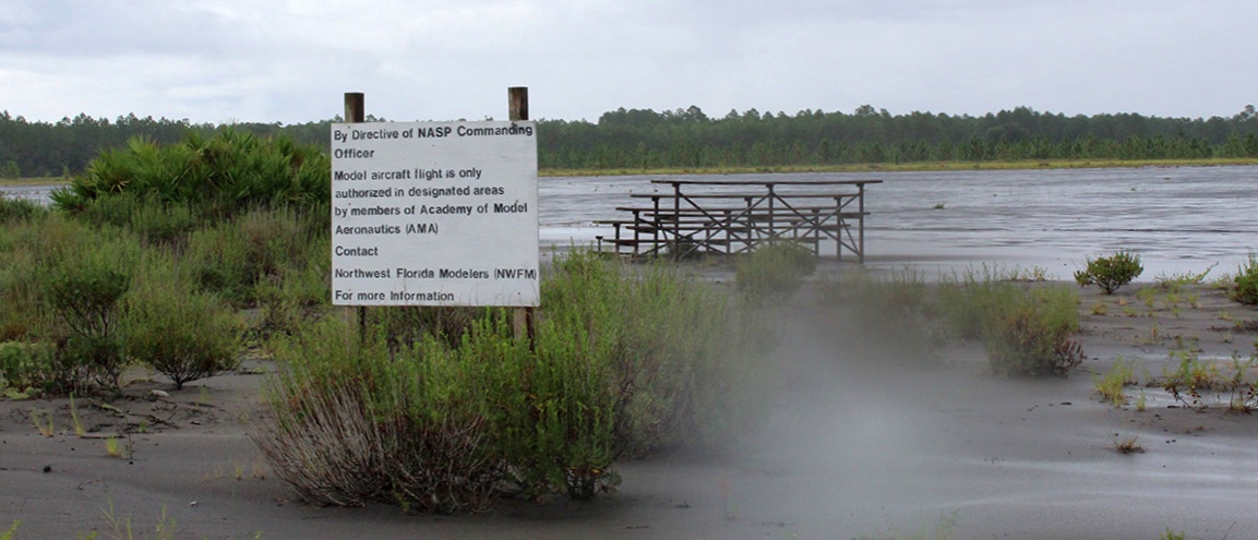
A 9/3/16 photo by Matt Franklin of the remains of the Bronson Field paved circle.
Matt reported, “They’ve pulled up half of the circle, but it is still a paved monstrosity in terms of sheer size of pavement.
The area where the trainers were flown off is completely overgrown with trees and you’ll likely get Zika from just looking at it.
Too bad the fuselages were gone, one could feel like Indiana Jones hacking their way through the forest to buried treasure.
The police seem to use it for vehicle training, but unlike The Police they do not watch every step you take nor every move you make, as it was abandoned on the day I visited.
The paved half-circle still sees aircraft of the Radio-Controlled variety, according to the sign.”
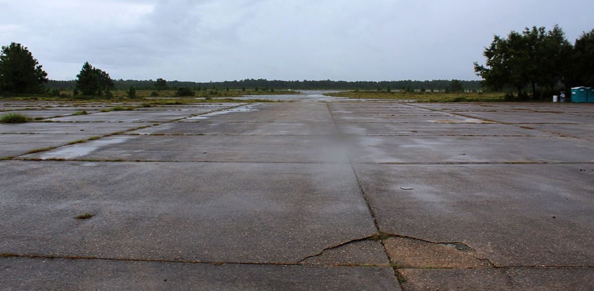
A 9/3/16 photo by Matt Franklin of the remains of the Bronson Field ramp.

A 9/3/16 photo by Matt Franklin of the remains of a Bronson Field taxiway.
See also: http://www.pafw.com/bronson.htm
____________________________________________________
Since this site was first put on the web in 1999, its popularity has grown tremendously.
That has caused it to often exceed bandwidth limitations
set by the company which I pay to host it on the web.
If the total quantity of material on this site is to continue to grow,
it will require ever-increasing funding to pay its expenses.
Therefore, I request financial contributions from site visitors,
to help defray the increasing costs of the site
and ensure that it continues to be available & to grow.
What would you pay for a good aviation magazine, or a good aviation book?
Please consider a donation of an equivalent amount, at the least.
This site is not supported by commercial advertising –
it is purely supported by donations.
If you enjoy the site, and would like to make a financial contribution,
you
may use a credit card via
![]() ,
using one of 2 methods:
,
using one of 2 methods:
To make a one-time donation of an amount of your choice:
Or you can sign up for a $10 monthly subscription to help support the site on an ongoing basis:
Or if you prefer to contact me directly concerning a contribution (for a mailing address to send a check),
please contact me at: paulandterryfreeman@gmail.com
If you enjoy this web site, please support it with a financial contribution.
please contact me at: paulandterryfreeman@gmail.com
If you enjoy this web site, please support it with a financial contribution.
____________________________________________________
This site covers airfields in all 50 states.