
Abandoned & Little-Known Airfields:
Northern Indiana
© 2002, © 2016 by Paul Freeman. Revised 10/31/16.
This site covers airfields in all 50 states: Click here for the site's main menu.
____________________________________________________
Please consider a financial contribution to support the continued growth & operation of this site.
Aretz Airport (revised 10/31/16) - Culver Airport / Fleet Field (revised 4/26/15) - Elwood Airport (revised 12/1/13)
Halsmer Airport (revised 10/31/16) - Michigan City Municipal (revised 8/27/16)
NOLF 11713 / Converse Airport (revised 8/27/16) - NOLF 23008 / Galveston Airport (revised 5/22/16)
____________________________________________________
Elwood Airport (3I1), Elwood, IN
40.25, -85.83 (Northeast of Indianapolis, IN)

Elwood Airport, as depicted on the 1960 USGS topo map.
According to an article in the 8/23/08 Herald Bulletin (courtesy of Mark Wright),
“Widely known as the world!s first fly-in drive-in, Elwood Airport was founded in 1946 by Don & Georgia Orbaugh of Elwood.
The airport offered sod runways for single-engine planes before gaining wider attention in 1952 when it opened an ice cream shack.
By 1953, a dining room was added to the shack & young girls wearing green uniforms with boxy green hats served customers on their planes.
The Orbaughs' daughters, Ann Brewer of Elwood & Donna Ewing of Anderson, now share ownership in the business.
Brewer said the airport was a labor of love for her father, who was a pilot & flight instructor.
Flying became popular in the 1940s, Brewer noted.
When the war ended, others sought flight instruction, and Elwood's unique restaurant & airport became a popular destination for those with miles to burn.
While Orbaugh loved the facility more than anyone, Brewer said, the dedication of area residents to the airport was shown in 1948.”
Ann Bewer recalled, “A tornado blew down the hangar, the only hangar at that time,
and the pilots & some of the farmers around helped my dad rebuild it.
He said he would never have been able to continue if they hadn't pitched in & helped.”
The earliest depiction which has been located of Elwood Airport was on the 1960 USGS topo map.
It depicted the field as having at least 1 unpaved runway, with several buildings along the northwest side.

An undated (circa 1950s?) colorized photo of a waitress serving food to a group in a Bonanza
at the “World's First Fly-In Drive-In, Elwood, IN” (courtesy of Ray Johnson).
Ray Johnson recalled, “I flew out of Elwood Airport for years.
There was a well known mechanic who worked out of there & for Don Orbaugh for 50 years, Jim Howren, an excellent mechanic.
At one time Don Orbaugh was a Aeronca dealer.”

The only photo which has been located showing an aircraft at Elwood Airport was an undated photo of Mark Wright & his Cessna 152
in front of Elwood Airport's restaurant, with the sign proclaiming “Welcome World's First Fly-In Drive-In.”
Mark recalled, “I just flew in once for a hamburger. It was a neat little field!”
According to an article in the 8/23/08 Herald Bulletin (courtesy of Mark Wright),
“One glance at the smudged, tattered postcard and it's obvious that the Elwood Airport, closing September 1,
is more than just another local business lost to economic misfortune.
The postcard has kept bold colors in spite of its age.
The image clearly displays a carhop waitress kneeling on the wing of an old airplane.
She is serving drinks on a white tray to a pilot & his passengers.
For some, the airport's closing marks the end of an era where the skies were highways.
Back then, Elwood provided the only one-stop shop for ordering drive-in food from the jump seat.
The airport is slated to shut down but its iconic restaurant will remain open.
The airport has not been profitable, said airport co-owner Ann Brewer.
If it weren't for the restaurant & surrounding crops, it would have closed long ago, Brewer said.”
Mark Wright reported in 2010, “Elwood Airport... I drove by it today & realized it was closed.
The airport restaurant is still open. The grass runways have been plowed over.”
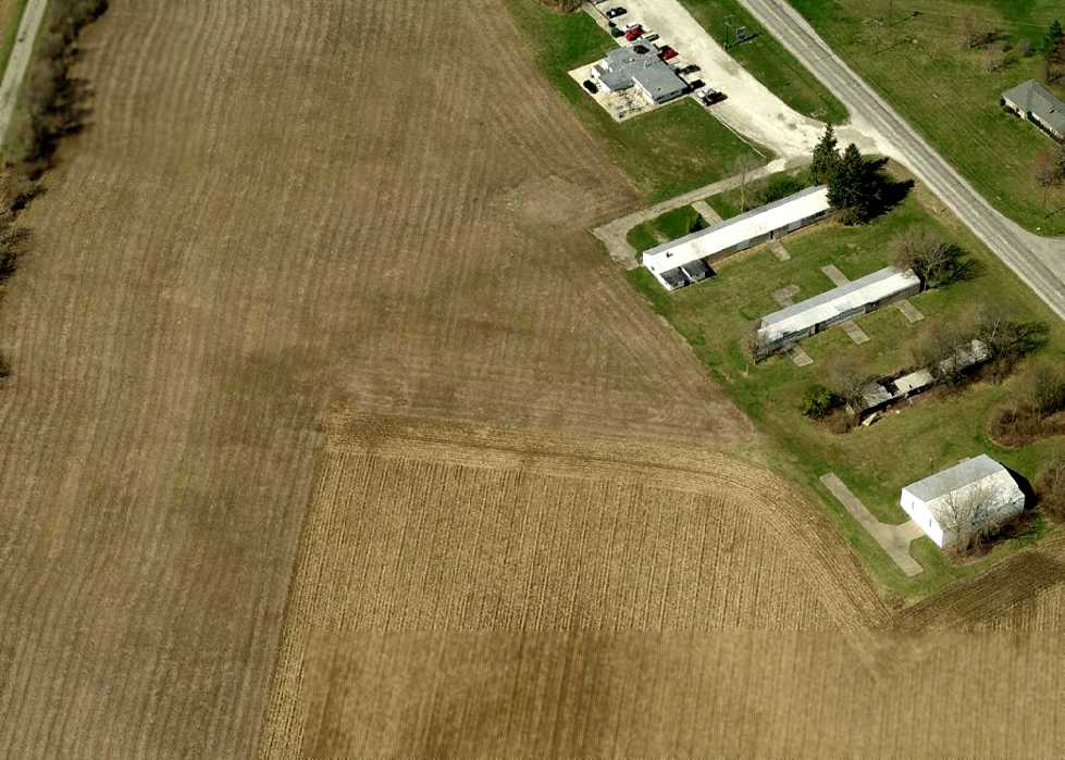
A circa 2005-2011 aerial view looking west at hangars & the airport restaurant at Elwood Airport.
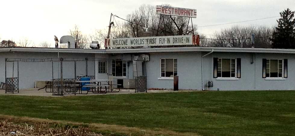
An 11/4/12 photo by Tom Townsend of the Elwood Airport restaurant.
Tom Townsend reported, “I visited the former Elwood Airport on 11/4/12.
The lady at the restaurant (good food & great prices!) told us that Don, the old owner, was told by the EPA to replace the fuel tanks in the ground.
He could not afford to do so & removed them. Without fuel, few aircraft came to the field.
The owner died & left the field to his 2 daughters.
They leased the land where the runways were situated to a local farmer, who has since planted them in crops.
Remaining buildings are the restaurant, the shop & 3 hangars, only one of which is a serviceable building, the other 2 in states of decay.”

An 11/4/12 photo by Tom Townsend, “Looking in the window of the shop. Note the aviation radios on the desk.”

An 11/4/12 photo by Tom Townsend, of the “Site of the runways.”
The site of Elwood Airport is located northeast of the intersection of Route 37 & Airport Road, appropriately enough.
____________________________________________________
Culver Airport / Fleet Field, Culver, IN
41.22, -86.39 (North of Indianapolis, IN)

Culver Airport, as depicted on the 1962 USGS topo map.
This small airport was located adjacent to the Culver Military Academy.
The date of establishment of Culver Airport has not been determined.
James Bean recalled, “The Academy has photos of aircraft using the field in the 1920s & 1930s.”
But Culver Airport was not yet listed among active airfields in the 1945 AAF Airfield Directory (courtesy of Scott Murdock).
The earliest depiction which has been located of Culver Airport was on the 1962 USGS topo map.
It depicted the field as having 2 unpaved runways, with no buildings.
According to Rich Dugger, “Located next to Culver Military Academy,
they had a flight training operation out of there mostly to Mexican students that came up for the summer sessions.
I knew the Chief Flight Instructor & also the mechanic doing maintenance on the fleet of Cherokee 140s.
Oddly enough the mechanic was the son of Joe Phillips of the Joe Philips Airport in Michigan City.”
James Bean recalled, “I was a summer school cadet of the aviation squadron, from 1973-75 & flew from Fleet for 3 summers.
In 1973 both runways were grass, and we had 3 Cherokee 140 Fight Liners (FL) for training.
The aviation summer program started in 1973.
The north/south runway was paved in 1974 & they had 5 Cherokees: three 140s & two 151 Warriors.
I graduated as Executive Officer (2nd In Command) in the summer of 1975, and had my Private Pilot Airman Certificate by August 15th.
Great experience & wonderful memories.”

The 1991 USGS topo map shows that Culver's northwest/southeast runway was evidently paved at some point between 1962-91.

The earliest photo which has been located of Culver Airport was a 4/28/98 USGS aerial view looking northwest,
which showed one single-engine aircraft on the ramp next to the hangar.
A 7/13/03 aerial view depicted 3 single-engine aircraft on the ramp at Culver Airport.
According to Rich Dugger, “A flight instructor & a student both drowned after an engine failure shortly after takeoff.
I’ll never understand why it went into the water.
Shortly afterwards we flew over it & saw the Xs on the runway & that was the end of the flying out of Culver Airport.”
A 9/2/05 aerial view showed the Culver runway still marked as operational,
but no aircraft were visible on the field.
According to Jordan Chastain, “The airfield there closed around 2005.”
A 7/27/06 showed a closed-runway X having been painted on each end of Culver's Runway 16/34.
An 8/13/07 aerial view showed Culver Airport to remain intact.
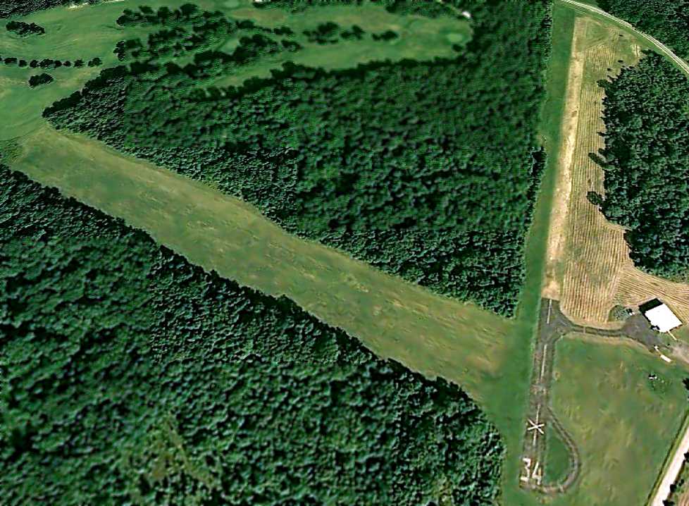
The last photo which has been located of Culver Airport was a 6/19/08 aerial view looking northwest.
The majority of the pavement of Runway 16/34 had evidently been removed at some point within the previous year.
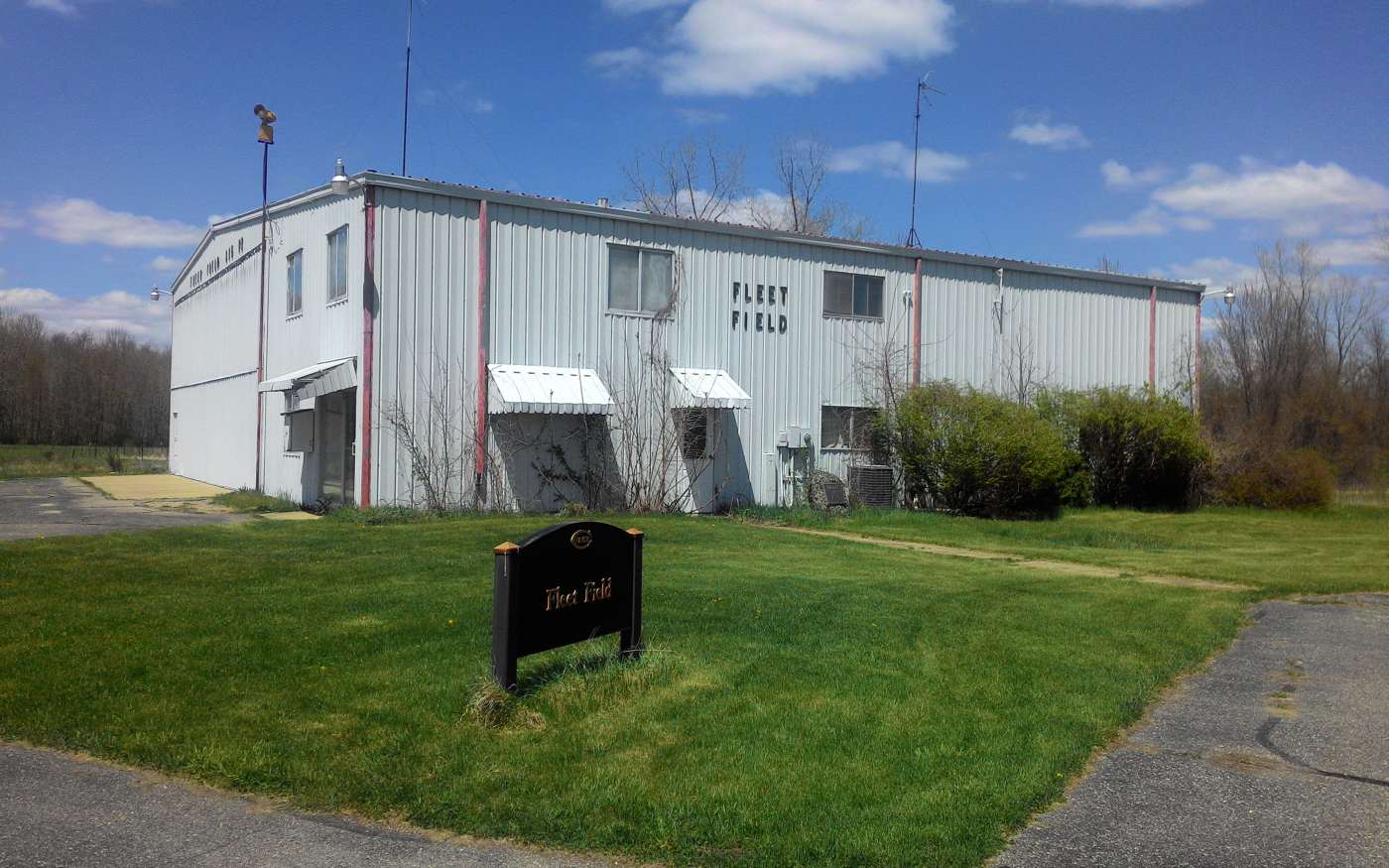
A 4/26/15 photo by Daniel Cheung of the Fleet Field hangar, which appears to remain in fine condition.

A 4/26/15 photo by Daniel Cheung of a phone box outside the Fleet Field hangar. Daniel observed remarkably, “It still has a dial tone.”
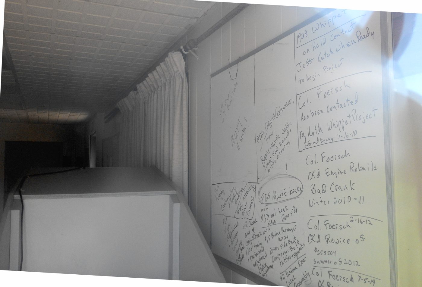
A 4/26/15 photo by Daniel Cheung of the whiteboard which remains inside the Fleet Field hangar.

A 4/26/15 photo by Daniel Cheung of a Fleet Field runway, now reused for soccer fields.

A 4/26/15 photo by Daniel Cheung of the Fleet Field wind direction indicator.
Fleet Field is located southwest of the intersection of Route 10 & Queen Road.
____________________________________________________
Michigan City Municipal Airport (C39), Michigan City, IN
41.67, -86.89 (Southeast of Chicago, IL)
Michigan City Municipal Airport, as depicted on the 1961 Chicago Sectional Chart (courtesy of Chris Kennedy).
This general aviation airport was located on the south side of the town of Michigan City.
It is not to be confused with the similarly-named Michigan City Airport,
which is located on the east side of the town.
Michigan City Municipal Airport was not depicted at all on the 1946 Chicago Sectional chart (courtesy of Chris Kennedy).
According to Russ, "The American Air Mail Society Catalogue lists an airport dedication cover
for Michigan City Municipal for 10/11/48… probably its official opening date."
The earliest chart depiction of Michigan City Municipal Airport which has been located
was on the 1961 Chicago Sectional Chart (courtesy of Chris Kennedy).
It depicted the field as having a single 2,200' paved runway.
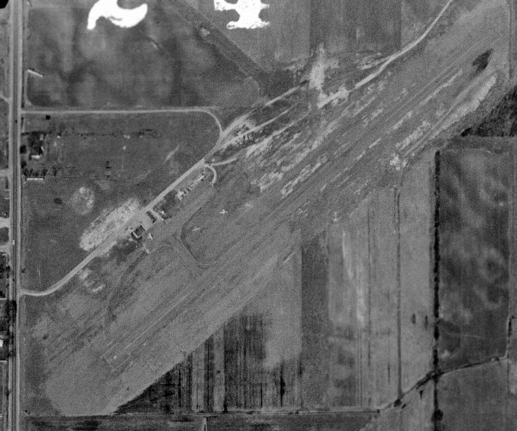
A 3/1/61 USGS aerial photo depicted Michigan City Municipal Airport
as having a single northeast/southwest paved runway, and 5 light aircraft parked amongst some small buildings on the northwest side.
The 1962 AOPA Airport Directory described Michigan City Municipal Airport
as having a single 2,200' bituminous Runway 4/22,
and listed the operator as the Board of Aviation Commissioners.
Michigan City Municipal Airport, as depicted on the 1969 Chicago Sectional Chart (courtesy of John Voss).
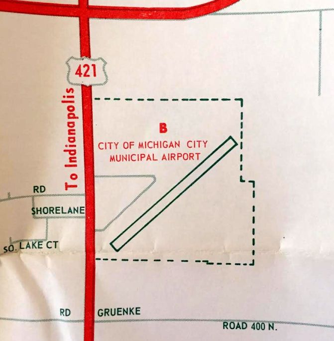
A 1969 road map (courtesy of Kevin Walsh) depicted “City of Michigan City Municipal Airport”
as having a single northeast/southwest paved runway.
The 1980 USGS topo map depicted the field as having a small paved ramp
with several hangars on the west side of the runway.
By the time of the 1982 AOPA Airport Directory (courtesy of Ed Drury),
Michigan City Municipal Airport was described as having a 2,400' asphalt Runway 5/23.
The operator was listed as Lake Air Corporation.
According to Rich Dugger, “I used to fly out of there some & knew the manager although not very well.
Michigan City Municipal Airport was closed shortly after the manager, also the owner of the FBO,
disappeared in an airplane crash in South America before 1991.
The city was happy to see him go & used that as a reason to close the airport
and put all their resources into what was Joe Phillips Airport, now Michigan City Municipal.”
The 1998 USGS aerial photo shows that the site of Michigan City Municipal Airport
had been obliterated by the construction of a large building over the middle of the property.
The outline of the former runway can still be barely recognized on either side of the new building.
Other than that, not a trace remains of the former airport.
Dick McCloskey reported in 2005, “The site of Michigan City Municipal Airport is now a shopping mall.”
According to Rich Dugger, “What was the airport hangars is now a Lowe’s & where the runway was is now a Menard’s.”
The site of Michigan City Municipal Airport is located northeast of the intersection of Route 421 & East Kieffer Road.
____________________________________________________
Aretz Airport (3AR), Lafayette, IN
40.46, -86.837 (Northwest of Indianapolis, IN)
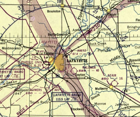
Aretz Airport, as depicted on the November 1950 Chicago Sectional Chart.
Aretz Airport was apparently opened at some point between 1946-53,
as it was not yet depicted on the June 1946 Chicago Sectional Chart.
The earliest depiction which has been located of Aretz Airport was on the November 1950 Chicago Sectional Chart.
It depicted Aretz as having a 3,200' unpaved runway.

The 1960 Jeppesen Airway Manual (courtesy of Chris Kennedy)
depicted Aretz as having 2 unpaved 3,000' runways (7/25 & 11/29),
along with a cluster of small buildings on the west side of the field.
In the 1962 AOPA Airport Directory,
Aretz Airport was described as having two 3,000' turf runways (4/22 & 14/32),
and the operator was listed as Aretz Flying Service.
Deborah King recalled, “I was a very young (18) student pilot while learning to fly at Purdue Field.
The last part of my flight instruction was at Aretz Field, in the fall & early winter of 1968.
The runway was paved then, but I recall a lot of mud at the field, enough that I couldn't complete my instruction there.
My flight instructor was Lyle Holbo.”
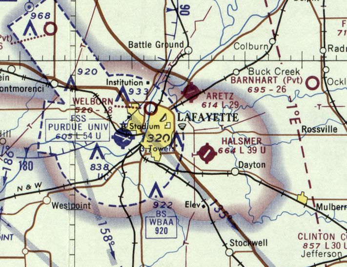
The last aeronautical chart depiction which has been located of Aretz Airport was on the May 1970 Chicago Sectional Chart.
Aretz had evidently gained a paved runway at some point between 1960-70,
as it was depicted as having a paved 2,900' northeast/southwest runway.
By the time of the 1982 AOPA Airport Directory (courtesy of Ed Drury),
Aretz had a 2,800' asphalt Runway 7/25 & a 2,900' turf Runway 11/29.
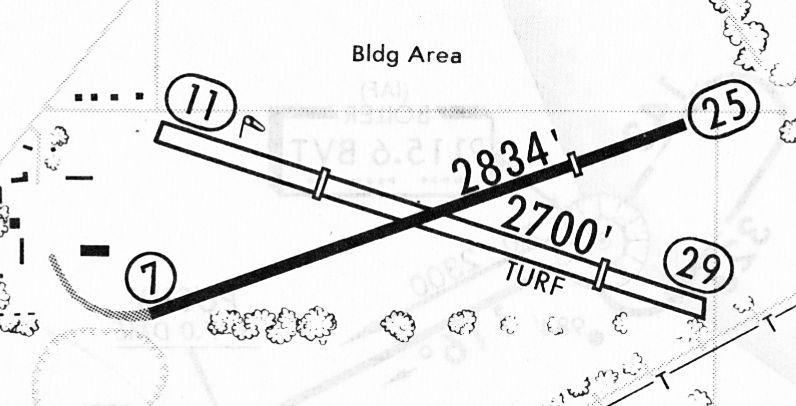
A 2/11/83 airport directory (courtesy of John Kielhofer)
depicted Aretz Airport as having a 2,834' paved Runway 7/25 & a 2,700' turf Runway 11/29,
along with several buildings along the west side of the field.
Mark Bailey instructed for Ruth Aretz from 1987-91.
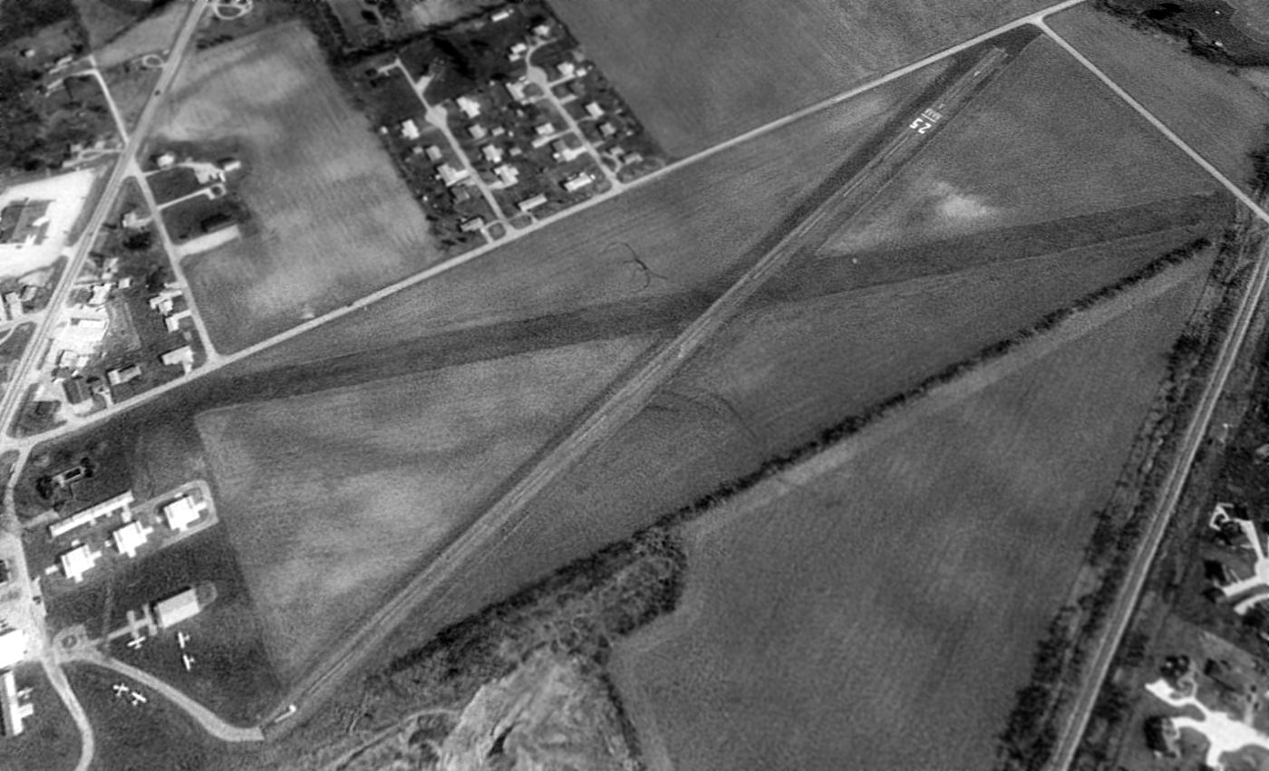
The earliest photo which has been located of Aretz Airport was a 1992 USGS aerial view looking northeast.
Aretz was shown to have a paved Runway 7/25 & a grass crosswind runway.
Five light single-engine aircraft were visible parked on the southwest side amidst several small hangars.
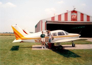
A 1995 photo by John Clear of a Piper Warrior in front of a hangar at Aretz Airport.
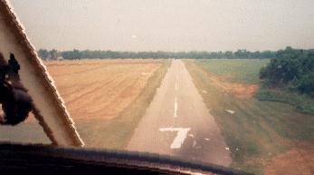
A 1995 photo by John Clear on final approach to Artez's Runway 7.
John Clear recalled, "I flew out of Artez from 1991-96.
The identifier was 3AR until sometime after I left & it was changed to IN## (don't recall what it was).
In addition to the Artez flight school,
it was also home to Purdue Pilots, the Purdue flight club
(which is different from the Purdue aviation program at LAF)."
Aretz closed as a public-use airport in about 1997, and became a private field.
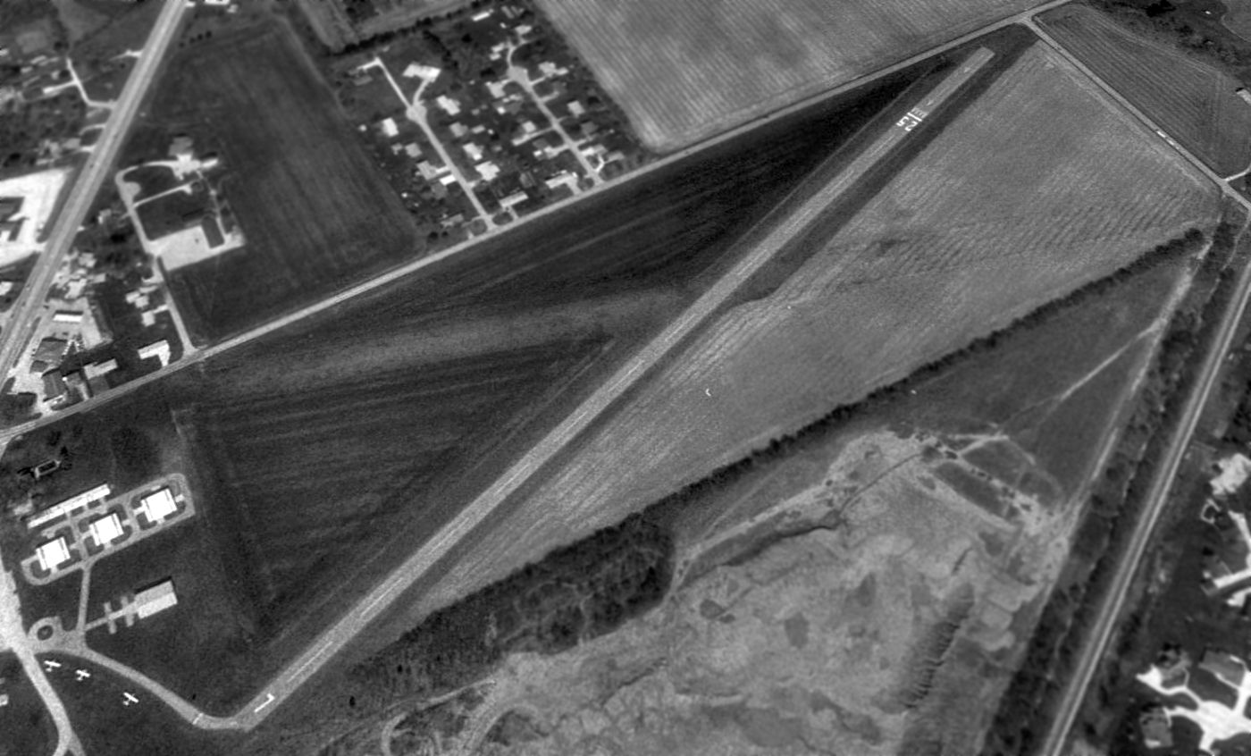
The last photo which has been located showing aircraft at Aretz Airport was a 1998 USGS aerial view looking northeast.
The number of aircraft visible on the field had decreased to 3,
and the grass crosswind runway appeared to no longer be maintained.
Aretz Airport closed at some point between 1999-2002.
It was no longer depicted at all (even as an abandoned airfield) on 2002 aeronautical charts.
As an aside, Terry Aretz pointed out that the closing of Aretz Airport
was noted by Paul Harvey on his national radio show as a sad day for private aviation.
According to Terry Aretz (a relative of the owner of Aretz Airport), after the airport owner retired,
she tried to sell the property as an airport, but was not successful.
She eventually sold the land to a non-aviation business.
In Terry's words, "Tough times for small airports anymore."
Aerial photos from 2003 & 2004 showed Aretz Airport remained intact, but no aircraft were visible on the field.
A 2005 aerial view showed the construction of a large building adjacent to the midpoint of the runway.
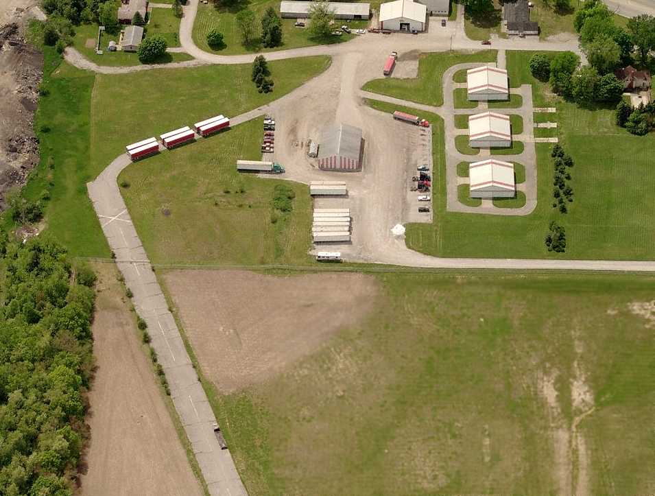
A circa 2006 aerial view looking west at the hangars & runway which remain at the site of Aretz Airport.
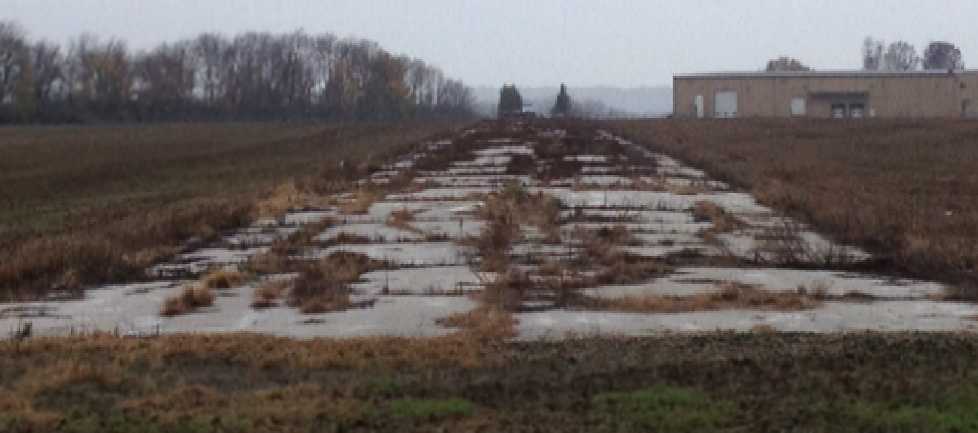
A sad October 2012 photo by Tom Townsend looking along the remains of the Aretz runway, showing this aviation infrastructure going to waste.
Tom remarked, “The runway is breaking up.”
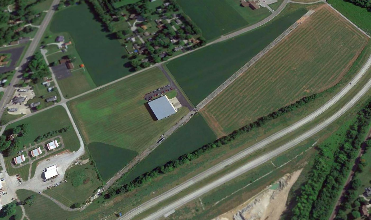
A 2015 aerial view looking northeast at the site of Aretz Airport showed the paved runway & several hangars remained intact.
Aretz Airport is located southeast of the intersection of Route 25 & E 300 N.
____________________________________________________
Halsmer Airport (3HM), Lafayette, IN
40.39 North / 86.8 West (Northwest of Indianapolis, IN)

A circa 1943-45 aerial view looking east at Halsmer Airport
from the 1945 AAF Airfield Directory (courtesy of Scott Murdock).
As described on the 1988 Indiana Aeronautical Chart,
Halsmer Airport was the result of a dream of three brothers who became hooked on aviation after a trip to an air show in 1927.
Frances, John and Joseph Halsmer built their 1st planes in 1931,
and taught themselves how to fly on their father's dairy farm,
which soon became Halsmer's Airport.
While all 3 Halsmer brothers taught flying, they also performed additional managerial, inspection, and licensing duties.
During WW2 the Halsmer Brothers served in the AAF
but returned soon after to form Halsmer Flying Service where they continued giving lessons and flying charters.
The earliest depiction which has been located of Halsmer Airport
was a circa 1943-45 aerial view from the 1945 AAF Airfield Directory (courtesy of Scott Murdock).
It depicted the field as being a rectangular grass area with a few buildings & several light aircraft on the west side.
The 1945 AAF Airfield Directory (courtesy of Scott Murdock) described Halsmer Airport
as a 42 acre rectangular property within which were 2 sod 1,970' runways, oriented northeast/southwest & northwest/southeast.
The field was said to have a single 75' x 40' wood hangar,
and to be owned & operated by private interests.

The earliest aeronautical chart depiction which has been located of Halsmer Airport
was on the 1946 Chicago Sectional Chart (courtesy of Chris Kennedy).

The November 1950 Chicago Sectional Chart depicted Halsmer Airport as having a 4,000' unpaved runway.
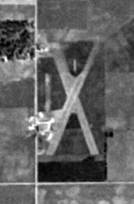
A 9/28/52 USGS aerial view depicted Halsmer Airport as having 2 unpaved runways.
The 1953 Flight Chart (courtesy of Scott O'Donnell) described Halsmer Airport as having a 4,000' runway.
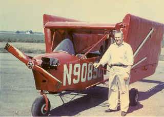
Joseph Halsmer turned the airport into his personal workshop where he invented the Aero Car,
the Halsmer Safety Twin, and a push-pull airplane with fore & aft propellers.
He also claimed several records, including one for the fastest turbo-prop trans-Atlantic flight.
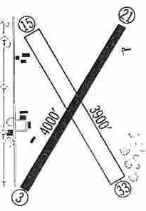
The 1960 Jeppesen Airway Manual (courtesy of Chris Kennedy)
depicted Halsmer as having a 4,000' paved Runway 3/21 & a 3,900' unpaved Runway 15/33,
along with several buildings along the west side of the field.
In the 1962 AOPA Airport Directory,
Halsmer Airport was described as having a 4,000' paved Runway 4/22 & a 3,900' turf Runway 13/31.
The operator was listed as Halsmer Flying Service.
Deborah King recalled, “Halsmer Airport had an active sailplane flying club.
I used to ride with either the tow pilot in a Super Cub, or in the Schweitzer 2-22.
The tow pilot was quite young, looked like a typical long-hair hippie of the late 1960s, and was actually a very skilled pilot.
You never would have guessed it by his appearance!”
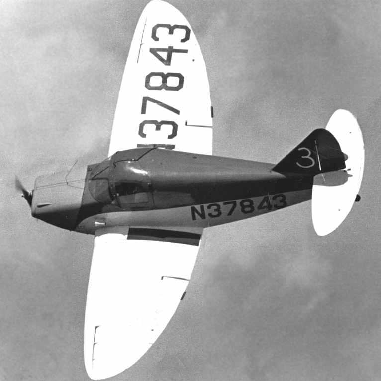
A 1968 photo (courtesy of Bill Poynter) of Bill's Culver Cadet rounding a pylon during a pylon race for stock planes held at the Halsmer Airport.
Bill recalled, “I responded to a notice posted in Trade-A-Plane, and signed up to race.
There were 2 classes, one for planes with less than 100 HP & one for planes with over 100 HP.
The plane I had at the time was a Culver Cadet, which I figured would be competitive in the under 100 HP class.
The qualifying was on August 18, 1968 with the races on August 24th & 25th, 1968.
None of the entrants had ever participated in a pylon race before. It was pretty scary.
A Mooney Mite with an 85HP engine came in 1st & I was 2nd in my Culver.”

An advertisement for the 1968 air races held at Halsmer Airport (courtesy of Bill Poynter).
Note that the airplanes depicted in the advertisement were just a little bit more futuristic than the actual race planes!

The last aeronautical chart depiction which has been located of Halmser Airport was on the May 1970 Chicago Sectional Chart.
Halsmer was depicted as having a paved 3,900' northeast/southwest runway.
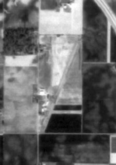
The last photo which has been located showing Halsmer Airport still open was an 11/8/76 USGS aerial view.
Only 1 runway was still active, with only traces of the northwest/southeast runway still visible.
The 1982 AOPA Airport Directory (courtesy of Ed Drury)
described Halsmer as having a single 3,950' asphalt Runway 2/20.
The airfield status had also changed to a private facility, with the note, "Use at own risk."

A 2/24/84 airport directory (courtesy of John Kielhofer)
depicted Halsmer as having a 3,873' paved Runway 2/20 & a 1,365' turf ultralight Runway 18/36,
along with several buildings along the west side of the field.
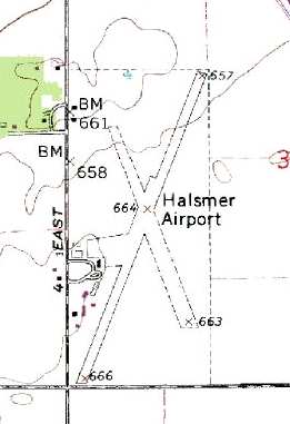
USGS topo map 1987.
According to USAF Lt. Col. Mark Bailey,
"Halsmer closed in about 1988-90 to make room for the Subaru auto plant."
However, it was actually an adjacent site (to the south) on which the auto plant was built.
In the 1999 USGS aerial photo,
the entire length of the primary runway still remained, but was considerably deteriorated.
The airfield buildings had been removed from the former ramp area, southwest of the runway.

As seen in a 2006 aerial photo,
the majority of the pavement of the center portion of the former Runway 3/21 still remained,
although the north & south ends had been removed.
The former ramp area also remained as well.
A building was built at some point between 1999-2006 at the north end of the runway.

A circa 2006 aerial view looking north showed the remains of of the Halsmer Airport runway,
as well as the remains of the paved ramp.

A 6/13/15 aerial view by Rob Blue looking west showed the remains of of the Halsmer Airport runway.
The site of Halsmer Airport is located northeast of the intersection of E 200 S & S 500 E,
just southwest of Interstate 65.
See also: http://www.blueskygirl.com/Crazy8/Crazy8/Bio/history2.html
____________________________________________________
Bunker Hill Outlying Field #8 / Naval Outlying Field 11713 /
Converse Airport (1I8), Converse, IN
40.57, -85.89 (North of Indianapolis, IN)

A 7/24/42 land acquisition map of “Auxiliary Landing Field #8” (National Archives, courtesy of Brian Rehwinkel).
This airfield was evidently constructed during WW2 as one of the 26 satellite airfields for Bunker Hill NAS
(which later became Grissom ARB), located a few miles to the northwest.
The date of construction of the airfield has not been determined.
No airfield at Converse was listed in the 1935 Air Pilots Register (courtesy of Michael Banks).
According to Brian Rehwinkel, this “site was leased for use as an outlying field for NAS Bunker Hill in mid 1942.
The site consisted of approximately 250 acres.”
The earliest depiction which has been located of Outlying Field 11713
was a 7/24/42 land acquisition map of “Auxiliary Landing Field #8” (National Archives, courtesy of Brian Rehwinkel).
It depicted the field as a concrete octagon, measuring a maximum of 1,800' across, with no buildings.
This would appear to be the ideal airport layout -
permitting landings in any direction - never a crosswind!
According to a January 1944 Navy memo, the concrete mat, with an 1,800’ all-way landing surface,
was added in the fall of 1943 at a cost of $492,546.
According to Brian Rehwinkel, “This was a rather unusual procedure for an Outlying Field
because the Navy made substantial improvements on land it did not own.
During WWII, the Navy generally owned the Outlying Fields
where substantial improvements were made such as concrete or asphalt surfaces.
For the many grass outlying fields, the Navy would simply lease the land & cancel the lease at the end of the war.”
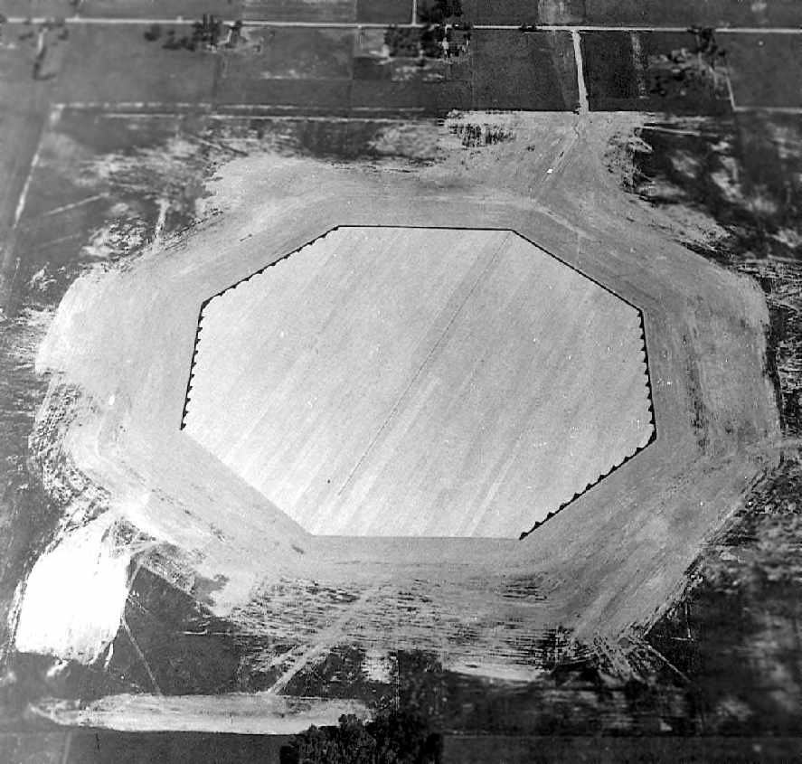
The earliest photo which has been located of Outlying Field 11713
was a September 1943 aerial view looking north at the newly-constructed field (National Archives photo, courtesy of Brian Rehwinkel).
It depicted the field as a paved octagon, with no buildings.
According to Brian Rehwinkel, “The Navy eventually acquired the site (250 acres) through condemnation proceedings in early 1944.
One of the reasons given for the necessity of purchasing the property
was that it would cost the Navy less to buy the land for this field (and for Field 23008/Site 3)
than it would to remove the improvements before the leases were terminated.”
A 11/19/43 aerial view from the 1945 AAF Airfield Directory (courtesy of Scott Murdock)
depicted “Bunker Hill NAS Auxiliary (11713 Outlying Field #8)” as a paved octagon,
with no buildings visible.
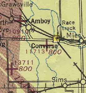
The earliest aeronautical chart depiction which has been located of Outlying Field 11713
was on the October 1944 Chicago Sectional Chart (courtesy of Chris Kennedy).
It depicted "11713" as an auxiliary airfield.
The 1945 AAF Airfield Directory (courtesy of Scott Murdock) described “Bunker Hill NAS Auxiliary (11713 Outlying Field #8)”
as a 244 acre irregularly-shaped property within which was a 3,302' x 2,392' sod all-way field
containing a 1,800' nonreinforced concrete octagonal landing mat.
The field was not said to have any hangars,
to be owned by the U.S. Government, and operated by the Navy.
Outlying Field 11713 was apparently abandoned by the military at some point between 1945-46
(like the vast majority of the WW2 auxiliary airfields),
as it was not depicted at all on the 1946 Chicago Sectional Chart (courtesy of Chris Kennedy).
According to a 1947 War Assets Administration memo,
the 250 acre site was declared surplus by the Navy in 1947
and conveyed to the Town of Converse via quitclaim deed in November 1947.
The deed contained provisions that the town would continue to maintain the installation as a public airport.
At some point between 1947-53, it was reopened as a civilian airfield - Converse Airport.
The earliest depiction of Converse which has been located is on the 1953 Flight Chart (courtesy of Scott O'Donnell),
which depicted it as a civil airfield with a 1,600' hard surfaced landing area.
The 1962 AOPA Airport Directory described the runway configuration as "all-way landings, 52 acre concrete slab",
but included the note, "Emergency use only."
Dave Greene recalled in 2004, "I have many fond memories of my father Pat & I going there
so he could fly his model airplanes.
They even had some major regional model airplane shows there in the 1970s.
I don't ever actually recall seeing a real airplane there, but the RC guys were then allowed to use it.
When I was there in the 1970's there was an old small wood building (large shed basically), but nothing else,
the Octagon was barren, not a building on it.
Those 2 buildings went up sometime in the late 1980's I think,
and I am pretty sure they are hangars, as there is now some activity there by private pilots.
Paul Ruley recalled, "Converse is where I taught [Pat Greene] his short field take-off & landings when he was my student.
It gives the student more appreciation of just what I am having him to accomplish.
The pad is not a true 360º airport.
There is a drainage tile running north & south through the field
and is covered with wood blocks spaced a distance apart.
The aircraft could cross it, but you would want a wheel running along it as it would tend to jar your fillings loose."

A 1998 USGS aerial view looking north showed a postwar runway painted across the concrete landing pad at Converse.
The airfield is still used as a general aviation airport, Converse Airport.
Published data in the Airport Facility Directory indicates that 5 aircraft are currently based at the field.
Max Reed (local resident & former Grissom AFB pilot) reported in 2007, “The Converse field remains in use
and was referred to in the PBS special about the attempts to fly replicas of the Wright Brothers original plane
in celebration of the 100 -year anniversary of the 1st flight.
A man named Buford Gross from Peru had built a Wright Flyer
and was wanting to prove it airworthy but had trouble getting permission from the FAA to do so.
At the last minute, some friends helped him take it out to Converse
and he attempted to get it off the ground but didn't have enough power.
Other groups were more successful, but fudged a bit with modern powerplants.
Buford's was a hand-built replica of the actual Wright Brothers engine.”

A 2007 photo by Patrick Long looking out across the concrete landing pad at Converse.
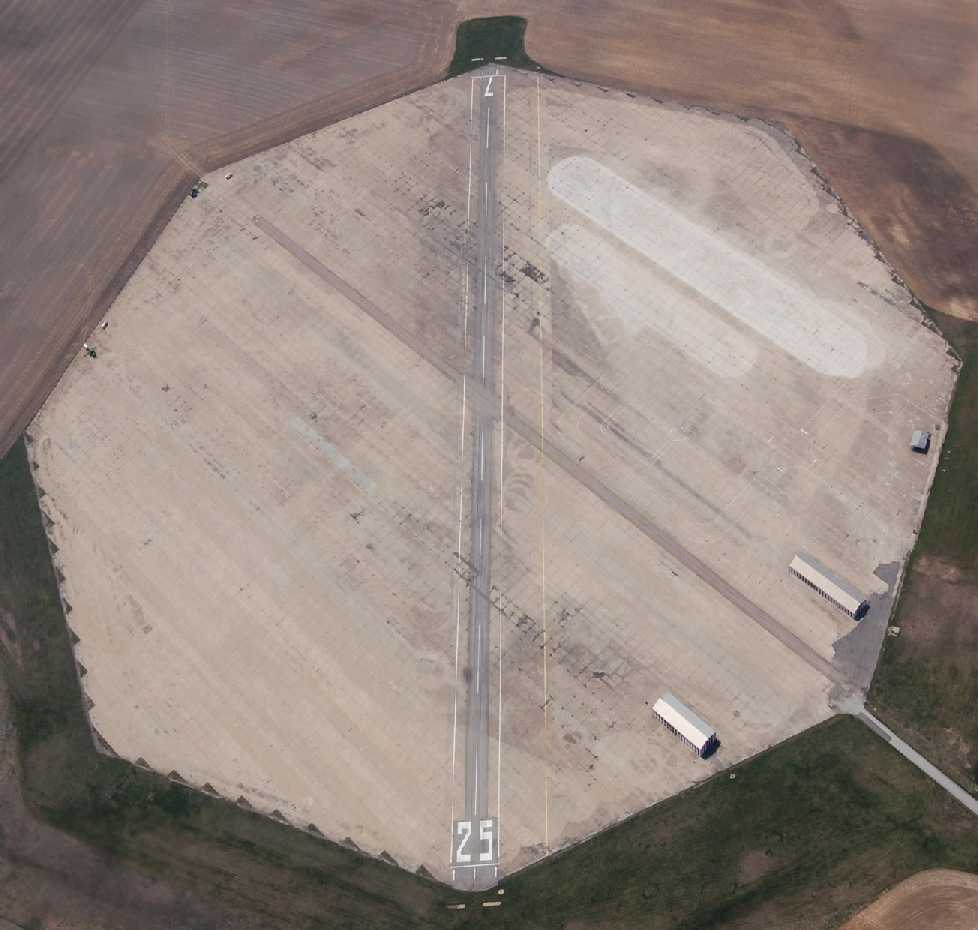
A 2010 aerial view by Bob McKenzie looking southwest at Converse Airport.

A 2010 aerial view by Bob McKenzie on final approach to Converse Airport.
Bob reported, “Converse was in much better condition than we expected.
The runway is well maintained & we landed our 182 without difficulty.
The airport is relatively deserted, but there are 6-8 T-hangars in excellent repair - all are secured & appear to contain aircraft.
An RC club uses a groomed portion of the field adjacent to the airport.
The RC club has a picnic shelter & several tables set up.”

A 2010 photo by Bob McKenzie of the sign for the Converse Airport & Industrial Park, “Home of the Converse Flying Eagles”.

An 11/4/12 photo by Tom Townsend looking along Converse's Runway 25. Tom reported, “The octagonal pad is still there & in pretty good shape.”
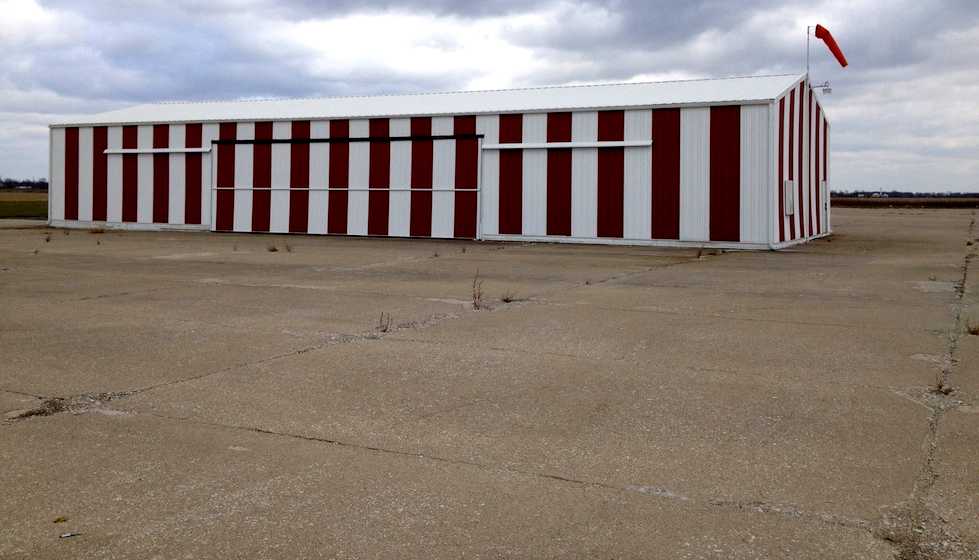
An 11/4/12 photo by Tom Townsend of “The east building at the airfield.”

A 2014 aerial view looking north showed a postwar runway painted across the concrete landing pad at Converse.
There is another nearby auxiliary field with the same configuration at Galveston, IN (see entry below).
Thanks to Roger Johnson for pointing out this airfield.
____________________________________________________
Bunker Hill Outlying Field #3 / Naval Outlying Field 23008 /
Galveston Airport (5I6), Galveston, IN
40.586, -86.252 (North of Indianapolis, IN)

An 8/6/43 U.S. Navy aerial view looking north at Field # 23008 during the construction of its landing mat (from the National Archives, courtesy of Brian Rehwinkel).
Brian Rehwinkel reported, “This field was one of the 19 or so outlying fields
leased for use by Naval Reserve Aviation Base (NRAB) Peru [located a few miles to the northeast, and later to be redesignated NAS Bunker Hill].
The field was first leased in mid 1942 (late spring or early summer).
The Navy leased 274 acres from several landowners for about $4,500 / year.
Field # 23008 (#3), along with Field # 11713 (#8) were two of the Bunker Hill fields chosen by the Navy to received hard-surface runways.
The Navy had concerns when the fields were first leased about the effect the weather would have on the continuous use of these fields.
However, it was not until fall 1943 that these 2 fields received hard-surface runways.”
The earliest depiction which has been located of the Galveston airfield
was an 8/6/43 U.S. Navy aerial view looking north at Field # 23008 during the construction of its landing mat (from the National Archives, courtesy of Brian Rehwinkel).
Brian observed, “It is apparent the seal coat (asphalt in this case) is being applied.
The paving for Field # 23008 was completed in August or September 1943.”
Brian continued, “The field near Galveston had an asphalt mat.”
The Navy listing of OLFs for NAS Bunker Hill described the mat for Field #3
as being a “stabilized crushed rock landing mat with black top seal, 1,800’ major axis, octagonal.”
Brian Rehwinkel reported, “Interestingly enough, the Navy saved a bunch of money by using asphalt for this field.
According to a 1/22/44 Navy memo (from the Bureau of Aeronautics to the Vice Chief of Naval Operations requesting endorsement to buy the land for the 2 fields),
Field #8 (concrete) cost about $492,000 to pave & Field #3 (asphalt) cost the Navy about $147,000.
The land for Field #23008 / #3, although originally leased by the Navy, was eventually purchased.
Just as with Field #11713 / #8, the Navy realized it would cost less to purchase the property than it would to remove the improvements when the leases ended.
One can only imagine what it would have cost to remove 50 or 60 acres of asphalt and crushed rock.”
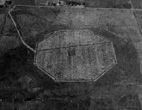
An 11/19/43 aerial view looking north at “Bunker Hill NAS Auxiliary (23008 Outlying Field #3)”
from the 1945 AAF Airfield Directory (courtesy of Scott Murdock).
It depicted the field as a paved octagon, with no buildings visible.
This airfield has the same unusual configuration as the nearby Converse Airport:
the landing area consists of an octagon, 1,800' in diameter.
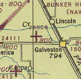
The earliest aeronautical chart depiction which has been located of the Galveston airfield
was on the October 1944 Chicago Sectional Chart (courtesy of Chris Kennedy).
It depicted Outlying Field "23008" as an auxiliary airfield.
The 1945 AAF Airfield Directory (courtesy of Scott Murdock) described “Bunker Hill NAS Auxiliary (23008 Outlying Field #3)”
as a 272 acre irregularly-shaped property within which was a 3,563' x 3,334' sod all-way field
containing an 1,800' blacktop octagonal landing mat.
The field was not said to have any hangars,
to be owned by the U.S. Government, and operated by the Navy.
Outlying Field 23008 was apparently abandoned by the military at some point between 1945-46
(like the vast majority of the WW2 auxiliary airfields),
as it was not depicted at all on the 1946 Chicago Sectional Chart (courtesy of Chris Kennedy).
At some point between 1946-53, it was reopened as a civilian airfield - Galveston Airport.
The earliest depiction of Galveston which has been located is on the 1953 Flight Chart (courtesy of Scott O'Donnell),
which depicted it as a civil airfield with a 1,700' hard surfaced landing area.
The 1962 AOPA Airport Directory described the runway configuration
as being 2 bituminous 1,600' runways: 4/22 & 13/31.
Max Reed (local resident & former Grissom AFB pilot) recalled,
“The Galveston field appeared to have been not so well built or not so well maintained
and was grown up with weeds through the concrete when I visited it in the 1980s & was unusable.”
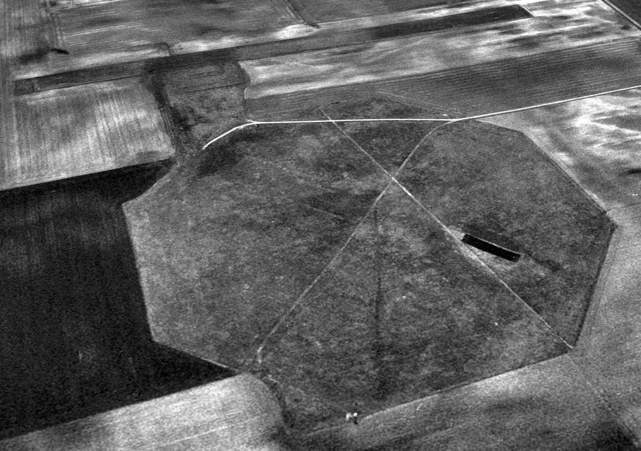
A 1998 aerial view looking northwest at Galveston Airport & the adjacent postwar grass runway.
According to Marty Catron (who lives near Galveston),
"The building at the north east corner of the property is a small building used by the local radio-controlled airplane club.
They have even restored a small bit of the old runway for their own use.
A local farmer keeps the grass and weeds mowed that have grown through the cracked asphalt over the years.
He told me they had planned to return it to tillable soil, but when they probed it, it was about four feet thick!
Another one was built near Greentown, IN,
but had been returned to tillable soil sometime in the 1960's or 1970's."
Galveston Airport is still listed as an active general aviation field,
but flying operations are conducted from an adjacent 2,700' grass runway.
The concrete octagon runway area has apparently been abandoned.
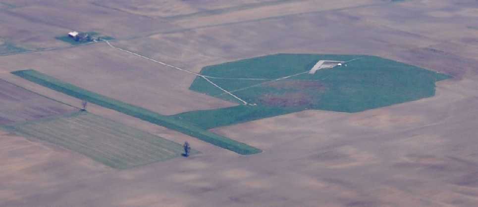
A 2010 aerial view by Bob McKenzie looking northeast at Galveston Airport.
Bob remarked that “Galveston was... overgrown with an adjacent grass runway that appears to be usable.”
Brian Rehwinkel remarked in 2010 of the Converse & Galveston airfields, “It is pretty amazing both of the fields survive 67 years after they were built.
Obviously, the concrete field has remained in better shape, but even the shape of Field # 23008 is still very apparent.
Apparently, the crushed rock base of this field has allowed the shape of the mat to survive well after the top coat of asphalt failed.”

A 2014 aerial view looking northwest at Galveston Airport & the adjacent postwar grass runway.
The facilities of the radio-controlled model aircraft club are visible over the former airfield octagon.
Thanks to Roger Johnson for pointing out this airfield.
____________________________________________________
Since this site was first put on the web in 1999, its popularity has grown tremendously.
That has caused it to often exceed bandwidth limitations
set by the company which I pay to host it on the web.
If the total quantity of material on this site is to continue to grow,
it will require ever-increasing funding to pay its expenses.
Therefore, I request financial contributions from site visitors,
to help defray the increasing costs of the site
and ensure that it continues to be available & to grow.
What would you pay for a good aviation magazine, or a good aviation book?
Please consider a donation of an equivalent amount, at the least.
This site is not supported by commercial advertising –
it is purely supported by donations.
If you enjoy the site, and would like to make a financial contribution,
you
may use a credit card via
![]() ,
using one of 2 methods:
,
using one of 2 methods:
To make a one-time donation of an amount of your choice:
Or you can sign up for a $10 monthly subscription to help support the site on an ongoing basis:
Or if you prefer to contact me directly concerning a contribution (for a mailing address to send a check),
please contact me at: paulandterryfreeman@gmail.com
If you enjoy this web site, please support it with a financial contribution.
please contact me at: paulandterryfreeman@gmail.com
If you enjoy this web site, please support it with a financial contribution.
____________________________________________________
This site covers airfields in all 50 states.