The
Blue Ribbon Mine-"Potato Patch"
Here are a
couple of views of the operations at the 'Potato Patch.'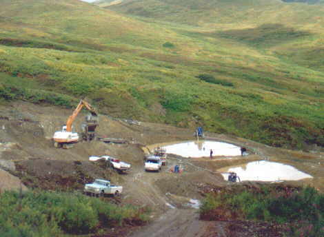 You can see the
settling and recycle ponds in this picture. The process water is
100% recycle, and we have zero discharge from the mine. We even
have a third pond, that is not visible in this photo, to catch
any other runoff that may be muddy. When we are finished, we will
reclaim the land, by respreading the topsoil and planting native
vegetation. We have conducted experiments to determine the most
effective plants for rapid recovery and maximum wildlife habitat
potential, and plan to use that information in our reclamation
efforts. And we reclaim lands that others before us have
disturbed.
You can see the
settling and recycle ponds in this picture. The process water is
100% recycle, and we have zero discharge from the mine. We even
have a third pond, that is not visible in this photo, to catch
any other runoff that may be muddy. When we are finished, we will
reclaim the land, by respreading the topsoil and planting native
vegetation. We have conducted experiments to determine the most
effective plants for rapid recovery and maximum wildlife habitat
potential, and plan to use that information in our reclamation
efforts. And we reclaim lands that others before us have
disturbed.
The orange and
white machine is a Drott 35 D excavator, and it feeds a 40"
diameter by 26' long trommel plant. For scale look at the people
standing on the dike between the ponds. The valley in the upper
right of the photo is Ruby Gulch, of the infamous "Murders
of Ruby Gulch" mystery.
Next,
we see an example of the Tertiary age conglomerate. Look closely,
and you can see the remnants of pebbles. They are now so
weathered and decayed that only the hard quartz pebbles and
boulders remain somewhat intact in a clayey, sometimes a bit
sandy, gold-bearing matrix. In the center right you can see a
rock hammer for scale. (Below the red spot). Pieces of gold in
excess of one ounce have been found in this formation at this
location, along with bright, crystalline and wire gold, and
gold-quartz vein fragments with visible gold. This formation,
called the 'Kenai Formation', rests upon a late Jurassic to early
Cretaceous age argillite and shale, which contains numerous
gold-bearing quartz veins.
The red color
probably represents the old water level, as there is little
pyrite to be found in that section. The blue section below the
red, while essentially the same material, contains unoxidized
pyrite.