Lewis And Clark
On February 28, 1803, President Thomas Jefferson won approval from Congress for an endeavor that would become one of America’s greatest stories of adventure.
Jefferson’s secretary, Meriwether Lewis, and Lewis’ friend William Clark, along with 31 others, would comprise the ranks of what Jefferson called "The Corps of Discovery." *When cost were tallied at the completion of the Lewis and Clark expedition in 1806 --- they exceeded $32,000
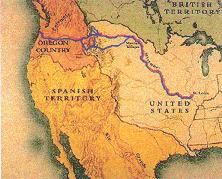
(Outbound Route Shown in Red, Inbound in Blue).
Twenty-five hundred dollars were appropriated to fund the mission to explore the uncharted West. The expedition covered thousands of miles and experienced lands, rivers and peoples that no Americans ever had before.
Although many individuals were associated with the military cadre during its 1803-1804 initial stages of travel from Pittsburgh, Pennsylvania to Fort Mandan, North Dakota, only those 33 members who journeyed from Fort Mandan to Fort Clatsop, Oregon, and returned comprised the Permanent Party. In addition, there was a 34th member – Seaman, Captain Lewis’ “dogg of the Newfoundland breed.”
Two members originally recruited for the Pacific bound party, Privates Moses Reed and John Newman, were dismissed before the explorers reached Fort Mandan. Reed was convicted for desertion, and Newman for “mutinous acts.” Stiff sentences, including “100 lashes on [Newman’s] bear back” were imposed through trials by court martial proceedings. Due to the remote, wilderness places of their crimes, both remained with the party over the Fort Mandan winter, doing hard labor. They were sent downriver aboard the keelboat in the spring of 1806.
Two French-Canadian fur traders, Jean Baptiste LePage and Toussaint Charbonneau, were enlisted at Fort Mandan to replace Newman and Reed. LePage held the rank of private, and Charbonneau, together with his Shoshone Indian wife, Sacagawea, who would be burdened with their infant boy, Jean Baptiste, were recruited as interpreters. The Fort Mandan-to-Fort Clatsop personnel were of white, black, and red racial origins, plus mixtures of the three. The oldest among the men was Charbonneau, who was 47 years old. Sacagawea was a teenager thought to be approximately 17. Jean Baptiste Charbonneau, whom Captain Clark affectionately nicknamed “Pomp” and “Pompy” for his “little dancing boy” antics, was only 55 days old when the explorers departed Fort Mandan on April 7, 1805, bound for the Pacific Ocean.
All the men were hand-picked for their leadership abilities, and their detachment for frontier, hunting, woodcutting, specialized craftmanship, and interpreting skills.
Myths And Purpose
Woolly mammoths, Peruvian llamas, blue-eyed, Welsh-speaking Indians. In 1803, such myths defined the uncharted West. The Lewis and Clark expedition later dispelled such speculations, including the most widely held myth and hope: the existence of a "northwest passage." Rules And Destiny Rules for the officers were strict and specific. They were allowed at least one soldier from the line as a personal servant. Officers were not allowed to swear, express disrespect for their commanding officer or federal or state officials, be intoxicated on duty or absent without leave, or participate in duels. They also were forbidden to take mistresses. Logistics And Speculation
The distance between the Appalachians and the Mississippi, the limited transportation options, and the unanswered questions about the western land were barriers to westward expansion. Also, horses were the fastest mode of transportation, and the few roads or trails that existed were in poor condition. It was impossible to get anything from the Mississippi to the Atlantic seaboard in fewer than six weeks. These barriers helped quell ideas of spreading national interests further west. The half-million Americans (one out of 10) who already lived west of the Appalachian Mountains, however, felt they had found their own "national" interests. Since water routes were viewed as a source of commerce, many people along the Mississippi viewed themselves as the seeds of an independent nation that would tap into the world marketplace, not by going east to the Atlantic seaboard, but by following the Ohio and Mississippi river system down to the Gulf of Mexico. Politics And Conquest
The political climate in 1803 complicated Jefferson’s request. He had asked Congress to authorize a military reconnaissance into unknown lands that already were claimed by the two most powerful nations in the world, France and Britain, with a third, Spain, clinging to a hold in the south and far west.
Such a passage -- a river or series of connected rivers that would cross the western mountains and reach the Pacific Ocean -- would have allowed more direct commerce with the Orient. Thomas Jefferson believed the discovery of the northwest passage would break open the wealth of North America.
Living in America When Jefferson took the Oath of Office as the third President of the United States on March 4, 1801, the nation had 5,308,483 people within its boundaries, which reached from the Atlantic Ocean in the east to the Mississippi River in the west, from the Great Lakes in the north nearly to the Gulf of Mexico in the south (roughly 1,000 miles by 1,000 miles). Only a comparably small area was occupied, however, and two-thirds of the population lived within 50 miles of the Atlantic.
Despite the rules, many officers on the frontier lived flamboyantly, drank heavily, and were promiscuous. Flogging and other harsh punishments were commonly imposed on the enlisted men. Many of them deserted, lured by the chance to run off and lose themselves on the frontier, where they could establish squatters’ rights and escape the discipline. Desertion was a serious problem and was severely punished, because the loss of just a few men in the small garrisons would damage fighting capability in the event of an Indian attack.
Most of the soldiers and others who trekked through the frontier ended up in Tennessee or Kentucky. Some traders and trappers went as far as the Missouri River, but the idea of a mass migration further west was still unrealistic. Navigating Towards Commerce In 1803, Only four roads crossed the Appalachian Mountains. But the United States had the potential to become a powerful nation if it could add the area west of the Mississippi to its territory. At that time, however, people were skeptical that one nation could govern an entire continent.
Jefferson knew the inhabitants of this region posed a risk of secession from the United States. After all, the nation, only 18 years old, was born of rebellion. He was determined to obtain the vital trading port of New Orleans for the United States, in part to prevent the West from breaking away. Other nations also sought to control the West’s destiny but still knew little about the region. Spanish conquistadors had explored the Southwest. French and Spanish fur traders had ventured part of the way up the Missouri River, and the British had visited the Mandan Indians in what is now North Dakota.
Like his fellow scholars, Jefferson had many ideas about the unknown areas westward. He was keenly interested in the region, and his personal library at Monticello had more books about the subject than did any other library in the world. Some of Jefferson’s books described a landmass of erupting volcanoes and mountains of undissolved salt.
Other readings led him to believe that Virginia’s Blue Ridge Mountains might be the continent’s highest. (The Blue Ridge Mountains peak at around 6,500 feet, while the Rocky Mountains in Colorado top out at over 14,400 feet.) Depictions of land and creatures in the west often came from the imaginations of men who had never been there.
Many reports told of western terrain spotted with wondrous creatures: unicorns, gargantuan woolly mastodons, seven-foot-tall beavers, and friendly, slim-waisted buffalo. Maps of the west proved equally fictitious. European geographers, for example, drew maps depicting California as an island. Other maps showed the Rocky Mountains to be narrow and undaunting.
The lack of detail in maps circa 1803 hinted at the enormous task to be faced by the Lewis and Clark expedition. Before the journey, Meriwether Lewis had map collector Albert Gallatin make a special map that showed North America from the Pacific coast to the Mississippi. The map depicted only three points of certainty: the latitude and longitude of the mouth of the Columbia and of St. Louis, and details of what was known of the Missouri River up to the Mandan villages in the Great Bend of the river (today’s Bismarck, North Dakota).
The map also estimated how the Rockies might look and the course of the Columbia, which no one had charted beyond its mouth. But the area that lay between the Mandans west was blank, and the best minds in the world could not fill in that blank until someone had walked the land, taken measurements and described the flora, fauna, rivers, mountains, and people. Observations of the commercial and agricultural possibilities of the regions were equally crucial.
Jefferson: Planning a Nation’s Destiny On January 18, 1803, President Jefferson sent a confidential message to Congress, stating in part, "The river Missouri and the Indians inhabiting it, are not as well known as is rendered desirable by their connection with the Mississippi, and consequently with us. . ." Jefferson went on to propose that an "intelligent officer with ten or twelve chosen men . . . might explore the whole line, even to the Western Ocean."
This proposal culminated Jefferson’s long-standing but quiet plans to send a trailblazing expedition into the great void beyond the Mississippi. And although the president was a scholar of the sciences, his push for such an expedition was as much for political reasons as it was for advancing botany or topography. He viewed commercial growth in the west as the key to a United States stronghold in the region.
Jefferson already had approached Spanish officials administering the region on behalf of France, seeking their approval to pass through the Louisiana Territory for the purposes of exploration. Spanish ambassador Don Carlos Martinez objected, but Jefferson pressed ahead with his request to Congress. Knowing there would be skeptics, especially among his foes in the Federalist party, Jefferson worded his message in a way that minimized military risks and used commercial gains as the bait. He made the temptation cheap, asking only $2,500 to fund the expedition (although actual costs reached $38,722).
On February 28, 1803, Congress approved Jefferson’s request. Jefferson was elated. For nearly two decades he had actively strategized to traverse the west and find the northwest passage to the Pacific. Before becoming president, he had been the force behind at least two other aborted expeditions.
Some historians have speculated that when Jefferson was first elected, he already had begun planning for another expedition because he had hired rural Virginian Captain Meriwether Lewis as his private secretary, instead of qualified applicants who lived nearby. Louisiana Congress’ approval of the journey was a big step forward, yet within months it would be eclipsed by an agreement that not only transformed the purpose of the expedition but the very destiny of the United States.
It began with a bid from Jefferson’s emissaries in Paris to buy the vital trading port of New Orleans. Negotiations had gone nowhere until Napoleon Bonaparte, preparing for another war with England, suddenly announced that the United States could have New Orleans if it would take the entire 820,000-square mile Louisiana Territory for $15 million (about three cents an acre). Bonaparte had his own reasons for the dramatic offer. He held title to Louisiana but had little power to enforce it.
The Americans, he believed, were sure to overrun the area long before he could get an army there, if he ever could. Further, the land sale would empower a young nation that shared one of France’s common rivals: England. Amazed by the offer, Jefferson accepted and rushed the treaty through Congress, in spite of doubts about its constitutionality.
Federalists attacked the purchase not only as a blatant use of executive power, but as a waste of money. Nevertheless, the treaty was signed on April 30, 1803.
In a single stroke, the size of the United States was doubled. The Louisiana Purchase was not publicly announced until July 3, just two days before Meriwether Lewis left Washington, D.C., for Pittsburgh to begin purchasing supplies and hiring men for the expedition.
For Lewis, the purchase changed what would have been a semi-covert mission through foreign territory into a bold survey of American-owned land. Jefferson sent Lewis off with several pages of specific instructions about what information to collect during the journey: