At the end of the Passetto, opposite St.Peter's Square, begins via di Porta Angelica.
In earlier times this road lead to Porta Angelica, the second gate of Pius IV's wall;
the name "Angelica" was chosen by the pope, whose name was Angelo Medici.
 |
Before 1930, the Italian and Vatican territories were not actually separated; following the
concordat known as "the Conciliation", a modern wall was built on the left side of the road, as a
real boundary between the two countries.
Here is Porta Sant'Anna,
[map ref. b], the only access to the
small state for non-Vatican citizens (a permit or visa is required); a big round tower built by pope
Nicholas V in the 15th century can be noticed among the buldings at the end of the
road behind the gate [map ref. c]: you can
easily see its side, but unless you hold a permit you should go no further than the Vatican's
threshold, to avoid a "close encounter" with the Swiss soldiers on permanent guard,
rather strict with anybody.
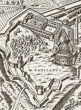
the walls around the Vatican (map dated 1590, pointing eastwards):
in the top right corner is Porta Angelica, and Porta Pertusa is on the
opposite side; the early wall by Leo IV and the round towers by
Nicholas V are clearly visible within the new boundary
|
At the end of via di Porta Angelica, as soon as the tall palm trees of piazza del Risorgimento come
into sight, notice how the modern wall quite abruptly turns again into the typical brick
structure with the white kerbstone [map ref. d]:
this is where Pius IV's boundary reached the Vatican, at the end of Borgo Nuovo.

the original Porta Angelica,
in an 18th century engraving |
Right here stood Porta Angelica, through which pilgrims heading to St.Peter's
tomb entered the city. Also the long and straight road which ran towards the north from this gate
was called via Angelica; Pius IV had it opened as a short cut for travellers coming to Rome along the
Cassian way (one of Rome's most important northern approaches): nowadays, the modern street names
have changed, but the road still runs straight for about one mile and reaches the Tiber, where
it follows the river bank for another ½ mile, finally meeting with the old via Cassia.
The papal crest on the corner, though, belongs to Pius XI, who was pope by the time the modern
Vatican boundaries were agreed.
As explained in the previous part of the tour, the gate and most part of the wall
(from this corner up to the castle) were taken down in the late 19th century. |
Only very few remains have survived [map ref. e]:
just round the corner, fragments of the original Angelica Gate (two angels, a papal crest and
a Latin inscription reading "HE SENT YOU HIS ANGELS TO PROTECT YOU IN EACH OF
YOUR STREETS") have been walled here, facing the square. On the opposite side of the
road, below the street level, a short part of the base of the wall can be seen under a glass
protection: this also shows how much the modern street level has raised since the making of
the wall. |

the remaining fragments of the gate |
The short road at the bottom of the square is called via dei Bastioni di Michelangelo. Here
the wall by Pius IV merges into the older structure, built a few years
earlier by pope Paul III. Notice the big difference in hight between the two: the
first wall barely reaches the kerbstone of the older one.
The building high above the walls is the Belvedere Palace.

the corner where Pius VI's wall (left)
merges into Paul III's bastion (right) |

the bastion of Paul III,
drawn by Michelangelo |
By the first crossing, the wall sharply turns into a strong bastion
[map ref. f];
a large crest of Paul III's family (the Farnese), featuring six fleur-de-lys,
hangs above the corner. This bastion was drawn by Michelangelo. |
The wall now runs by viale Vaticano, a long road climbing towards the western side
of the Vatican.
We soon pass by the entrance of the Vatican Museums.

the Vatican Museums' entrance
A modern neighborhood has recently developed by the walls, where the hill once protected
the citadel.
Due to the road's several sharp turns, it is safer to walk on the side of the road opposite
the wall, always being careful of the fast traffic. |
The road gradually grows steep, and as soon as it comes to a left turn, the environment
somewhat changes: viale Vaticano becomes more narrow, winding around the tall bastions up
to the top of the hill.

a view along the western side of the walls
|
It might seem strange that this long stretch of boundary had no gates at all;
but beyond Leo's City the land was wild, and no roads crossed this area:
a gate here would have made no sense, merely weakening the structure.
However, a few small service passages were opened here: they enabled the masons to check the wall
and to restore it, when needed; all of them have been walled up, but they can be spotted out
by the different brick texture.

the crest of pope
Urban VIII (Barberini) |
Along this side, you will also notice several crests belonging to
the popes who had the wall restored. In particular, you will see a few ones featuring three
bees, the Barberini family arms, referring to Urban VIII.
At the top of the hill, we finally reach the westernmost bastion, so sharp that the road
almost makes a U-turn: from this corner it is possible to take a view of both the western and
southern sides of the wall. |

the sharp bastion on the western end |


