
Abandoned & Little-Known Airfields:
Northern Arkansas
© 2002, © 2016 by Paul Freeman. Revised 9/22/16.
This site covers airfields in all 50 states: Click here for the site's main menu.
____________________________________________________
Please consider a financial contribution to support the continued growth & operation of this site.
Biggers Aux AAF #2 / Reyno Airport (revised 9/2216) - (Original) Conway Municipal Airport / Dennis F. Cantrell Field (added 8/31/16)
Heber Springs Airport (1st location) (added 3/11/15) - Heber Springs Airport (2nd location) (added 3/11/15)
Heber Springs Airport (3rd location) (added 3/11/15) - Rogers Field (added 4/24/16) - Walcott Aux AAF #3 (revised 3/15/14)
____________________________________________________
(Original) Conway Municipal Airport / Dennis F. Cantrell Field (CWS), Comway, AR
35.083, -92.425 (Northwest of Little Rock, AR)

The original Conway Airport, as depicted on the 1956 USGS topo map.
The original airport for the town of Conway was located on the southeast side of the town.
The date of construction of Conway Municipal Airport has not been determined.
The oldest depiction which has been located of Conway Municipal Airport was on the 1956 USGS topo map.

The 1961 USGS topo map depicted Conway Municipal Airport as having a single paved northeast/southwest runway,
with a paved taxiway leading to a ramp & 3 small buildings on the northwest side.

Conway Municipal Airport evidently gained a crosswind paved north/south runway at some point between 1961-81,
as that is how it was depicted on the 1981 USGS topo map.

The earliest photo which has been located of Conway Municipal Airport was a 1990 USGS aerial view looking southeast.
A dozen light single-engine aircraft were visible parked among the hangars on the northwest side.
It was still depicted as Conway Municipal Airport on the 1994 USGS topo map.

A circa 2010 aerial view looking southeast at Conway Municipal Airport.
According to its FAA Airport/Facility Directory data, as of 2010 Conway Municipal Airport conducted an average of 48 takeoffs or landings per day,
and had a total of 41 based aircraft.
It comprised 198 acres, within which were 2 asphalt runways: 4,875' Runway 8/26 & 3,278' Runway 18/36.

A circa 2013 photo looking south at several light single-engine aircraft parked under a shade hangar on the northwest side of Conway Municipal Airport.

The last photo which has been located showing Conway Municipal Airport still open was a 2014 aerial view looking southeast.
At some point before 2014, the airport was evidently renamed Dennis F. Cantrell Field.
Cantrell Field was replaced by the new Conway Airport at Cantrell Field (several miles west) in September 2014,
at which point it was evidently closed.
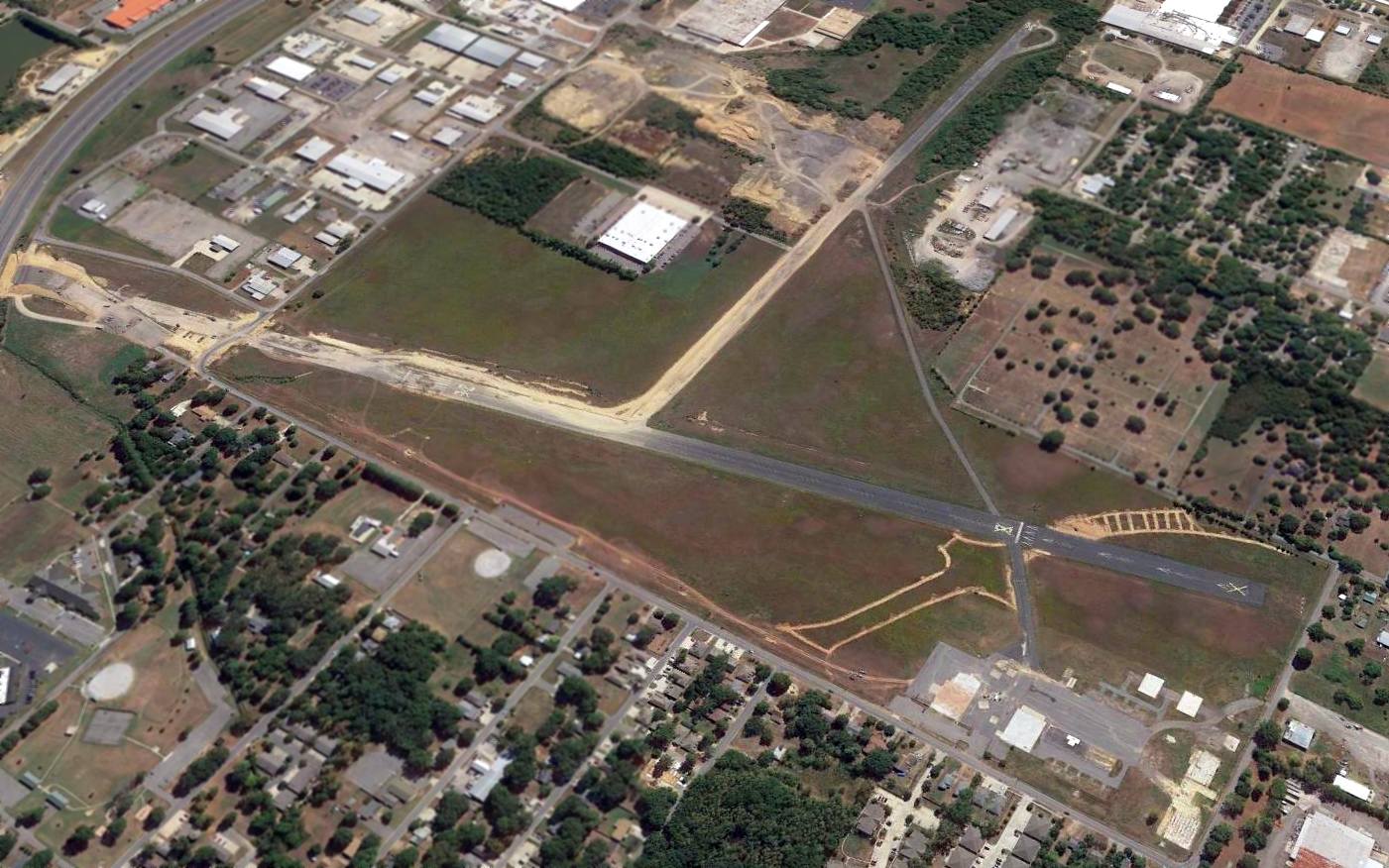
A 2015 aerial view looking southeast showed that Cantrell Field's 2 runways had already been partially removed, as had all of its hangars & buildings.
The property of Dennis F. Cantrell Field was sold for around $6 million,
to be redeveloped into shopping destination & lifestyle center named "Central Landing", scheduled to open in September 2016.
The site of Dennis F. Cantrell Field is located south of the intersection of 5th Avenue & 6th Street.
Thanks to John Phillips for pointing out this airfield.
____________________________________________________
Heber Springs Airport (1st location), Heber Springs, AR
35.49, -92.11 (Northwest of Memphis, TN)

The locations of the 4 different Heber Springs Airports (annotated by Charles Staurt over a 2014 USGS map).
This is an unusual tale of a small-town general aviation airport which had 4 different locations within 4 decades.
According to Charles Stuart, “The first airfield was built by the Casey brothers in 1932 three miles west of Heber Springs.”

A circa 1930s photo of Pauline Anderson & friends ready for ride in an unidentified biplane at Heber Springs (courtesy of Charles Staurt).
According to an article in the 10/6/32 Heber Springs Times-Headlight entitled “Heber to Celebrate on Oct. 14-15” (courtesy of Charles Stuart),
“A squadron of 25 or more airplanes will visit the city on Friday on a statewide tour.
Biggest event in years. Merchants staging 2 trade days, with aerial squadron on Friday & races & other events on Saturday.
It is thought that they will do stunts & fly in various formations over the field.
This squadron is comprised of little airplanes & big airplanes, passenger planes & fleet planes, tri-motored planes & small midget planes.
Planes of all descriptions & from every airport in the state.
These planes will gather in Little Rock Friday morning & make a tour of the entire state. Their first stop will be Heber Springs.
Here they will rest for a time & give demonstrations & such before flying on to the next airport.
The only reason that Heber Springs is privileged to get this squadron is that it had an airport that is sufficiently large enough to care for the planes.
The local Casey boys will have charge of the visitors while here.
Other residents will also probably be on the welcoming committee.
Following the visit of the airplanes, the crowd will be invited to Heber Springs where the celebration will continue.”
The article continued, “Heber Springs Airport, constructed recently by the Casey brothers, has been put in readiness for reception of the planes.
The public is asked to be at the field where they can greet the planes & pilots.
This also affords a wonderful opportunity to inspect the field. Its location is 3 miles from the city.
This event in itself is one worth coming hundreds of miles to view.
Heber Springs is the only landing place in this section of the state with an airport sufficiently large to care for the group.
Everyone in the county is urged to be at the airport. There will be no charges. A good road leads up to the airport.”
According to an article in the 10/20/32 Heber Springs Times-Headlight (courtesy of Charles Stuart),
“The 2 big days brought thousands to the airplane tour visit & the horse show proved interesting amusement to all who visited Heber Springs last week.
As scheduled, Friday morning 17 airplanes landed at the Heber Springs airport recently constructed & owned by the Casey boys.
These planes were of all descriptions from 5-passenger cabin planes to small open planes.
The Rotary Club had arranged a fine program for the visitors & the wives of the members had arranged a fine lunch.
Upon arrival of the visitors & the planes they were met by the queen & maids so named especially for this occasion.
Irma Dean Hofstead as queen & Mildred Blevins & Clara May Morton.
Previous to their coming, an essay contest had been held at the high school on 'What the Air Tour Means to Arkansas'.
The winners in this, Betty Vining, Mary Frances Raywinkle, and Richard Starr,
were presented to the air tour guests & were taken for a ride in one of the planes.
Then the queen & maids were taken for a ride. And then the Mayor & wife & Mrs. O.B. Robbins were taken aloft.”
The article continued, “The planes left here on schedule. Not less than 2,500 enthusiastic people of the city and country were there to greet the planes when they arrived.
The boy scouts had charge of keeping the crowd back & parking the more than 350 cars that drove up.
This they did in fine shape. The school band amused the guests & visitors with a fine program that lasted until the planes started arriving.
The Little Rock papers lauded very highly the reception given the tour in Heber Springs & mentioned it above any of the other stopping places.
They were awfully high in their praise for the work done by the Casey boys in bringing the fine field to this town.”
Gerald Varner, who was born in 1926, near where the Casey’s would build their airport recalled:
“We attended an air show at Casey’s Airport (now Eden Isle), when I was about 6 years old.
We traveled to it in our wagon, which was pulled by our team of mules.
Many other families also came in wagons. We saw acrobatics, wing walking, and a parachute jump.
At that time, traveling to an air show in a wagon did not seem odd.”
According to an article in the 5/17/34 Heber Springs Times-Headlight entitled “Tragic Death of Paul G. Casey” (courtesy of Charles Stuart),
“Last Sunday evening, Paul Casey met a tragic death in a collapse of his airplane at the Heber Springs airport.
He was just starting on his 5th flight for the afternoon.
He had taken up a passenger on former trips but fortunately on the 5th attempt, he was alone.
The immediate cause of the accident was too close proximity to the tree tops.
He had not sufficiently cleared them. Both wings were torn off & the motor was torn out. It was a complete wreck.
It was inevitable that the pilot was instantly killed. Experts have passed upon the accident. They have pronounced the plane in perfect condition.
Paul had just received his license to fly only the Wednesday before.
He was happy & enthused with his new ability & privilege to make solo flights.
If he could have been content with thrills enough for one day, he would have been with us still.”
According to Charles Stuart, the first Heber Springs Airport ceased operation upon Paul Casey's 1934 accident.

A 1938 aerial view, annotated by Charles Stuart with a red “X” to indicate the site of the first Heber Springs Airport.
The area outside the black line would be flooded by Greers Ferry Lake in 1963.
According to Charles Stuart, “This site became the Red Apple Inn Golf Course & Resort after Greers Ferry Lake was built in 1963.”

A 2012 aerial photo showed the golf course covering the site of the 1st location of Heber Springs Airport, with no trace recognizable of the former little airport.
The site of the 1st location of Heber Springs Airport is located southwest of the intersection of Club Road & Orchard Lane.
Thanks to Charles Stuart for pointing out this airfield.
____________________________________________________
Heber Springs Airport (2nd location), Heber Springs, AR
35.515, -92.028 (Northwest of Memphis, TN)

The locations of the 4 different Heber Springs Airports (annotated by Charles Staurt over a 2014 USGS map).
This is the 2nd of 4 eventual locations of Heber Springs Airport.
According to Charles Stuart, in 1939 Raymond Black opened this airfield one mile north of Heber Springs, on the east side of Heber Springs Road,
replacing the original field to the west which had closed in 1934.
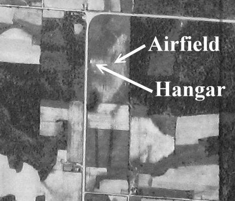
A 1942 aerial view, annotated by Charles Stuart to show the north/south grass runway & hangar of the 2nd location of Heber Springs Airport,
on the east side of Heber Springs Road.
According to Charles Stuart, the Heber Springs Airport on the east side of Heber Springs Road operated until 1947,
when it was relocated across the road, to the west side of Heber Springs Road.

A 1954 aerial view (courtesy of Charles Stuart) showed the hangar remained at the 2nd location of the Heber Springs Airport.

A 1961 aerial view (courtesy of Charles Stuart) showed hangar on the east side of Heber Springs Road (the 2nd location of Heber Springs Airport)
had been removed at some point between 1954-61.

A 2012 aerial photo of the site of the 2nd location of Heber Springs Airport, with no trace recognizable of the former little airport.
The site of the 2nd location of Heber Springs Airport is located east of the intersection of Heber Springs Road & Tulaka Boulevard.
Thanks to Charles Stuart for pointing out this airfield.
____________________________________________________
Heber Springs Airport (3rd location), Heber Springs, AR
35.514, -92.03 (Northwest of Memphis, TN)

The locations of the 4 different Heber Springs Airports (annotated by Charles Staurt over a 2014 USGS map).
This is the 3rd of 4 eventual locations of Heber Springs Airport.
According to Charles Stuart, in 1947 Raymond Black bought land across Heber Springs Road
and relocated Heber Springs Airport to the west side of the road.

A 1954 aerial view, annotated by Charles Stuart to show the 2 grass runways & hangar of the 3rd location of the Heber Springs Airport.

A 1955 photo of a hangar (with 1 single-engine aircraft inside) & gas pump of the 3rd location of the Heber Springs Airport (courtesy of the Cleburne County Historical Society, via Charles Stuart).
According to Charles Stuart, in 1959 the City of Heber Springs partnered with Raymond Black
and paved the runway & made other improvements to the 3rd location of Heber Springs Airport.

A 1959 photo of the Heber Springs Mayor & Hospitality Committee at the dedication of the 3rd location of the Heber Springs Airport (courtesy of the Cleburne County Historical Society, via Charles Stuart).

A 1959 aerial view looking west at the dedication of the 3rd location of the Heber Springs Airport (courtesy of Raymong Black of the Cleburne County Historical Society, via Charles Stuart),
showing 14 single-engine & twin-engine aircraft next to the hangar on the north side of the field.

A 1959 aerial view looking south at the dedication of the 3rd location of the Heber Springs Airport (courtesy of Raymong Black of the Cleburne County Historical Society, via Charles Stuart),
showing 14 single-engine & twin-engine aircraft next to the hangar on the north side of the field.

A 1961 aerial view of the 3rd location of Heber Springs Airport (courtesy of Charles Stuart) showed the field after the north/south runway had been paved by the City.
According to Charles Stuart, the “runway was angled 4 degrees southwest at the request of a homeowner,
whose 2-story house sat on a slight rise” to the south of the field.
According to Charles Stuart, in 1968 Heber Springs acquired yet another location further east for their airport,
its 4th location in 4 decades, and built a new airport & abandoned the 3rd location.
The old area was developed into retail businesses as Heber Springs grew after Greers Ferry Lake was built.

A 2012 aerial photo of the site of the 3rd location of Heber Springs Airport, with no trace recognizable of the former little airport.
The site of the 3rd location of Heber Springs Airport is located west of the intersection of Heber Springs Road & Tulaka Boulevard.
Thanks to Charles Stuart for pointing out this airfield.
____________________________________________________
Biggers Auxiliary Army Airfield #2 / Reyno Airport, Biggers, AR
36.33, -90.764 (Northwest of Memphis, TN)

The Biggers “aux field", as depicted on a 1943 a map issued to Walnut Ridge Army Flying School students
(courtesy of Harold Johnson of the Walnut Ridge Army Flying School Museum).
This airfield was originally established as a military satellite field
used to support flight training operations at nearby Walnut Ridge AAF.
The Biggers airfield was apparently built at some point between 1939-41,
as it was not yet listed among active airfields in the 1938 Civil Aeronautics Administration Bulletin #2.
The earliest reference to Biggers which has been located
was in the Airport Directory Company's 1941 Airport Directory (according to David Brooks).
It was listed as an auxiliary airfield, associated with Walnut Ridge.
However, Biggers was not depicted at all (perhaps overlooked as a relatively minor field)
on the October 1941 Tulsa Sectional Chart (courtesy of Chris Kennedy).
The earliest depiction of Biggers which has been located
was on a 1943 map issued to Walnut Ridge Army Flying School students
(courtesy of Harold Johnson of the Walnut Ridge Army Flying School Museum).

The only photo which has been located showing the Biggers airfield during its operational days
was a 4/14/43 aerial view looking east from the 1945 AAF Airfield Directory (courtesy of Scott Murdock).
It depicted Biggers as a rectangular field within which were 2 runways.

The earliest official chart depiction which has been located of the Biggers field
was on the March 1944 Tulsa Sectional Chart (courtesy of Chris Kennedy).
It depicted "Biggers #2" as an auxiliary airfield.
The April 1944 US Army/Navy Directory of Airfields (courtesy of Ken Mercer)
described "Biggers Aux #2, Army" as having a 4,500' hard-surfaced runway,
and the remarks said, "Aux to Walnut Ridge AAF."
Walnut Ridge was taken over later in WW2 by the Marine Corps & renamed MCAS Walnut Ridge.
Biggers was also reused by the Marine Corps (along with several other Walnut Grove auxiliary fields).

"Biggers (Aux) (Navy)", as depicted on the 1945 Tulsa Sectional Chart (courtesy of Chris Kennedy).
The 1945 AAF Airfield Directory (courtesy of Scott Murdock)
described “Walnut Ridge Marine Corps Air Facility Auxiliary (Biggers Field)” as being inactive.
The field was said to consist of a 640 acre square field
within which were 2 bituminous 4,500' runways, oriented north/south & northeast/southwest.
The field was not said to have any runways,
to be owned by the U.S. Government, and to operated by the Marine Corps.
Biggers may have been reused as a civilian airport by 1946,
as "Biggers" was depicted as an auxiliary airfield, but without any indication of being a military field,
on the September 1946 Tulsa Sectional Chart (courtesy of Chris Kennedy).

At some point between 1946-54, the field was renamed "Reyno",
as that is how it was labeled on the 1954 Tulsa Sectional Chart (according to Chris Kennedy).
The length of usable runway had apparently been cut almost in half, though,
as Reyno was depicted as having only a 2,300' hard surface runway.
Reyno Airport was evidently closed (for reasons unknown) at some point within the next year,
as no airfield at the site was depicted on the December 1955 Tulsa Sectional Chart (according to Chris Kennedy)
or subsequent Sectional Charts.

A 3/3/63 aerial photo of the site of Reyno Airport showed a 2,200' segment of the pavement of the north/south runway still remained intact,
along with a small portion of the former northeast/southwest runway.
Traces of the remainder of the northeast/southwest runway remained recognizable.
The 1968 USGS topo map only depicted a 2,200' segment of the former north/south runway (along with the slightest hints of a former northeast/southwest runway),
labeled as "Old Reyno Airport".

A 2,200' segment of the former north/south runway (along with the slightest hints of a former northeast/southwest runway)
were still depicted on the 1980 USGS topo map, labeled "Old Reyno Airport".
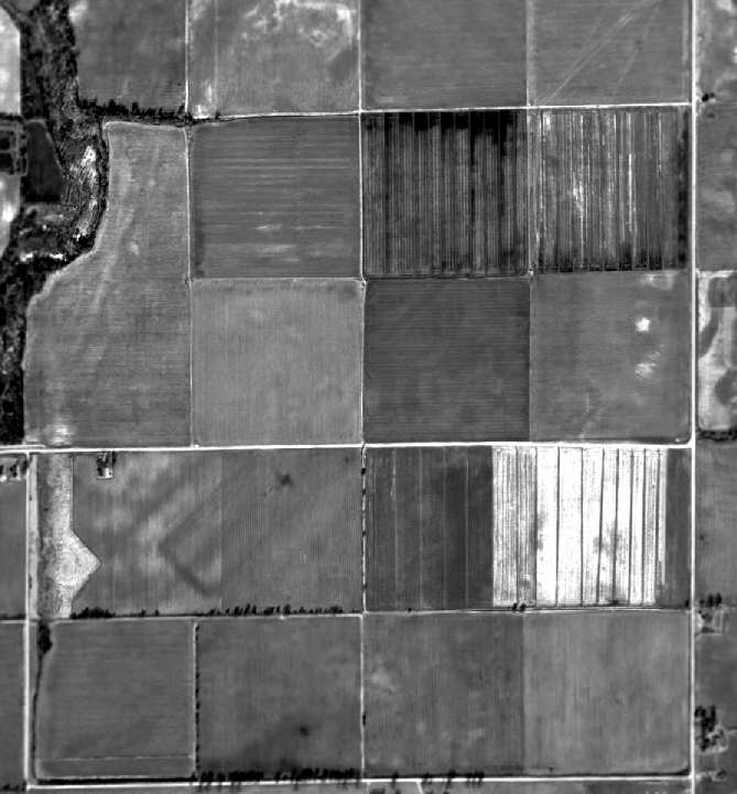
As can be seen in a 1994 USGS aerial photo, the Reyno Airport property had reverted to farming,
but the faint trace of the outline of the northeast/southwest runway was still perceptible,
while there was no trace of the north/south runway.
What appears to be the shadow of an aircraft is visible just southwest of the center of the photo -
maybe the aircraft which took the photo?

A 2013 aerial view showed no trace remaining of Reyno Airport.
The site of Biggers Aux AAF is located northwest of the intersection of Lawnbird Road & Duck Levee Road.
Thanks to Joe Benson for pointing out this airfield.
____________________________________________________
Walcott Auxiliary Army Airfield #3, Walcott, AR
36.04, -90.7 (Northwest of Memphis, TN)

The Walcott “aux field", as depicted on a 1943 a map issued to Walnut Ridge Army Flying School students
(courtesy of Harold Johnson of the Walnut Ridge Army Flying School Museum).
This field was apparently built during WW2 as one of the satellite airfields used by trainees from Walnut Ridge AAF,
which conducted training as part of the 50,000 Pilot Training Program.
The Walcott airfield was apparently built at some point between 1941-43,
as it was not yet depicted on the October 1941 Tulsa Sectional Chart (courtesy of Chris Kennedy).
The earliest depiction of Walcott which has been located
was on a 1943 a map issued to Walnut Ridge Army Flying School students
(courtesy of Harold Johnson of the Walnut Ridge Army Flying School Museum).

The earliest official chart depiction which has been located of the Biggers field
was on the March 1944 Tulsa Sectional Chart (courtesy of Chris Kennedy).
It depicted "Walcott #3" as an auxiliary airfield.
The April 1944 US Army/Navy Directory of Airfields (courtesy of Ken Mercer)
described "Walcott Aux #3, Army" as having a 4,500' hard-surfaced runway,
and the remarks said "Aux to Walnut Ridge AAF."
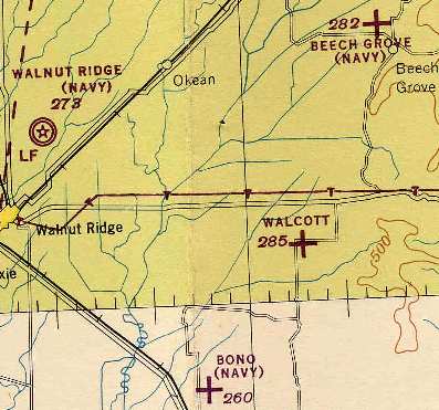
Walnut Ridge AAF was taken over later in WW2 by the Marine Corps & renamed MCAS Walnut Ridge.
It is not known if Walcott was also reused by the Marine Corps,
as it was simply labeled "Walcott" on the 1945 Tulsa Sectional Chart (courtesy of Chris Kennedy),
whereas several other Walnut Ridge Auxiliary Fields had the subtitle "(Navy)" on the chart.
Walcott may have been reused as a civilian airport by 1946,
as " Walcott " was depicted as an auxiliary airfield, but without any indication of being a military field,
on the September 1946 Tulsa Sectional Chart (courtesy of Chris Kennedy).

The earliest photo which has been located of the Walcot airfield was a 4/2/48 USGS aerial view.
It depicted the field as having 2 paved runways with parallel taxiways.

"Walcot AF" was still depicted on the 1954 Tulsa Sectional Chart (according to Chris Kennedy),
which seems to indicate that the field had been reactivated by the Air Force.
The field was depicted as having a 4,500' hard surface runway.
"Walcot AF" was still depicted on the December 1955 Tulsa Sectional Chart (according to Chris Kennedy).

The Walcot airfield was apparently abandoned at some point between 1955-58,
as it was labeled “Emergency Landing Field (Abandoned)" on the 1958 USGS topo map.
It depicted the field as having 2 paved runways with parallel taxiways.
The Walcot airfield was apparently abandoned at some point between 1955-64,
as it was no longer depicted at all on the April 1964 Tulsa Sectional Chart (according to Chris Kennedy).
No airfield at Walcott was depicted on the 1976 USGS topo map.
However, a single northwest/southeast runway was depicted on the 1980 & 1992 USGS topo maps.
In a 1994 USGS aerial photo, the "ghosted" outline of the 2 runways was still recognizable.

A 4/4/13 aerial photo showed the "ghosted" outline of the 2 runways.
The property is sharply delineated by a road forming a perfect square,
which makes the site quite distinctive among the surrounding farmland.
Blake Brown visited the site of Walcott Aux AAF on 7/28/13:
“You can tell at one time it was an airbase. Arkansas State University owns it,
and they lease the land that is farmable to Terry Smith, and he is farming corn on it, but you can tell that it was once a airbase.
There is still remains of the runways there & the farmer told me that in spots that it is in pretty good shape if a guy removed all the moss & grass.
They also use it to fly Ag-cats out of to spray local fields.”
The site of Walcott Aux AAF is located west of the intersection of Route 280 & Greene Road 318.
____________________________________________________
36.36, -94.19 (Northwest of Little Rock, AR)
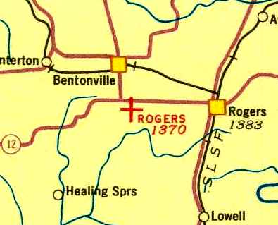
Rogers Field, as depicted on a 1934 Airway Chart.
Photo of the airfield while open has not been located.
The original airport for the town of Bentonville was located on the southeast side of the town.
The date of Rogers Field's construction has not been determined.
It was not depicted on the 1928 USGS topo map, nor listed in The Airport Directory Company's 1933 Airport Directory (according to Chris Kennedy).
The earliest depiction of Rogers Field which has been located was on the 1934 Airway Chart.
It described Rogers as an auxiliary airfield.
The 1934 Department of Commerce Airport Directory (according to Chris Kennedy) described Rogers Field as an auxiliary airfield,
consisting of a rectangular clay & loam field, measuring 1,320' north/south by 900' east/west.
Rogers Field was evidently closed at some point between 1934-41,
as a July 1941 aeronautical chart (according to Chris Kennedy) no longer depicted the field.
It had been replaced by a larger Bentonville Airport, southwest of the town.
Rogers Field was no longer depicted on the 1944 USGS topo map,
and a 3/25/68 USGS aerial view did not show any recognizable trace of an airfield.
On recent street maps, the location of the original Rogers Airport was covered by residential streets,
with the names Convair Street, Douglas Street, Boeing Street, and Lockheed Street.

In the 2001 USGS aerial photo, not a trace of Rogers Airport was still recognizable at the site.
The large warehouse complex bordering the west side of the site is presumably part of the Wal-Mart facilities in Bentonville.

A 2005 photo by Jeff Ferguson of the sign at the entrance to the Sky View neighborhood,
on the site of the original Rogers Airport.

A 2016 aerial view showed no trace remaining of Rogers Airport.
Thanks to Jeff Ferguson for pointing out this airfield.
____________________________________________________
Since this site was first put on the web in 1999, its popularity has grown tremendously.
That has caused it to often exceed bandwidth limitations
set by the company which I pay to host it on the web.
If the total quantity of material on this site is to continue to grow,
it will require ever-increasing funding to pay its expenses.
Therefore, I request financial contributions from site visitors,
to help defray the increasing costs of the site
and ensure that it continues to be available & to grow.
What would you pay for a good aviation magazine, or a good aviation book?
Please consider a donation of an equivalent amount, at the least.
This site is not supported by commercial advertising –
it is purely supported by donations.
If you enjoy the site, and would like to make a financial contribution,
you
may use a credit card via
![]() ,
using one of 2 methods:
,
using one of 2 methods:
To make a one-time donation of an amount of your choice:
Or you can sign up for a $10 monthly subscription to help support the site on an ongoing basis:
Or if you prefer to contact me directly concerning a contribution (for a mailing address to send a check),
please contact me at: paulandterryfreeman@gmail.com
If you enjoy this web site, please support it with a financial contribution.
This site covers airfields in all 50 states.