Abandoned & Little-Known Airfields:
Arizona - Southeastern Tucson area
© 2002, © 2016 by Paul Freeman. Revised 9/21/16.
This site covers airfields in all 50 states: Click here for the site's main menu.
____________________________________________________
Please consider a financial contribution to support the continued growth & operation of this site.
Allied Airfield (revised 11/8/14) - Macauley Field / Fishburn Field / Tucson Municipal Flying Field / Mayse Field (revised 4/26/13)
Sahuarita AF Flight Strip (revised 9/21/16) - Tucson Airport / Downtown Tucson (revised 8/28/16) - Wagon Wheel Airport (revised 4/29/12)
____________________________________________________
Wagon Wheel Airport, Tucson, AZ
32.22, -110.79 (North of Davis-Monthan AFB, AZ)
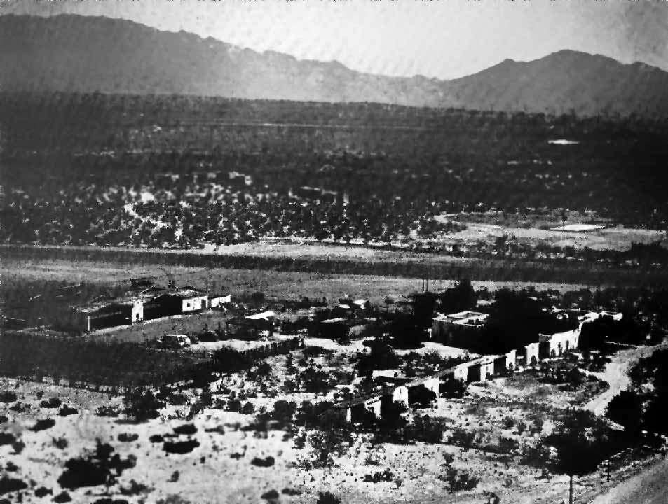
An undated aerial view of Wagon Wheel Airport from a 1947 magazine article (courtesy of Jerry Sorrell, enhanced by Bill Grasha).
This short-lived airfield was evidently established at some point between 1945-47
(like hundreds of other general aviation airports across the US in the post-WW2 aviation boom),
as it was not yet listed among active airfields in the 1945 AAF Airfield Directory (courtesy of Scott Murdock)
nor depicted on the 1945 Phoenix Sectional Chart (courtesy of John Voss).
The earliest depiction of which has been located of Wagon Wheel Airport was a series of pictures from a 1947 magazine article (courtesy of Jerry Sorrell).
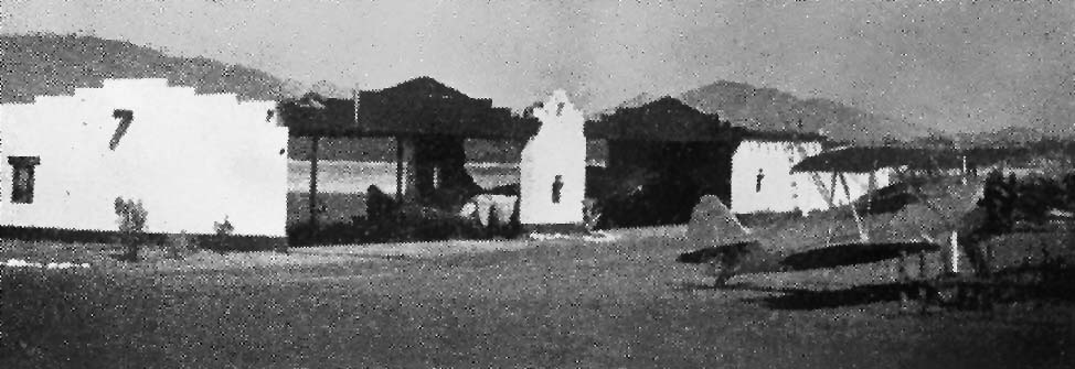
An undated photo of a biplane in front of several hangars at Wagon Wheel Airport from a 1947 magazine article (courtesy of Jerry Sorrell, enhanced by Bill Grasha).
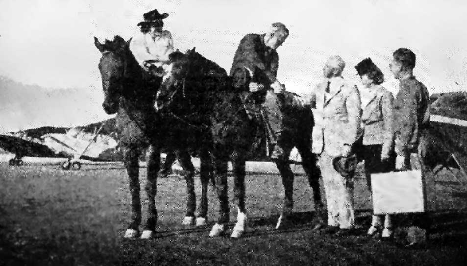
An undated photo of fly-in guests being greeted from horseback at Wagon Wheel Airport, from a 1947 magazine article (courtesy of Jerry Sorrell, enhanced by Bill Grasha).
Wagonwheel Airport was the subject of a 1948 court case, in which neighbors complained of airplane noise.
That was presumably the reason for the airport's closure.
Wagonwheel Airport was evidently closed by 1948, as it was no longer depicted on the 1948 USGS topo map
nor on the 1949 Phoenix Sectional Chart (courtesy of Chris Kennedy)..
____________________________________________________
32.15, -110.85 (Southeast of Davis-Monthan AFB, AZ)
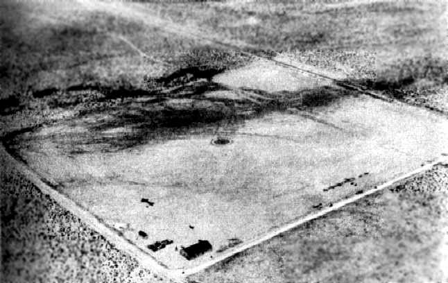
A 1972 aerial view depicted the Allied airfield as having a single dirt east/west runway.
Davis-Monthan AFB is the home of the huge “boneyard”,
the final resting place of thousands of former military (and some civilian) aircraft.
Adjacent to the southeast side of the Air Force property are a number of aviation scrap yards
which purchase retired airframes from Davis-Monthan
to later retrieve parts & sometimes entire planes for the military, museums, and restoration shops.
According to Jonathan Westerling, one of these scrapyards is Allied Aircraft Sales,
located immediately beyond the southeast end of Davis-Monthan's main runway.
The company is listed in many online directories as the final resting place for many many aircraft serial numbers.
No airfield at the Allied property was yet depicted on the 1957 topo map, a 1958 aerial view,
or Phoenix Sectional Charts from 1958 & 1968 (according to Chris Kennedy).
At some point in the 1960s, a 3,600' dirt runway, oriented east/west, began to be used for takeoffs from the Allied property.
Larry Kotz of K-Tech Aviation recalled Allied Airstrip as being what is now Drexel Road.
“It was a dirt road on Allied’s property.
Planes flew out of there a long time ago - like the 1960s & 1970s.”
JR Kern remembered the takeoffs from Allied field, though.
His father Jack worked for Allied starting in the mid-1960s.
When asked why Allied didn’t just use the runway at adjacent Davis-Monthan,
JR replied “We landed [planes] there, but to takeoff, [the Air Force] required hefty insurance.
So we usually took off from our own runway whenever we could.”
The earliest depiction which has been located of the Allied airfield was a 1972 aerial view.
It depicted Allied as having a single dirt east/west runway,
with an amazing assortment of retired aircraft on either side of the strip.
Unfortunately the only crash that occurred at Allied
was enough to convince the company to diminish its use as an airfield.
On January 2, 1975, Jack Kern tried to takeoff in a Douglas DC-4B.
According to his son J.R., it failed to clear the power lines on the other side of the railroad tracks & crashed.
The plane was a total loss.
The FAA accident report from this occurrence described Allied Airfield as being a 3,060' soft dirt strip.
Gordon Cheeseman provided further details of the DC-4 crash: “It was the elevators locks that were left on.
The story begins the day before... January 1, 1975, we had just replaced the carburetor on the #3 engine
and were going to do a test run of the engines.
The aircraft was purchased by Mid-Air out of Barstow CA,
a spray operation using large aircraft to do spruce bud worm contracts out of eastern Canada.
It would be the first company to use GPS mapping on-board DC-7 aircraft.
The DC-4 was for parts, mainly the engines, too good of a deal to pass up.
It was a shoe-string budget & everyone was hired cheap.
The plane if everything was OK was to be flown to the main airport in Arizona to refuel & fly back home to California.”
Gordon continued, “The runs started late in the afternoon & right away things were going wrong, no brakes, shut down.
Bleed the brakes on the left, seemed to fix the problem but not for the right. Another shut down.
We pinched the #4 lines to stop the hydraulic leaks on the right brakes.
No worries plenty of brakes for the long runways ahead.
Too late in the day to continue, first thing tomorrow then.
It was a clear day, I remember it like it was yesterday.
My brother & I were fighting over who would get to go.
I won, mainly because I didn't have a drivers license & someone had to drive the pilot's Camaro over to the main airport.
I was looking forward to playing with the bomber scope that was still on board, that was what the fight was about.”
Gordon continued, “The pilots were using a check list from the day before.
They started the engines & scrolled down to where they thought they left off.
Talk in the cockpit was about reaching V1 around a tower / small shack 2/3 down the runway on the left,
if not there was an opening to the right that we would steer to.
I was busy holding the loose radio stack in the middle of the cockpit door still & looking at the bomber scope.
Throttles ups, we started to roll, I loved the roar of the engines, speed was good, but something was wrong?
The pilots were pulling hard on the elevator but no response,
then the captain noted the lock was still engaged, trying to pull it free, no good.
I looked for a place to sit down, a table & chair on the left, the belt was broke & I tried to tie it around my waist.”
Gordon continued, “I remember flying though the air, watching the glass from the windows fly pass me,
I could see the shower of sparks from the hydro wires as they snapped.
I came to up against the door with the radio stack on top of me.
My leg was twisted my head throbbing with pain, I could feel the blood running down the back of my neck.
The aircraft was on fire, filling with smoke, I stood & looked into the cockpit,
they had white coveralls on covered with blood, the captain had a large piece of glass in his eye, I thought there were dead.
I went into the rear of the aircraft, I could see the engines were on fire.
I opened an emergency window & flames rushed in.
I was choking on the thick smoke & turned away from the flame to see a man standing behind me.
He said he would lift me up & open the hatch in the roof. I did & slid to the ground.
Thank him for me if you every see him again.”
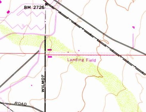
The 1975 USGS topo map depicted Allied Airfield as a single unpaved east/west runway, labeled simply as “Landing Field”.
The earliest aeronautical chart depiction of the Allied Airfield which has been located
was on the December 1976 Phoenix Sectional Chart (according to Chris Kennedy).

Allied Airfield, as depicted on the 1977 USGS topo map.
Bill Buel recalled, “I used to be employed by Allied Aircraft from 1980-83.
I am familiar with the old Allied airstrip as I use to jog it during my lunch breaks.
I had heard of the DC-4 crash that occurred there
and the reason it crashed was not from a tailwind
but rather the crew forgot to take out the elevator 'locks'.
As the plane was ready to rotate, there was no elevator.
I believe the pilot was injured when he broke his leg while jumping from the burning plane.”
Bill continued, “When I first started work there, the company had just rebuilt a C-124 (huge plane!).
It took off from Davis Monthan & we all were watching with anticipation at the Wilmot Road end of the runway.
It successfully flew over to Tucson International for FAA approval.
I heard that the original intent was to freight the plane in sections by truck to Las Vegas to be used as a restaurant.
But it would have been very costly removing power lines along the way...
it was cheaper to get it airworthy & fly it.”
Allied Aircraft was a great place for me to bring my kids to check out all the old aircraft:
Constellations, P-3s, F-104, A-4s.
One day they rolled in a flyable B-17 & stored it in front of my lab on the Allied property (Allied Precious Metals).
When everyone left I had a great time climbing through it.
It was destined for a museum back east & they needed a place to keep it for the night!”

The 1987 Flight Guide (courtesy of Jonathan Westerling) depicted Allied as a private airfield.
Jonathan noted, “It is unclear why the field only began appearing on charts long after its use as an airfield was all but curtailed.”

The 1990 Phoenix Sectional Chart (courtesy of Jonathan Westerling)
depicted Allied as a private airfield having a 3,400' unpaved runway.
The chart depicts the extremely strange relationship of having a private airfield practically right on the end of an 13,600' Air Force runway.
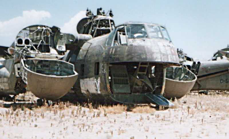
A 7/3/91 photo by John Sullivan (enhanced by Bill Grasha) of the remains of a Sikorsky CH-37B Mojave at the Allied yard.

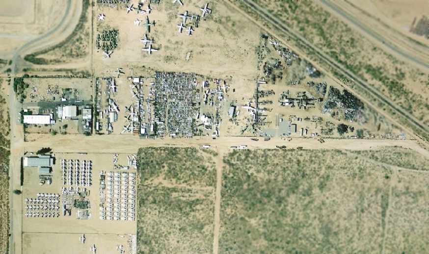
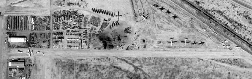
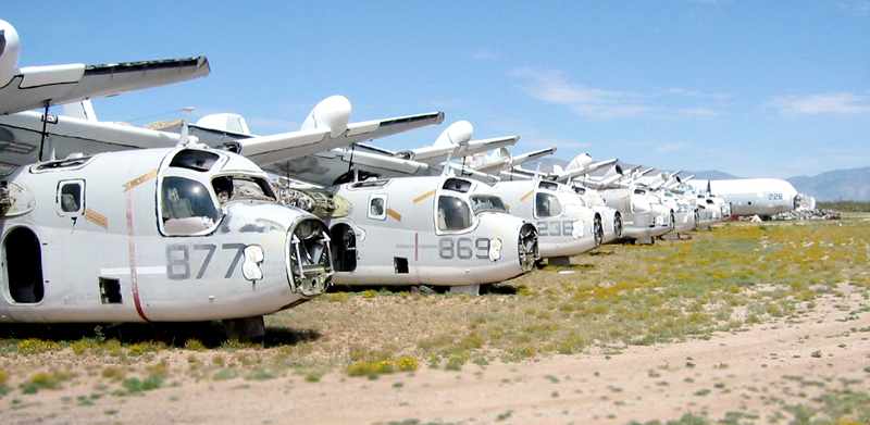
The 2002 USGS aerial photo depicted the former Allied runway, along with an amazing assortment of retired aircraft.
Jonathan Westerling reported in 2005, “According to the receptionist at Allied,
they have since sold their aircraft to other nearby companies (such as Kotz’s K-Tech Aviation)
but remain in business as Allied Precious Metals Recycling Company.”
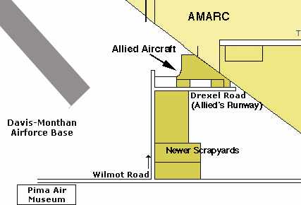
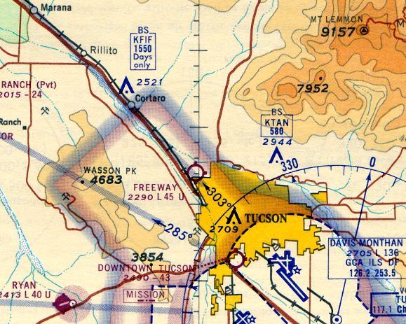
A 2005 diagram of the aviation bone yards in Tucson (courtesy of Jonathan Westerling)
indicating where the Allied Runway used to be, and its proximity to Davis-Monthan’s runway.

A 2005 photo by Jonathan Westerling, “Looking east along what used to be Allied Airstrip.
Today, powerlines & parked tractor-trailers indicate that it has been a while since planes took off here.”
A 2005 photo by Jonathan Westerling of a row of Grumman S-2 Trackers at the United Aeronautical Corporation on South Wilmot Road.
____________________________________________________
Macauley Field / Fishburn Field / Tucson Municipal Flying Field / Mayse Field, Tucson, AZ
32.17, -110.97 (North of Tucson International Airport, AZ)
An early-1920s aerial view looking northeast at the "Tucson Municipal Flying Field",
from the Bert Fireman Collection (courtesy of the AZ Historical Foundation, via Jonathan Westerling).
The very 1st municipal airport in the United States was located at this site in Tucson.
It was originally named Macauley Field.
According to a historical plaque placed at the site years later,
"Upon receipt of an official letter from Brigadier General Billy Mitchell of the U. S. Air Services
urging the City of Tucson to provide a municipal airport,
Mayor O.C. Parker & Allen B. Jaynes, president of the Chamber of Commerce appointed a Joint Committee consisting of the following members:
City of Tucson: O.C. Parker, R.E. Fishburn, H.S. Corbett, Stanley Kitt, Folsom Miere.
Chamber of Commerce: Allen B Jaynes, Orville S. McPherson, Monte Mansfield, Kirke Moore, C.J. Anderson.
The Committee purchased this 84 acre site from L. H Manning for $30 / acre.
A $5,000 loan from the Consolidated National Bank paid for the property & all necessary improvements & airport facilities."
Another plaque at the site read, "This Ground was the location of the 1st municipal airport in the United States.
The Tucson City Council approved the financing for the airport on 7/21/19,
and the City of Tucson in cooperation with the Tucson Chamber of Commerce established & constructed the airport."
The 7/26/19 issue of the Tucson Citizen (according to Jonathan Westerling) provided additional description:
"The field will be one of the finest in the country, with paving on 2 sides.
There is a siding at the field which will be used for postal purposes.
The 8-inch well affords an ample water supply, at the southwest corner of the field where the hangar,
accommodating 10 planes & machine shops will be erected.
The hangar & the shops will be furnished by the government.
The field will be completely enclosed by a barbed wire fence."
According to the historical plaque at the site, "The 1st plane landed on 11/20/19, Swede Myerhofer, Pilot."
The Tucson Citizen (according to Jonathan Westerling)
reported that on 11/20/19, "R. E. Fishburn, member of the aviation committee of the Chamber of Commerce,
who is in charge the construction of Macauley made the 1st landing in one of the Curtis Biplanes of the Barr Flying Circus."
[Fishburn was actually the honorary passenger on this 1st flight, which was piloted by Swede Myerhofer.]
The 82.6 acre airfield was constructed in a joint effort by the City & Chamber of Commerce at the behest of the War Department,
which was trying to seal the border from marauders & villianistas, supporters of Pancho Villa.
The airfield was originally named after Maj. T. C. Macauley,
an Army officer well known in Tucson & an early-day U.S. Air Service pilot.
Later, in 1920, the name of the airfield was changed to Fishburn Field
and then to the Tucson Municipal Flying Field.
In the airfield's first 4 years most of the planes using the field were Army patrol aircraft.
Border hostilities eventually waned & in 1923 the Army left & donated the 2 hangars & a living quarters to the city.
The only aeronautical chart depiction which has been located of Tucson Municipal Airport
was on a 1924 Air Navigation Map (courtesy of David Brooks).
Bill Gill reported, "We observed a photograph circa 1925 that showed the hangars in use with multiple aircraft parked on the property.
The 2 hangars displayed the business names 'Arizona Aircraft Company' (western hangar) and 'Airborne Inc.' (eastern hangar)."
By 1925, the airport was crowded with air traffic.
However, the strip was too soft & too short for takeoffs by newer, larger planes
so City officials acquired 1,280 acres east of Municipal Field & commenced on building a newer facility.
The city moved its airport, including one of the 2 hangars, in 1927 to the new site,
which it named Davis-Monthan Field (still in use today as Davis-Monthan AFB).
The old airport remained open for a few years.
Charles Mayse, a barnstormer & pilot for-hire, leased it in 1927 & ran a flying school & sightseeing tours from it.
It was at this point that the field was presumably renamed Mayse Field.

A 9/24/27 photo of Charles Lindbergh departing from the Tucson Municipal Flying Field.

The 8/21/29 Department of Commerce Airway Bulletin (courtesy of Jonathan Westerling)
described Mayse Field as a commercial airfield owned by the city, and operated by the Mayse Air Service.
The field was said to consist of an 80-acre, 2,000' square gravel field.
A 120' x 60' hangar (marked with “Mayse Airport”) & 2 other buildings were depicted on the southwest corner of the field.
The 1931 Commerce Department Descriptions of Airports Landing Fields in the U.S. (according to David Brooks)
described Mayse as a commercial field consisting of an 80-acre irregularly shaped gravel field, measuring 2,000' x 1,800',
with a single 2,450' north/south runway.
“Mayse Airport” was marked on top of a hangar.
The 1932 Air Navigation Map #30 (courtesy of Bill Johnston) no longer depicted Mayse Field.
Charles Mayse ran the field until the city closed it in 1933,
when the Rodeo Grounds were relocated back to the site of the airport.
The 1935 Phoenix Sectional Chart no longer depicted Mayse Field.
A 1958 aerial view showed that the fairground & rodeo grounds had taken over the site of the former airport.

An undated photo (from a 1970s issue of the Tucson Citizen, courtesy of Jonathan Westerling, enhanced by Bill Grasha)
of a flagpole which stood at the site of the Tucson Municipal Flying Field
which contained a historical plaque installed in 1933,
when the Municipal Rodeo was moved back to the site.
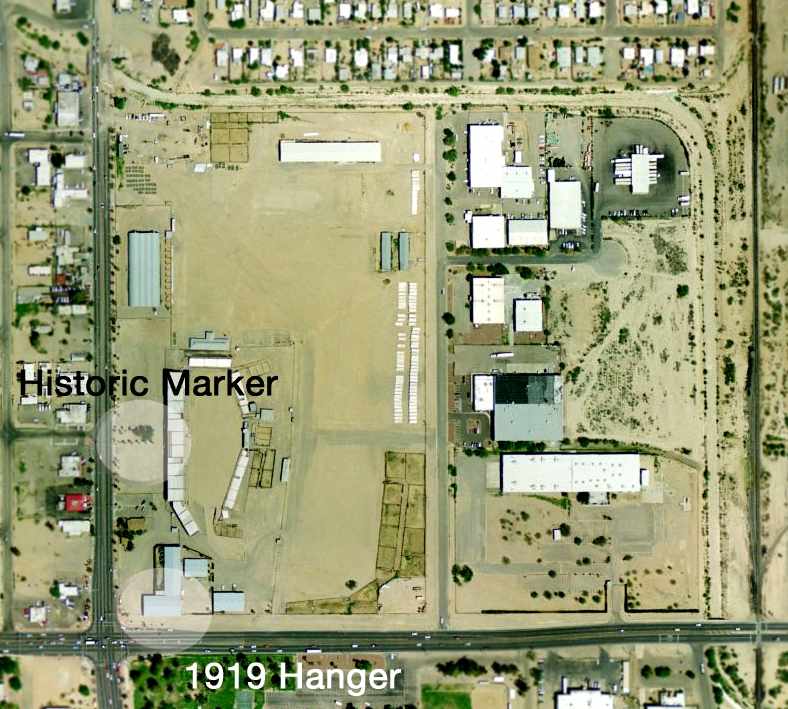
The 2002 USGS aerial photo of the site of the former Tucson Municipal Airport has been annotated by Jonathan Westerling
to show the location of the historical marker & the former hangar.
There are no discernible remains of any runways.
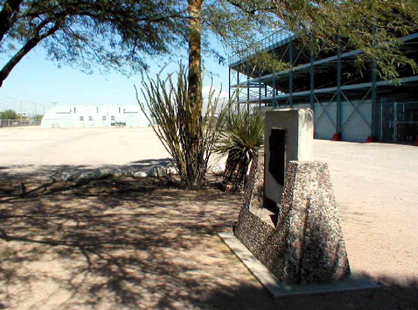
A November 2004 photo by Jonathan Westerling of the historical marker at the site of the former Tucson Municipal Airport.

A November 2004 photo by Jonathan Westerling of the plaque on one side of the historical marker.

A November 2004 photo by Jonathan Westerling of the plaque on the other side of the historical marker.
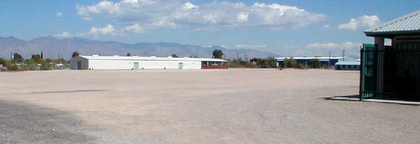
A November 2004 photo by Jonathan Westerling of former hangar from the Tucson Municipal Flying Field,
now on the site of the Pima County Fairgrounds & Tucson Rodeo Grounds.
"It's hard to believe, but the hangar of the first municipal airport in the US is still standing."
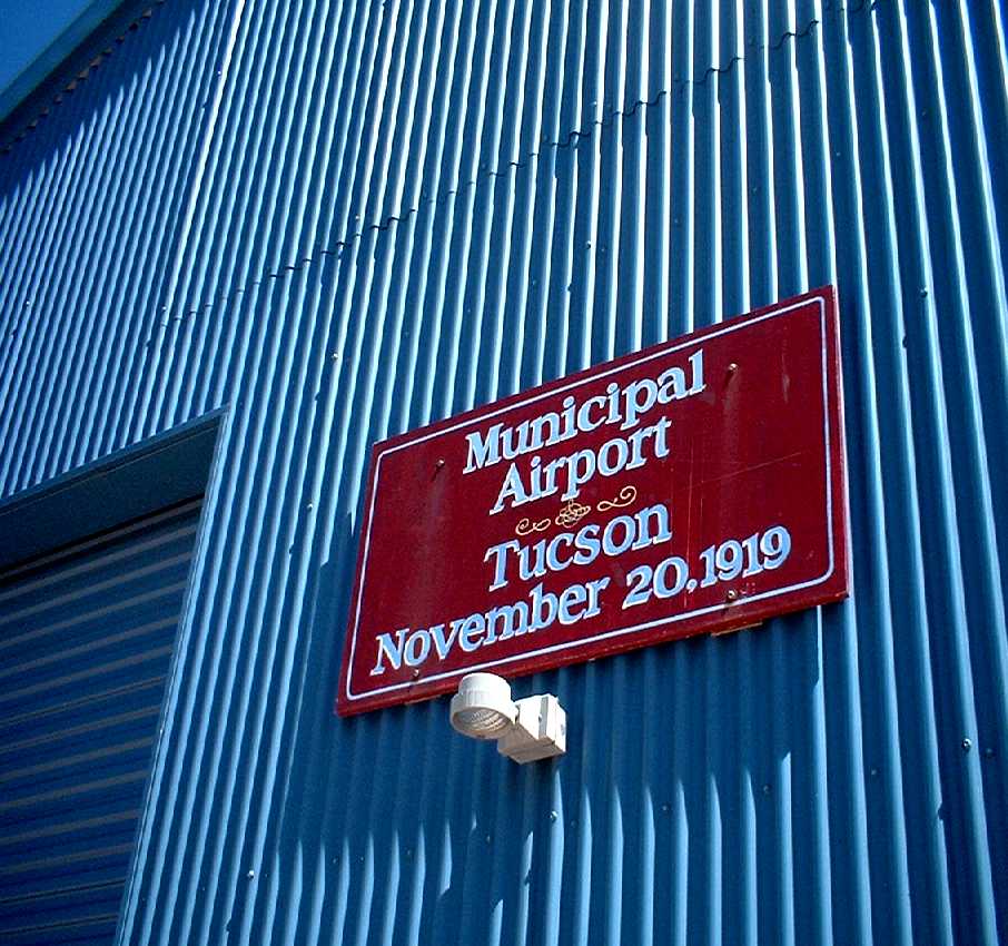
A March 2012 photo by David Westerling of the sign commemorating the 11/20/19 hangar of the Tucson Municipal Airport.
Jonathan Westerling observed, “The city has restored the hangar, retaining the original steel beams & frame.
The outside cladding on the hangar has been replaced.
Thankfully the sign commemorating the significance of the structure was also repainted & affixed to the outside of the building.”
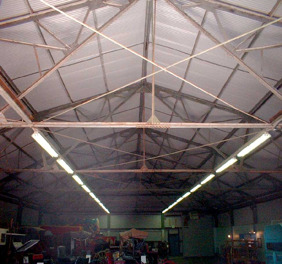
A March 2012 photo by David Westerling of the interior of the 11/20/19 hangar of the Tucson Municipal Airport.
The site of the Tucson Municipal Flying Field is located northeast of the intersection of South 6th Avenue & East Irvington Avenue.
____________________________________________________
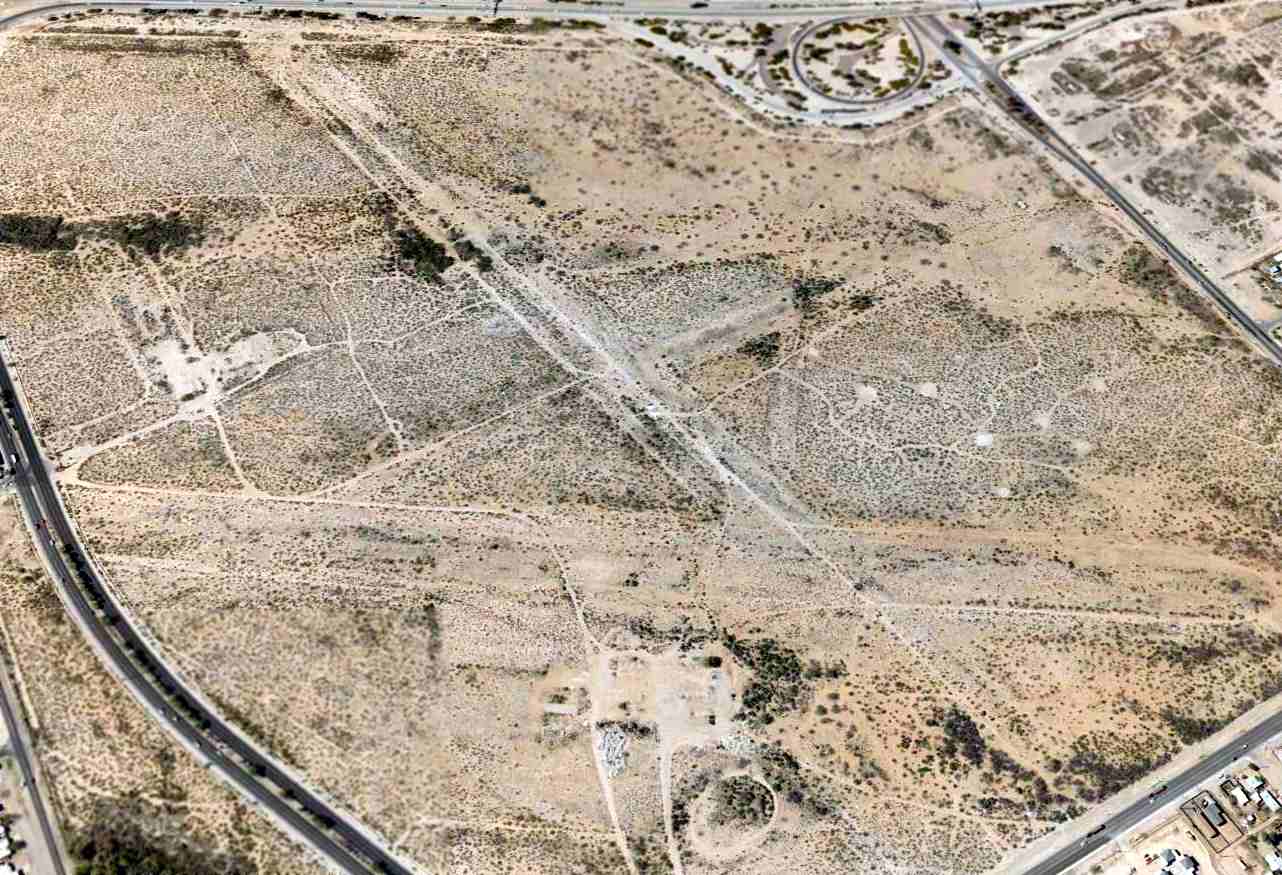
Tucson Airport / Downtown Tucson Airport (2SE), Tucson, AZ
32.19, -110.95 (North of Tucson International Airport, AZ)

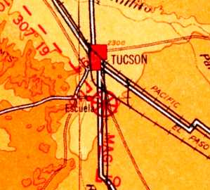
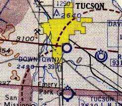
What was simply labeled “Tucson” Airport, as depicted on the September 1941 Phoenix Sectional Chart (courtesy of Chris Kennedy).
An airfield was evidently established on this spot at some point between 1937-41,
as no airfield was listed at this location in The Airport Directory Company's 1937 Airport Directory (courtesy of Bob Rambo).
The earliest depiction which has been located of an airfield at this location
was on the September 1941 Phoenix Sectional Chart (courtesy of Chris Kennedy).
It depicted “Tucson” Airport as a commercial or municipal field.
The Tucson Airport at this location was evidently closed at some point between 1941-43 (possibly due to the war),
as no airfield at this spot was depicted on the 1943 Phoenix Sectional Chart (according to Chris Kennedy)
or the 1945 Phoenix Sectional Chart (courtesy of John Voss)
nor listed among active airfields in the 1945 AAF Airfield Directory (courtesy of Scott Murdock).

At some point between 1945-49, this airfield was evidently reopened as “Tucson Downtown Airport”,
as that is how it was depicted on the March 1949 Phoenix Sectional Chart (courtesy of Chris Kennedy).
The field was depicted as having a 4,200' unpaved runway.
The 1956 Phoenix Sectional Chart (courtesy of John Voss)
depicted Tucson Downtown Airport as having a 3,900' unpaved runway.
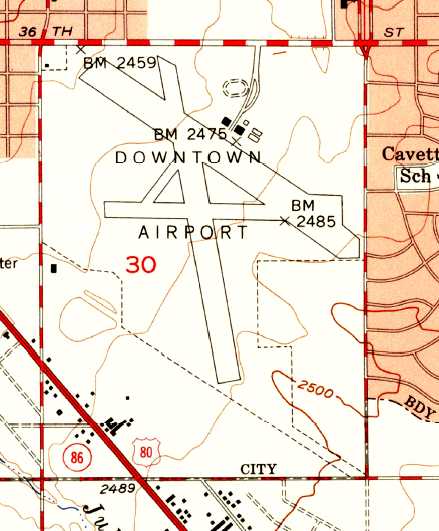
The 1957 USGS topo map depicted Tucson Downtown Airport as having 3 runways, with several buildings on the northeast side.

A December 1957 photo of an amazing sight: dozens (hundreds?) of surplus AT-6 Texans awaiting scrapping at Tucson Downtown Airport.
Today such an assemblage of warbirds would be worth millions of dollars.

The earliest aerial photo which has been located of Tucson Downtown Airport was a 1958 aerial view.
It depicted Tucson Downtown as having 2 unpaved runways, along with the remnants of a former east/west runway.
Three hangars were located on the northeast side of the field.
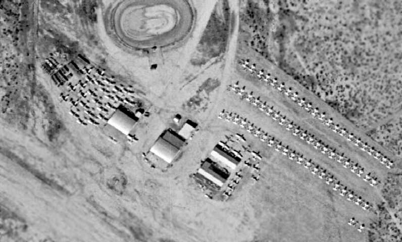
A closeup from the 1958 aerial view shows that Tucson Downtown Airport
was evidently being used as a “boneyard” to store surplus military aircraft,
as an amazing assemblage of over a hundred aircraft was visible on the field,
including large numbers of what appeared to be single-engine aircraft either with their wings removed or folded.
The 1962 AOPA Airport Directory described Downtown Airport
as having 3 unpaved runways (the longest being 4,300'),
and listed the operator as John Smedley.
An article entitled "Downtown Airport Will Reopen" by Larry Sellers
appeared in the 1/26/64 issue of the Arizona Daily Star (courtesy of John Cramer).
"Lawrence & Edell Murray, a husband & wife team, are in the process of re-opening Downtown Airport,
located at South Park & 36th Street.
After weeks of intensive clean-up operations, grading of runways & taxiways & general clearing work
the Murrays are now progressing on their new aircraft repair shop business,
known as Murray's Aircraft Service.
The runway is 4,200' in length.
Acres of tie-down space are open & 80/87 fuel is available."
The last aeronautical chart depiction which has been located of Downtown Tucson Airport
was on the July 1965 Phoenix Sectional Chart (courtesy of Ron Kunse).
It depicted Downtown Tucson Airport as having a 4,300' unpaved runway.

The only ground-level photo which has been located of an aircraft at Tucson Downtown Airport
was a 1966 photo by Brian Baker of Piper PA-25 sprayer N6165Z in front of the hangars.
Downtown Tucson Airport was still listed as an active airport in the 1972 Flight Guide (courtesy of Chris Kennedy).
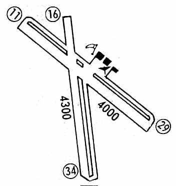
It was described as "attended days; closed nights",
and depicted as having 2 unpaved runways (4,300' Runway 16/34 & 4,000' Runway 11/29),
each with a parallel taxiway, and 3 buildings (hangars?) east of the runway intersection.
The last photo which has been located showing Tucson Downtown Airport while in operation was a 1972 aerial view.
It depicted only a single aircraft on the ramp in front of the hangars.
According to the 2001 Tucson Citizen article,
the 350-acre Downtown Airport property was bought by Little America Refining Company for $3.7 million in 1973.
The 1974 Flight Guide (courtesy of Fred Udall) described Downtown Tucson Airport as having 2 unpaved runways.
According to the 2001 Tucson Citizen article, in 1975 Little America Refining Company officials announced plans to build a major hotel/resort on the site.
However, these plans were not carried out, and the airport continued to operate for a short while more.
Tucson Downtown was described in the 1976 AOPA Airport Directory (courtesy of Chris Kennedy)
as having 2 dirt runways (4,300' 15/33 & 4,000' 12/30).
However, the status of the airport had apparently changed to a private field
when the property had been purchased a few years prior by Little America Refining Company,
as the remarks said, "Private airport. Use at own risk."
Tucson Downtown apparently closed in 1976,
as it was not listed in the 1976 Flight Guide (courtesy of Alex Hauzer).
It was still depicted as Downtown Tucson Airport on the 1977 USGS topo map,
but did not appear on later topo maps,
and was not depicted at all (even as an abandoned airfield) on later aeronautical charts.
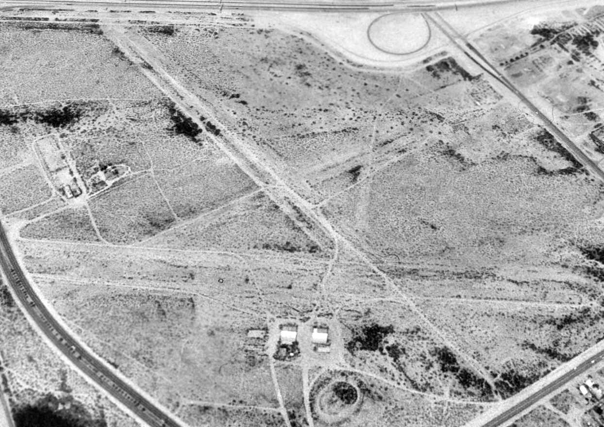
A 1992 USGS aerial view looking southwest showed Tucson Downtown Airport to remain almost completely intact.
In addition to the 2 runways depicted on the 1972 Flight Guide, the outline of a third (east/west) runway was also apparent.
Two of the former 3 airport buildings were still standing.
According to the 2001 Tucson Citizen article,
the site of Downtown Airport had "become overgrown with desert broom & creosote.
A few weathered aluminum hangars are visible from the city roads that now encircle the once-remote location.
The Tucson property hasn't been developed because the company
[property owner Little America Refining Company, a subsidiary of Sinclair Oil]
has been busy with major projects elsewhere,
said Christian Peterson, director of real estate for Sinclair Oil.
'Raw land' parcels such as the Tucson site are part of the company's long-term investment strategy, Peterson said.
The land has not been forgotten in corporate files.
A hotel or other major development project may still be undertaken at the old airport site in the future, Peterson said.
Or the property could be sold if the right offer is made."
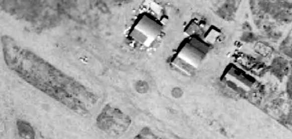
A close-up of the former hangars from the October 2002 USGS aerial photo.
John Cramer reported in 2004, "Today the hangers are used for something,
but I have not been able to find out what.
The property is ringed with 'No Trespassing' signs,
probably to prevent wildcat dumping in the desert.
I have seen pickup trucks going in & out of the property as well
(I go by it twice a day on my way to & from work)."

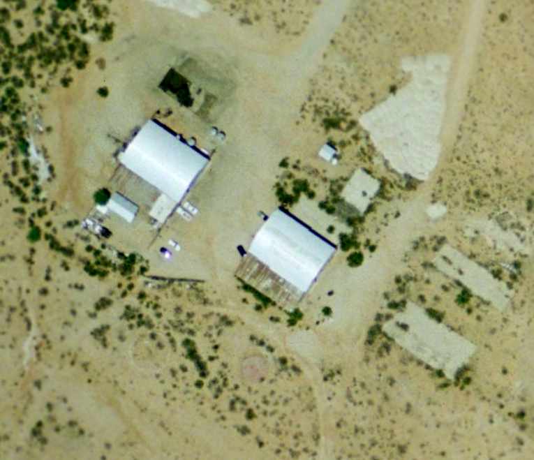
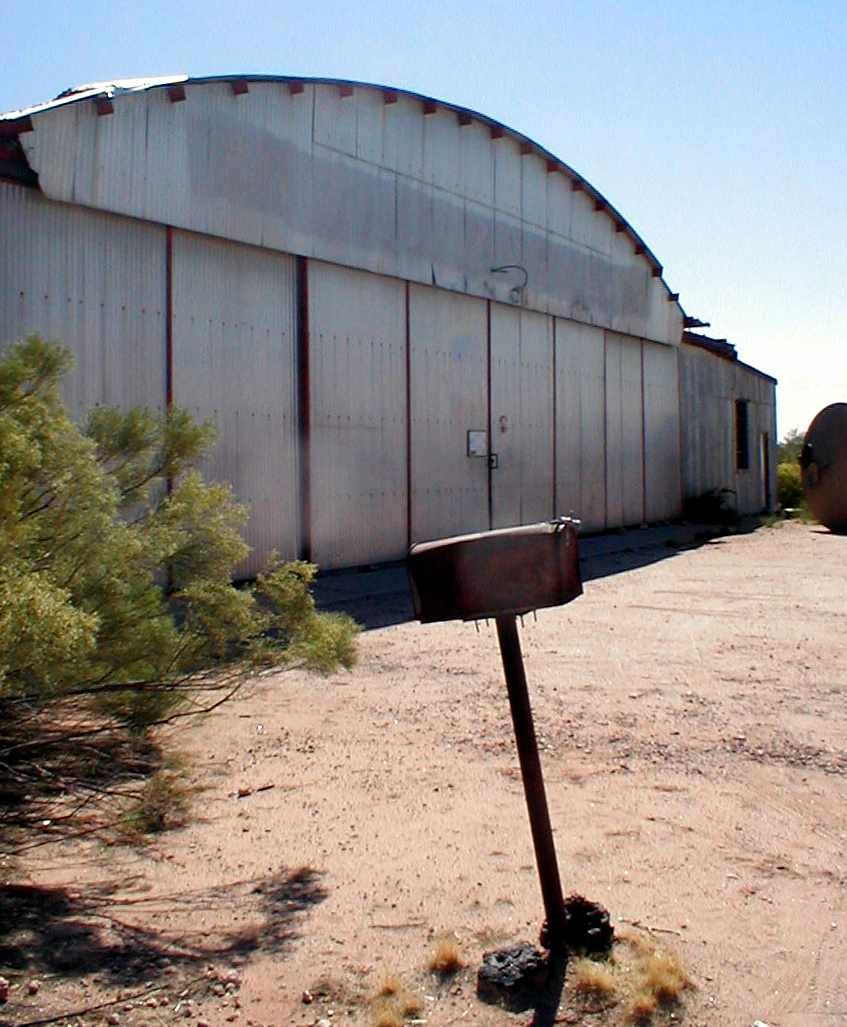
A November 2004 photo by Jonathan Westerling of the front of the former Hangar #1,
reused as the home of the Busy D Pumping Company.
Jonathan Westerling visited the site of Tucson Downtown Airport in November 2004.
"It's always nice to hit paydirt when looking for old airports.
Sometimes paydirt is an untouched site.
Sometimes it's being able to go inside the buildings that were once bustling with aviation.
In the case of Downtown airport, it was both!"
"I found the site of the Downtown Tucson airport pretty much still undisturbed since it was abandoned in 1977.
Two of the 3 hangars remain standing.
Hangar #2 is vacant, the other houses the 'Busy D Pumping' company.
The Manager was kind enough to spend some time with me relating the history of the buildings.
He showed me inside Hangar #1 where they have converted the space into a wastewater processing plant."

A November 2004 photo by Jonathan Westerling of the front of the abandoned former Hangar #2.
A November 2004 photo by Jonathan Westerling of the back of the abandoned former Hangar #2,
"on a beautiful autumn Arizona day."

A November 2004 photo by Jonathan Westerling of the back of the abandoned former Hangar #2,
A November 2004 photo by Jonathan Westerling.
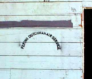
"Inside Hangar #2, I found "The Flying Dutchman Air Service" stenciled on a wall - perhaps the local FBO?"
A November 2004 photo by Jonathan Westerling.
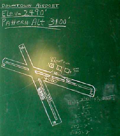
"In a back room, I discovered a chalkboard on the wall behind a large bookshelf.
On it was drawn a chart of the airport layout along with runway lengths & numbers,
perhaps drawn by Mr. or Mrs. Murray?"
It depicted the field as having a 4,300' Runway 16/34 & a 4,000' Runway 11/29, both of which also had parallel taxiways.
A total of 3 buildings were depicted just northeast of the runway intersection.
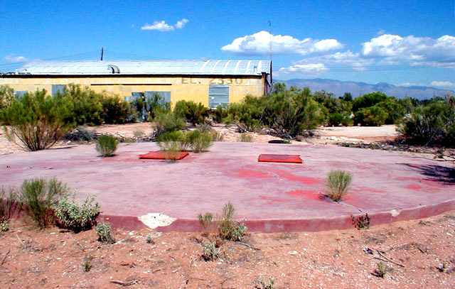
A November 2004 photo by Jonathan Westerling.
"Out back, the red concrete fuel pad was easily identifiable
with both pumps appearing ready to meter out many more gallons."
A November 2004 photo by Jonathan Westerling.
"Looking inside one of the hatches you can easily see that the pumps inside are in good condition."

A November 2004 photo by Jonathan Westerling looking southeast
along the abandoned former Runway 11, "now well overgrown with desert shrubbery."

A
November 2004 photo by Jonathan Westerling looking southeast along
the abandoned former Runway 16.
Jonathan
Westerling reported in 2004, "The manager mentioned that they
had just received notice to vacate
since that the site had been sold again
and is slated to be bulldozed in a few weeks to make way for a subdivision.
He seemed skeptical that he would be able to move his entire operation within the month,
but acknowledged that they knew their lease was limited at that location.
It was only a matter of time, I suppose, that this airport site would be reused.
What with its proximity to Tucson International, and the bustling Davis-Monthan Air Force Base,
it was unlikely that Tucson Downtown Airport was going to be reborn.
Too bad this piece of history is soon to become a memory."
A circa 2005 aerial view looking west at a building on the south side of the site of Tucson Downtown Airport.
What purpose did this building serve?
A circa 2005 aerial view looking west at the 2 remaining former hangars on the north side of the site of Tucson Downtown Airport.

Unfortunately a slightly later aerial photo (circa 2006?) looking east at the same pair of hangars
shows that the majority of their roofs & walls have been removed.
According to an article entitled “Bioscience park a tech boost?” by David Pitman in the 6/21/06 issue of the Tucson Citizen,
the former airport property was sold in 2005 by the Sinclair Oil Company to a group of developers,
who are hoping to redevelop the site into a massive “Bioscience park”,
touted as “the largest infill project in Tucson's history.”
A 2008 aerial view looking southwest showed Tucson Downtown Airport's hangars had been removed, but the runway layout was still recognizable.

A 2014 aerial view looking southwest showed all traces of Tucson Downtown Airport had been removed by new construction.
The site of Downtown Airport is bounded by Interstate 10 on the south, East 36th Street on the north,
South Park Avenue on the west, and South Kino Parkway on the east.
____________________________________________________
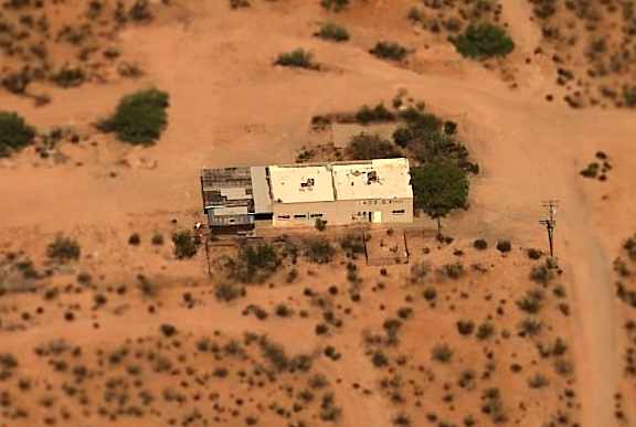
Sahuarita AF Flight Strip, Sahuarita, AZ
31.97, -110.92 (South of Tucson, AZ)
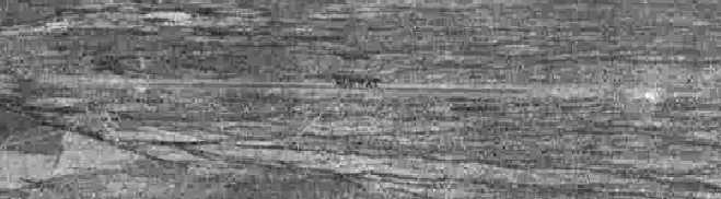
A 5/5/43 aerial view looking northeast at “Davis-Monthan Field Auxiliary (Sahuarita Flight Strip)”
from the 1945 AAF Airfield Directory (courtesy of Scott Murdock).
This military airfield was located within the 27,000 acre Sahuarita Bombing & Gunnery Range.
The bombing range predated the airfield;
the range was first used in April 1942 by aircraft from Davis-Monthan Field.
According to a 1943 table of 2nd Air Force Flight Strips (courtesy of John Voss),
construction of the the Sahuarita Flight Strip was completed in 1943,
and it had a 5,400' paved runway.
The Commanding Officer at Davis-Monthan Field requested the closing
of the Air-to-Ground Gunnery Range at Sahuarita in the same year
due to its dangerously close location to the Flight Strip.
The earliest depiction which has been located of the Sahuarita Flight Strip
was a 5/5/43 aerial view looking northeast at “Davis-Monthan Field Auxiliary (Sahuarita Flight Strip)”
from the 1945 AAF Airfield Directory (courtesy of Scott Murdock).
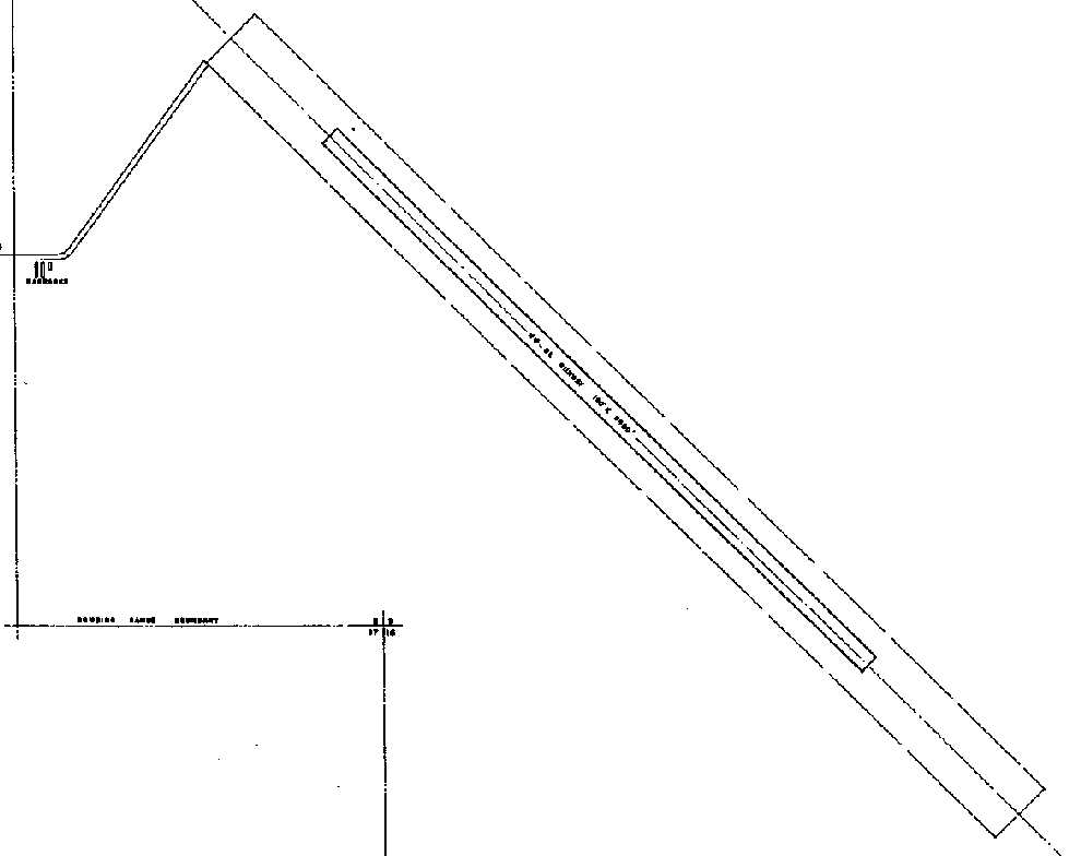
A 5/1/44 plan from a 2nd Air Force Directory of Army Airfields (courtesy of Ron Plante)
depicted Sahuarita Flight Strip as having a single northwest/southeast paved runway,
with a cluster of 3 small barracks along the entrance road to the west.

The earliest aeronautical chart depiction which has been located of the Sahuarita Flight Strip
was on the March 1945 Douglas Section Chart (courtesy of Chris Kennedy).
It depicted the “Sahuarita FS” as having a single northwest/southeast runway.
The 1945 AAF Airfield Directory (courtesy of Scott Murdock) described “Davis-Monthan Field Auxiliary (Sahuarita Flight Strip)”
as a 193 acre rectangular property having a single 5,400' bituminous northwest/southeast runway.
The field was not said to have any hangars,
to be owned by the U.S. Government, and operated by the Army Air Forces.
After WW2 the runway was used for emergency landings.
In 1950, bomber crews from Carswell AFB, TX,
conducted many of the bombing missions flown on the Sahuarita Range.
The Strategic Air Command retained the Flight Strip for emergencies on the range
even though it was dangerously close to the firing & bombing targets.
Jet assisted take-off (JATO) bottles have been found in the runway area.
The airfield was labeled "Sahuarita FS (AF)" on the 1956 Phoenix Sectional Aeronautical Chart (courtesy of John Voss).
It is depicted as a 5,400' hard-surface runway.
The airspace over the field was protected by its own Restricted Area, R-310.

The 1958 USGS topo map depicted Sahuarita as a single paved northwest/southeast runway, labeled simply as “Landing Strip”.

A 1958 aerial view depicted Sahuarita as consisting of a single paved northwest/southeast runway.
There did not appear to have been any hangars or any other improvements.
Use of the Sahuarita runway was reportedly discontinued in 1962,
and it was classified as an emergency landing strip.
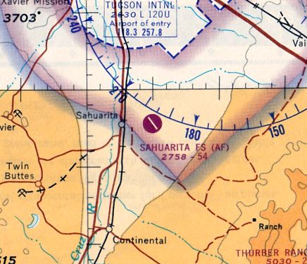
"Sahuarita FS (AF)" was still depicted as an active airfield on the October 1965 Douglas Sectional Chart (courtesy of Ron Kunse).
It depicted Sahuarita as having a single paved 5,400' northwest/southeast runway.
"Sahuarita FS (AF)" was still depicted as an active airfield
on the 1966 Douglas Sectional Chart (according to Chris Kennedy).
Curiously, the Aerodromes table on the chart incorrectly lists it as "Sahuarita, Mex.",
and the Remarks say "Information incomplete".
The final portions of the Sahuarita Range were released by the federal government in 1978.
The Flight Strip property is currently owned by the State of AZ, and leased to a cattle rancher.
The 1981 USGS topo map depicted the airfield, labeled simply "Landing Strip".
It also showed that the southeastern end of the runway had been bisected by East Sahuarita Road at some point between 1958-81.
The 1994 USGS topo map depicted the airfield, labeled simply "Landing Strip".
The 1996 USGS aerial photo showed that a ball park had been built on the northern end of the former runway,
and South Sahuarita Park Road has been built over the majority of the runway.
Steve Belle recalled, “I worked on the construction of Sahuarita Park.
We simply powerbroomed the dirt of the surface of the old runway & chip-sealed over it.
The north end was at the point where the road goes into the park gate. It was nice not have to destroy the history.”
The Sahuarita Flight Strip was not depicted at all (even as an abandoned airfield) on 2002 aeronautical charts.
John Sparks reported in 2003 that "The strip has been broken into 3 different parcels:
the north end is owned by Pima County Parks;
the other two (the center & south end) are held by Arizona State Land Department.
The airstrip itself is being used as a road called Sahuarita Park Road.
I am assuming it is used to get to the ball park from Sahuarita Road,
although there appears to be an entrance off a dirt road on the north end.
The large gray area on the northeast side is a power sub-station."

An October 2004 photo by Tim Tyler of the entrance to Sahuarita Park, looking along the former runway.
Tim Tyler visited the site of the Sahuarita Flight Strip in October of 2004.
His report: "The southwest end is now Sahuarita Park, with various ball fields.
The former runway seems to now be Sahuarita Park Road,
running west-southwest off of Sahuarita Road to the park.
Street Atlas shows that the road is separate,
and running immediately parallel to the South of the former runway,
but looking off from the road, all I saw was desert brush,
with no access roads besides a dirt road toward the west-southwest end of the runway,
following some high voltage lines."
Tim Tyler continued, "The road was perfectly flat & straight for roughly a mile, but just the standard width of a paved country road.
We traveled North down the dirt road for about half a mile,
and saw nothing expect the high voltage lines & a transformer station.
The former Sahuarita AF Bombing & Gunnery Range was just to the east of the airfield.
After we got back on Sahuarita Road we headed north on it
and looked off to our left for any access road or whatever, but didn’t see anything besides the brush.
There was a small cattle fence along the road,
but it didn’t have any sort of unexploded ordnance warning signs."

A May 2005 aerial view looking southeast along the remains of the Sahuarita runway,
showing the park built over the northeastern end.
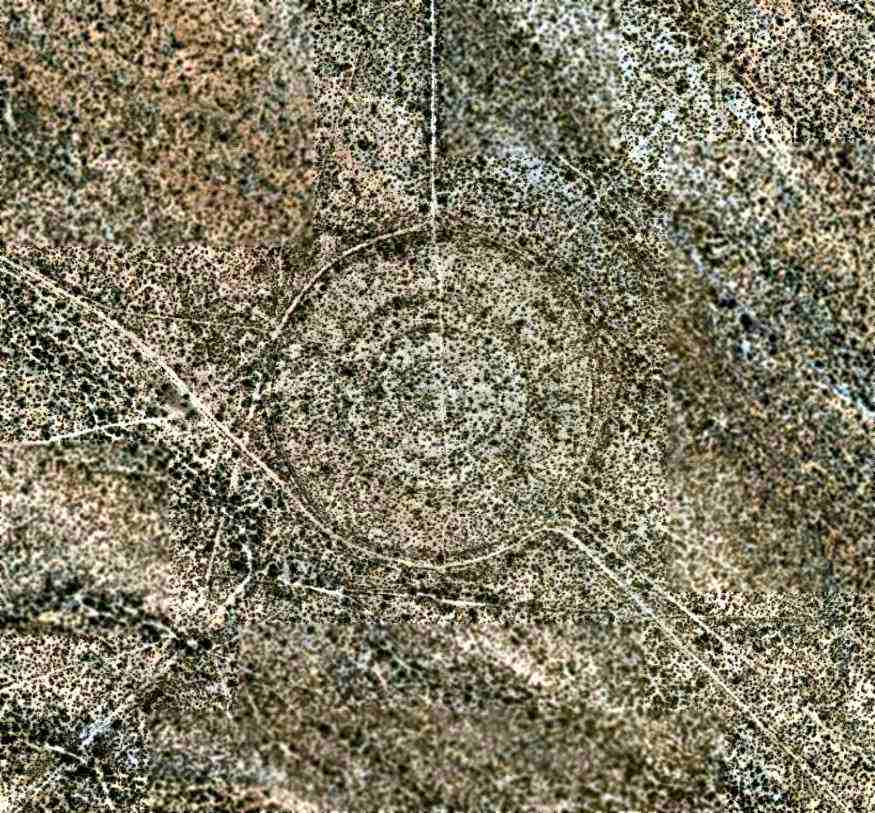
A May 2005 aerial view (courtesy of Robert McHugh) of a circular bomb target which sits 2.3 NM southeast of the end of the Sahuarita runway.
An unpaved road leads straight along the runway alignment from the end of the runway to the target.
A circa 2006 aerial view looking north at the remains of the south end of the Sahuarita runway,
showing South Sahuarita Park Road overlaid on the former runway.
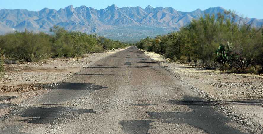
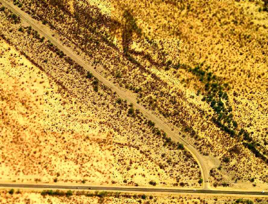
An October 27, 2007 photo by Brian Basgen looking southeast along the former Sahuarita runway,
with the Santa Rita Mountains in the background.
The airfield is located northeast of the intersection of East Sahuarita Road & South County Club Road,
two miles east of Sahuarita.
____________________________________________________
Since this site was first put on the web in 1999, its popularity has grown tremendously.
That has caused it to often exceed bandwidth limitations
set by the company which I pay to host it on the web.
If the total quantity of material on this site is to continue to grow,
it will require ever-increasing funding to pay its expenses.
Therefore, I request financial contributions from site visitors,
to help defray the increasing costs of the site
and ensure that it continues to be available & to grow.
What would you pay for a good aviation magazine, or a good aviation book?
Please consider a donation of an equivalent amount, at the least.
This site is not supported by commercial advertising –
it is purely supported by donations.
If you enjoy the site, and would like to make a financial contribution,
you
may use a credit card via
![]() ,
using one of 2 methods:
,
using one of 2 methods:
To make a one-time donation of an amount of your choice:
Or you can sign up for a $10 monthly subscription to help support the site on an ongoing basis:
Or if you prefer to contact me directly concerning a contribution (for a mailing address to send a check),
please contact me at: paulandterryfreeman@gmail.com
If you enjoy this web site, please support it with a financial contribution.
This site covers airfields in all 50 states.