
Abandoned & Little-Known Airfields:
California: Eastern San Diego County
© 2002, © 2016 by Paul Freeman. Revised 12/3/16.
This site covers airfields in all 50 states: Click here for the site's main menu.
____________________________________________________
Please consider a financial contribution to support the continued growth & operation of this site.
Borrego Hotel NOLF (revised 2/18/06) - Clark's Dry Lake NOLF (revised 8/3/13) - Ensign Ranch Airfield (revised 12/3/16) - Rancho del Otay Airfield (added 10/30/13)
____________________________________________________
Ensign Ranch Airfield, Borrego Springs, CA
33.233, -116.357 (East of San Diego, CA)

Ensign Ranch Airfield, as depicted on a 4/21/54 USGS aerial view.
According to the Journal of San Diego History (courtesy of Kurtis Clark),
“O.H. Ensign, a Los Angeles carburetor manufacturer, was the first large-scale rancher to begin farming in Borrego Valley.
In 1926 he acquired some land near the center of the valley, drilled a well, and began raising alfalfa, hogs, and turkeys.
In 1927 he added a small date palm nursery, setting out more shoots in 1928.
In 1933 he planted an 8-acre date palm orchard of his own.
Disease-bearing pests were already common in the date groves of the Coachella Valley, but Ensign's ranch was isolated,
and by specially treating the shoots before planting he was able to maintain the only pest-free date grove in California.
By 1942 they were harvesting more than 40,000 pounds of dates / year.”
In 1943 Marines established a formal base at the Ensign Ranch, known as Camp Ensign.
At some point an airfield was established on the Ensign Ranch.
The earliest depiction which has been located of Ensign Ranch Airfield was a 4/21/54 USGS aerial view.
It depicted a single northwest/southeast unpaved runway, with the ranch to the northeast.
There did not appear to be any hangars or aircraft visible on the field.

The last photo which has been located of Ensign Ranch Airfield was a 10/21/56 USGS aerial view looking north.
It depicted a single northwest/southeast unpaved runway, with the ranch to the northeast.
There did not appear to be any hangars or aircraft visible on the field.
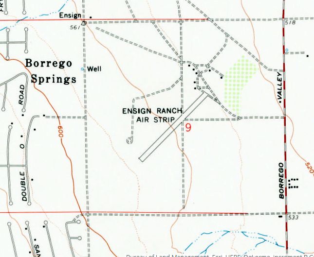
The 1959 USGS topo map depicted Ensign Ranch Air Strip as a single northwest/southeast unpaved runway, with a few small buildings to the northeast.
Ensign Ranch Airfield was not depicted at all on the August 1965 San Diego Sectional Chart (courtesy of Ron Kunse).
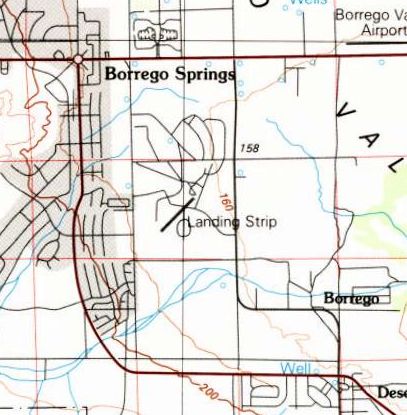
The last depiction which has been located of Ensign Ranch Airfield was on the 1982 USGS topo map.
It depicted a single northwest/southeast runway, labeled simply as “Landing Strip”.
Ensign Ranch Airfield was evidently closed at some point between 1982-94,
as a 1994 USGS aerial photo showed a golf course covering the site of the airfield.
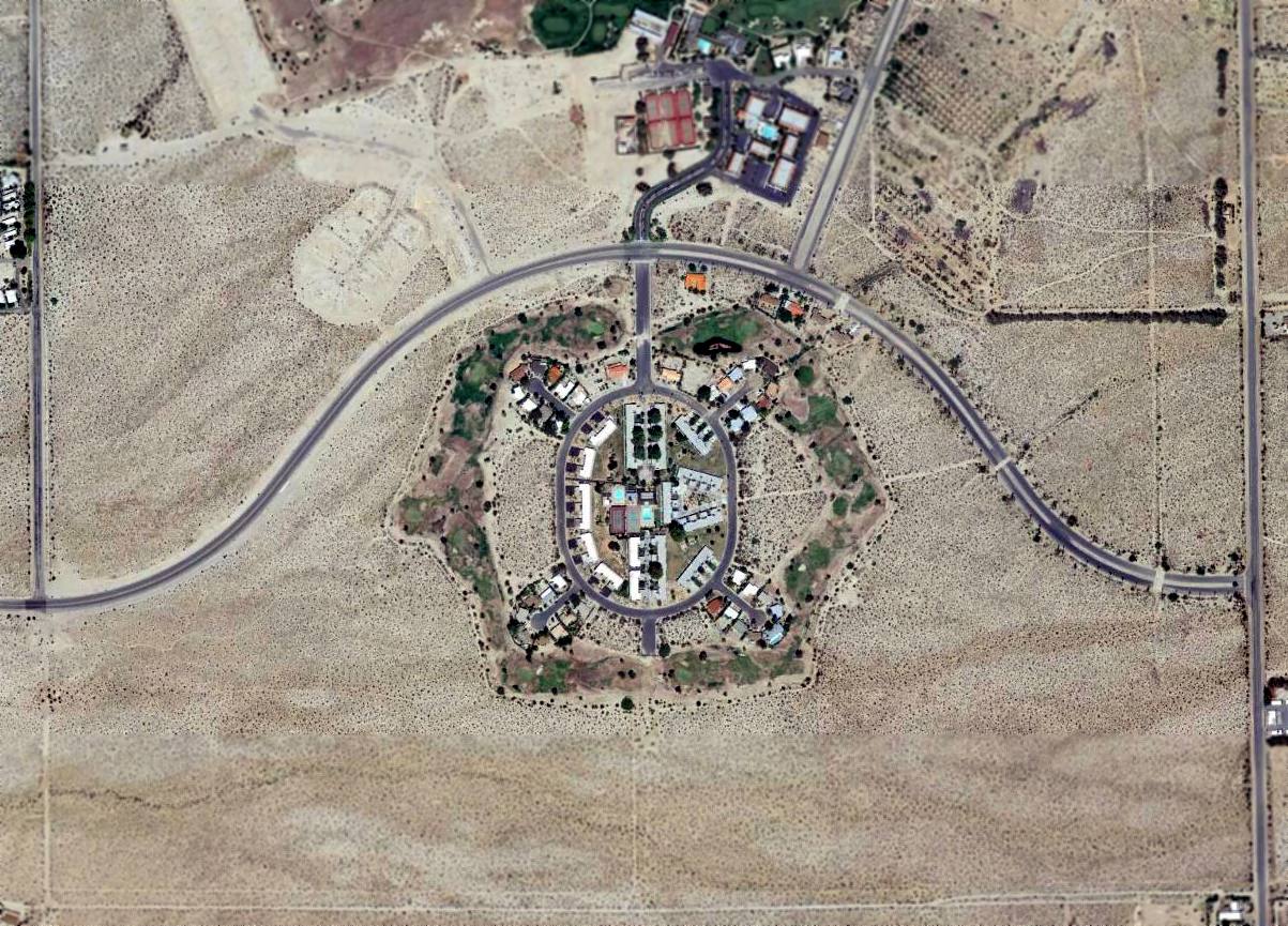
A 2014 aerial view showed no trace remaining of Ensign Ranch Airfield, with a golf course community covering the property.
The site of Ensign Ranch Airfield is located east of the intersection of Borrego Springs Road & Tilting T Drive.
Thanks to Kurtis Clark for pointing out this airfield.
____________________________________________________
Rancho del Otay Airfield, Chula Vista, CA
32.646, -116.942 (East of San Diego, CA)
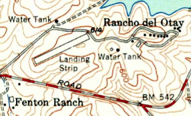
Rancho del Otay Airfield, as depicted on the 1955 USGS topo map.
Photo of the airfield while in use has not been located.
Rancho del Otay was part of a vast 29,000 acre estate owned by industrialist Stephen Birch.
After his death in 1940, an 11 acre portion at Rancho del Otay became the home of his daughter Mary,
who ferried planes to England during WW2.
At some point Mary constructed a short runway on her property.
No airfield was yet depicted on the property on the 1943 USGS topo map.
The earliest depiction which has been located of the Rancho del Otay Airfield was on the 1955 USGS topo map.
It depicted a short northeast/southwest runway adjacent to the west side of the ranch buildings, labeled simply as “Landing Strip”.
Rancho del Otay Airfield was not depicted at all on the August 1965 San Diego Sectional Chart (courtesy of Ron Kunse).

The earliest photo which has been located of the Rancho del Otay Airfield was an 8/28/71 USGS aerial photo.
It depicted a short northeast/southwest runway, with a small ramp on the east side.
There did not appear to be any hangars, nor any aircraft visible on the field.
Mary Birch died in 1983, and her ranch was sold to the Baldwin Company for development in 1988.
But her enormous estate, divvied up among relatives, friends, and former employees, became mired in lawsuits.
The result was the longest probate case in San Diego County history.
The 1998 USGS topo map still depicted a short northeast/southwest runway adjacent to the west side of the ranch buildings, labeled simply as “Landing Strip”.

Amazingly a 11/12/12 aerial view looking west still shows the Rancho del Otay runway outline remaining recognizable,
even though dense housing surrounds the property.
Rancho del Otay Airfield is located east of the intersection of Otay Lakes Drive & Woods Road.
Thanks to Richard Scheid for pointing out this airfield.
____________________________________________________
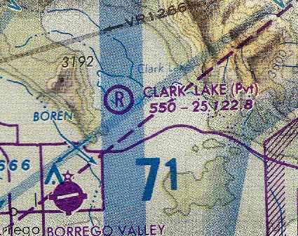
Clark's Dry Lake Naval Outlying Landing Field, Borrego Springs, CA
33.336, -116.289 (Northeast of San Diego, CA)

“Clark’s Dry Lake Emergency Landing Field / Field #05169”,
as depicted in a circa 1944 directory of NAS San Diego airfields (courtesy of Brian Rehwinkel).
Photo of the airfield while in use has not been located.
The date of establishment of the Clark's Dry Lake Airfield has not been determined.
It occupies the western portion of Clark's Dry Lake.
The earliest depiction of the field which has been located
was on a June 1938 map of Leased Auxiliary Airfields for NAS San Diego (according to Brian Rehwinkel).
It was not yet depicted at all on the March 1944 San Diego Sectional Chart (according to Chris Kennedy).
However, a table of CA Airports listed Clarks Dry Lake as being an active airfield in 1944.
A circa 1944 directory of NAS San Diego airfields (courtesy of Brian Rehwinkel)
depicted the “Clark’s Dry Lake Emergency Landing Field / Field #05169”
as having 2 compact sandy silt & clay runways, 9/27 & 13/31, each 5,000' long.
A bombing target was depicted northeast of the runway intersection.
The field was said to be assigned for administrative & maintenance purposes to NAAS Salton Sea.
According to Bill Haneline, the cement structures that were built on the lake “are the 'Rakes'.
Personnel sat in these & scored target practice [using] a device that reminded people of a rake.
They were in radio communication with the aircraft. It must have been hell in them during the summer.”
During WW2, Clarks Dry Lake NOLF was used
as one of at least 12 auxiliary airfields attached to San Diego NAS (North Island).

The earliest aeronautical chart depiction which has been located of the Clark's Dry Lake airfield
was on the March 1945 San Diego Sectional Chart (courtesy of Chris Kennedy).
It depicted "Clark's Dry Lake (Navy)" as an auxiliary airfield,
located on the northwest corner of the lakebed.
A 1997 Army Corps of Engineers report stated that Clarks Dry Lake was
"predominately used for bombing, gunnery, and rocketry targets & as an emergency landing strip."
"Clarks Dry Lake (Navy)" was depicted on the March 1951 San Diego USAF Sectional Chart(according to Chris Kennedy),
but the Aerodromes table described the field as "Closed".

The 1953 San Diego-San Francisco Flight Chart (courtesy of Scott O'Donnell)
labeled the airfield as "Clark's Dry Lake (Navy)",
and depicted the runway length as 7,500'.
In contrast to the 1945 chart, the 1953 chart depicted the airfield as being located on the southeast corner of the lakebed.
Clarks Dry Lake NOLF was still active as of 1955,
as it was listed among active airfields in the "Aerodromes" table
on the 1955 San Diego Sectional Aeronautical Chart(courtesy of John Voss).
It described the field as consisting of a 7,500 foot "All way" dry lake bed landing area,
and included the remark, "Navy. Use caution during rainy weather."
The Navy evidently ended their use of the airfield at Clark's Dry Lake at some point between 1955-59,
as it was not depicted at all on the 1959 USGS topo map,
the 1962 San Diego Local Aeronautical Chart (according to Chris Kennedy),
or the August 1965 San Diego Sectional Chart (courtesy of Ron Kunse).

However, the Clark Lake airfield was reopened at some point between 1965-66,
to support the Clark Lake Radio Observatory which was built northeast of the airfield,
along the northern portion of the lakebed.
The Aerodromes table on the 1966 San Diego Sectional Chart (courtesy of Chris Kennedy)
described the "Clark Lake Radio Observatory" airfield as a private airfield having two runways,
with the longest being a 3,100' dirt strip.

Clark Lake was still depicted as an active airfield
on the September 1971 USAF Tactical Pilotage Chart (courtesy of Chris Kennedy).

The 1974 USGS topo map depicted the airfield as consisting of a 3,600' east/west runway & a 2,800' north/south runway.
The lakebed airfield was still depicted on the 1979 & 1982 USGS topo maps.
The 1989 LA Sectional Chart (courtesy of Chris Kennedy)
depicted “Clark Lake” as a private airfield having a 2,500' unpaved runway.
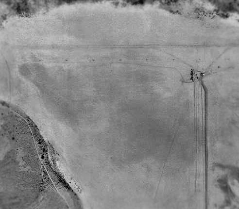
In the 1994 USGS aerial photo, the former airfield is in the southwest portion of the lakebed.
The long narrow shape extending across the north end of the lakebed is not a runway,
but the radio telescope array of the former Clark Lake Radio Observatory.
Only the slightest traces of the former runway on the south side of the lakebed were still perceptible.
Tim Tyler visited the Clark’s Dry Lake NOLF site in November 2004.
He reported: "The area is now used as a camp site for RVs & off-road recreational vehicles.
We couldn’t drive back to exactly where the old NOLF was
or the dirt field that later apparently supported the Clark Lake Radio Observatory,
but could pretty much see everything from where we were, and there wasn’t anything to see!
Other than the close to 50 campers spread around & plenty of ATVs,
the only thing we saw back there was an old rock crusher building at the base Coyote Mountain, at the W edge of the dry lakebed.
That probably explains the San Diego County DPW "Burnand Pit #611 – Unauthorized Removal of Material Prohibited" sign,
which along with "Not a Through Street," are the only signs posted
at the entrance off of County Road S22 / Borrego Salton Seaway Road.
The V-shaped notch of the mountains certainly would have made for a good aerial gunnery & bombardment range,
as well as a radio astronomy location (though obviously not concurrently)."

A 2006 aerial view by Joe Merkert looking north at the Clark's Dry Lake airfield site.
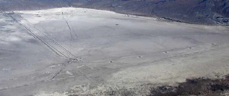
An October 2006 aerial view by Chip Sirek looking southwest at the Clark's Dry Lake airfield site.
Chip observed, “No RVs or campers, but we did fly somewhat lower and saw what we thought were tire marks on the runway.”
Woodrow Anselen reported in 2008, “Although desolate & arid beyond belief,
evidence abounds that something went on there quite some time ago.
With careful searching, detritus from a distant time can still be found on the lakebed.
I picked up several rusted metal hoops which I think might be 0.30 caliber ammunition links
such as were used to feed belt-fed weapons of this type.
Also I found a spent & much corroded bullet which also appears to be 0.30 caliber.
Most interesting, there are 2 peculiar structures on the lakebed whose purpose I cannot easily divine.
They appear to be (but surely are not) boat docks!
They are of concrete & rebar construction, and consist of a large thick concrete platform
supported some 10 feet off the ground by 4 concrete pillars.
On all 4 sides of the platform are rusted metal hooks.
The purpose of these remains a mystery.
The whole structure is badly deteriorated & may even be close to collapse.
Strangely, someone appears to have 'recently' ( in the desert, this is sometimes hard to tell)
supported one of the pillars with a substantial piece of timber.
Some thought & effort was put into this, as not only is the wood cut to fit securely, but also is bolted on.
I wonder why?”

A 6/4/09 photo by Woodrow Anselen of his Citabria at Clarks Dry Lake.
Woodrow observed, “Some of the mounds seem to change from the previous visits.
I can't imagine that this place gets all that much rain, but perhaps the water comes rushing down off the mountain with enough force to alter the landscape?”

A 6/4/09 photo by Woodrow Anselen of the concrete “rake” structure at the center of Clarks Dry Lake.
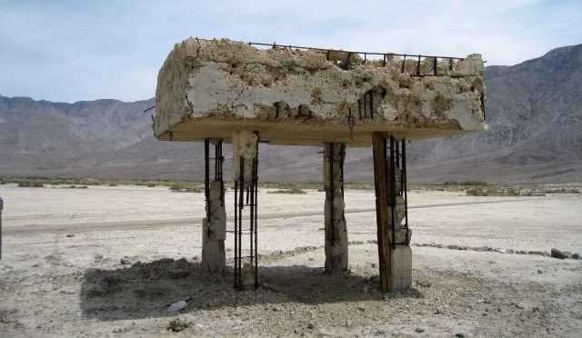
A 6/4/09 photo by Woodrow Anselen of concrete “rake” structure at the center of Clarks Dry Lake.
Bill Haneline reported in 2013, “There is some military aircraft wreckage on the dry lake.
There are a lot of 0.50 caliber shells & their clips to be found.
The University of Maryland gave the property to Anza-Borrego Desert State Park & nothing can be removed.
It would have been interesting to see the area before souvenir hunters took all the good stuff.”
The Clark's Dry Lake airfield site is located north of the intersection of Borrego Salton Sea Way & Rockhouse Trail,
eight miles northeast of Borrego Springs.
____________________________________________________
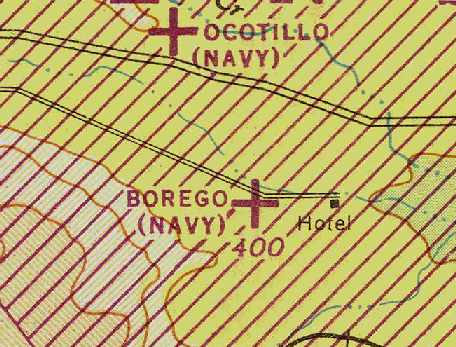
Borrego Hotel Naval Outlying Landing Field, Ocotillo Wells, CA
33.09, -116.1 (East-Northeast of San Diego, CA)
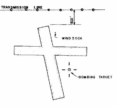
“Borego Hotel Emergency Landing Field / Field #06771”,
as depicted in a circa 1944 directory of NAS San Diego airfields (courtesy of Brian Rehwinkel).
Photo of the airfield while in use has not been located.
The date of establishment of the Borego Hotel airfield has not been determined.
The earliest depiction of the field which has been located
was on a June 1938 map of Leased Auxiliary Airfields for NAS San Diego (according to Brian Rehwinkel).
The Navy purchased 160 acres of land at the Borego Hotel Field from a private party in June 1941 for $2,830
(according to Navy documents at the National Archives, according to Brian Rehwinkel).
The field was to be used as an emergency landing field & dive bombing target
for the use of units based at San Diego NAS.
The airfield facilities consisted of a 2,600' north/south runway of unspecified construction,
and a 2,500' east/west dirt runway.
A bombing target with three concentric circles, 400' in overall diameter,
was situated to the southeast of the airfield.
No airfield at this location was depicted on the March 1944 San Diego Sectional Chart (according to Chris Kennedy).
However, a circa 1944 directory of NAS San Diego airfields (courtesy of Brian Rehwinkel)
depicted the “Borego Hotel Emergency Landing Field / Field #06771”
as having 2 sandy silt runways, 9/27 & 13/31, each 2,500' long.
A bombing target was depicted southeast of the runway intersection.
The field was said to be assigned for administrative & maintenance purposes to NAAS Salton Sea.
The earliest aeronautical chart depiction which has been located of the Borrego Hotel NOLF
was on the March 1945 San Diego Sectional Chart (courtesy of Chris Kennedy).
"Borrego (Navy)" was depicted on the March 1951 San Diego USAF Sectional Chart(according to Chris Kennedy),
but the Aerodromes table described the field as "Closed".

The 1953 San Diego-San Francisco Flight Chart (courtesy of Scott O'Donnell)
depicted the Borrego Hotel NOLF as having a 2,500' unpaved runway.
Borrego Hotel NOLF was still listed among active airfields on the "Aerodromes" table
on the 1955 San Diego Sectional Aeronautical Chart(courtesy of John Voss).
It described Borrego Hotel NOLF as having a 2,500 foot "All way" dry lake landing area.
However, that same year, the installation was declared excess by the Navy,
and the property was transferred to the General Services Administration for disposal.
The property was sold to a private party in 1956.
By the time of the October 1958 San Diego Sectional Chart (according to Chris Kennedy),
the Borrego Hotel airfield was no longer depicted at all.

No runway outlines or any other former airfield infrastructure
were perceptible in the 1994 USGS aerial photo of the site.
The former airfield on the dry lakebed was not depicted on recent USGS topo maps.
The former airfield property was still under private ownership as of 1997.
The airfield site is located on the dry lakebed of Halfhill Lake,
southeast of the intersection of Split Mountain Road & Old Kane Spring Road,
five miles southeast of Ocotillo Wells.
A 1997 Army Corps of Engineers report provides further details of Borrego Hotel NOLF.
____________________________________________________
Since this site was first put on the web in 1999, its popularity has grown tremendously.
That has caused it to often exceed bandwidth limitations
set by the company which I pay to host it on the web.
If the total quantity of material on this site is to continue to grow,
it will require ever-increasing funding to pay its expenses.
Therefore, I request financial contributions from site visitors,
to help defray the increasing costs of the site
and ensure that it continues to be available & to grow.
What would you pay for a good aviation magazine, or a good aviation book?
Please consider a donation of an equivalent amount, at the least.
This site is not supported by commercial advertising –
it is purely supported by donations.
If you enjoy the site, and would like to make a financial contribution,
you
may use a credit card via
![]() ,
using one of 2 methods:
,
using one of 2 methods:
To make a one-time donation of an amount of your choice:
Or you can sign up for a $10 monthly subscription to help support the site on an ongoing basis:
Or if you prefer to contact me directly concerning a contribution (for a mailing address to send a check),
please contact me at: paulandterryfreeman@gmail.com
If you enjoy this web site, please support it with a financial contribution.
This site covers airfields in all 50 states.