
Abandoned & Little-Known Airfields:
Eastern Kentucky
© 2003, © 2016 by Paul Freeman. Revised 3/27/16.
This site covers airfields in all 50 states: Click here for the site's main menu.
____________________________________________________
Please consider a financial contribution to support the continued growth & operation of this site.
Codell Field / Histle Field (revised 3/27/16) - Creech AAF (revised 7/25/15) - Hazard Airport (revised 3/2/16) - Irvine Airfield (added 9/20/15)
(Original) Marshall Field (added 8/16/15) - Morehead Rowan County Airport (revised 8/12/15) - Olive Hill Airport / Sellers Field (added 1/21/14)
Thorn Hill Airfield (revised 1/3/15) - Whitesburg Municipal Airport (revised 1/3/15) - Williamsburg Cumberland Falls Airport (revised 1/3/15)
____________________________________________________
37.72, -84 (East of Lexington, KY)
Irvine Airfield was labeled as a “Landing Strip” on the 1978 USGS topo map.
Photo of the airfield while in use has not been located.
Not much is known about this presumed private airfield, including its name or purpose.
The Irvine Airfield was evidently established at some point between 1966-78,
as it was not yet depicted on the 1960 USGS topo map
nor on the January 1966 Nashville Sectional Chart (courtesy of David Stevenson).
The earliest depiction which has been located of Irvine Airfield was on the 1978 USGS topo map,
which depicted a single northwest/southeast runway labeled simply as “Landing Strip”.

The 1982 USGS topo map continued to depict Irvine as a single northwest/southeast runway labeled simply as “Landing Strip”.

The earliest photo which has been located of Irvine Airfield was a 1995 USGS aerial view looking east.
It depicted Irvine as having a single paved Runway 14/28, with a ramp & hangar on the north end.

The last photo which has been located showing Irvine Airfield remaining intact was a 2013 aerial view looking east.
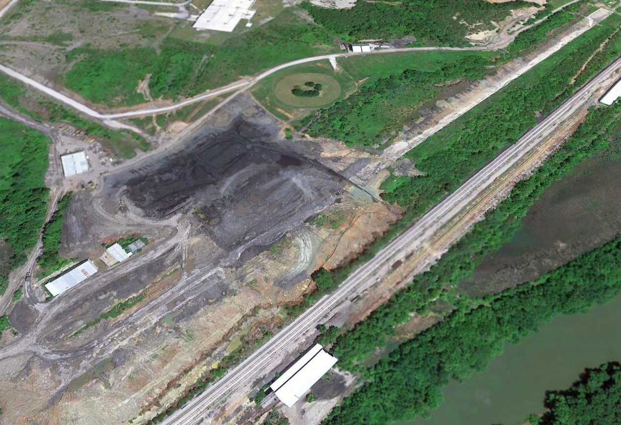
A 2014 aerial view looking east showed Irvine Airfield considerably deteriorated in only a year.
Eric Karnes observed that “the western end is being eaten up by a coal strip mine (an industry that is the bane of Kentucky's economy & environment).”
The 2015 Sectional Chart depicted Irvine as an abandoned airfield.
The site of Irvine Airfield is located at the western terminus of Route 1840.
Thanks to Eric Karnes for pointing out this airfield.
____________________________________________________
Codell Field / Histle Field, Winchester, KY
38.02, -84.22 (East of Lexington, KY)
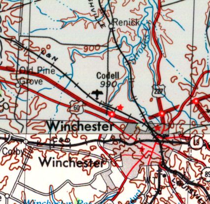
Codell Field, as depicted on the 1956 USGS topo map.
Photo of the airfield while in use has not been located.
The date of establishment of this small airfield has not been determined.
The earliest depiction which has been located of Codell Field was on the 1956 USGS topo map,

The 1965 USGS topo map depicted Codell Field as a single southeast/northwest runway, labeled simply as “Airstrip”,
with 1 small building on the south side.
The only aeronautical chart depiction which has been located of Codell Field
was on the January 1966 Nashville Sectional Chart (courtesy of David Stevenson).
It depicted Coddell as a private field having a 3,000' paved runway.
The earliest photo which has been located of Codell Field was a 1997 USGS aerial view looking northeast.
It depicted Codell as having a single paved runway, which was deteriorated & had closed-runway “X” symbols at each end.
A single hangar was located south of the runway.
A series of smaller buildings adjacent to the southeast side of the runway were presumably farm-related & not airfield-related.

A 2014 aerial view looking northeast showed the Codell Field paved runway & hangar remained intact.
According to Jacob McHone, this airfield may also have been known as Histle Field.
Jacob reported in 2015, “Histle Field in western Winchester just north of Interstate 64...
Hangars are still there but last time I was there the drive is now a private drive & the airfield is now a farm.
The hangars are used as stalls; the runway looks in good shape still.
I assume the owner of Histle Field sold the land & moved to Mt. Sterling because there is a strip south of KIOB listed as Histle Field on the Cincinnati Sectional Chart.”
The site of Codell Field is located northwest of the intersection of Van Metre Drive & Rockwell Drive.
Thanks to Jacob McHone for pointing out this airfield.
____________________________________________________
(Original) Marshall Field, Georgetown, KY
38.19 North / 84.57 West (Northwest of Lexington, KY)
The original Marshall Field, as depicted on a 3/1/52 USGS aerial photo.
The original airport for the town of Georgetown was located on the south side of town.
The original Marshall Field was evidently established at some point between 1945-52,
as it was not yet listed among active airfields in the 1945 AAF Airport Directory (courtesy of Scott Murdock).
The earliest depiction which has been located of Olive Hill Airport was a 3/1/52 USGS aerial photo,
which depicted a very well-defined northeast/southwest grass runway, with a parking area & airport circle marking on the south side side.
There were no hangars on aircraft visible on the field.
There was also a drive-in movie theater directly adjacent to the south side of the runway,
probably a little too close for comfort.
Eric Karnes recalled, “The original Marshall Field... was a short but busy little airport.
I remember the runway (about 1,800') running perpendicular to US-25.”

The 1954 USGS topo map depicted Marshall Field as having an unpaved northeast/southwest runway, with a drive-in theater adjacent to the south side.
A 1959 aerial view showed Marshall Field to be much busier,
with a total of 16 light single-engine aircraft on the parking area on the south side of the runway.

A 2/15/65 USGS aerial photo view of Marshall Field showed a dramatically different scene compared to the 1952 photo,
with a total of 22 light single-engine aircraft completely filling the available parking area on the south side of the runway.

The last topo map depiction which has been located of the original Marshall Field was on the 1993 USGS topo map.
Eric Karnes recalled, “The original Marshall Field... was replaced by a much larger Georgetown-Scott County Airport east of town.”
Georgetown-Scott County Airport opened in 1993, at which point the original Marshall Field was closed.
A 1994 aerial view showed the original Marshall Field remained intact, but devoid of any aircraft.
A 1997 aerial view showed several baseball diamonds had been constructed over the site of the original Marshall Field.

A 2014 aerial view of the site of the original Marshall Field shows the property reused as Marshall Park,
but the alignment of the former runway is still recognizable.
Eric Karnes reported in 2015, “The original Marshall Field... Today it's Marshall Park, on Airport Road at US-25.”
The site of the original Marshall Field is located at the western terminus of Airport Road, appropriately enough.
Thanks to Eric Karnes for pointing out this airfield.
____________________________________________________
Olive Hill Airport / Sellers Field (2I2), Olive Hill, KY
38.25 North / 83.14 West (Northeast of Lexington, KY)

Olive Hill Airport, as depicted on a 3/29/61 USGS aerial photo.
According to its FAA Airport/Facility Directory data (courtesy of Richard Finley), Olive Hill Airport was activated on 11/1/60.
The earliest depiction which has been located of Olive Hill Airport was on a 3/29/61 USGS aerial photo,
which depicted it as having an unpaved northeast/southwest runway, with a hangar along the west side.

The 1962 USGS topo map depicted Olive Hill Airport as having an unpaved northeast/southwest runway, with a hangar along the west side.

A 7/2/69 USGS aerial photo appeared to depict Olive Hill Airport with a newly-built paved ruway,
onto which one aircraft appeared to be entering at mid-field.
The airport was renamed Sellers Field in 1974 to honor Matthew Sellers,
an aviation pioneer & the first person to fly an airplane in Kentucky.

The July 1999 Cincinnati Sectional Chart (courtesy of Richard Finley) depicted Olive Hill Sellers as having a 2,500' runway.

A 12/12/07 aerial view looking southwest showed Olive Hill's runway still marked as an active runway.
According to a city status document (courtesy of Richard Finley),
the town of Olive Hill suffered from severe flooding in May 2010, which put a great economic stress on the community.
Olive Hill Airport had a 2,900' runway, parking ramp and fueling facilities.
It serviced the construction industry, Carter Cave State Park visitors, business people and others.
But due to issues over lack of maintenance, the state closed it in early 2010.
A 6/20/10 aerial photo showed Olive Hill's runway marked with closed-runway “X” symbols.
According to its FAA Airport/Facility Directory data (courtesy of Richard Finley),
for a 12-month period ending 9/27/10 Olive Hill Airport conducted 50 takeoffs or landings & had 3 single-engine aircraft based at the airport.
Olive Hill Airport consisted of 31 acres, with a 2,500' asphalt Runway 2/20.
An article entitled “Olive Hill Council Votes To Keep Airport” by Keith Kappes in the 7/25/12 Publisher Journal-Times (courtesy of Richard Finley)
reported that “a few months ago, Council declared the airport to be surplus property & ordered that it be sold.”
However, “Mayor Danny Sparks, who originally had recommended the sale, said Tuesday that he was wrong about the airport’s value to the city.
He then asked the Council members to reverse their earlier decision. They did so, 5-0.
The mayor said the 24-acre facility, no longer certified as an airport, can become a valuable tourism asset to the city as shown by the recent Heritage Trail Festival.”
State Sen. Robin Webb described the property as a “jewel” that the city should retain.
An article entitled “Olive Hill City Council Votes To Close Pool, Airport” by Joe Lewis in the 3/27/13 Journal-Times (courtesy of Richard Finley)
said, “Council also voted unanimously to empower the mayor to sign a document removing the old city airport from all piloting & FAA maps,
effectively closing the facility to further air traffic.”

A 10/8/13 aerial view looking southwest showed Olive Hill's runway marked with closed-runway “X” symbols,
but the airport otherwise remained intact.
Olive Hill Airport is located southeast of the intersection of Ben's Run Road & Airport Drive.
Thanks to Richard Finley for pointing out this airfield.
____________________________________________________
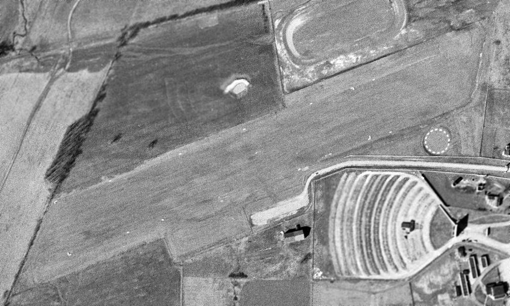
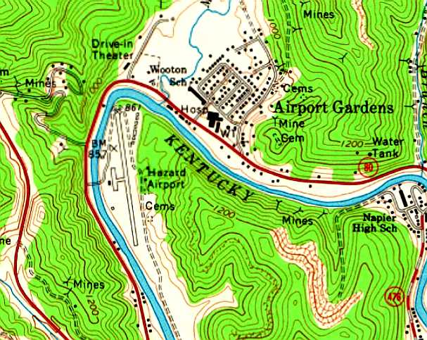
37.28, -83.21 (Southeast of Lexington, KY)

Hazard Airport, as depicted on the 1954 USGS topo map.
According to the Sunday Herald-Leader (courtesy of Mark Hess),
Hazard Airport was established sometime on or before 1947.
However, Hazard Airport was not yet depicted on the 1949 USGS topo map.
The earliest depiction which has been located of Hazard Airport was on the 1954 USGS topo map,
which depicted it as a northwest/southeast clearing along the east bank of the Kentucky River.
Allen McDavitt recalled, “The Hazard Airport was in Hazard, KY,
the same Hazard fictionally represented on the Dukes of Hazard TV show.
This airport was down in a deep valley surrounded by some good-sized mountains.
My ex-father-in-law owned a home close to the top of one of the overlooking mountains.
I remember many times sitting on the deck watching the airplanes flying up & down the valley below on their way to or from the airport.”
Jim recalled, “The old Hazard Airport... I learned to fly there & was in the Civil Air Patrol.
This was right upn to the 1957 flood, which wiped out most of our airplanes.”
Taoist recalled, “I lived in Hazard from 1958-62.
My mother was a laboratory technician in the old Miners Memorial Hospital during that time.
There was a doctor at the hospital that was my hero & he used to fly for pleasure out of the Hazard Airport.
His name was Dr. Bill Leonard, and he had a old Stinson Voyager & we would go up every couple of months.
On a few occasions he even let me fly the Stinson as well as a Piper J2 Cub that he used to fly occasionally.
I don't think the Piper was his but belonged to a flying club at the airport.
We got to the airport by parking his car next to Highway 15 & walking across a swinging bridge over the river.
The airport runway was completely grass with very few buildings on site.
The airplanes were always lined up with their tails towards the river.”

The 1968 Flight Guide (courtesy of Robert Levittan) depicted Hazard Airport
as having a single 2,300' paved Runway 17/35, with a few small buildings on the west & east sides.
Divadawg recalled, “I can remember landing at the old Hazard Airport in the summer of 1968.
Several members of Hazard's yearbook staff had gone to Athens, Ohio, for training & we had to fly home because of problems with land transportation.
That was the first & last flight I ever made into that airport & boy was it exciting!
I can remember thinking, 'I sure hope the brakes on this plane work cause if they don't we are all going to be in a world of hurt!'
Fortunately, all went well, but it sure took a person with nerves of steel to fly into or out of that airport!”

The earliest photo which has been located of the Hazard Airport was a 4/10/71 USGS aerial photo.
It depicted Hazard as having a single paved northwest/southeast runway.
A ramp with a few small buildings & 2 light planes was on the west side,
and a cluster of small hangars was on the northeast side.
The 1972 USGS topo map depicted Hazard Airport
as having a single paved northwest/southeast runway.
A ramp with a small buildings was on the west side,
and a cluster of small hangars was on the northeast side.

An undated (circa 1970s?) aerial view looking east at Hazard Airport (courtesy of James Henz)
showed a single paved runway, with taxiways leading to a ramp with several buildings & 8 single-engine aircraft.

An undated (circa 1970s?) aerial view looking south at Hazard Airport (courtesy of Rick Harshbarger)
showed what appeared to be several light aircraft on the ramp.
Roger Dearnaley recalled, “When I was in high school in the 1970s, I worked at Kentucky Flying Service at Bowman Field.
The charter pilots often had to fly to Hazard, and told many stories about close calls there.
The was before the TV show, but the thought that the name Hazard was appropriate since it was quite 'hazardous'.”

The last photo which has been located of the Hazard Airport was a 3/4/77 USGS aerial photo.
The 1979 USGS topo map still depicted the Hazard Airport.
Tim recalled, “I remember the day Tom Wopat of The Dukes of Hazard landed there.
It was a huge deal for the town. Hundreds came to see him. You'd think that Elvis was in town.”
Spanky recalled, “I remember going to the old airport with my grandfather. We'd sit there for hours.”
Mikey Bowling recalled, “I used to hang out there a lot with my dad.
He had a couple of business planes there for his company.
Alice Noble would take me in some of the planes & taxi me down the runway.
I also remember watching Jim Brewer do all sorts of trick in his plane. I loved that place.”
According to the 1/10/82 Sunday Herald-Leader (courtesy of Mark Hess),
actor Tom Wopat of television's “The Dukes of Hazard” flew into Hazard Airport to present a check to a local charity.
Hazard Airport was evidently closed at some point between 1982-92,
as the 1992 USGS topo map labeled the southern portion of the airport site as Gorman Park,
and depicted the Perry County Central High School on the northern portion.
Allen McDavitt recalled, “About the best remaining evidence is a subdivision known as Airport Gardens
on the other side of the North Fork of the Kentucky River from the airport site.”

A 6/20/10 aerial photo did not show any remaining trace of Hazard Airport.
The site of Hazard Airport is located northeast of the intersection of Park Avenue & Perry Park Road.
Thanks to Allen McDavitt for pointing out this airfield.
____________________________________________________
Williamsburg Cumberland Falls Airport (4I1), Williamsburg, KY
36.83 North / 84.19 West (South of Lexington, KY)

The Williamsburg Cumberland Falls Airport, as depicted on the 1965 USGS topo map.
Williamsburg Cumberland Falls Airport was evidently established at some point between 1952-65,
as it was not yet depicted on the 1952 USGS topo map.
The earliest depiction which has been located of the Williamsburg Cumberland Falls Airport was on the 1965 USGS topo map.

The 1969 USGS topo map depicted the Williamsburg Cumberland Falls Airport
as having a single unpaved northeast/southwest runway.

The earliest photo which has been located of the Williamsburg Cumberland Falls Airport was a 5/27/69 USGS aerial view.
It depicted the field as having a single unpaved northeast/southwest runway.

The 1982 USGS topo map depicted the Williamsburg Cumberland Falls Airport
as having a single unpaved northeast/southwest runway.
A single small building had evidently been added on the southwest side at some point between 1969-82.

Williamsburg Cumberland Falls Airport had evidently gained a paved runway at some point between 1982-97,
as a 1997 USGS aerial view depicted the field as having a single paved Runway 6/24, with a single small hangar on the southwest side.
There were no planes visible on the field.

A June 2004 aerial view looking northeast at the Williamsburg Cumberland Falls Airport.
In March 2005 a larger Williamsburg-Whitley County Airport was built to the southwest,
and the Williamsburg Cumberland Falls Airport was presumably closed at the same time.
As of 2009 the Williamsburg Cumberland Falls Airport was no longer depicted on aeronautical charts.
The site of the Williamsburg Cumberland Falls Airport is located northeast of the intersection of Pilot Drive & Airport Road, appropriately enough.
Thanks to Aaron Renfro for pointing out this airfield.
____________________________________________________
Morehead Rowan County Airport, Farmers, KY
38.13 North / 83.54 West (East of Lexington, KY)

Morehead Rowan County Airport, as depicted on the February 1964 Huntington Sectional Chart (courtesy of Chris Kennedy).
Morehead Rowan County Airport was evidently established at some point between 1953-64,
as it was not yet depicted on the 1953 USGS topo map,
nor on the January 1963 Huntington Sectional Chart (according to Chris Kennedy).
The earliest depiction which has been located of the Morehead Rowan County Airport
was on the February 1964 Huntington Sectional Chart (courtesy of Chris Kennedy).
It depicted the field as having a 3,000' unpaved runway.
The Rowan County Airport evidently gained a paved runway within the next year,
as the August 1965 Huntington Sectional Chart ( courtesy of Chris Kennedy)
depicted the field as having a single 2,600' paved runway.

The 1968 Flight Guide (courtesy of Robert Levittan) depicted Morehead Rowan County Airport
as having a single paved 2,600' Runway 5/23, with a ramp & 2 small buildings on the north side.

The 1970 USGS topo map depicted the Morehead Rowan County Airport
as having a single paved northeast/southwest runway,
with a ramp with a single hangar on the north side.

The 1983 USGS topo map depicted the Morehead Rowan County Airport
as having a single paved northeast/southwest runway,
with a ramp with a single hangar on the north side.

A 6/19/04 aerial photo showed Rowan County to have 4 single-engine planes parked on the ramp,
around which were several small hangars.
Note another T-hangar next to the filtration plant adjacent to the southwest side of the airport.

A circa 2006 aerial view looking west showed 3 single-engine planes parked on the ramp,
around which were several small hangars.
In July 2007 the new Morehead-Rowan County Clyde A. Thomas Regional Airport opened to the north,
at which point the original Morehead-Rowan County Airport presumably was closed.

The Rowan County Airport was closed by 2008,
as a 2008 photo by Nicki Sloan-Petronella showed large closed-runway “X” symbols painted over the runway.

A 2008 photo by Nicki Sloan-Petronella looking west at the ramp,
showing the former office & one hangar (the other hangars have presumably been removed).
Nicki noted, “Notice the hangar is full of hay, now!
I wish I could have gotten closer, but there is a gate blocking the drive. Makes me so sad!
The is the runway where I had my first airplane ride as a child and later, my first lesson.
The runway is nestled in the hills so that when you are at lower altitudes, especially when using Runway 23, it actually disappears behind the hills!”
The site of the Rowan County Airport is located southwest of the intersection of C Thompson Road & Airport Road, appropriately enough.
____________________________________________________
Whitesburg Municipal Airport, Whitesburg, KY
37.23 North / 82.87 West (Northeast of Knoxville, TN)

The Whitesburg Airport, as depicted on the March 1966 Winston-Salem Sectional Chart (courtesy of Chris Kennedy).
Photo of the airfield while open has not been located.
According to Mark Collins, this small general aviation airport also may have been known as Isom Airport.
Whitesburg Airport was evidently established at some point between 1964-66,
as it was not yet depicted on the April 1964 Winston-Salem Sectional Chart (according to Chris Kennedy).
The earliest depiction which has been located of the Whitesburg Airport
was on the March 1966 Winston-Salem Sectional Chart (courtesy of Chris Kennedy).
It depicted Whitesburg as having a single 2,500' paved north/south runway,
along with a VOR navigational beacon.
James Wright recalled, “The Whitesburg Airport was built on the leveled-off top of a hill which had been strip-mined for coal.
As a just-licensed VFR pilot on a long cross country flight in a Cessna 150, I was caught in a snowstorm on 12/23/70,
and landed there to escape lowering conditions & high winds. At that time, it was operational, but unattended.
Fortunately for me, the Letcher County sheriff (with the unforgettable name of Maynard Hogg) was a pilot with a plane there,
and had heard me circling, so he drove up the steep road in a 4-wheel drive vehicle & took me into Whitesburg to a hotel.
The next morning, he delivered me back to my plane. I will always remember his kindness.”

The last aeronautical chart depiction which has been located of the Whitesburg Airport
was on the August 1976 Cincinnati Sectional Chart (courtesy of Chris Kennedy).
It depicted Whitesburg as having a single 2,500' paved north/south runway.
The adjacent Whitesburg VOR navigation beacon had been upgraded
at some point between 1966-66 to a VORTAC (combination VOR & TACAN beacon).

The 1978 USGS topo map depicted “Whitesburg Municipal Airport” as having a single paved runway.

The 1992 USGS topo map depicted “Whitesburg Municipal Airport” as having a single paved runway
with a paved ramp & a single small building on the west side of the field.

As seen in a 1995 USGS aerial view looking southeast, the runway at the former Whitesburg Airport
was still marked as an active runway (without any closed-runway symbols).
The former building on the ramp on the west side of the field appeared to have been removed.
What appears to have been the building housing the former Whitesburg VORTAC navigational beacon
remained in the clearing on the east side of the strip.
According to a report for the Letcher County Public Libraries,
the Whitesburg Airport was closed at some point between 1960-2000.
Neither the Whitesburg Airport nor the Whitesburg VORTAC
were depicted at all on the December 2003 Cincinnati Sectional Chart (according to Chris Kennedy).
Mark Collins reported in 2005, “The landing strip is still there but is in rough shape.
It is only accessible with all-terrain vehicles or 4-wheel drive trucks.”

An October 2006 photo by Mark Collins of the abandoned runway at the site of the Whitesburg Airport.

An October 2006 photo by Mark Collins of the building which remains standing at the site of the Whitesburg Airport.
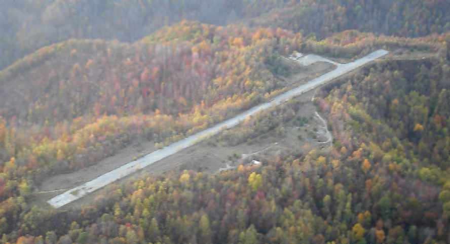
A 2007 photo by Brian Thompson looking northwest from a Cessna 180 at the Whitesburg Airport.
Brian reported, “The picture was shot at 1,500' AGL above the old airstrip & shows the fall foliage on this beautiful Kentucky afternoon.”

A circa 2006-2010 aerial view looking north at the remains of Whitesburg Airport.

A 6/21/10 aerial view looking southeast showed that Whitesburg's Runway 17 markings were still barely recognizable.
The site of the Whitesburg Airport is located at the southern terminus of Route 2547.
____________________________________________________
Thorn Hill Airfield, Kenton, KY
38.86 North / 84.45 West (South of Cincinnati, OH)

A 4/19/60 USGS aerial photo appeared to show the Thorn Hill Airfield when it was newly constructed.
According to drag racing historian Bret Kepner, this airfield had a colorful history.
Through information from locals & the track's employees during a visit around 1985,
he learned that "the airfield was built by alcohol bootleggers during Prohibition.
The airstrip was created deep in the woods where it was virtually undetectable from the ground.
The moonshine, brewed in the nearby Kentucky hills,
was smuggled on night flights to nearby Cincinnati, OH.
Near the end of Prohibition, the operations at the Kenton airstrip were sacked by Treasury agents,
resulting in a large number of arrests.
The Feds eventually bequeathed the seized land to the town of Kenton,
whose mayor apparently assisted in the bust.
However 1949 & 1952 USGS aerial photos just showed a farm field, with no recognizable sign of an airfield.
And no airfield was depicted at the site on the 1953 USGS topo map.
According to drag racing historian Bret Kepner, “The airstrip sat, unused, until the hot rodding craze of the 1950s
resulted in the local arrest of a young street racer...the mayor's son!
The mayor agreed to allow the kid to turn the abandoned airfield into a drag strip
if it would keep his son's racing activities off the street.
Thus was born Thorn Hill Drag Strip!"
The earliest photo which has been located of the Thorn Hill Airfield was a 4/19/60 USGS aerial photo.
It appeared to show the Thorn Hill Airfield when it was newly constructed,
with a single northeast/southwest runway.
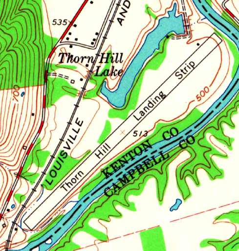
“Thorn Hill Landing Strip”, as depicted on the 1961 USGS topo map.
It was not listed among active civil airfields in the 1962 AOPA Airport Directory.
According to Steve Trutschel, “Ralf Payne owned & operated that property until his passing in the mid-1990s.
I used to fly my Cub in there all the time & if they were racing I would enter the pattern
and the guy lining up the cars at the starting line would hold them in place & motion me to land.
I flew in & watched the races many Saturday evenings as Thornhill is only about 5 miles from the private airstrip where I live.
I also flew ultralights into there years before I owned my Cub.”
Steve continued, “My father raced there when he was a kid in the mid-1950s
and it was a dirt drag strip when he started racing there.
Everyone would use snow tires for traction.
He remembers how great it was the day Ralf blacktopped the first 100 or 150 feet of the strip for traction for them.
When I was a kid in the mid-1960s there were at least 3 airplanes kept there.
I ended up buying a worn-out 1946 Stinson 108-3, that ironically, was one of the 3 planes that used to be kept there.
It is still very much country out there & I know of no ordinances that would prevent aircraft operations there.
Our nickname for the dragstrip was, and still is, Ralf's Palace.”
Steve continued, “Over the years I would have several friends fly into the dragstrip
and I would pick them up because my strip is very short & a Cub is one of the few planes that can go in there.
One day I met a couple of friends at the dragstrip & they were flying a completely restored Beech T-34,
complete with all the Navy military markings.
Ralf ALWAYS drove out & met you at the plane.
I assume it was Ralfs wife with him as he met the T-34.
My buddy slid the canopy back, stood up in the seat, looked around & said,
"I don't know, this doesn't look like Kansas to me!"
Ralfs wife stood there looking at the military plane in total disbelief
and said, "Oh my God, you guys are no where near Kansas!"”
Steve continued, “I quit flying the Cub in there because I tore it down to restore it.
Sadly Ralf passed away before it was finished & he never got to see it again.
I know several people that still race there every Saturday in the summer.
In this day & age there are more & more houses being built, and more & more complainers.
Most of the complainers are on the other side of the river & that is a different county so it is complicated.
But I enjoy the races & I can hear them at my house, It's just part of that area.
I know several people that race there & one of them has even asked the new owner if I could fly in there again.
His response to them was, "As long as I get an airplane ride." We'll see.”
The earliest depiction which has been located of the Thorn Hill Airfield was on the 1961 USGS topo map.
It depicted “Thorn Hill Landing Strip” as a single northeast/southwest runway,
with a small building on the north side.
Thorn Hill was not listed among active civil airfields in the 1982 AOPA Airport Directory.
The 1983 USGS topo map depicted the single former runway but did not label it at all.
The former runway was labeled "drag strip" on the 1984 USGS topo map.

As seen in the 1993 USGS aerial photo, the former airfield consists of a single 3,100' runway.
The property was also used until 2001 for flying radio controlled model aircraft,
until that use was also precluded by zoning.
It was labeled "drag strip" on the 2002 Sectional Aeronautical Chart.
According to Jim Decker, the current property owner said zoning is causing problems with the drag strip,
and precludes him from renting tie downs for aircraft.
The 7/9/01 issue of the Cincinnati Enquirer reported
that neighbors had been making complaints about the noise from drag racing at Thorn Hill.

A circa 2006-2010 aerial view looking west at the north end of the former Thorn Hill runway,
now reused as a drag strip.

An 8/30/12 aerial view looking southwest along the former Thorn Hill runway.

An 11/14/12 aerial view by Paul Freeman looking northeast at the former Thorn Hill runway.
The Thorn Hill Airfield is located along the west bank of the Licking River,
a half mile southeast of the town of Kenton.
____________________________________________________
Creech Army Airfield, Arkansas City, KY
38.08 North / 84.32 West (East of Lexington, KY)

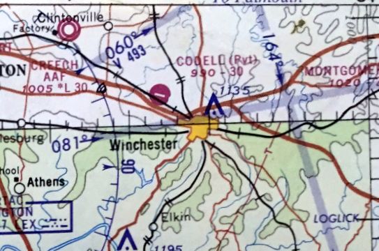
Creech AAF, as depicted in the 1960 Jeppesen Airway Manual (courtesy of Chris Kennedy).
According to an Army Corps of Engineers report, the Lexington Signal Depot
was built early in WW2 to store, repair & issue the Signal Corps' communications & electronic equipment.
According to the 11/20/58 Lexington Herald (courtesy of Mark Hess), Creech Army Airfield was dedicated on 11/19/58.
The airfield was built to support the activities of the Lexington Blue Grass Army Depot.
The earliest depiction of Creech Army Airfield which has been located
was in the 1960 Jeppesen Airway Manual (courtesy of Chris Kennedy).
It depicted the field as having a single 2,000' Runway 11/29,
with a taxiway leading to the southwest to a ramp with an operations building & several other buildings.
A control tower was depicted south of the runway.
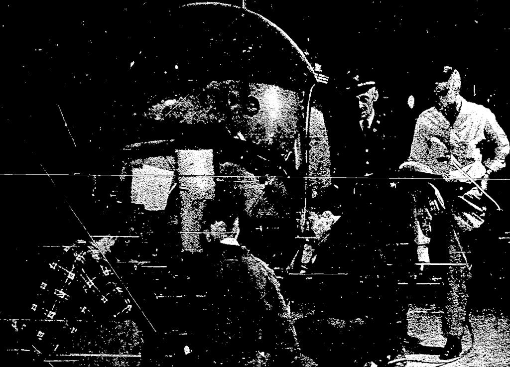
A January 1960 photo (courtesy of Mark Hess) of a Bell H-13 helicopter being refitted with new UHF & FM radio equipment by a Lexington Signal Depot avionics crew.

A March 1960 photo (courtesy of Mark Hess) of the Lexington Signal Depot's L-20 aircraft.
Creech AAF was described as having a 2,000' steel pierced planking runway & a control tower.

An 11/9/60 USGS aerial photo showed Creech AAF to have a single paved Runway 12/21,
with a taxiway connecting the runway to a ramp with two small hangars.
A control tower was south of the runway.
A total of 4 light fixed-wing aircraft were parked on the ramp.
77777777777777

The 1961 Cincinnati Sectional Chart (courtesy of Chris Kennedy)
described Creech AAF as having a single 3,000' pierced steel planking runway.

The 1965 USGS topo map depicted Lexington Blue Grass Army Depot as having an airfield with a single paved northwest/southeast runway,
a tower, and a taxiway leading to a ramp with 3 buildings on the southwest side.
The January 1966 Nashville Sectional Chart (courtesy of David Stevenson)
depicted Creech AAF as having a 3,000' paved runway.
The 1968 Cincinnati Sectional Chart (according to Chris Kennedy)
described Creech AAF as having a single 3,000' pierced steel planking runway.

Creech AAF, as depicted on the 1970 Cincinnati Sectional Chart (courtesy of Chris Kennedy).
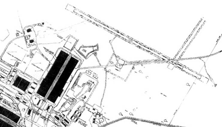
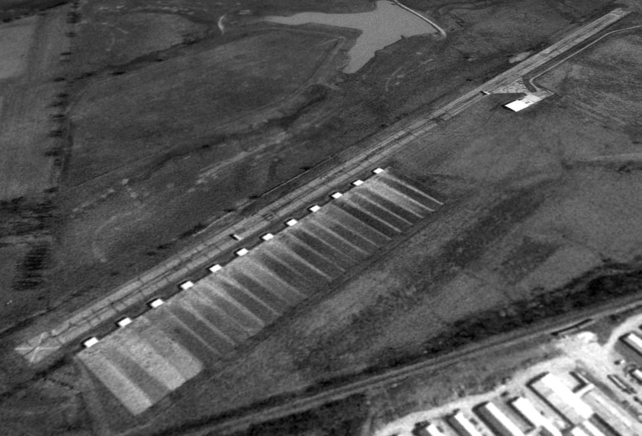
A 1974 Facility Layout Plan of the Lexington Blue Grass Army Depot,
depicting the existing runway & the (apparently planned but never built) crosswind runway.
William Kempf recalled that in 1984 "I was stationed there & it had a nice set of runway lights & bumpy dirt runway."
He recalled that the runway would have been usable for small single engine fixed wing aircraft.
"But what I remember most was a large 75' high x 100' wide x 200' long hangar from at least the mid 1940's
that seems to be on the map but is missing from the photo?"
The Depot was placed on the Base Realignment & Closure list in 1991,
and was scheduled to be transferred to the Kentucky National Guard in 1994.
According to JSH, "The depot's main DOD contractor, Raytheon,
moved most of its operations to the Blue Grass Army Depot in Richmond
after the Lexington Blue Grass Army Depot's closing."

As seen in the 1993 USGS aerial photo,
the airfield consisted of a single 3,000' paved runway (which was crossed along its southeastern end by a road),
and a taxiway connecting the runway to a ramp with two small hangars.
There was no sign of the control tower depicted on the 1960 diagram.
East of the ramp was a helipad which was built at a later date than the runway,
as it did not appear in the above 1974 plan,
and it appeared to have been used up to a later date than the runway.
The date of closure of the Creech airfield is unknown,
but it was depicted as an abandoned airfield on the 1998 World Aeronautical Chart.

A circa 2002 photo by William Kempf of the odd-shaped building at Creech AAF,
with what appears to be a rear fuselage portion from an unidentified aircraft at left.
William reported, “They seem to be used sometime before 2002 for helicopter depot rebuilding.”
Bill North reported in 2003 that the "odd shaped buildings or Quonset huts…
that is where the first radar units were tested after their development.
Other than the metal outer skin, there is no metal in the building & the interior is all wood."
Bill reported of the buildings used for the first radar testing,
"There has been some talk as to placing them under some sort of historical preservation
but I am not sure the status of that effort."
A 2004 aerial photo showed dramatic changes since the 1993 photo,
with the runway pavement having been completely removed,
and a new hangar & helipad having been built just northeast of the odd-shaped buildings southwest of the runway.
A 2006 aerial view showed further changes since 2004,
with a second, larger hangar having been built over the site of the helipad,
and a replacement helipad having been constructed on the east side of the 2 hangars.
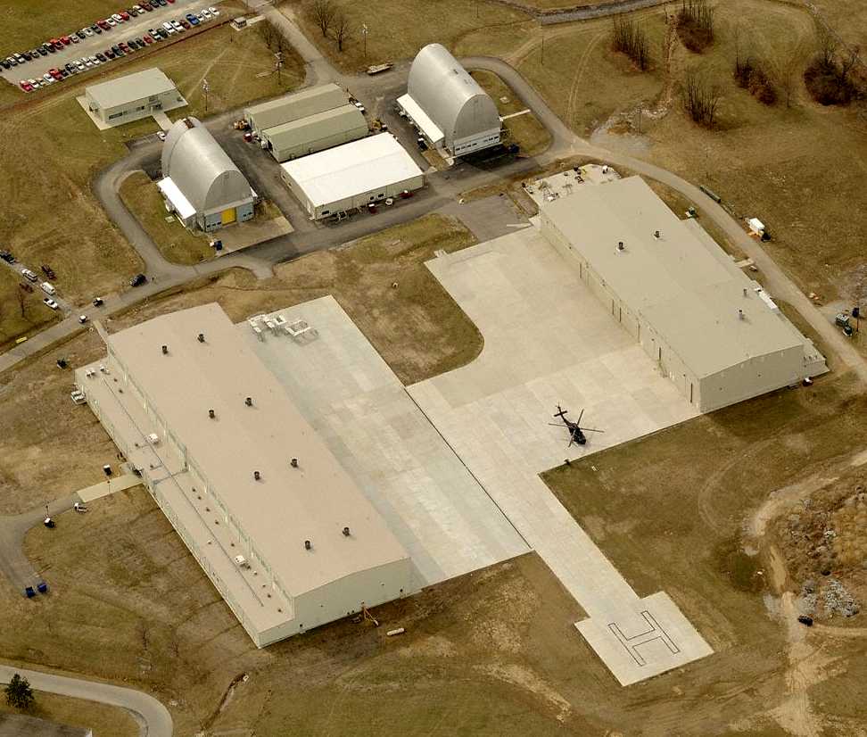
A circa 2006-2008 aerial view looking west showing the odd-shaped buildings at the top of the photo,
along with the recent-construction National Guard hangars & helipad, along with a sole UH-60 Blackhawk.
A 2008 aerial view showed 2 CH-47 Chinooks on the ramp,
and a new paved taxiway leading to 2 paved helipads located over the location of the west end of the former paved runway,
bringing the facility full-circle in a sense.
____________________________________________________
Since this site was first put on the web in 1999, its popularity has grown tremendously.
That has caused it to often exceed bandwidth limitations
set by the company which I pay to host it on the web.
If the total quantity of material on this site is to continue to grow,
it will require ever-increasing funding to pay its expenses.
Therefore, I request financial contributions from site visitors,
to help defray the increasing costs of the site
and ensure that it continues to be available & to grow.
What would you pay for a good aviation magazine, or a good aviation book?
Please consider a donation of an equivalent amount, at the least.
This site is not supported by commercial advertising –
it is purely supported by donations.
If you enjoy the site, and would like to make a financial contribution,
you
may use a credit card via
![]() ,
using one of 2 methods:
,
using one of 2 methods:
To make a one-time donation of an amount of your choice:
Or you can sign up for a $10 monthly subscription to help support the site on an ongoing basis:
Or if you prefer to contact me directly concerning a contribution (for a mailing address to send a check),
please contact me at: paulandterryfreeman@gmail.com
If you enjoy this web site, please support it with a financial contribution.
please contact me at: paulandterryfreeman@gmail.com
If you enjoy this web site, please support it with a financial contribution.
____________________________________________________
This site covers airfields in all 50 states.