Abandoned & Little-Known Airfields:
Massachusetts: Northern Boston area
© 2002, © 2016 by Paul Freeman. Revised 11/30/16.
This site covers airfields in all 50 states: Click here for the site's main menu.
____________________________________________________
Please consider a financial contribution to support the continued growth & operation of this site.
Billerica-Wilmington Airport (added 10/26/13) - Muller Field / Riverside Airport / Revere Airport (revised 6/29/15)
Robbins Airport (revised 9/25/16) - Salem CGAS (revised 9/21/16) - Saugus Field / Atwood Park (added 11/30/16)
____________________________________________________
Saugus Field / Atwood Park, Saugus, MA
42.44, -71.006 (North of Boston, MA)

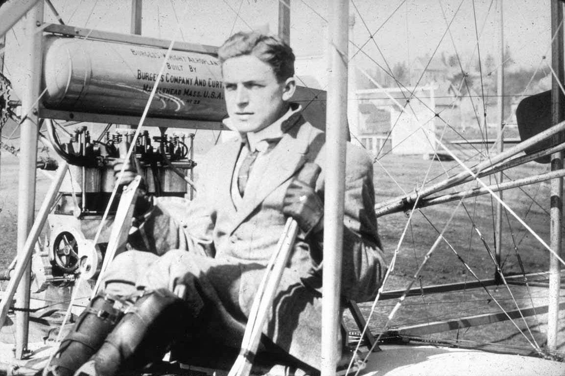
An undated photo of a pilot (Harry Atwood?) at Atwood Park (courtesy of Sandy Muise).
According to Wikipedia, a one-mile oval horse racing track named Franklin Park was operated at this location from 1859-1905.
“The idea of building an aviation field on the site of the Old Saugus Race Track was first proposed in December 1910 by the Aeroplane Company of America.
The company proposed spending $100,000 to convert the old race track into an airfield & construct a factory for the manufacturing of flying machines.
The company also planned to maintain a flight school & hold aviation meets on the site.
The company asked the town to extend its water mains to the field, improve its electrical light equipment,
keep the roads leading to the field in good condition, and be lenient in the tax assessment of the improved property.
The Saugus site was chosen because it consisted of many acres of flat, dry land & open marsh land,
there was sufficient room for the construction of new buildings, and the atmospheric conditions were ideal for flying.
Flying began at the Saugus race track in 1911.”
The Wikipedia article continued, “On 12/21/1911 Harry Atwood claimed to break the record for longest time in the air in a hydroaeroplane by remaining in the air for 80 minutes.
On 5/30/12-6/1/12 Atwood Park hosted an aviation meet that was attended by some of the biggest aviators in the country, including Atwood, Lincoln Beachey, Philip W. Page, and Arch Freeman.
On the first day of the meet, Atwood made the first airmail delivery in New England.
He flew about 5 miles to the Lynn, MA Town Commons where he dropped a sack of mail from the plane.
The sack was then retrieved by a Lynn postal employee & driven to the Post Office.
On 7/31/1912 'Boy Aviator' Farnum Fish & a student survived a crash after a plane they were flying hit an air pocket,
dropped 150 feet, crashed into a pole, turned upside-down, and fell to the ground.
Fish was able to extract himself from the plane, but then fell headlong into a ditch filled with water.
Morris Shoemanhorne, Fish's student, was also able to remove himself from the wreck.
The two were then assisted by mechanics who had been working in the hangar.
Fish suffered only minor injuries while Shoemanhorne had a bruised head & a badly twisted right ankle.
Shoemanhorne's injuries were attended to at the Race Track Hotel & then he was sent home.”
The Wikipedia article continued, “In 1912, the property was purchased by the General Aviation Corporation who named it Atwood Park in honor of pilot Harry Atwood.
Atwood Park was home to one of the busiest aviation schools in the country.
In 1912 the school had 43 students, more than any other aviation school in the U.S.
The school used a Burgess–Wright Model B for instruction.
Atwood was the school's chief instructor, but assistant instructor Arch Freeman did most of the flying.
Ripley Bowman also instructed at the school. Atwood quit on 6/10/12.
The reasons given for his departure were that he could make more money in exhibition flights & he had become disenchanted with Freeman.
Atwood took the school's only plane with him & as a result, the school closed.
None of the students had completed their formal training, but some students, including Jack McGee, Roy Waite, and Ruth Bancroft Law,
had received enough training that they were able to fly their own planes solo.
Waite established a new school at the aviation field that remained open until early 1913.
After Atwood's departure the airfield was known as the Saugus Field, Whittemore-Hamm Aviation Field,
Franklin Park Aviation Field, or the Saugus Race Track, in reference to the property's former use.”
The Wikipedia article continued, “On 10/21/1915, Chauncy Redding & Philip Bulman were killed when their plane crashed about a third of a mile from the airfield.
The plane dropped 800 feet after the supporting braces & wires holding one of the wings suddenly collapsed.”
The 1918 USGS topo map depicted the oval racetrack, but did not label the property as an airfield.
According to Wikipedia, “On 5/16/1919, Melvin Hodgdon won the Boston Globe Trophy by flying from Atlantic City, NJ to Saugus in 3 hours & 59 minutes.”
The 1925 USGS topo map continued to depict the oval racetrack, but did not label the property as an airfield.
According to Wikipedia, “The airfield remained in use until 1927.
In 1932 the race track was converted into an auto racing facility. It closed the following year.
After Massachusetts legalized pari-mutuel wagering in 1934, a group of area businessmen & government officials
led by Henry Peckham, John Mullen, Charles Friend, Harold Dodge, Frederick Willis, William Landergan, and James McElroy attempted to bring horse racing back to the site.
Mullen even arranged a meeting with his friend Governor Joseph Ely in an attempt to get his assistance.
Ely refused to express any opinion on the matter & stated that the matter was for the Racing Commission to decide.”
A 1938 USGS aerial photo depicted the remains of the oval racetrack, but did not show any recognizable trace of an airfield.
According to Wikipedia, “In 1940, property owner Godfrey Cabot offered the site to the U.S. Navy for use as the location of its main New England dirigible base.
In 1948 he donated the land to Northeastern University.
In 1950 a proposal was made to construct a $5 million gasoline storage plant on the site.
In 1970 developer George Page & property owner Martin DeMatteo presented the Board of Selectmen with a plan to build a 60,000 seat stadium on the property.
The plan was opposed by conservationists who objected to building a stadium on Rumney Marsh,
and it was abandoned when the Boston Patriots chose Foxborough, MA as the location of their new stadium.
Since 1990, the property has been owned by the Department of Conservation & Recreation (formerly the Metropolitan District Commission).”
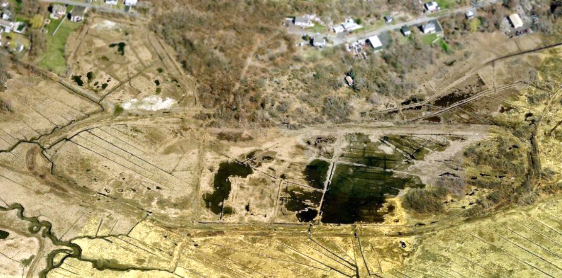
A circa 2010-2016 aerial view looking north at the remains of the oval racetrack of Franklin Park, within which was presumably the airfield of Saugus Field.
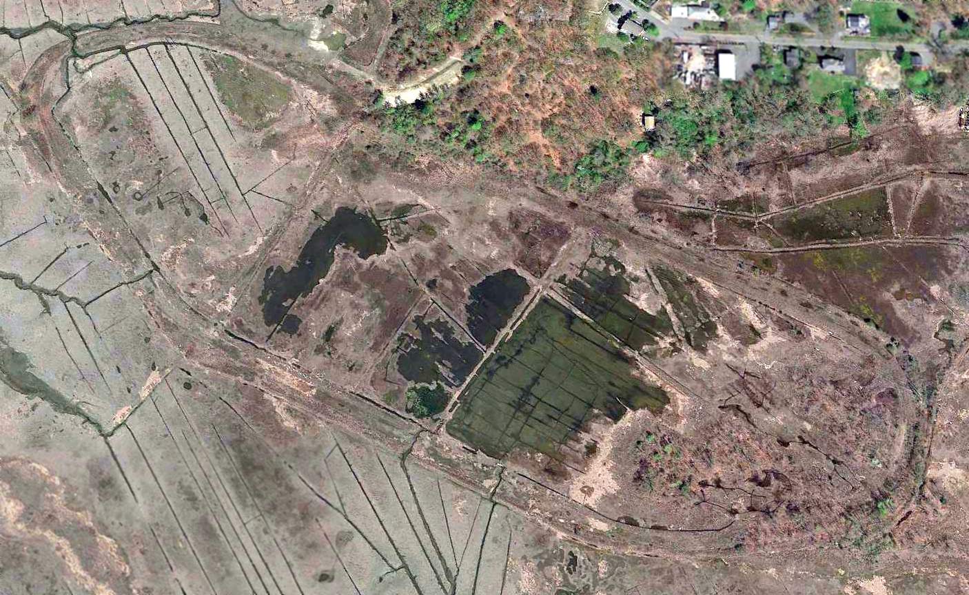
A 2016 aerial view looking northwest at the remains of the oval racetrack of Franklin Park, within which was presumably the airfield of Saugus Field.
The site of Saugus Field is is located south of the southwestern terminus of Saugus Avenue, appropriately enough.
Thanks to Sandy Muise for pointing out this airfield.
____________________________________________________
Billerica-Wilmington Airport, Billerica, MA
42.55, -71.21 (Northwest of Boston, MA)
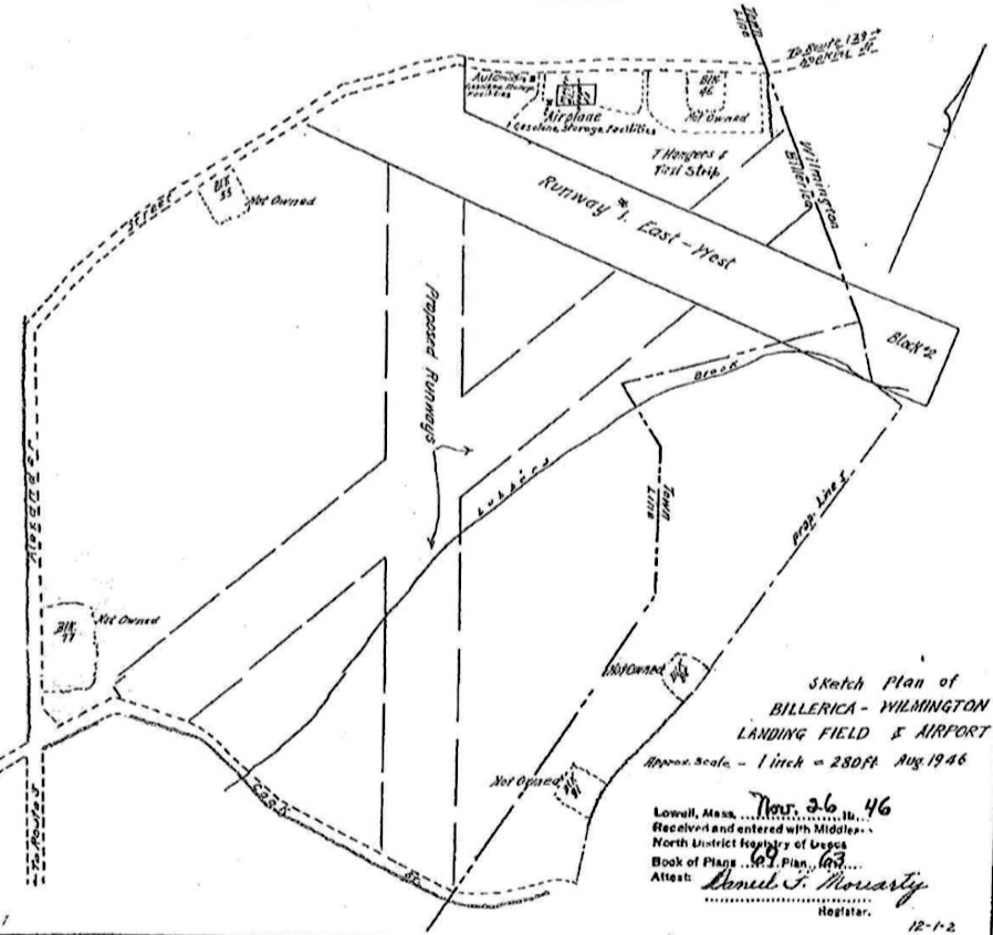
An August 1946 plan of the Billerica-Wilmington Airport from the Middlesex North Registry of Deeds (courtesy of Paul Chalifour).
No airfield was yet depicted at this location on a 1938 aerial photo,
nor listed among active airfields in the 1945 AAF Airfield Directory (courtesy of Scott Murdock).
According to an article in the 10/20/10 Wilmington Town Crier (courtesy of Glenn Bergeron),
“The airport was started in 1946 by a Woburn man, Russell Todman,
who built a small airstrip in a field on Hopkins Street, at the Wilmington - Billerica town line.
There was a hangar & a few J3 Piper Cubs.
Before long, auto dealer Fred Cain offered to go into a partnership with Todman.
Cain was then the 2nd-largest dealer for International Harvester trucks in New England.
With this equipment, Cain built Todman’s little airstrip into an airport.”
The article continued, “Cain then went to Texas, where he bought 3 AT-6 trainers & 2 twin-engine Cessnas.
He had them refurbished & flown to the little airport.
The airport had 2 hangars, Quonset hut buildings, next to Hopkins Street.
Cain brought in a flight instructor, John Hanson, and a mechanic, Larry Teed, who started a flight school.
Things went well until Todman allowed someone to take up a plane after only one lesson, after being told specifically not to do that.
The plane, an AT-6, only had one hour on it since being rebuilt.
The flight went well, except for the landing, when the plane hit a stone wall.
Frustrated with the lack of cooperation, Cain said he wanted to get out.
Hanson & Teed bought land in Tewksbury & established the Tew-Mac Airport.
The airport property was eventually sold for $45,000.”
Chuck Mason recalled, “It was opened in 1945 & I soloed there in October that year with Russ Todman as my instructor.
By the way, I set a record there that to my knowledge was never broken - I soloed in 4:20.
Johnny Hanson gave me my private check ride in April 1946.
I earned flying time at the airport as a line boy, 1 hour of solo time for 8 hours of work.
Frank Teed was the main mechanic there.
To earn my flying time I washed airplanes, did the line boy job, helped build the hangar
and did anything else around the airport to earn flying time which was $8/hour wet in a Piper J-3 Cub.
We flew on skis in the wintertime.”
The earliest depiction which has been located of Billerica-Wilmington Airport
was an August 1946 plan from the Middlesex North Registry of Deeds (courtesy of Paul Chalifour).
Notably it depicted a more elaborate planned airport than was ever built,
with a hangar on the north side of the single east/west runway, but also with 2 planned (but never-built) runways to the southwest.
Bob Bunton recalled, “Billerica/Wilmington, circa 1946, they had a bustling business with about 10 Cubs & many other types including UC-78s.
I got my first instruction there.”
John Collins recalled, “I remember seeing a sign on a hangar saying 'Authorized Cessna Service'.
I also remember an arrow on the roof of a veteran's organization building, near the Wilmington town green, pointing to this airport.
The building is no longer there [as of 2013].”
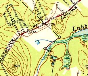
The 1950 USGS topo map depicted a clearing & 2 buildings at the location of Billerica-Wilmington Airport, but did not label the airport.
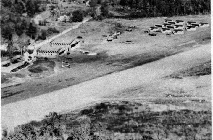
An undated aerial view looking northeast at Billerica-Wilmington Airport (courtesy of Paul Chalifour) showed the field having 2 arched-roof hangars,
a dozen T-hangars, and several light planes on the side of an unpaved runway.
Paul Chalifour observed, “This photo shows it probably in full operation so early 1950s I'm guessing.”
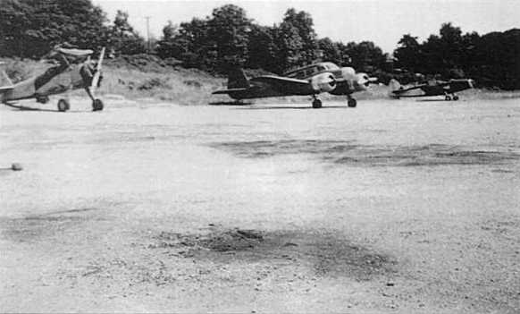
An undated (circa early 1950s?) photo of Billerica-Wilmingon Airport,
showing a biplane sans wings, a Cessna T-50, and a Fairchild PT-26.
According to Paul Chalifour, “My father says the airport was defunct as a business by the late 1950s
but remembers the strip still being used by local pilots for touch & go's in the 1960s.”
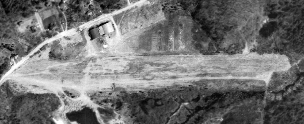
Billerica-Wilmington Airport was evidently closed by 1963,
as a 4/28/63 USGS aerial photo showed the field still remaining intact, but seemingly abandoned.
The Aerodromes table on the chart described Billerica-Wilmington as a private field having a single 1,300' bituminous runway,
with the crosswind runway evidently having been abandoned.
According to Paul Chalifour, “My first recollection is from 1968-69. I lived about a mile away & often drove by it with my parents.
I remember hiking through the woods from my childhood home about a mile or so away to play in the abandoned hangars.
As I recall they were corrugated Quonset-type buildings with checkerboard patterns on the roofs
(all that is left are partial pieces of their slab foundations).
There was also a nightclub adjacent called the 'Skyport Lounge'.”
A 1971 aerial view showed that the Billerica-Wilmington hangars still remained standing, and the runway remained intact, though deteriorated.
The June 1975 Boston Terminal Aeronautical Chart (courtesy of Mitchell Hymowitz)
no longer depicted Billerica-Wilmington Airport.
A 1978 aerial view showed that the hangars had been removed at some point between 1971-78,
but their foundations remained recognizable.
The area of the runway remained clear.
A 1995 aerial view showed that a large industrial building had been constructed over the site of the hangars.
The majority of the runway area remained clear, but was no longer recognizable as such.
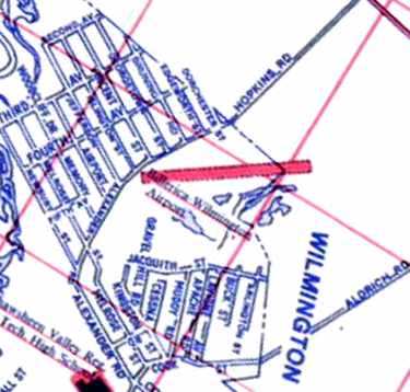
A 2000 street map annotated to show the location of the Billerica-Wilmington Airport runway (courtesy of Robert Atkinson).
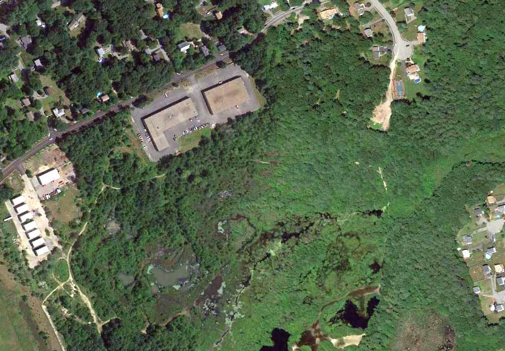
A 6/18/10 aerial photo showed the faintest trace of the former east/west runway in the woods at the site of Billerica-Wilmington Airport.
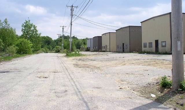
A 2000 photo by John Collins of the site of Billerica-Wilmington Airport.
Paul Chalifour reported in 2013, “The hangars, house (office), runway, and plane shelters are all gone.
However, the large farmhouse above the hangars still stands. It's on the corner of Dorchester Street & Alexander Road.
In the area of the single-plane shelters now stand 2 multi-bay single story industrial buildings.”
The site of Billerica-Wilgmington Airport is located northeast of the intersection of Alexander Street & Cessna Road, appropriately enough.
____________________________________________________
42.56, -70.96 (Northeast of Boston, MA)
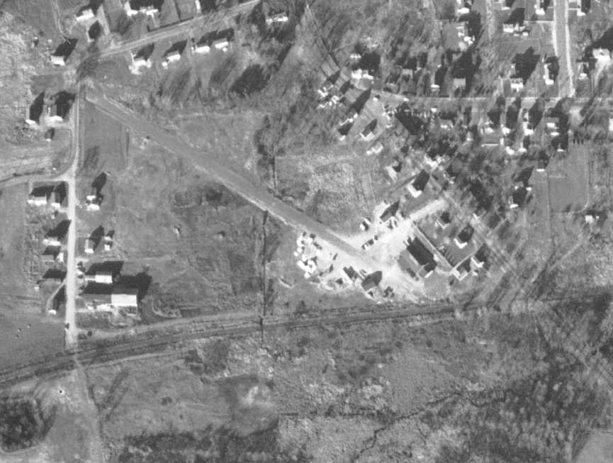
A 12/1/55 USGS aerial photo of Robbins Airport.
This private airfield was evidently established at some point between 1949-55,
as it was not yet depicted at all on a 1938 aerial photo, the 1945 Boston Sectional Chart (courtesy of John Voss),
or the 1949 USGS topo map.
The earliest depiction which has been located of Robbins Airport was a 12/1/55 USGS aerial view.
It depicted a single very short unpaved northwest/southeast runway, with some buildings on the southeast side.
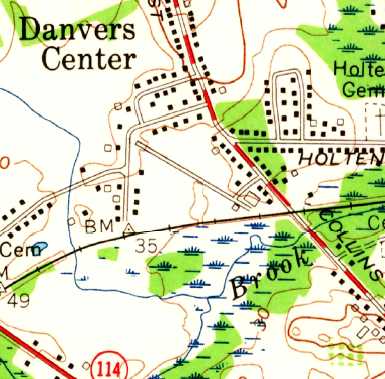
The 1956 USGS topo map depicted Robbins Airport as having a single northwest/southeast runway with several buildings, but did not label the airport.
According to John Ford of Les Vants Aerial Photos, “I know it was operational in the late 1950s.”
However, it was not yet depicted at all on the June 1959 Boston Local Aeronautical Chart (according to Chris Kennedy).
The earliest official reference to Robbins Airport which has been located was in the 1962 AOPA Airport Directory.
It described Robbins as a private field, operated by Earle Robbins,
having a 1,400' paved Runway 13/31 & a 1,500' sod Runway 9/27.
Robbins was described in the same manner in the 1963 AOPA Airport Directory (courtesy of Chris Kennedy).
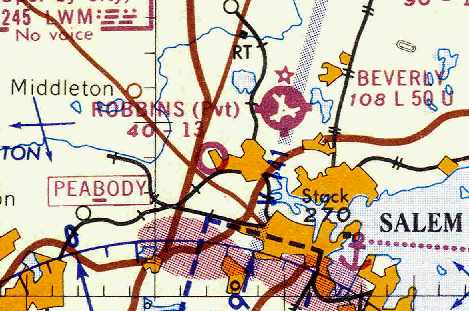
The earliest aeronautical chart depiction of Robbins Airport which has been located
was on the March 1963 Boston Sectional Chart (courtesy of Chris Kennedy).
The Aerodromes table on the chart described Robbins as a private field having a single 1,300' bituminous runway,
with the crosswind runway evidently having been abandoned.
David Savage recalled, “I did a little flying out of Robbins Field.
It was a private field & before Earle Robbins would let you fly into it, you had to drive in & get checked out by him or one of his instructors.
He threatened to have anyone arrested for trespassing if they did not follow his rules.
It was a short runway with a lot of obstacles, but by pilots following his rules, they had an excellent safety record.”
Al Palladino recalled that Robbins was “owned & operated by Earl Robbins
who was also the only flight instructor & also owned an adjoining lumber yard.
His strip was very small & demanding however Earl was a great instructor.”

The Aerodromes table on the 1965 Boston Sectional Chart (courtesy of John Voss)
described Robbins as a private field with a single 1,461' bituminous runway.
The status of Robbins Airport may have changed to a public-use airfield at some point between 1963-67,
as the 1967 AOPA Airport Directory (courtesy of Chris Kennedy) gave no indication of the field being private.
The field had a single 1,500' bituminous-concrete Runway 10/28.
The operator was listed as Robbins Air Taxi Service,
and the field was listed as offering fuel, minor repairs, hangars, tie-downs, and charter.
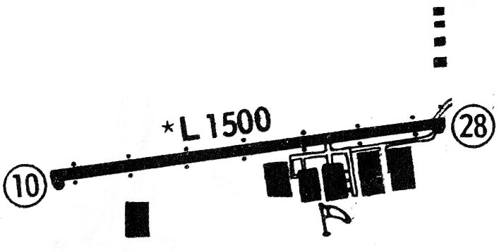
The 1968 Flight Guide (courtesy of Robert Levittan) depicted Robbins as having a single paved 1,500' Runway 10/28,
with 5 large hangars on the southeast side, and 4 smaller buildings on the northeast side.
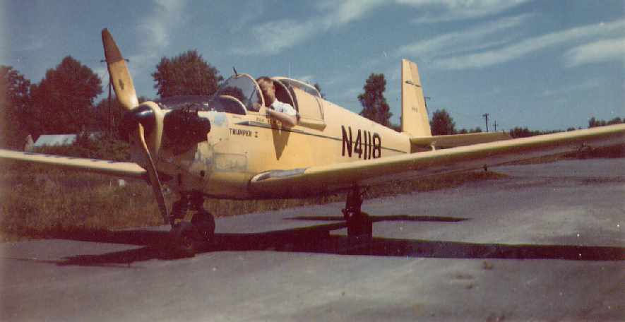
A 1968 photo (courtesy of Scott Traill) of his father (Dusty Traill)
in a single-seat Mooney Mite (“Thumper 1”) on the runway at Robbins.
A 1969 aerial view showed that Robbins had a single east/west paved runway.
The former northeast/southwest runway was still visible, but appeared to be abandoned.
Several hangars were on the south side, along with 9 light aircraft.
Scott Traill recalled, “My Dad [Dusty Traill] flew out of Robbins Airfield on a regular basis during the 1960s & early 1970s.
Mostly he flew a Tripacer with a (new at the time) folding computerized night-sign
that was towed behind the plane over Fenway in Boston & surrounding areas at night.
It was a very busy little airport at the time & I will always remember going for plane rides as a child from there.”
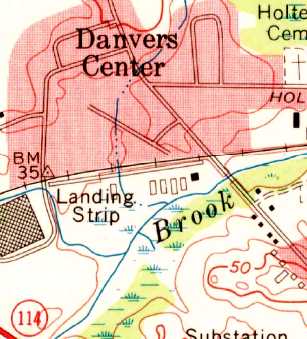
The 1970 USGS topo map depicted Robbins as having a single east/west paved runway, labeled simply as “Landing Strip”.
The former northwest/southeast runway on the opposite side of the railroad tracks was depicted as having become a street.
The status of Robbins Airport evidently changed back to a private field at some point between 1967-71,
as that is how it was depicted on the January 1971 NY Sectional Chart (courtesy of Chris Kennedy).

A 1971 aerial view depicted Robbins Airport as having a single paved east/west runway.
A total of 6 hangars were located along the south side of the field,
and 2 light aircraft were visible parked outside.
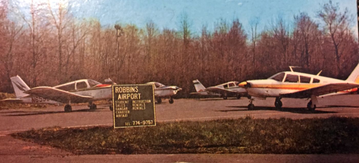
An undated (circa 1970s?) photo of 4 Pipers & the Robbins Airport sign (courtesy of Earlene Robbins Goodwin).
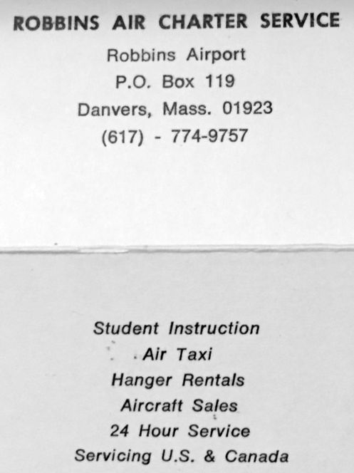
An undated (circa 1970s?) business card for Robbins Air Charter Service (courtesy of Earlene Robbins Goodwin).
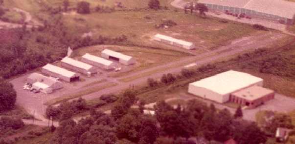
A 1972 aerial view looking southwest at Robbins Airport by John Barnes (courtesy of Brian Barnes).
The airport office was visible at left, with another 5 hangar buildings on the south side of the runway.
A single aircraft was visible parked outside.
John recalled, “I learned to fly at Robbins Airport that year.”
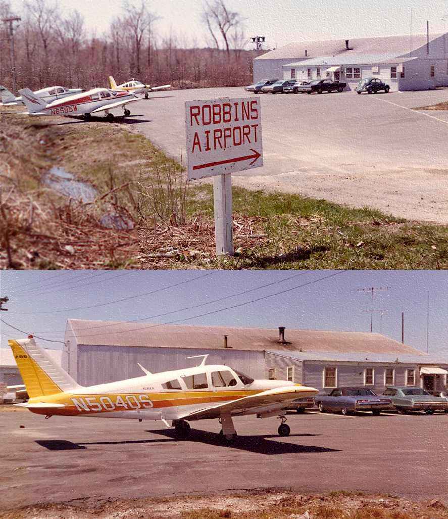
Two 1972 photos of the Robbins Airport ramp & office by John Barnes (courtesy of Brian Barnes),
showing 3 Pipers parked on outside.
Rand Peck recalled, “I instructed at the Beverly Airport from 1972-74
and remember Robbins Airport, located just off the end of our westbound runway.
I never landed there but remember seeing airplanes parked at the field as we flew over
and do remember an occasional arrival & departure down there too.
Beverly of course, was an uncontrolled field at that time, so little conflict existed.”
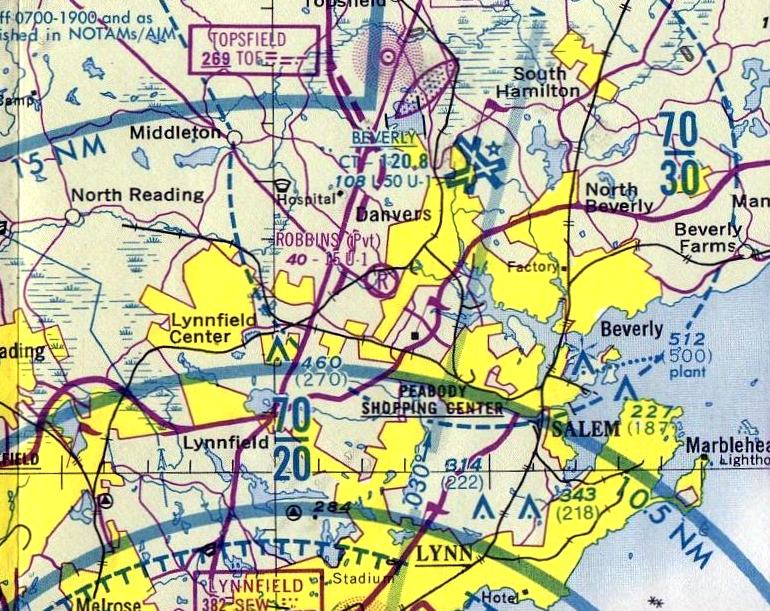
The last aeronautical chart depiction which has been located of Robbins Airport
was on the June 1975 Boston Terminal Aeronautical Chart (courtesy of Mitchell Hymowitz).
It depicted Robbins as a private field having a 1,500' unpaved runway.
Robbins Airport was no longer depicted at all on the 1977 USGS topo map.
According to John Ford of Les Vants Aerial Photos, Robbins Airport “closed around 1978.”
A 1978 aerial photo showed Robbins Airport appearing still largely intact,
but no aircraft were visible on the field, and the western-most hangar had been replaced by a large building (presumably not airport-related).
However, Robbins was still listed as an active airfield
in the 1982 AOPA Airports USA Directory (courtesy of Chris Kennedy),
although it was noted to be “Private. Closed to public.”
It was described as having a single 1,500' asphalt Runway 10/28.
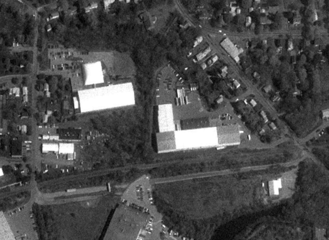
Robbins Airport was evidently closed at some point between 1982-96,
as the 1996 USGS aerial photo showed that the middle of the paved runway had been bisected by the parking lot of a large building
which had been constructed on the south side of the former airport property.
The remainder of the length of the runway was otherwise intact.
Five hangars had been removed at some point between 1971-96,
leaving only a single hangar on the southeast side of the field.
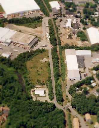
A July 1999 aerial photo by John Ford of Les Vants Aerial Photos
looking west at the site of Robbins Airport, with the remains of the former paved runway still intact.
A single hangar still remained standing, at the bottom-left of the photo.
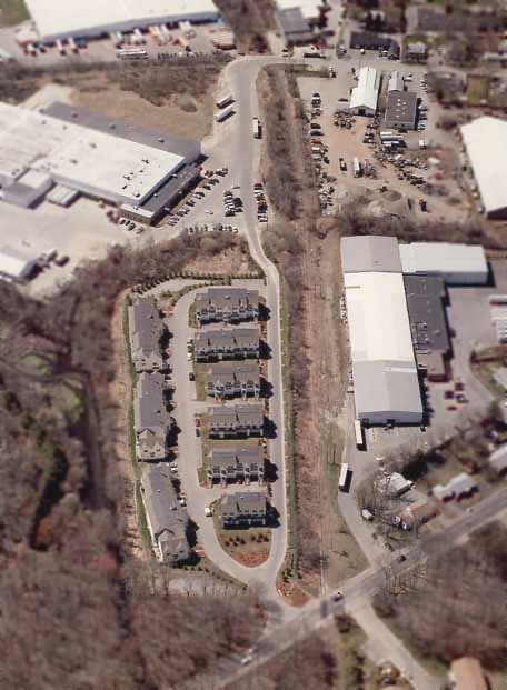
An April 2005 aerial photo by John Ford of Les Vants Aerial Photos looking west at the site of Robbins Airport.
By comparing with the 1999 aerial photo, it can be seen that townhouse development
had covered the eastern end of the former runway at some point between 1999-2005.
The remains of the western half of the former runway were still visible at the top of the photo.
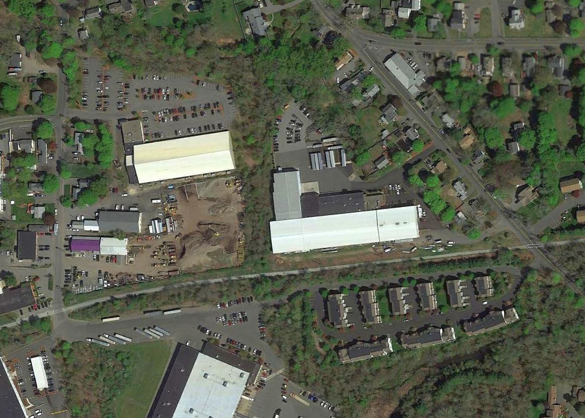
A 2016 aerial view showed the remains of the western half of the runway were the sole remaining trace of Robbins Airport.
Earlene Robbins Goodwin reported in 2016, “My father was Earle Robbins.
The condos on the edge of the old runway are named Robbins Landing. What a thrill to see that sign. I don't know who honored my father like that.”
The site of Robbins Airport is located south of the intersection of Collins Street & Holten Street.
____________________________________________________
Muller Field / Riverside Airport / Revere Airport, Revere, MA
42.43, -71.02 (North of Logan Airport, MA)
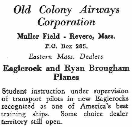
An advertisement for Old Colony Airways Corporation at Muller Field
from the 4/23/28 issue of Aviation Magazine (courtesy of Chris Kennedy).
This former general aviation airport & seaplane base was located along the southwestern bank of the Pines River.
The date of construction of Muller Field is unknown.
The earliest reference to Mueller Field which has been located
was an advertisement for Old Colony Airways Corporation at Muller Field
from the 4/23/28 issue of Aviation Magazine (courtesy of Chris Kennedy).
According to the MA Aviation Historical Society's 2015 Calendar (courtesy of Bill Deane),
“The meandering inlet just beyond the airfield was dredged for a seaplane base, later canceled.
The fill was used for Logan Airport runways.”
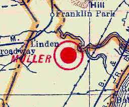
The earliest depiction of Mueller Field which has been located
was on the 1929 Rand-McNally Air Trails Map of Massachusetts (courtesy of Chris Kennedy).
It described Muller Field as a commercial field operated by the Old Colony Airways Corporation.
It was said to consist of a 1,500' x 1,000' field.
The July 1931 Airports & Landing Fields in New England (courtesy of Chris Kennedy)
described Muller Field as a private airfield, consisting of a 290 acre sod field.
It was said to have 2 runways (2,500' northeast/southwest & 1,500' east/west) and 3 hangars.
The commercial operators were listed as Beacon Airways & A.T. Zwink,
and the owner was listed as William Muller.
Rich Cardinale recalled, “My family literally lived across the street
since my grandfather bought land there in 1909.
My father remembers it as a young boy as being a busy little place.”
The Airport Directory Company's 1933 Airport Directory (courtesy of Chris Kennedy)
described Muller as a commercial field, consisting of a 200 acre sod field.
It was said to have 2 runways (2,500' northwest/southeast & 1,500' northeast/southwest).
A hangar was said to be marked with “Muller Field”.
In the early 1930s, the Gee Bee Sporter Model B had a restricted license,
and was restricted to exhibition flights at Muller Field, Revere.
A biography of Julius Goldman said that he took his first flight at Muller Field in the early 1930s.
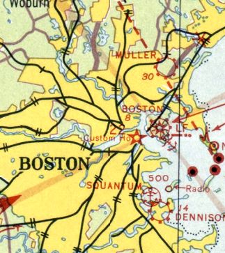
The earliest aeronautical chart depiction of Mueller Field which has been located was on the 1933 Boston Sectional Chart.
It depicted Muller as a commercial/municipal airport.
Muller Field was listed among active airfields in the 1934 Commerce Department Airfield Directory (according to Chris Kennedy).
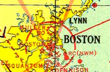
The 1935 Regional Aeronautical Chart (courtesy of Scott O'Donnell)
depicted Muller Field as a commercial or municipal airport.
The Airport Directory Company's 1937 Airport Directory (courtesy of Bob Rambo)
described Muller Field as a commercial airfield, consisting of a 200 acre sod field.
It was said to have 2 runways in an L-shape,
measuring 2,500' northwest/southeast & 1,500' northeast/southwest.
A hangar was said to be marked with “Muller Field”.
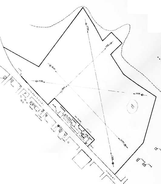
The 1937 “Progress Report of the Committee For Aeronautics of the Commonwealth of MA” (courtesy of Jonathan Westerling)
depicted Revere Airport as an irregularly-shaped field within which the longest landing distance was 1,600' north/south.
Three hangars & an office building were depicted on the southwest side of the field.
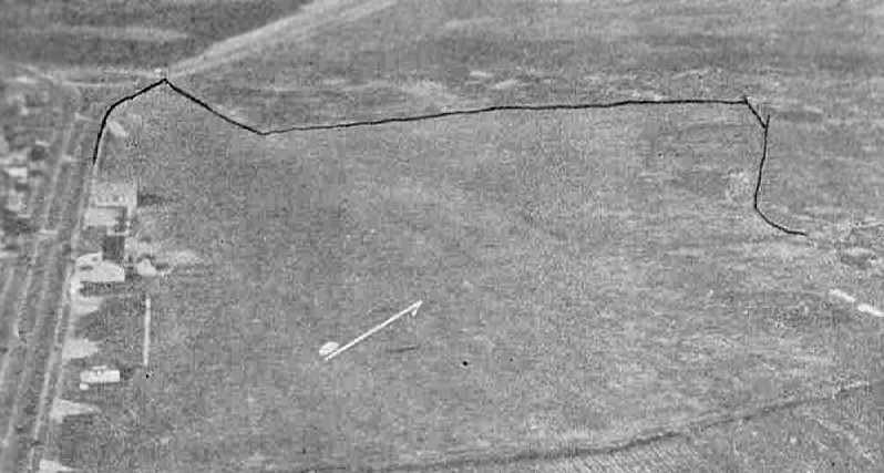
Muller Field was evidently renamed “Riverside” at some point between 1937-38,
as that is how it was listed in The Airport Directory Company's 1938 Airport Directory (courtesy of Chris Kennedy).
An aerial view looking northwest at the field depicted it as having a row of hangars along the southwest side.
Strangely, the field was described as much smaller than only the year before – only 60 acres in size.
It was said to have 2 runways, measuring 2,000' northwest/southeast & 1,200' northeast/southwest.
A hangar was said to be marked with “Revere”.
David Rosen recalled, “As a youngster in the 1930s & 1940s I remember watching small planes land & take off at the Revere Airport.”
Riverside Airport was described in The Airport Directory Company's 1941 Airport Directory (courtesy of Chris Kennedy)
as a commercial field, consisting of an irregularly-shaped 60 acre sod property.
However, the number of runways had increased to 3 – with the longest being a 2,000' north/south strip.
A hangar was said to be marked with “Revere”.
The May 1941 Boston Sectional Chart (courtesy of Chris Kennedy)
depicted Riverside as a commercial/municipal field.
Carole McCarthy reported, “My father received his Private Pilot License from the Bayside Flying Service Inc. which operated out of Muller Airport in 1941.”
Inexplicably, the airport may have reverted to its original name by 1942,
as it was once again depicted as “Muller” on the November 1942 & May 1943 Boston Sectional Charts (courtesy of Chris Kennedy).
Muller Airport was evidently closed at some point between 1943-44,
as it was not depicted at all on the November 1944, June 1945,
or December 1945 Boston Sectional Charts (according to Chris Kennedy),
nor depicted on the 1946 USGS topo map.
It is possible that the airfield may have been temporarily closed during WW2
(as was the case at many other small civilian airports, due to wartime security concerns).
According to David Rosen, “During WWII the airport became a military installation with test runs for small tracked military vehicles.”
In 1946 Julius Goldman purchased Muller Field & opened Revere Airways,
which he operated as President, general manager and chief pilot from 1946-61.
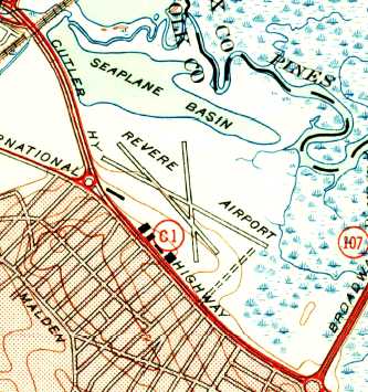
The former Muller Field had evidently been renamed Revere Airport after being purchased by the owner of Revere Airways,
as the 1946 USGS topo map labeled the field as "Revere Airport".
It depicted Revere Airport as having 3 runways (with the longest being 3,000'), with 5 hangars along the southwest side.
The pond northwest of the runways was labeled as a "Seaplane Basin".
According to David Rosen, “The airport reopened after the war.
There was a time in the late 1940s, in the summer, when an advertising blimp anchored there,
in addition to the regular lineup of Piper Cubs, Aeroncas, Cessnas etc.”
The 1950 USGS topo map depicted Revere Airport in the same fashion as the 1946 topo map.
Of Revere Airport, Sal Gesamondo recalled,
"It is the place I took my first airplane ride in a Piper Tri-Pacer for $2.50."
Wayne Irwin recalled, "When I was a kid & living in the Greater Boston area,
my father used to take my brother & I to a small airport in Revere.
I remember quite clearly being parked next to it & watching small aircraft take off & land.
This would have been in the late 1940s & early 1950s."
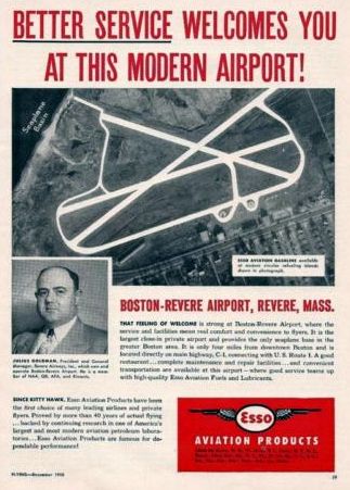
A 1950 advertisement for Revere Airport featured an undated aerial photo highlighting 3 paved runways & an adjacent Seaplane Basin.
The 1950 USAF Pilot's Handbook (courtesy of Chris Kennedy)
depicted Revere as having an airport & adjacent seaplane base.
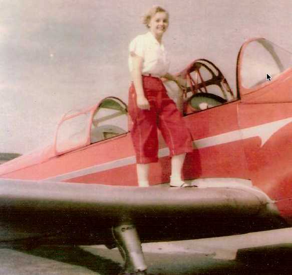
A 1953 photo of Elizabeth Haynes upon “Firebird”, her PT-23 at Revere Airport.
Elizabeth recalled, “I bought a war surplus Fairchild PT-23, NC 40014, (built by the St. Louis Boxcar Co.) for $500 shortly after the war,
and flew it from Bailey's Crossroads Airport [VA] to Revere Field, north of Boston.
I was a lieutenant in the Air Force at the time & was attending graduate school in meteorology.
I earned my private [pilot's] license there in 1953.
Flying home from Revere to Hybla Valley [VA], I could beat Eastern Airlines in DC-3s changing planes at LaGuardia.”
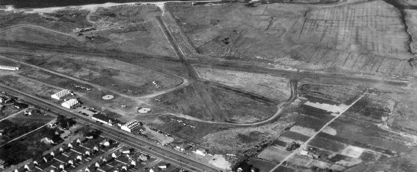
A 1954 aerial view looking northeast at Revere Airport (from the MA Aviation Historical Society's 2015 Calendar, courtesy of Bill Deane)
depicted it as having 3 runways, several hangars with checkerboard roofs on the southwest side,
and a dozen single-engine aircraft visible parked outside.
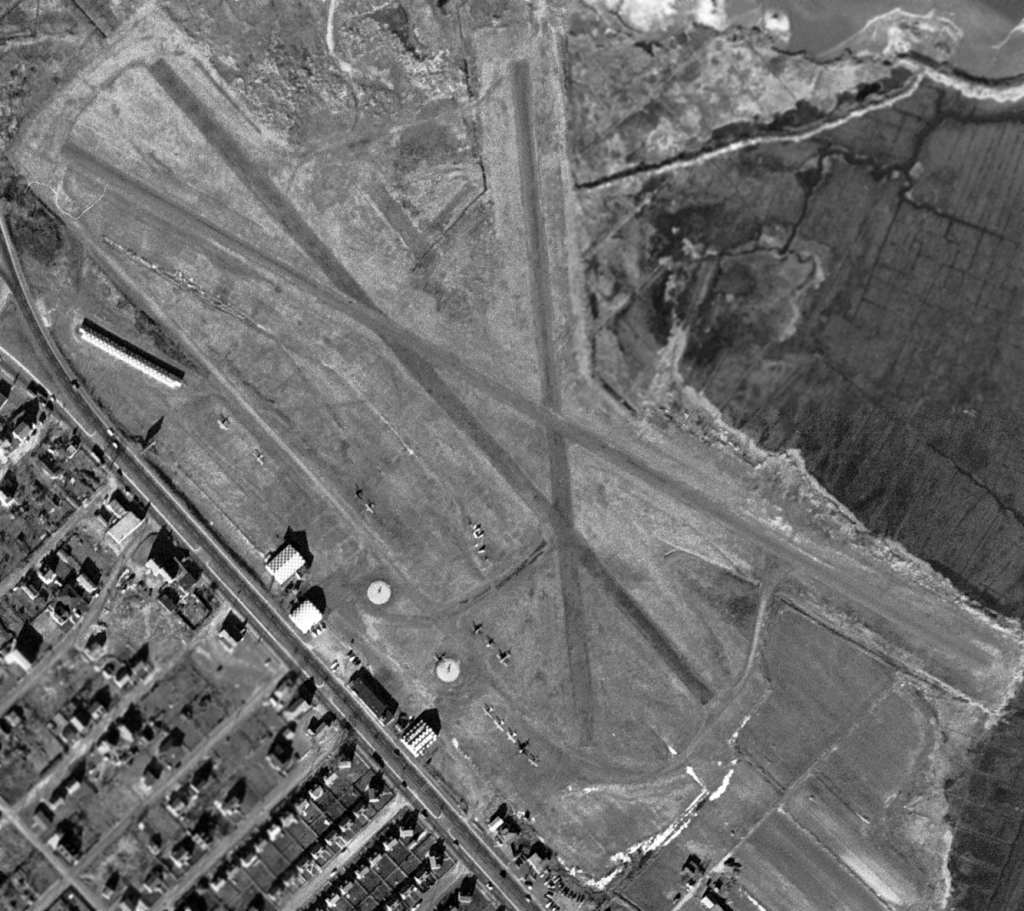
The last photo which has been located showing Revere Airport was a 12/1/55 USGS aerial view.
It showed Revere Airport to have 3 runways, several hangars with checkerboard roofs on the southwest side,
and a dozen single-engine aircraft visible parked outside.
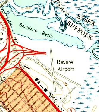
The 1956 USGS topo map still depicted Revere Airport, but between 1950-56 a new highway interchange had been built on the northwest side of the airport,
perilously close to the runways.
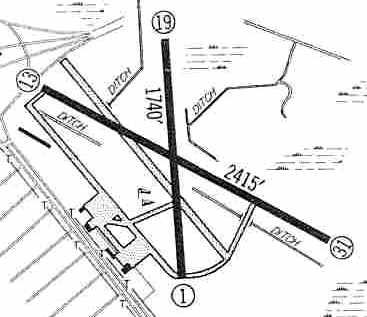
The 1960 Jeppesen Airway Manual (courtesy of Chris Kennedy)
depicted Revere Airport as having 2 paved runways (2,415' Runway 13/31 & 1,740' Runway 1/19) as well as a 3rd (abandoned) runway.
Taxiways led to a ramp on the southwest side of the field with several small hangars.
In 1961, Revere Airways moved from Revere Airport to Beverly Airport.
Revere Airport, as depicted on the November 1961 Boston Local Aeronautical Chart (courtesy of Mike Keefe).
By 1962, Revere's runways had shrunken both in number & length.
The 1962 AOPA Airport Directory described Revere as having 2 bituminous runways:
2,400' Runway 13/31 & 1,750' Runway 1/19.
The operator was listed as Revere Airways Inc.
The Revere Seaplane Base was described as having a 3,300' water landing lane 13/31,
but the remarks said "Emergency use only."
According to a 4/24/62 Boston Globe article (courtesy of Peter Diforte), Revere Airport closed the previous day, 4/23/2.
The 50 based aircraft were to be moved in a "2 day mass flyover" to Beverly Airport.
Four of the "original" 11 hangars remained at closure.
Industrial centers were eating away at the hangars, and the taxes were too high in Revere.
A main reason for closure was the planned construction of the Northeast Expressway, which ironically was abandoned in the early 1970s & never constructed.
Revere Airport was not depicted at all on the December 1962 Boston Local Aeronautical Chart (courtesy of Mike Keefe).
According to David Rosen, an arch-roof hangar on the airport's southwestern end
“was converted into an appliance retail store when the airport finally closed down.”
A 1969 aerial photo showed that the site of Revere Airport had been redeveloped as the Northgate Shopping Center.
As seen in a circa 2001 aerial view of the site, not a trace appeared to remain of the former airport.
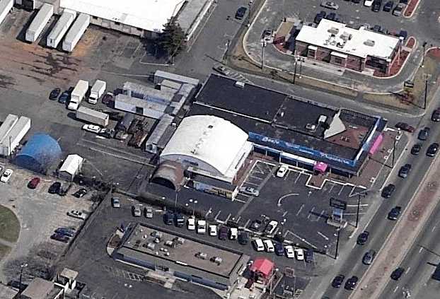
A circa 2006 aerial view looking east at an former hangar which remains standing on the southwestern portion of the former airport.
David Rosen reported in 2009 that the former hangar on the southwestern portion of the former airport was still standing,
as a Sozio furniture store.
The site of Revere Airport is located northwest of the intersection of Cutler Highway & Broadway.
____________________________________________________
Salem Coast Guard Air Station, Salem, MA
42.53, -70.87 (Northeast of Boston, MA)
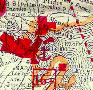
The Salem Seaplane Anchorage, as depicted on the 1929 Rand-McNally Air Trails Map of Massachusetts (courtesy of Chris Kennedy).
The earliest depiction of a seaplane facility in Salem which has been located
was on the 1929 Rand-McNally Air Trails Map of Massachusetts (courtesy of Chris Kennedy).
It listed the facility as the Salem "Seaplane Anchorage", but did not describe the operator of the facility or any other details.
In 1935 the Coast Guard established a seaplane facility in Salem, to replace a smaller installation in Gloucester.
The base was located on a peninsula, Salem Neck, which juts out into Salem Harbor.
Salem boasted what were at the time state of the art communications & modern repair facilities,
being designed to handle the larger flying boats of the time.
Its aviation facilities consisted of a single hangar, a paved 250' square parking apron,
and 2 seaplane ramps leading down into the waters of Salem Harbor.
CGAS Salem performed a total of 26 medevac missions during its first year of operation,
according to an article in the June 2004 issue of Naval Aviation News (courtesy of John Voss).
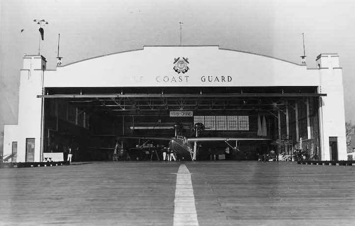
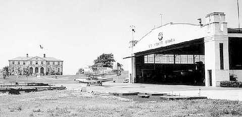
A circa 1938 photo looking northwest at Coast Guard Air Station Salem, showing a Curtiss SOC-4 Seagull on the ramp & a Fokker-General Aviation PJ-1 in the hangar.
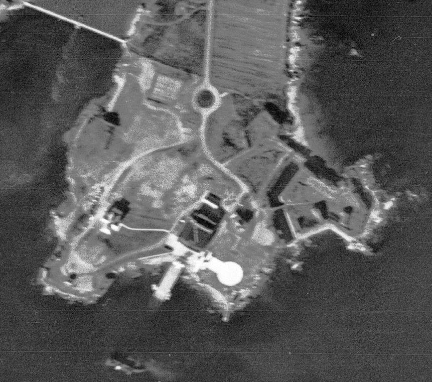
An 11/20/38 USGS aerial photo showed Salem as having a hangar & seaplane ramp.
One or possibly 2 aircraft were visible on the ramp.
In 1941 air crews from Salem began to fly neutrality patrols along the coast.
The years of the Second World War saw the air station roster increase to 37 aircraft,
making it the second largest Coast Guard station on the east coast.
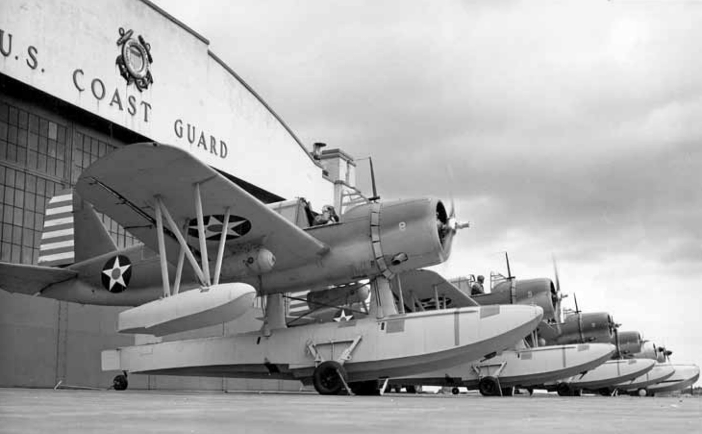
A 1943 photo of 4 Vought OS2U-3 Kingfishers assigned to antisubmarine duty at USCG Air Station Salem (USCG photo from the C.H. Hamilton collection).
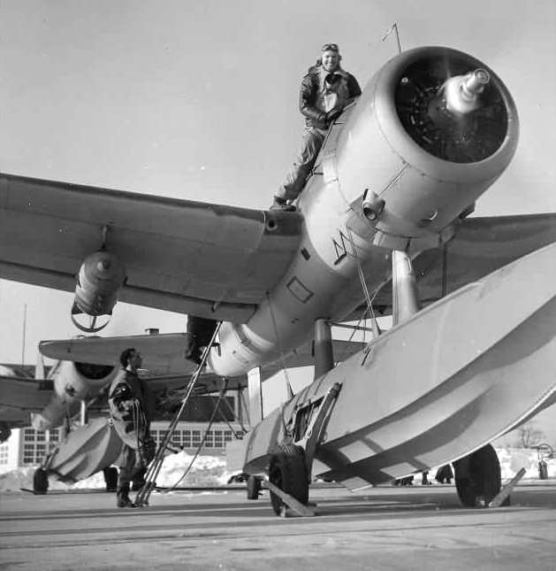
A 1944 photo of an OS2U-3 loaded with depth charges preparing to launch from CGAS Salem.
In October 1944, Air Station Salem was officially designated
as the first US Air-Sea Rescue service on the eastern seaboard.
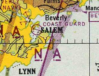
Salem CGAS, as depicted on the November 1944 Boston Sectional Chart (courtesy of Chris Kennedy).
Salem CGAS was not yet depicted on the 1945 USGS topo map.
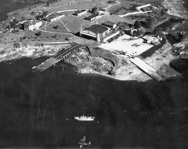
A 1945 aerial view looking north at CGAS Salem,
with several aircraft on the ramp, and one flying by at the bottom of the photo.

A 1945 photo of 2 PBM flying boats on the ramp at CGAS Salem.
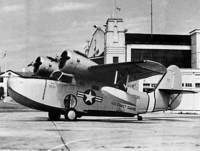
An undated view of a Grumman Goose amphibian flying boat on the ramp at Salem CGAS.
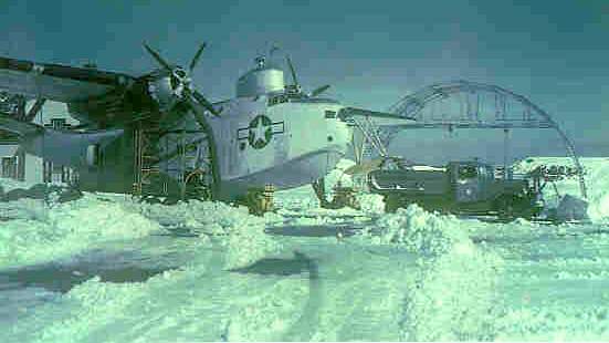
An undated view of a PBM flying boat on a snowy ramp at Salem.
After the war the Coast Guard found itself with a varied inventory
of helicopters, multi-engined patrol planes, and flying boats.

A 1947 photo of Ltjg. John Weber
at the instructor station of a Link Trainer (an early flight simulator) at CGAS Salem.
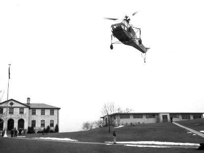
A circa 1952 demonstration of a Sikorsky HNS-1 helicopter at CGAS Salem.
A 1955 aerial view showed one Coast Guard flying boat on the water just off Salem's ramp,
and at least one other flying boat on the apron.
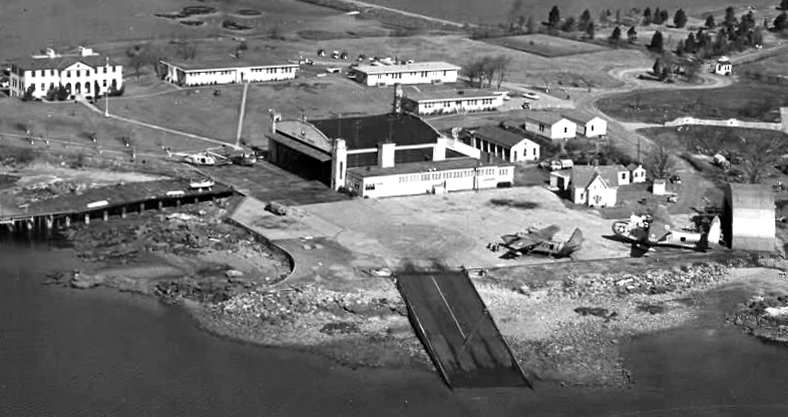
showing 2 helicopters & 2 flying boats on the ramp.
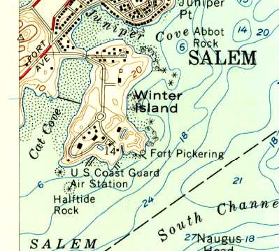
The 1956 USGS topo map depicted “U.S. Coast Guard Air Station”.
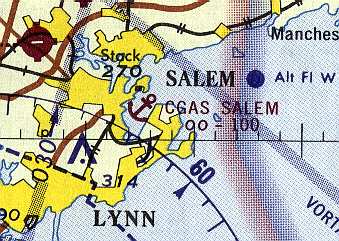
CGAS Salem, as depicted on the 1968 Boston Sectional Chart (courtesy of Mike Keefe).
The last photo which has been located showing CGAS still in operation was a 1969 aerial view,
which showed 2 flying boats on the ramp.
With no runways to handle land-plane operations at Salem,
the Coast Guard eventually began to search for a replacement facility for Massachusetts area flight operations.
Salem CGAS was closed in 1970,
and Coast Guard operations were moved to Otis Field.
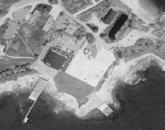
A 1971 aerial view of Salem, only a year after it was closed.
The ramp had 2 helipad circles painted on it at some point between 1969-71.
The historic CGAS Salem property was turned over to the City of Salem in 1972,
but the facilities of the former Coast Guard Air Station were allowed to slowly deteriorate.
In the 1990s a proposal was brought forth to tear down the hangar & replace it with a parking lot,
but this was not carried out.
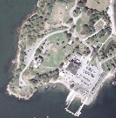
As of a 2000 aerial view, the seaplane facilities appear to have remained intact.
As of 2003, the property of the former Salem CGAS is reused as the Winter Island Marine Park.
According to an article in the June 2004 issue of Naval Aviation News (courtesy of John Voss),
as of 2004 the original hangar, barracks, dining facility, radio shack,
and motor pool building remained standing, but in poor condition.
An organization called Historic Salem Inc. is attempting to ensure that the property will be preserved.
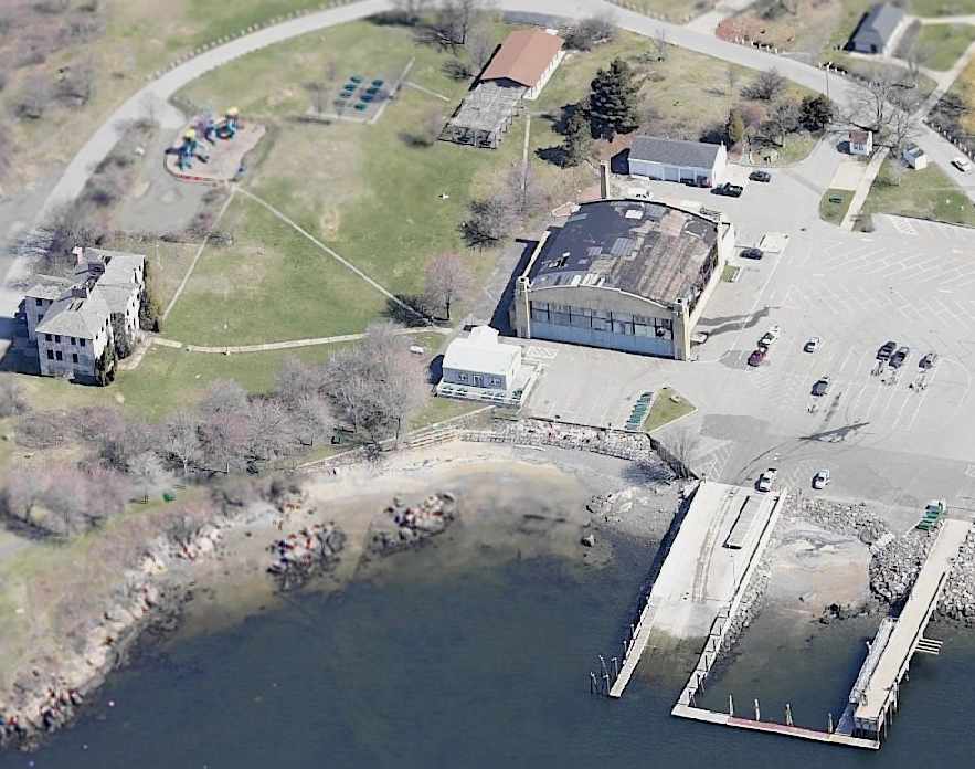
A circa 2005 aerial view looking north at the former Salem Headquarters building, hangar, and ramp.
____________________________________________________
Since this site was first put on the web in 1999, its popularity has grown tremendously.
That has caused it to often exceed bandwidth limitations
set by the company which I pay to host it on the web.
If the total quantity of material on this site is to continue to grow,
it will require ever-increasing funding to pay its expenses.
Therefore, I request financial contributions from site visitors,
to help defray the increasing costs of the site
and ensure that it continues to be available & to grow.
What would you pay for a good aviation magazine, or a good aviation book?
Please consider a donation of an equivalent amount, at the least.
This site is not supported by commercial advertising –
it is purely supported by donations.
If you enjoy the site, and would like to make a financial contribution,
you
may use a credit card via
![]() ,
using one of 2 methods:
,
using one of 2 methods:
To make a one-time donation of an amount of your choice:
Or you can sign up for a $10 monthly subscription to help support the site on an ongoing basis:
Or if you prefer to contact me directly concerning a contribution (for a mailing address to send a check),
please contact me at: paulandterryfreeman@gmail.com
If you enjoy this web site, please support it with a financial contribution.
please contact me at: paulandterryfreeman@gmail.com
If you enjoy this web site, please support it with a financial contribution.
____________________________________________________
This site covers airfields in all 50 states.