
Abandoned & Little-Known Airfields:
Maryland: Howard County
© 2002, © 2015 by Paul Freeman. Revised 7/8/15.
This site covers airfields in all 50 states: Click here for the site's main menu.
____________________________________________________
Please consider a financial contribution to support the continued growth & operation of this site.
Columbia Airfield (revised 5/24/09) - Haysfield Airport (revised 1/20/13) - Turf Valley Airfield (revised 7/8/15)
____________________________________________________
Haysfield Airport (MD24), Clarksville, MD
39.24 North / 76.94 West (Southwest of Baltimore, MD)
Haysfield was depicted as “Landing Strip” on the 1971 USGS topo map.
Sherry Peruzzi reported, “From the 1940s until the mid 1960s,
Alfred Bassler operated a grass strip located on the family farm on the current site of Howard County General Hospital,
at what is now the intersection of Cedar Lane & Little Patuxent Parkway.”
A 1966 aerial photo did not yet show any sign of Haysfield Airport.
Sherry Peruzzi reported, “When Columbia was planned, Al [Bassler] & his family were one of the last landowners to sell;
in order to get the land to build the hospital, he was given a sum of money plus 500 acres off Shepard Lane in Clarksville.
He built a new grass strip there, which is has been operating since the late 1960s as Haysfield Airport (MD24).”
According to a 7/20/03 article in the Baltimore Sun,
Haysfield was “opened in 1968 by Alfred Bassler.”
However, a slightly later timeframe is given in a 12/19/13 Baltimore Sun article (courtesy of Ron Plante):
“After moving to Sheppard Lane in May 1970, building a hangar & establishing a grass airstrip on his share of the land were Alfred's top priorities.
He created a 3,000' runway that started at the top of a hill.”
The earliest depiction of Haysfield which has been located was on the 1971 USGS topo map.
It depicted a single unpaved northwest/southeast runway, with a few small buildings along the west side,
labeled simply as “Landing Strip”.
According to its FAA Airport/Facility Directory data, Haysfield was established in September 1974.
According to a 12/19/13 Baltimore Sun article (courtesy of Ron Plante): “He [Alfred Bassler] and opened for business in 1974.”
"I felt I was doing the county a favor by establishing a public-use airport," he said, adding that some people didn't share that view.
Zoning battles played out over the years, but all were resolved.
Haysfield was the culmination of a long-held dream for Alfred, going all the way back to his model-airplane-building days in 5th grade.
He & Patsy approached running their airport with gusto.
The couple joined a chapter of Flying Farmers, whose members flew to each other's farms in the county.
In 1978 they also helped establish the Howard County Pilots Association, which boasted a roster of 120 members.”

The 1979 USGS topo map depicted a single unpaved northwest/southeast runway,
with a few small buildings along the west side, but the field was not labeled.
According to a 12/19/13 Baltimore Sun article (courtesy of Ron Plante): “Though Alfred was a pilot before he & Patsy became sweethearts,
she remained afraid of flying for many years, even after establishing a plane rental company & flight school called Flite Rentals in 1982 with older son, David.”
Sherry Peruzzi reported, “I learned to fly at Haysfield in 1983, and was friends with the Basslers for some years.”

The earliest aeronautical chart depiction which has been located of Haysfield
was on a 1993 Washington Sectional Chart.
It depicted Haysfield as a private field with an unpaved runway.

The 4/7/93 USGS aerial photo depicted dozens of single-engine aircraft parked at Haysfield,
both along the south side of the runway & along an offshoot on the northwest side.
Jan Smith recalled of Haysfield, “The airport had been used for many years as a summer meeting spot for the local Quiet Birdmen.
Area pilots have fond memories of Haysfield.
A pilot who was getting his tail-dragger endorsement there... When he went up with his examiner,
another pilot on the ground thought he'd help out by walking to the end of the runway, dropping his drawers, and presenting the approaching aircraft with a vertical VASI of sorts.
Back in the airplane, the pilot & examiner first asked each other what that was by the end of the runway.
As they approached closer, the pilot realized what they were looking at & started laughing so hard he had to make a go-around.”
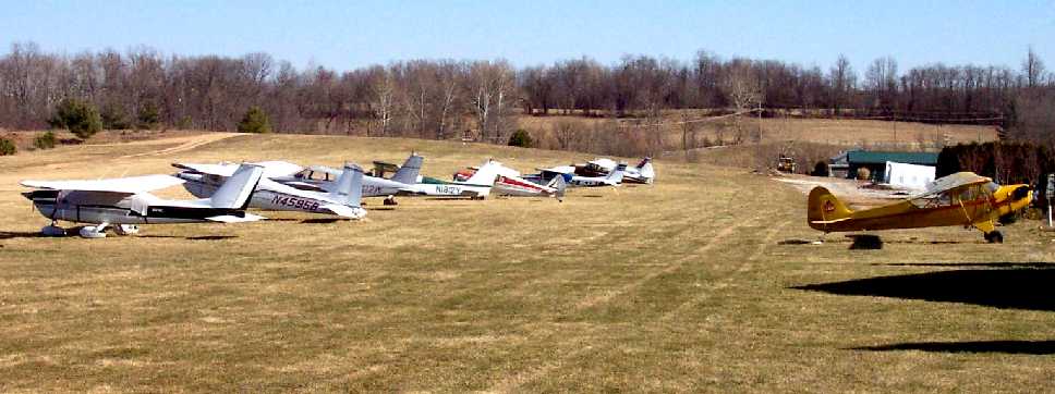
A 2002 photo by Paul Freeman showing several light single-engine aircraft parked at Haysfield.

A 2002 photo by Paul Freeman showing a Citabria taking off at Haysfield.

A circa 2006-2010 aerial view looking west at 15 light single-engine aircraft parked at Haysfield.
Jan Smith reported, “It was supposed to close & be redeveloped in 2007 but the Great Recession hit just then
and the developer's plans were put on hold allowing the airport to function for another 6 years.”
LeRoy Froom reported in 2009, “There are about 25 planes at Haysfield.
I went over there recently just to walk around.
I decided to get checked out in a 1968 Cessna 172 run by PugAir.
Got to do a couple of grass field takeoffs & landings.
They have no fuel on the field so you have to fill up elsewhere.
Since there was no GPS in the Cessna, I was taught the landmarks for pilotage back into the SFRA and into MD24 (Haysfield).
It was like flying back in the 1970s I suppose.
I was told that the property will probably be sold & that there may only be a couple of years left for the field. Too bad.
When I went out there for the first time, I felt like I was in the middle of Kansas (just a hilly part of Kansas).
It's worth a weekend drive, just to walk around. It's not like going to your local airport!”
Bo Bowman reported in 2009 of Haysfield, “The restrictions brought on by 9/11 pretty much did it in.
Years ago when I started using it there were 40-some airplanes there. Now it is probably under 10.
However, the owner, who lives on the property, seems intent on keeping it an airport - at least for now.
It is surrounded by a tree nursery.”
The 2010 Washington Terminal Aeronautical Chart depicted Haysfield as a private airfield with a 2,400' unpaved runway.

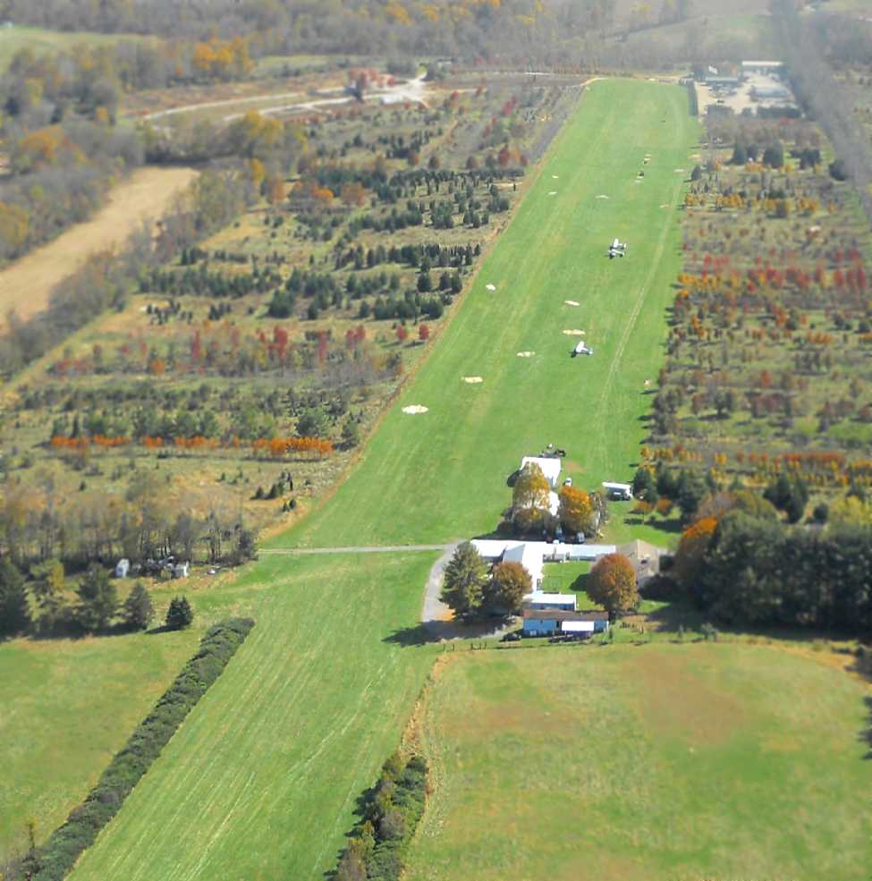
A 8/30/10 aerial view looking west at Haysfield, with 11 light single-engine aircraft visible on the field.
In 2010, the FAA Airport/Facility Directory data for Haysfield described the field as having a single 2,400' turf Runway 13/31,
and said a total of 27 aircraft were based at the field.
The owner & manager were listed as Alfred Bassler.
In 2010, reportedly the owner of Haysfield was referring to the “projected closure” of the field.
In 2010, Kim Trout reported, “There are about 10 of us who have planes at Hays & fly actively (multiple times a week / month)
plus the PUGAIR rental 172.
A very nice quite airport like flying used to be (except for the SFRA of course).
I expect it will be around for a few years after the recession ends.
But the land has been sold & the bulldozer will eventually come through.”
As of 2010, Haysfield was one of only 2 remaining grass airfields within the 15 NM Class B ring of Baltimore airspace.
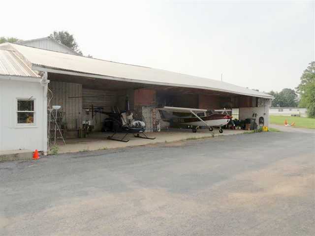
An undated (pre-2012) photo of a Robinson R-22 & a Cessna 172 inside a Haysfield hangar.
Robert Schapiro reported in 2012, “Developers have started to move in on the runway.
By the end of this month, there will likely be a paved road crossing Runway 31/13 a few hundred feet down from the threshold to Runway 31.
Some of the airplane owners have started to move their airplanes to Fort Meade,
however there are still about 9 airplanes, 2 ultra-lights, and 1 helicopter based at the field.
I operate the helicopter (www.bootcamphelicopters.com) and I’ve told Al Basler that I’ll keep paying rent until the hangar comes down – I don’t need a runway.
The airport doesn’t have fuel but if you’re good at grass strip, short-field, sloped landings, it’s a great airport to visit.
Just a 5 minute drive from the heart of Clarksville & a 15 minute drive from downtown Columbia.”
A sad October 2012 aerial view looking east at Haysfield by Tom Henry, taken on his last day at the field, before moving to W18.
Tom reported the picture shows “water wells drilled into [the] runway, for new home construction.
The field is 'useable' but the remaining planes haven't flown in years.”
Robert Schapiro reported in 2012, “I received a phone call from Al Basler on Wednesday [1/16/13]
telling me that they are dropping the 'airport insurance' & that the airport is officially closed.”
According to Jan Smith, “With the reviving economy, development plans were renewed & that was the end of the airport.”

A 1/19/13 aerial view by Robert Schapiro looking southwest at Haysfield, on the sad occasion of the last flight out of Haysfield.
Robert reported, “I moved the helicopter out yesterday, as the last remaining airworthy aircraft
(there are still a few unairworthy aircraft sitting on the grass).
You’ll notice that they planted pine trees across the runway…
that was done this past week, I think as a way of telling the rest of us, 'It’s time to go.'”
A 2014 aerial view showed houses covering the site of Haysfield,
thus closing the chapter of Howard County aviation, leaving the county with not a single public-use airport.
____________________________________________________
Columbia Airfield, Columbia, MD
39.24 North / 76.84 West (Southwest of Baltimore, MD)

"Landing Strip", as depicted on the 1949 USGS topo map.
Photo of the airfield while in use has not been located.
Not much is known about this small former airfield,
including its actual name, its date of construction, or its date of abandonment.
The only depiction of this airfield which has been located was on the 1949 USGS topo map.
It depicted a single 1,600' runway, labeled simply as "Landing Strip".
No airfield at this location was depicted on aeronautical charts from 1940-66
(but this airfield may simply have been overlooked, as a relatively minor private airfield).
Beaverbrook resident Jason Ludicke reported, “The mail carrier that delivered mail in this neighborhood for 30 years
told me it was the farmer’s airfield & that the farmer had a plane.
This was also confirmed by my neighbor whose father was one of the original builders in this neighborhood (last name Pistorio).”
Joe Zamoyta reported, “I’ve discovered guys who know all about it & have landed there.
The field was private & owned by Al Basler, who now owns Hays Field Airport, also in Columbia.
The story goes he outfoxed Rouse [James Rouse, developer of Columbia], who tried to steal his land.”
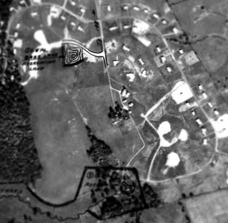
A 1963 aerial photo showing the neighborhood of Beaverbook under construction.
The area of the former airfield appears to be newly-graded, with no trace remaining.
By the 1960s, the entire area around this former airfield was developed into the City of Columbia,
a large planned community.
The site of the former airfield became the Beaverbrook residential development.
The 1974 USGS aerial photo showed that the site of the former Columbia Airfield had been replaced with suburban streets.
The 1993 USGS aerial photo showed that the site of the former Columbia Airfield had been densely filled with suburban housing,
and not a trace appeared to remain of the former airfield.

As seen in the 2002 USGS aerial photo, not a trace appears to remain of the former airfield.
According to Beaverbrook resident Jason Ludicke, “The airfield was exactly where Darlington Road is today.”
____________________________________________________
Turf Valley Airfield, Ellicott City,MD
39.3 North / 76.89 West (West of Baltimore, MD)
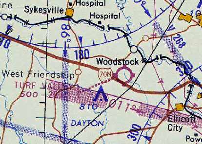
Turf Valley Airfield, as depicted on the February 1962 Washington Sectional Chart (courtesy of Chris Kennedy).
Most suburban golfers who play on the course of the Turf Valley County Club
are probably unaware that the club used to have its own private airfield for the use of members.
=
The Turf Valley Airfield was apparently built at some point between 1961-62,
as it was not depicted on the 1953 USGS topo map, a 1957 aerial photo,
nor on the 1961 Washington Local Aeronautical Chart (courtesy of Mike Keefe).
The earliest depiction of the airfield which has been located
was on the February 1962 Washington Sectional Chart (courtesy of Chris Kennedy),
which described Turf Valley Airfield as a 2,000' unpaved runway.
Joe Zamoyta recalled, “My logbooks indicate that I flew from Turf Valley Airport from 6/15/63 to 12/7/63.
I received my twin instruction in my Piper Apache N1163P there from Ed Roggero,
who was chief instructor there for Fran Dane, who operated the field for Sam Pistorio,
a local contractor who built what was then Turf Valley Golf Course.
Fran & Ed had come over from Mrs. McNemar’s United Flying Service,
who operated Frederick Municipal Airport after Rutherford Field closed.
Turf Valley field was rough, rough, rough.
It was composed of 3 parallel levels. On top was the trailer office.
The runway was below that & there was a parallel taxiway farther down the hillside.”
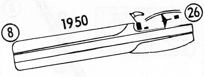
The 1963 Washington Local Aeronautical Chart (courtesy of Mike Keefe)
described Turf Valley Airfield as having a single 1,950' runway (turf, of course!).

The earliest photo which has been located showing the Turf Valley Airport was a 1963 aerial photo looking west (courtesy of Tina Kloss).
Tina reported, “I am the great niece of Samuel Pistorio who was the original owner/architect of the Turf Valley Country Club.
You can see the runway which I have highlighted in yellow.”

Turf Valley Airfield, as depicted on the 1964 Washington Sectional Chart (courtesy of John Voss).
The 1965 Washington Local Visual Navigation Chart depicted Turf Valley
as having a 1,900' unpaved runway.
Pilot John Gruver moved to Turf Valley in 1965.
He recalled, "The runway was over the hill about a half mile due west of the clubhouse,
where it flattens out between the barns.
There is a maintenance shack along were it was that is still there.
It ran northeast/southwest. I remember planes landing there as a child."

The last photo which is available showing the Turf Valley runway was a 2/21/66 USGS aerial view.
It depicted a single grass northeast/southwest runway on the northwest side of the golf course,
which was marked with 2 closed-runway “X” symbols on the southwest end,
presumably to discourage uninvited drop-in visitors.
The last aeronautical chart depiction which has been located of Turf Valley Airfield
was on the 1967 Washington Sectional Chart (courtesy of John Voss).
The last airport directory listing which has been located of Turf Valley Airfield
was in the 1968 Flight Guide (courtesy of Bob Levittan),
which depicted Turf Valley as having a 1,950' unpaved Runway 8/26,
with 3 small buildings on the northeast side.
According to John Gruver, "The last plane I remember [at Turf Valley] was around 1969."
According to Tina Kloss (great niece of Samuel Pistorio), “My husband was an assistant pro at Turf Valley in the late 1960s
and he told me that there was a problem with one of the planes landing there at that time
that may have caused the airport to close.”
Joe Zamoyta recalled, “[Fran] Dane & [Sam] Pistorio didn’t get along very well
so the field closed and eventually became part of the golf course.”
Turf Valley Airfield was apparently closed by 1970,
as it was no longer depicted at all on the 1970 Washington Sectional Chart (courtesy of John Clifford).
A 1971 aerial view still showed the cleared area of a ENE/WSW runway,
but there was no sign of any recent aviation use.
The 1979 USGS topo map did not depict any airfield at Turf Valley.

In this circa 2001 aerial photo, although the golf course now surrounds the site of the former airfield,
what appears to be the outline of the northeast/southwest runway is still visible on the northwest side of the golf course.
The site of the Turf Valley Airfield is located northwest of the intersection of Route 40 & Turf Valley Road.
____________________________________________________
Since this site was first put on the web in 1999, its popularity has grown tremendously.
That has caused it to often exceed bandwidth limitations
set by the company which I pay to host it on the web.
If the total quantity of material on this site is to continue to grow,
it will require ever-increasing funding to pay its expenses.
Therefore, I request financial contributions from site visitors,
to help defray the increasing costs of the site
and ensure that it continues to be available & to grow.
What would you pay for a good aviation magazine, or a good aviation book?
Please consider a donation of an equivalent amount, at the least.
This site is not supported by commercial advertising –
it is purely supported by donations.
If you enjoy the site, and would like to make a financial contribution,
you
may use a credit card via
![]() ,
using one of 2 methods:
,
using one of 2 methods:
To make a one-time donation of an amount of your choice:
Or you can sign up for a $10 monthly subscription to help support the site on an ongoing basis:
Or if you prefer to contact me directly concerning a contribution (for a mailing address to send a check),
please contact me at: paulandterryfreeman@gmail.com
If you enjoy this web site, please support it with a financial contribution.
please contact me at: paulandterryfreeman@gmail.com
If you enjoy this web site, please support it with a financial contribution.
____________________________________________________
This site covers airfields in all 50 states.
For the site's main menu: Home