Abandoned & Little-Known Airfields:
Michigan: Southern Detroit Area
© 2002, © 2016 by Paul Freeman. Revised 4/30/16.
This site covers airfields in all 50 states: Click here for the site's main menu.
____________________________________________________
Please consider a financial contribution to support the continued growth & operation of this site.
Haggerty Field / Detroit Aviation Testing Field (revised 11/12/13) - Hance Airport (revised 4/2/16)
National Airways Airport / National Air Service Airport / National Airport (revised 1/8/15) - Newport NOLF (revised 3/1/16)
Sheep Ranch NOLF (revised 3/1/16) - Smith Airport / Hartsell Air Terminal / National Airport (revised 4/30/16) - Stinson Factory Airfield (revised 1/19/13)
____________________________________________________
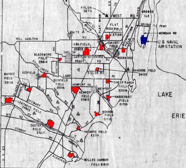
Sheep Ranch Naval Outer Landing Field, Newport, MI
42.02 North / 83.27 West (Southwest of Detroit, MI)
A 1942 map (courtesy of the NAS Grosse Ile web site) depicting "Sheepranch Field 22508"
as well as other Grosse Ile auxiliary airfields.
This field was built during the WW2 era as one of the 16 satellite landing fields
which supported primary flight training at Grosse Ile Naval Air Station.
The date of construction of Sheep Ranch NOLF has not been determined,
but the earliest depiction of the field which has been located
was a 1942 map (courtesy of the NAS Grosse Ile web site), which depicted “Sheep Ranch Field 22508" as a rectangular outline.

Sheep Ranch Field 22508, as depicted on an October 1943 map of NAS Grosse Ile & its Outlying Fields (from the National Archives, courtesy of Brian Rehwinkel).

The earliest photo which has been located of Sheep Ranch Field was a 2/18/44 U.S. Navy aerial view looking south (from the National Archives, courtesy of Brian Rehwinkel).
It depicted Sheep Ranch as having a 1,000' diameter circular paved landing mat in the middle of a square grass field.
There were a few small buildings on the periphery, but none appeared to be directly related to the airfield.
Brian Rehwinkel reported, “According to a 1944 Outlying Field Report for NAS Grosse Ile, the [Sheep Ranch] mat was 1,000’ in diameter (bituminous/macadam material).
The Navy’s training focused on landing on a spot - hence the landing circles seen on many of their training fields in WWII -
so the shorter fields were probably just used for touch & go most of the time.
I believe this field was originally a sod field, and the hard surfaced mats were added so the fields could be used all year round - dry & wet seasons.
This airfield was just over 154 acres. The field’s numeric designation was #22508.”
This designation meant that the field was located 08 miles along a 225 degree radial from the parent field (NAS Grosse Ile).

A 1944 U.S. Navy aerial view of Sheep Ranch Field (from the National Archives, courtesy of Brian Rehwinkel).

The earliest aeronautical chart depiction which has been located of the Sheep Ranch airfield
was on the June 1945 Detroit Sectional Chart (courtesy of Dick Merrill).
It depicted "Sheep Ranch (Navy)" as an auxiliary airfield.

A 1947 Army Corps of Engineers map (courtesy of Mike Denja) showed the "Sheep Ranch (Navy)" airfield
in relation to its parent airfield, NAS Grosse Ile.

The last aeronautical chart depiction which has been located of the Sheep Ranch airfield was on the July 1947 Cleveland Sectional Chart.
It depicted "Sheep Ranch (Navy)" as an auxiliary airfield.
Sheep Ranch Field was evidently closed at some point between 1947-49,
as it was no longer depicted on the 1949 Detroit Sectional Chart (courtesy of Donald Felton).
A 1949 aerial view (courtesy of Mike Denja) showed Sheep Ranch Field to remain intact, but without any indication of recent aviation use.

A 6/1/51 aerial view (courtesy of Mike Denja) showed Sheep Ranch Field to remain intact, but without any indication of recent aviation use.

The last photo which has been located of Sheep Ranch Field was a 1956 aerial view (courtesy of Mike Denja), also showing its proximity to Newport OLF.
It showed the circular landing mat of Sheep Ranch Field to remain recognizable, but with significant portions of the pavement having been removed.

A 2010 aerial view of the site of Sheep Ranch Field (courtesy of Brian Rehwinkel).
Brian Rehwinkel observed, “Amazingly, you can still see the outline of the landing mat all these years later.”
The site of Sheep Ranch Feld is located southwest of the intersection of Labo Road & North Dixie Highway.
Thanks to Mike Denja for pointing out this airfield.
____________________________________________________
National Airways Airport / National Air Service Airport / National Airport, Livonia, MI
42.37 North / 83.34 West (Southwest of Detroit, MI)

National Air Service Airport, as depicted on the 1936 USGS topo map (courtesy of Mike Denja).
The National Airways Airport on the southwest corner of Plymouth Road & Middlebelt Road was reportedly established in 1916.
The earliest depiction which has been located of National Air Service Airport was on the 1936 USGS topo map (courtesy of Mike Denja).
It depicted National Air Service Airport as an L-shaped property outline with 2 small buildings on the north side.

A 1936 plat map (courtesy of Mike Denja) depicted National Airways Airport as an L-shaped property outline.

A circa 1930s photo (courtesy of Mike Denja) depicted 2 unidentified pilots in front of 3 biplanes (model undetermined) & a hangar at National Airways Airport.

The 1942 USGS topo map (courtesy of Mike Denja) depicted National Air Service Airport in the same fashion as the 1936 topo map.

The 1947 MI Airport Directory (courtesy of Mike Denja) depicted “National Airport” as having 2 sod runways,
measuring 3,000' northwest/southeast & 2,900' northeast/southwest, each of which had irregularly-shaped portions “stabilized with gravel & asphalt”.
Three hangars were depicted along the north side.

The earliest photo which has been located of National Air Service Airport was a 1949 aerial view (courtesy of Mike Denja).
It depicted the field as having 2 sod runways, with 6 single-engine aircraft & 3 small hangars on the north side.
National Air Service Airport was presumably closed at some point between 1949-51,
as a 6/1/51 USGS aerial photo (courtesy of Mike Denja) showed buses parked on the runways.
The airport was otherwise intact, but devoid of aircraft.
A huge Ford parts distribution center / warehouse had been built directly across Plymouth Road to the north,
which undoubtedly made the little airport property too commercially valuable to continue as an airport.

A 9/12/51 aerial view looking northeast at National Air Service Airport (courtesy of Mike Denja) depicted dozens of buses parked on the airfield around the hangars, in place of aircraft.
The brand-new Ford warehouse was visible directly across Plymouth Road.

A 6/14/52 photo looking southwest at the formal dedication of the Ford parts distribution center / warehouse
across the street from National Air Service Airport (courtesy of Mike Denja),
showing cars parked on the airfield behind the hangar.

The last photo which has been located of National Air Service Airport was a 1952 aerial view (courtesy of Mike Denja).
The airport remained intact but was devoid of aircraft, in contrast to the 1949 photo.
According to Mike Denja, National Air Service Airport “became the site of Wonderland Mall in 1958.”
A 2000 aerial photo showed that the site of National Air Service Airport had been covered by a shopping center.

A 2010 aerial photo showed no trace remaining of National Air Service Airport.
The site of National Air Service Airport is located southwest of the intersection of Plymouth Road & Middlebelt Road.
Thanks to Mike Denja for pointing out this airfield.
____________________________________________________
42.22, -83.2 (South of Detroit, MI)

A 1930 photo of an unidentified person in front of an unidentified biplane at Hance Airport (courtesy of Mike Denja).
The date of establishment of this small general aviation airport has not been determined.
The earliest depiction which has been located of Hance Airport
was a 1930 photo of an unidentified person in front of an unidentified biplane (courtesy of Mike Denja).
However, Hance Airport was not yet depicted on the 1936 USGS topo map (according to Mike Denja).
According to Julie Ownby, “I am the great-granddaughter of Joseph Hance, owner of the Hance Flying Service in Wyandotte.
My grandpa said that his father, Joseph Hance, opened the airport between 1938-40. He leased the property & owned the buildings.”

The earliest aeronautical chart depiction which has been located of Hance Airport
was on the October 1942 Detroit Sectional Chart.
It depicted Hance as an auxiliary airfield.
David Warren reported, “I saw a 2-line ad that advertised Hance Flying Service using a Wyandotte address.”

A circa 1943 photo (courtesy of Julie Ownby), which Julie reported “is my grandfather, Joseph Hance, and his future wife, Rosemary Chateau”, in front of a Piper Cub at Hance Airport.
Julie reported, “Joseph's father owned the Hance Flying Service, also named Joseph Hance.”

A circa 1943 photo (courtesy of Julie Ownby) at Hance Airport, which Julie reported showed “Joseph Hance (owner), his wife Helen Hance, and their son (my grandpa) Joseph Hance.”
According to Jeanie Merckel, the 1943 airports in her father's (Henry Cuthbert) pilot logbook included Hance.

The earliest aerial photo which has been located of Hance Airport
was a 9/12/43 aerial view looking north from the 1945 AAF Airfield Directory (courtesy of Scott Murdock).
It depicted Hance as having 3 unpaved runways with a ramp on the north side.
The 1945 AAF Airfield Directory (courtesy of Scott Murdock) described Hance Airport
as a 160 acre square-shaped property having 3 clay, loam, and sod runways, the longest being the 3,300' northeast/southwest strip.
The field was said to have 2 hangars, the largest being a 177' x 30' wood structure,
and the field was described as being owned & operated by private interests.

A circa mid-1940s photo (courtesy of Julie Ownby) of Joseph Hance, owner of Hance Airport, in the middle in the leather jacket, along with others in front of an unidentified biplane & a Hance Airport hangar.

A photo by Julie Ownby of the circa mid-1940s Hance Flying Service logo.

The 1947 MI Airport Directory (courtesy of Mike Denja) depicted Hance Airport as having 3 graded runways, with the longest being the 3,300' northeast/southwest strip.

A 1949 aerial photo (courtesy of Mike Denja) depicted Hance Airport at perhaps the zenith of its popularity,
with 22 light aircraft visible parked on the north side of the field near the hangar.

The last aeronautical chart depiction which has been located of Hance Airport was on the 1949 Detroit Sectional Chart.
It depicted Hance as having a 2,600' unpaved runway.

The 1952 USGS topo map misspelled the name as “Hange Airport”.
It depicted the field as having 3 unpaved runways, with a ramp & some small buildings on the north side.

The last photo which has been located of Hance Airport was a 1952 aerial view (courtesy of Mike Denja).
It depicted 10 light aircraft on the north side of the field.
According to Julie Ownby, “My grandpa said that the airport closed around 1952.”

The last depiction which has been located of Hance Airport was on the 1954 USGS topo map (courtesy of Mike Denja).
According to Mike Denja, Hance Airport “appears to be gone around 1955/56.”
The 1967 USGS topo map depicted residential streets covering the site of Hance Airport.

A 5/9/10 aerial view showed houses covering the site of Hance Airport, with no trace remaining of the little airport.
The site of Hance Airport is located southwest of the intersection of Eureka Road & Trenton Road.
Thanks to Mike Denja for pointing out this airfield.
____________________________________________________
Haggerty Field / Detroit Aviation Testing Field, Dearborn, MI
42.33 North / 83.16 West (Southwest of Detroit, MI)

A 1935 street map depicted Haggerty Field as an L-shaped property.
According to Dick Soules, “At the beginning of the 20th Century the family of John Haggerty owned a large portion
of land on the outside of Dearborn bordering on Detroit at Wyoming Avenue.
They were well known as brick manufacturers & utilized part of the property for brick making.
It was the dawn of the automobile & new makes came & went.
One of these was the Rickenbacker automobile.
Named after the famous WW1 fighter ace.
The factory was built on Michigan Avenue near the Haggerty Field area.”
Dick continued, “In 1920 Eddie Rickenbacker requested permission to use some of the open land on the northeast side as an airstrip.
It became known as Haggerty Field.
After the Rickenbacker Company closed in 1927
the field was used by a flying club called The Wise Birds & offered rides for 50 cents.”
According to the Dearborn Historian (courtesy of Karen Wisniewski),
“The field was formally dedicated as Haggerty Airport 4/10/30.
The field was also referred to at one time as Detroit Aviation Testing Field.”
Haggerty Field was not yet depicted on the 1934 USGS topo map or the June 1931 Detroit Sectional Chart.
The earliest depiction which has been located of Haggerty Field was a 1935 street map,
which depicted Haggerty Field as an L-shaped property.

The earliest photo which has been located of Haggerty Field was a 1936 aerial view looking northwest,
showing an open grass field across the street from the massive De Soto automobile factory.
No aircraft or hangars were visible on the portion of the airfield visible in the photo.

An undated artist's conception looking northeast at Haggerty Field (courtesy of Dick Soules), with the massive De Soto automobile factory across the street.
The runways, taxiways, and hangars depicted at Haggerty Field may have been more extensive than what was built in reality.

A 1936 street map (courtesy of the Dearborn Historical Society, via Dick Soules) depicted Haggerty Field as a rectangular plot labeled as “Flying Field”,
with a single small building on the southeast corner.

A 1936 photo of a building with “Haggerty Field” painted on the roof (courtesy of the Dearborn Historical Society, via Dick Soules).

An undated street map (courtesy of Greg Steinmayer) showing the location of Haggerty Field, along with Morrow Field to the north.

The earliest aeronautical chart depiction which has been located of Haggerty Field
was on the February 1937 Detroit Sectional Chart (courtesy of Chris Kennedy).
It depicted Haggerty as a commercial/municipal airport.

The last photo which has been located still showing Haggerty Field presumably in operation was a 1941 aerial view
(courtesy of the Dearborn Historical Society, via Dick Soules).
It showed a grass field, with a few small buildings along the east & south sides.
No aircraft were visible on the field.
According to Dick Soules, “It was used by amateur pilots right up to the start of WW2.”

The 1942 USGS topo map depicted Haggerty Field as an L-shaped outline.
No buildings or other airport features were depicted.

The last aeronautical chart depiction which has been located of Haggerty Field
was on the October 1942 Detroit Sectional Chart.
According to Dick Soules, “The commercial demand of the land
became the primary factor in the disappearing grass airstrip known as Haggerty Field.”
Haggerty Field was evidently closed at some point between 1942-45,
as it was no longer depicted on the May 1945 Detroit Sectional Chart.
According to Dick Soules, “In 1948 a portion of the land was sold to build The Ford Wyoming Theater, a drive-in.”
The 1952 USGS topo map depicted several buildings & storage tanks having been constructed over the site of Haggerty Field.
A 1955 aerial photo (courtesy of the Dearborn Historical Society, via Dick Soules)
showed the drive-in movie theater on the southwest portion of the Haggerty Field site.

A 5/9/10 aerial view showed the Haggerty Field site covered by a multi-screen drive-in movie theater, small buildings, and storage tanks.
The site of Haggerty Field is located northwest of the intersection of Ford Road & Wyoming Avenue.
____________________________________________________
Stinson Factory Airfield, Wayne, MI
42.26 North / 83.4 West (Southwest of Detroit, MI)

A 1930s commercial atlas drawing of the Stinson Wayne Factory.
A “Service Building” is depicted on the south side,
and a 6' chain-link fence surrounds the buildings, outside of which on the north & west sides is a “Landing Field”.
The Stinson Aircraft Company had operated in several Detroit-area facilities since 1919,
manufacturing small general aviation aircraft.
Newspaper reports indicated that construction of Stinson's new factory in Wayne were under way in early December of 1928,
with hopes that it would be completed by January of 1929.
The Stinson Aircraft Corporation relocated from Northville MI to Wayne in 1929,
with the completion of their new factory.
Automobile mogul Errett Cord acquired 60% of Stinson's stock in September 1929,
and his Cord Corporation provided additional investment capital to permit Stinson to sell its aircraft at a competitive price while still pursuing new designs.
At the height of the Depression in 1930, Stinson offered 6 aircraft models, ranging from the 4-seat Junior to the Stinson 6000 trimotor airliner.
The Stinson Aircraft Corporation merged with E.L. Cord Corporation in 1931.
The earliest depiction which has been located of the Stinson Wayne factory & airfield
was a 1930s commercial atlas drawing of the Stinson Wayne Factory.
It depicted a large factory & a smaller “Service Building” surrounded by a 6' chain-link fence,
outside of which on the north & west sides was a “Landing Field”.
Eddie Stinson did not live to enjoy the success of his company.
He died in an air crash in Chicago on January 26, 1932, while on a sales trip.
At the time of his death at age 38, Stinson had acquired more than 16,000 hours of flight time - more than any other pilot at the time.
Eddie Stinson's death accelerated the assimilation of Stinson Aircraft Corporation into larger corporate entities.

The earliest photo which has been located of the Stinson Wayne factory
was 1932-33 photo of a Stinson Model M, NR12123, inside the Wayne factory.

The earliest photo which has been located of the Stinson Wayne airfield
was a 1934 photo of a 3-engine Stinon A in front of a hangar labeled “Stinson Aircraft Company”.

The earliest topo map depiction which has been located of the Stinson Factory Airfield was on the 1936 USGS topo map.
It depicted the outline of the Stinson Factory Airfield, with the factory on the east side, but inexplicably did not label any of it.

The earliest aeronautical chart depiction which has been located of the Stinson Factory Airfield
was on the February 1937 Detroit Sectional Chart (courtesy of Chris Kennedy).
It depicted Stinson as a commercial/municipal airport.
In 1940, Stinson became the Stinson Aircraft Division of Vultee-AVCO.

The 1940 MI Airport Directory (courtesy of Chris Kennedy)
depicted the “Wayne-Stinson” factory & a smaller building on the east side,
with a 2,000' sandy north/south runway & 2,000' cinder east/west runway.
According to Sean Mullaly, “The book Stinson Aircraft Company by John Bluth, page 76
shows an early drawing of the Detroit-Wayne Industrial Airport (Stinson) with 4 sod runways intersecting in the 'swamp' area.”

The earliest photo which has been located of the Stinson plant was a 3/6/41 interior view of Stinson 10As on the Stinson assembly line.
When Consolidated & Vultee merged in 1943, Stinson then became a division of the new company.

The earliest photo which has been located of the Stinson Factory Airfield
was a 9/10/43 aerial view looking north from the 1945 AAF Airfield Directory (courtesy of Scott Murdock).
It depicted the “Stinson Aircraft Field” as having 2 runways, with the factory on the east side.
The 1945 AAF Airfield Directory (courtesy of Scott Murdock) described the “Stinson Aircraft Field”
as a 173 acre irregularly-shaped property having 2 concrete runways, the longest being the 2,500' NNE/SSW strip.
The field was said to have 2 hangars, the largest being a 125' x 115' concrete block structure,
and the field was described as being owned & operated by private interests.
The Wayne facility of Consolidated-Vultee Aircraft produced a total of 500 AT-19 trainers & 3,590 L-5 liaison aircraft during WW2,
with the plant having the USAAF code of “VW”.
In 1946 Stinson became the Stinson Aircraft Division of Convair.

The 1946 MI Airport Directory (courtesy of Doug Ranz)
depicted the Stinson Factory Airfield as having been significantly expanded at some point between 1940-46,
with 2 concrete runways (the longest being the 2,500' northeast/southwest strip).
The factory & 2 hangars were depicted on the east side of the airfield.
According to Sean Mullaly, “The photo in Fly It Away by Henry Lent on page 97 shows a much more evolved airport
with 2 hard-surfaced runways in entirely different locations on the same property (the railroad never moves).”

A late September / early October 1947 photo of the Wayne Stinson Factory building Stionson 108-3 Flying Station Wagons.
NC578C is shown on the production line, with 4 other 108-3s in various stages of construction.
In 1948, the Stinson Division was sold to the Piper Aircraft Company in Lock Haven PA,
which continued to produce Stinson 108s for a limited time.
Piper also transformed an original Stinson design (the "Twin Stinson") into the successful Piper Apache,
the world's first general aviation all-metal twin-engine modern aircraft.
The 1948 USGS topo map depicted the Stinson Factory Airfield in the same fashion as depicted on the 1936 USGS topo map,
with an outline of the airfield & the factory on the east side, but inexplicably did not label any of it.

The last aeronautical chart depiction which has been located of the Stinson Factory Airfield
was on the 1949 Detroit Sectional Chart (courtesy of Donald Felton).
It depicted Stinson as having a 2,500' paved runway.

A 1949 aerial view of the Stinson Factory Airfield (from Wayne State University)
showed it to consist of 2 concrete runways, with a ramp, factory, and 2 hangars on the east side.

A closeup from the 1949 aerial view of the Stinson Factory Airfield (from Wayne State University)
showed 5 light aircraft parked around the hangars, and the name “Stinson” painted on the roof of the building on the west side of the factory.

The 1949 USGS topo map misspelled the name as “Stimsom”, and depicted it as a private airfield.
According to Sean Mullaly, Piper continued production in the Stinson Wayne factory for a year after acquiring it,
until they canceled the 108 series in 1949.

A 7/9/52 aerial view of the Stinson Factory Airfield (from Wayne State University)
no longer showed any planes on the field, and instead showed cars parked on the northeast/southwest runway,
so it is possible the airfield may have been closed by that point.
The 1952 USGS topo map depicted 2 paved runways on the west side of the Stinson factory, but without any labels.
The 1954 USGS topo map continued to label the misspelled “Stimsom” as a private airfield.
The Stinson Airfield was no longer depicted on the May 1958 Detroit Sectional Chart.
The 1961 USGS topo map no longer depicted the Stinson Airfield.
In 1962 the inventory & rights of the Stinson Division were sold by Piper to Univair, Aurora CO.
A 1964 aerial view showed the Stinson factory & airfield to remain basically unchanged.

The 1964 Detroit Sectional Chart (courtesy of John De Nicola) depicted Stinson as “Abandoned airport”.

A 5/3/67 aerial view of the Stinson Factory Airfield (from Wayne State University)
showed that the southeastern hangar had been replaced with an expansion of the main factory building.
The airfield otherwise remained intact, with cars parked on the northeast/southwest runway.
The 1970 USGS topo map no longer depicted any airfield at the site of the Stinson Factory.
A 1973 aerial view showed that at some point between 1964-73 portions of the northeast/southwest runway
had been covered by an expansion on the parking lot (over the middle of the runway)
and an expansion of the factory building (over the southwestern end of the runway).
The northwest/southeast runway remained intact.
As of 1976, the former Stinson Factory may have become part of the GM Romulus engine/transmission plant.
The 1999 USGS aerial photo showed an unusual northeast/southwest-oriented strip of pavement which had been added at some point between 1973-99,
but this was not related to the former airfield,
as it was located a few hundred feet farther to the west from the location of the former northeast/southwest runway,
had a different orientation, and was much shorter.

An 8/17/07 aerial view showed that a portion of the circa-1928 Stinson Aircraft factory may remain (the white-roofed building),
but mostly covered by more modern buildings.
No trace appears to remain of the former runways.

A circa 2007 aerial view looking south at what appears to be the circa-1928 Stinson Aircraft factory.

Two 2009 photos (by Gil Wilcox, courtesy of Sean Mullaly) of the former Stinson Aircraft Factory.
Sean reported, “Much of that structure is still identifiable today.
You can find where that water tower stood (but no longer there).
The white-roofed building is what is left of the original building.
The others were built around it after the factory closed.”
As of 2010, street maps label the former Stinson Factory as the “GM Powertrain facility”.
The site of the Stinson Factory Airfield is located southwest of the intersection of Van Born Road & Wayne Road.
____________________________________________________
Smith Airport / Hartsell Air Terminal / National Airport (1G2), Westland, MI
42.32, -83.43 (Southwest of Detroit, MI)

Smith Airport, as depicted in the May 1945 Detroit Sectional Chart (courtesy of Chris Kennedy).
This general aviation airport was evidently established at some point between 1944-45
(like hundreds of other small airports across the U.S.),
as it was not yet depicted on the October 1944 Detroit Sectional Chart (according to Chris Kennedy).
The earliest depiction of Smith Airport which has been located
was on the May 1945 Detroit Sectional Chart (courtesy of Chris Kennedy).
It depicted Smith as a commercial/municipal airport.
The Haire Publishing Company's 1945 Airport Directory (courtesy of Chris Kennedy)
described Smith Airport as a “class 1” privately-owned field
consisting of 3 sod runways, with the longest being the 2,400' northwest/southeast strip.
The 1945 AAF Airfield Directory (courtesy of Scott Murdock) described Smith Field
as an 88 acre irregularly-shaped property having 3 turf runways, the longest being the 2,400' northwest/southeast strip.
The field was not said to have any hangars, and to be owned & operated by private interests.
The airport was apparently renamed Hartsell Air Terminal at some point between 1945-46,
as it was labeled “Hartsell” on the July 1946 Detroit Sectional Chart (courtesy of Chris Kennedy).

The location & airfield layout of the Hartsell Air Terminal,
as depicted in the 1946 MI Airport Directory (courtesy of Doug Ranz).
The directory depicted the field as having 3 unpaved runways, with the longest being the 2,400' northwest/southeast strip.
A hangar & an office building were depicted north of the runway intersection.
Hartsell Air Terminal was not depicted at all on the 1948 USGS topo map.

The 1949 Detroit Sectional Chart (courtesy of Donald Felton)
depicted Hartsell as having a 3,500' unpaved runway.

A 1949 aerial photo of Hartsell Air Terminal, from Wayne State University (courtesy of Greg Steinmayer).
The field had 2 unpaved runways (there was no evidence of the east/west runway depicted on the 1946 diagram).
However, 3 rows of T-hangars had evidently been added at some point between 1946-49.
A total of 7 light single-engine aircraft were visible parked on the field.

The earliest topo map depiction which has been located of Hartsell Airport was on the 1952 USGS topo map.
It depicted Hartsell as having 2 unpaved runways, with 4 small buildings along the northwest side.
A 1956 aerial photo from Wayne State University (courtesy of Greg Steinmayer)
showed that yet another, even longer runway had been added on the south side of the field, running due east/west.
A 3rd row of T-hangars had been removed to make way for the northwest end of the new runway.
A total of 10 light single-engine aircraft were visible parked on the field.
The airfield configuration at Hartsell continued to change further,
as a 1961 aerial photo from Wayne State University (courtesy of Greg Steinmayer)
showed that at some point between 1956-61 the field had gained a longer 3rd runway, running northwest/southeast.
The westernmost row of T-hangars was also added, just north of the original runway intersection.
However, fewer planes were visible on the field - a total of only 4 planes.
The field was evidently renamed to National Airport at some point between 1949-64,
as that is how it was labeled on the 1964 Detroit Sectional Chart (courtesy of John De Nicola).
National was depicted as having a 2,800' unpaved runway.
A 1964 aerial view showed that the field had 3 unpaved runways.
A total of a dozen light aircraft were visible on the field.

The 1967 aerial photo of National Airport from Wayne State University (courtesy of Greg Steinmayer)
showed that the east/west runway had been paved at some point between 1961-67.
It also appeared as if this had become the sole runway still in use,
as the area previously occupied by several unpaved runways was now used to park aircraft.
Yet another row of T-hangars had also been added, on the west side of the field.
The number of planes visible on the field was up sharply - to a total of 36.
The 1970 USGS topo map labeled the field as National Airport.
The last photo which has been located of National Airport was a 1973 aerial view.
The field appeared well-used, with a total of 21 light aircraft parked on the field.
Gary Bartz recalled, “I grew up near the National Airport.
I remember landings there from the mid-1970s (when I was old enough to notice).
My home was just to the northwest.
The approach to the west was fairly steep because of trees.
The runway was also much narrower than the nearby Plymouth Airport.
Some of the neighbors liked to cry about the noise even though the planes only flew during the day.”

The last aeronautical chart depiction which has been located of National Airport
was on the May 1977 Detroit Sectional Chart (courtesy of Mitchell Hymowitz).
It depicted National Airport as having a single 2,800' paved runway.

1979 Flight Guide (courtesy of Chris Kennedy)
depicted National Airport as having a single 2,800' paved Runway 9/27,
with several rows of T-hangars on the north side of the field.

The 1980 USGS topo map depicted National Airport as having a paved east/west runway & an unpaved crosswind runway,
with several small buildings on the north side of the field.
The last reference which has been located to National as an active airport
was its listing in the 1980 AOPA Airports USA Airport Directory (according to Chris Kennedy).
National Airport was evidently closed at some point between 1980-82,
as it was no longer listed among active airfields in the 1982 AOPA Airports USA Airport Directory (according to Chris Kennedy).
Gary Bartz recalled, “These were all reasons given for the closure.
I think a real reason was the railroad track to the east side of the property.
The track was/is a main line for the CSX railroad.
The other reason was that a major east/west state highway stretching from Detroit to Ann Arbor is just to the north,
and it connects to a branch of the I-75 highway system just 1 mile west of the location.
By the mid-1980s the lumber company Weyerhaeuser had a distribution center on the property,
and they used the east half of the runway for a loading ramp/driveway.
Weyerhaeuser had flown in by helicopter right as the closure was announced, and most neighbors suspected what was coming.
Helicopters almost never flew into National because the nearby Plymouth airport had full helo facilities.
Everyone noticed the Weyerhaeuser flights.”
Gary continued, “Plans and construction took a few years,
and in the meantime many of the locals used the west end of the runway as an access point to bring in 4-wheel drive trucks & bikes.
The runway made a good staging area to access the swampy creek area just to the south of the runway.
Weyerhaeuser dug a berm between the road & the runway,
and when that didn't work they finally took up the west half of the runway & redid the east.
Later a shopping center tore down the wooded area to the northwest of the runway
and built a Home Depot almost back to the runway line with way too much parking.”
National Airport was depicted as an abandoned airfield on the October 1983 Detroit Terminal Area Chart (according to Chris Kennedy).
The 1999 USGS aerial photo showed that the site of the former National Airport
had been largely covered by commercial buildings.

In the 2002 USGS aerial photo, although the site of the former National Airport was largely covered by several commercial buildings,
it appeared as though a section of runway pavement from the former east/west runway still remained intact (at the center of the photo),
along with traces of the former northwest/southeast unpaved runway.
Greg Steinmayer reported in 2006 that “The remaining part of the runway has disappeared
under a multiplex theater that has recently been built”, at some point between 2002-2006.

Remarkably, a 2006 photo by Greg Steinmayer shows that a former airport building visible in the 1949 aerial photo
still remains standing at the northeast corner of the site more nearly 60 years later,
even after almost all else of the airport has been covered over.
Greg reported that the building “has a distinctive curved 'finger' that juts out.”
It's “still standing, though somewhat worse for wear.”

A circa 2010 aerial view looking north at the former National Airport building which remains standing at the northeast corner of the site.

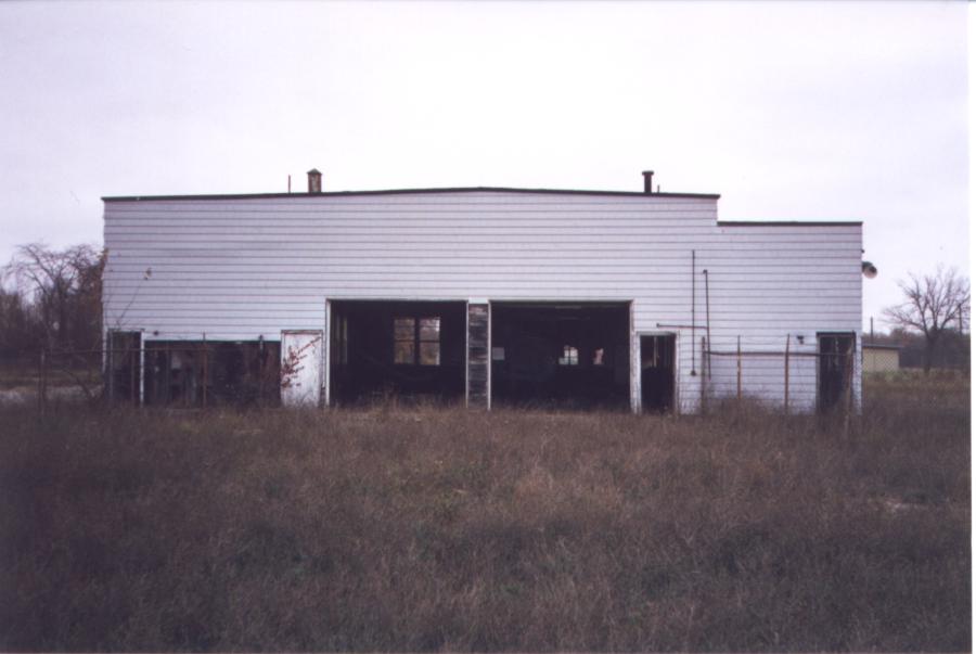
An April 2016 photo by David Schneck of the former National Airport administration building.
David observed, “The old administration building (the last remnant of the National Airport) appears to have been remodeled.”
The site of National Airport is located south of the intersection of Ford Road & Superior Parkway.
____________________________________________________
Newport Naval Outer Landing Field, Newport, MI
42 North / 83.37 West (Southwest of Detroit, MI)

A 1942 map (courtesy of the NAS Grosse Ile web site) depicting "Newport Field 23813"
as well as other Grosse Ile auxiliary airfields.
This field was built during the WW2 era as the largest of 16 satellite landing fields
which supported primary flight training at Grosse Ile Naval Air Station.
The date of construction of Newport NOLF has not been determined,
but the earliest depiction of the field which has been located
was a 1942 map (courtesy of the NAS Grosse Ile web site), which labeled it as "Newport Field "23813".

As seen in a WW2-era view of Newport (National Archives photo),
the airfield consisted of a 1,700' concrete hexagon landing pad, taxiways, a ramp, fire station & barracks.

A WW2-era view looking north at the large number of biplanes on the Newport ramp (National Archives photo).
The fire station with attached control tower was visible just above the airplanes, and the “H”-shaped barracks was visible above it.
Most of NAS Grosse Ile's cadets solo flights were conducted from Newport.
After the end of primary flight training at Grosse Ile,
Carrier Air Group 97 used Newport for Field Carrier Landing Practice.

A 2/11/1944 U.S. Navy aerial view looking west at Newport NOLF (from the National Archives, courtesy of Brian Rehwinkel),
showing the barracks, operations building, ramp, and a large number of training planes.
Brian observed, “There are a couple of other interesting things in the photo.
If you look at the right hand side of the photo (at the point where the entrance road meets the mail road), you can see 2 trucks carrying pylons on trailers.
The pylons were used as ground reference points during flight training.
Additionally, you can see an oblong shape in the foreground that resembles a hockey rink (being from Florida, I am not an expert on hockey rinks).”
The earliest aeronautical chart depiction which has been located of the Newport airfield
was on the June 1945 Detroit Sectional Chart (courtesy of Dick Merrill).
It depicted "Newport (Navy)" as an auxiliary airfield.

The 1945 AAF Airfield Directory (courtesy of Scott Murdock) described the “Grosse Ile NAS Auxiliary (23813 Newport OLF)”
as a 481 acre irregularly-shaped property having a 1,700' hexagonal concrete landing mat with a single 50' x 40' wooden hangar.
The field was said to be owned by the U.S. Government, and operated by the Navy.
A 1947 Army Corps of Engineers map (courtesy of Mike Denja) showed the "Newport (Navy)" airfield
in relation to its parent airfield, NAS Grosse Ile.
The last aeronautical chart depiction which is available of the Newport airfield was on the July 1947 Cleveland Sectional Chart.
It depicted "Newport (Navy)" as an auxiliary airfield.
"Newport (Navy)" was still depicted as a military airfield on the 1948 Detroit Sectional Chart (according to Chris Kennedy).
According to the NAS Grosse Ile website, “The Newport Field buildings were turned into a high school in 1948.”
The Newport airfield was evidently closed at some point between 1948-49,
as the airfield was not depicted at all on the 1949 Detroit Sectional Chart (courtesy of Donald Felton).

A 6/1/51 USGS aerial photo showed Newport NOLF after airfield operations had closed, but while the facility was still intact.

The 1952 USGS topo map (courtesy of Mike Denja) depicted Newport's hexagonal landing mat, labeled simply as “Landing Field”,
and the former airfield building was labeled as “Airport School”.
According to the NAS Grosse Ile website, the school housed in the Newport Field buildings “graduated the class in 1953, the last year it was used for a school.”
A 1956 aerial view (courtesy of Mike Denja) showed the proximity of Newport OLF to the nearby Sheep Ranch OLF.
Ironically, in the span of a mere 10 years,
the mission of Newport changed from training flight cadets in biplanes to shooting down Soviet nuclear bombers with supersonic guided missiles.
In the late 1950s the Newport airfield property was reused by the Army to construct 2 Nike surface-to-air missile batteries:
sites D-57 (Newport) & D-58 (Carleton).
These installations were part of the ring of Nike batteries surrounding Detroit.
Construction of the D-57 Newport & D-58 Carleton batteries began in 1957.
They were each armed with 30 of the 1st-generation Nike Ajax missiles.
The underground missile magazines & launchers were built adjacent to the south side of the Newport landing pad,
with Battery D-57's 3 rows of launchers on the north side,
and D-58's 3 rows of launchers to the south.
The barracks were built on top of the former landing pad.
The former airfield fire station was reused as a movie theater for the Nike troops.
The Integrated Fire Control areas for the 2 batteries, with numerous radar towers,
were built to the northeast of the airfield, with D-58's IFC closer to the airfield, and D-57's IFC somewhat further east.
Jim Boylan recalled, “The D57-58 Nike site... I lived there in 1958-61 as an IFC crewman in D Battery, 2nd Missile Battalion, 517th Artillery.
The building to the left as you enter the main gate was the IFC barracks.
The administration building was the large H-shaped structure to the right as you entered the main gate.
It contained the Base HQ, switchboard, rec room, base PX, and at the far end the Mess Hall.
The 2nd floor of this structure had dorm type sleeping areas for the HQ staff, and rooms for NCO's.
The theater - straight ahead from the main gate - was used for films, the chaplain's office, and large meetings or training sessions.
The old airfield area behind the theater was where everyone parked their cars.”
In June 1959, battery D-58 was converted & upgraded to fire the more capable Nike Hercules missile,
The battery was armed with 18 of the 2nd-generation Nike Hercules missiles.
Battery D-57 was not upgraded with Nike Hercules, and was deactivated in February 1963.
Battery D-58 continued to operate the Nike Hercules for several more years.

A 1964 aerial view of the Nike D-57 & D-58 launch sites, adjacent to the south side of the Newport airfield.
The above-ground Nike Ajax launchers had been removed from battery D-57 (the northern row of 3 launchers),
but the Nike Hercules launchers could be seen on Battery D-58 (the southern row of 3 launchers).

A 1973 aerial view of the remains of Newport NOLF, showing the Nike D-57 & D-58 launch sites to the southwest,
and the Nike Integrated Fire Control sites to the northeast.
The Nike Hercules D-58 IFC (closer to the airfield) was still operational (note the shadows from its large radomes),
while the Nike Ajax D-57 IFC (to the east) had been deactivated.
This was also the last photo which has been located which depicted the WW2-era “H”-shaped airfield barracks still standing on the north side of the airfield.
Nike Battery D-58 was deactivated in April 1974,
bringing an end to the military's usage of the Newport site.

A 1996 Army Corps of Engineers photo of a Nike missile silo being demolished at Newport.
Most of the buildings of the Nike installation still remain, but have decayed considerably.


A 1998 photo of the drive-through Nike Warhead Assembly Building at Newport.

An undated recent aerial view by Dick Merrill looking north at the remains of NOLF Newport.
The former “H”-shaped airfield barracks buildings at the north end of the site had been removed at some point between 1973-2000,
but the former fire station / control tower building remained standing, on the northeast side of the airfield.

A circa 2001 aerial photo, with the Nike launch site at the bottom.

A 2007 photo by Jeff Kroll looking at the Newport Nike site from “from the main gate,
with the Administration Building on left, Theater ahead; the blue thing is a shipping container.
When I was even with the shipping container 3 deer jumped out in front of me.”
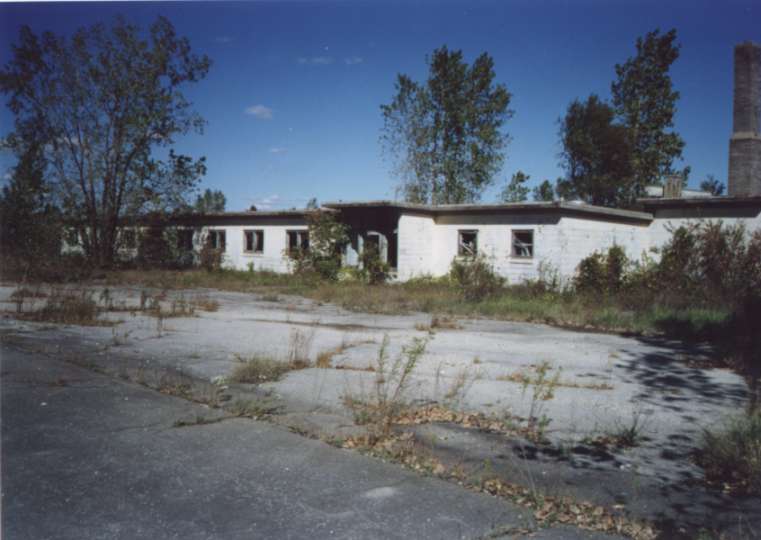
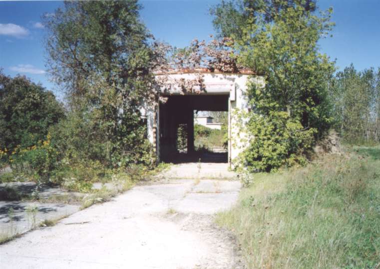
Jeff Kroll visited the site of the Newport Naval Outer Landing Field in 2007.
He reported, “The site is much more overgrown than in the 1998 photos,
almost the entire concrete landing field for the old airbase is completely overgrown,
and is now relatively heavy forest, what concrete remains exposed has broken down into gravel.
All the buildings that were there in 1998 are still there now,
but the vandals are really starting to take there toll,
and the vegetation in the launcher area is so heavy it's disorienting it's like walking through a jungle,
it took me a good 15 minutes or so to find the launcher pit area, and I was standing right at the warhead building.
The warhead building is almost entirely obscured by trees,
and the Nike generator building while visible is so overgrown you would almost need a machete to get inside.
Several of the buildings are pockmarked by bullets, and I ran across a shotgun husk,
the missile test, and assembly building has been hit hardest by the vandals,
but the whole luncher area has been hit pretty hard, and they've smashed all the windows in the Administration building,
knocked down a lightpole outside, and they're tearing down the ceiling - it's really sad to see the damage there doing there.”

A 2007 photo by Jeff Kroll of the interior of the Administration Building.
Jeff remarked, “I think this may have been made into a messhall.
Also note the Nike Insignia at the far end of the room.”

A 2007 photo by Jeff Kroll “of the Warhead Building, note how much more overgrown it is now than in the 1998 photo,
the whole area around the Nike section is completely overgrown, it's like a jungle back there.
Even though this is right next to the Launcher area, it took me a good 15 minutes to find the pathway there.
The inside of the Warhead building has been hit heavily by vandals, and one of the remaining panels has been shot up.
The lighting in this picture is interesting, it makes it look rendered, but I assure you it's quite real.”

A 2007 photo by Jeff Kroll “of what's left of the launcher pits from near the end of what I believe was D-58
looking back Towards the Warhead Building, note the metal plates on the ground.
The blast barriers are still there but there completely overgrown now.”
Jeff continued, “The area appears to be in use by local ATVers judging by the tracks,
and the one that I saw following me when I was on my way out,
and I assume it was them who knocked the southeastern corner of the fence down in the Nike area.
The whole area is teeming with wildlife now,
3 whitetail deer jumped right out in front of me by the Administration Building not even 25 yards away,
and rabbits & birds abound, the noises they make make exploring, particularly inside the buildings a little nerve racking.
The Army appears to have just up & left as the buildings were still fully-furnished,
although the vandals have done a number on the furniture,
and theres a large stack of field manuals in the Administration building, for what looks like an obsolete piece of radio equipment.
The Administration Building appears to have been converted into a barracks,
as almost all of the what I assume to have been offices had beds in them.
The site does not appear to be in use by the National Guard, or anyone else for that matter,
and the main gate was open, and there were no signs posted that said keep out, so it appears to be completely abandoned.”

A 2012 photo by Jack Strathmore (courtesy of Joe Cyster) of the interior of the Administration Building / mess hall.

A 2012 photo by Jack Strathmore (courtesy of Joe Cyster) of the Newport Nike barracks.

A 2012 photo by Jack Strathmore, according to Joe Cyster, “One of the radar towers for D-57. It was the one closest to the road.”

A 2012 photo by Jack Strathmore, according to Joe Cyster, “The fire station/theater has burnt down.
I'm not sure when it happened but the video was uploaded 11/11.”
The Newport airfield is located southwest of the intersection of Newport Road & North Telegraph Road.
____________________________________________________
Since this site was first put on the web in 1999, its popularity has grown tremendously.
That has caused it to often exceed bandwidth limitations
set by the company which I pay to host it on the web.
If the total quantity of material on this site is to continue to grow,
it will require ever-increasing funding to pay its expenses.
Therefore, I request financial contributions from site visitors,
to help defray the increasing costs of the site
and ensure that it continues to be available & to grow.
What would you pay for a good aviation magazine, or a good aviation book?
Please consider a donation of an equivalent amount, at the least.
This site is not supported by commercial advertising –
it is purely supported by donations.
If you enjoy the site, and would like to make a financial contribution,
you
may use a credit card via
![]() ,
using one of 2 methods:
,
using one of 2 methods:
To make a one-time donation of an amount of your choice:
Or you can sign up for a $10 monthly subscription to help support the site on an ongoing basis:
Or if you prefer to contact me directly concerning a contribution (for a mailing address to send a check),
please contact me at: paulandterryfreeman@gmail.com
If you enjoy this web site, please support it with a financial contribution.
please contact me at: paulandterryfreeman@gmail.com
If you enjoy this web site, please support it with a financial contribution.
____________________________________________________
This site covers airfields in all 50 states.