
Abandoned & Little-Known Airfields:
Southeastern Michigan
© 2002, © 2016 by Paul Freeman. Revised 8/23/16.
This site covers airfields in all 50 states: Click here for the site's main menu.
____________________________________________________
Please consider a financial contribution to support the continued growth & operation of this site.
Davis Airport (revised 12/1/15) - Nan Bar Airport / NOLF 27106 / Flat Rock Field (revised 8/23/16)
Washtenaw Airport / Young Airport (revised 10/25/12) - Ypsilanti Airport / Gridley Airport (revised 12/1/15)
____________________________________________________
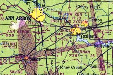
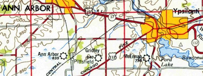
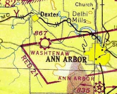
Ypsilanti Airport / Gridley Airport, Ypsilanti, MI
42.218, -83.684 (Southwest of Detroit, MI)
The cover of a program for the 1927 Air Races & Air Meet held at Ypsilanti Airport.
According to the Ypsilanti Historical Society's Winter 2008 Ypsilanti Gleanings (courtesy of Mike Denja),
“On 7/27/26 a group of 20 men interested in the possibility of an airfield near Ypsilanti listened to William Mars,
an airplane manufacturer who spoke on the general developments in aviation.
Ypsilanti, Mars pointed out, was on the biggest air route in the country - New York, Cleveland, Detroit & Chicago.
Airplane factories near Ypsilanti were 6 months behind in deliveries, he contended, and prospective buyers living in Ypsilanti would place orders if a landing field were near the city.
Within 5 years government officials expected people to fly to & from their place of employment in metropolitan areas miles apart.
Airplanes were then selling at $2,400, the cost of a medium priced automobile. All that was needed was a landing strip.”
The Ypsilanti Gleanings article continued, “Land for the airport was procured at Carpenter & Morgan Roads in Pittsfield Township, by a syndicate of 30 people.
The airport included 160 acres in a field a half mile square.
At the airport a hanger was constructed, 32' wide & 114' feet long, with room enough for 4 planes.”
“It is so arranged that each plane can be wheeled into place with a large door exactly in front of each plane,” reported The Daily Ypsilanti Press of 1/24/27.
The Ypsilanti Gleanings article continued, “The Ypsilanti City Airport was dedicated with 3 days of events at the airport on June 10-12, 1927.
Some 2,500 people watched as the program began with an aerial parade which was followed by a speed race around the field.
Planes raced that day at over 80 mph. The next day, the planes raced at speeds of over 100 mph.
Each day included a dead-stick landing contest & a parachute drop.”
“The program closed with a double parachute drop, Robert Manier & Leon Snyder leaping simultaneously from planes while at an altitude of 1,500'.
Snyder, who had given the parachute drop the 2 preceding days, Sunday landed on the field.
The wind the days before drove him beyond the landing field, into fields across the road from the airport,” reported The Daily Ypsilanti Press of 6/13/27.
“Leaders in aviation in Michigan who attended the meet here credit Ypsilanti with having carried out one of the few successful air meets so far held in the state.
Pilots expressed appreciation of the courtesies extended them & entertainment provided.
The crowd proved enthusiastic & intelligently interested in aviation & the program was not marred by mishaps or controversies.
In addition to proving constructive as well as interesting, the meet was a financial success,” noted the account.
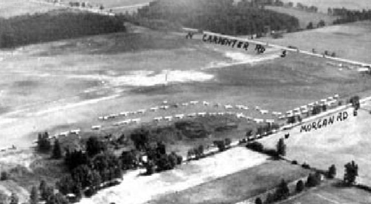
An undated aerial view looking northeast depicted a huge number of aircraft at Ypsilanti Airport, presumably for the Air Meet.
Ypsilanti Airport was chosen to host air mail service in 1929.
According to the Ypsilanti Historical Society's Winter 2008 Ypsilanti Gleanings (courtesy of Mike Denja),
“Charles Lindbergh & his wife, Ann Morrow, landed at the Ypsilanti City Airport on 9/1/30, in their Lockheed plane.
The two were making a coast-to-coast tour & stopped in at Ypsilanti to visit Alexander Ruthven, President of the University of Michigan.”
“In keeping with the Lindbergh policy of private trips for brief visits,
the ship was set down here with no advance word of the arrival & attendants at the airport failed to attach sufficient significance to the landing
to prompt local announcement of any kind,” noted The Daily Ypsilanti Press of 9/2/30.
The Ypsilanti Gleanings article continued, “The airport was made a private field on 6/10/31,
when it was purchased from the original owners by Milo & Mrs. L. W. Oliphant.”
The earliest dated depiction which has been located of Ypsilanti Airport
was a 9/10/43 aerial view looking north from the 1945 AAF Airfield Directory (courtesy of Scott Murdock).
It depicted Ypsilanti as having 3 unpaved runways & a checkerboard-painted hangar on the southeast corner.
According to the Ypsilanti Historical Society's Winter 2008 Ypsilanti Gleanings (courtesy of Mike Denja),
“Milo & Mrs. L. W. Oliphant... sold the field to Dwight Reynolds in January of 1945.”
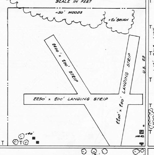
The 1945 AAF Airfield Directory (courtesy of Scott Murdock) described Ypsilanti Airport
as a 107 acre rectangular-shaped property having 3 loam runways, the longest being the 2,400' northwest/southeast strip.
The field was said to have 2 hangars, the largest being a 100' square metal structure,
and the field was described as being owned & operated by private interests.
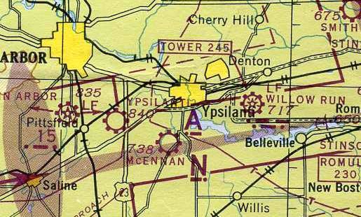
The earliest aeronautical chart depiction which has been located of Ypsilanti Airport was on the May 1945 Detroit Sectional Chart.
It depicted Ypsilanti as a commercial/municipal airport.
According to the Ypsilanti Historical Society's Winter 2008 Ypsilanti Gleanings (courtesy of Mike Denja),
“The airport was sold in August of 1946 to Donald & Lucy Gridley.”
The airport was evidently renamed Gridley Airport at some point between 1945-47,
as that is how it was listed in the 1947 MI Airport Directory (courtesy of Mike Denja).
Gridley was depicted as having 3 unpaved runways, the longest being the 2,400' northwest/southeast strip.
Three 2 hangars were depicted on the southeast corner.
According to the Ypsilanti Historical Society's Winter 2008 Ypsilanti Gleanings (courtesy of Mike Denja),
“Fifty-nine private planes responded to the Dawn Patrol Fly-in at Gridley Airport in 1947.
The airport was located on the northwest corner of Carpenter & Morgan, Pittsfield Township, and was sometimes referred to as the Ypsilanti City Airport.”
An article entitled “Gridley Moves To Ypsilanti Airport” in the 8/29/48 Ann Arbor News (courtesy of Ed Vielmetti)
said that Gridley Flying Service had spent more than 14 months at Ann Arbor's city airport
before moving to its newly-purchased airfield, formerly known as the Ypsilanti Airport.
It said Gridley's former quarters at the Ann Arbor Airport have been subleased to the Airway Equipment Sales & Service Company.
The earliest photo which has been located of Gridley Airport was a 1949 aerial view (courtesy of Mike Denja).
It depicted Ypsilanti as having 3 unpaved runways, and a total of 4 hangars on the southeast corner,
of which one had a checkerboard-painted roof.
One single-engine aircraft was visible parked outside next to the main hangar.
The last aeronautical chart depiction which has been located of Gridley Airport was on the 1949 Detroit Sectional Chart.
It depicted Gridley as having a 2,400' unpaved runway.
An article entitled “County Offered Gridley Airport” in the 10/12/49 Ann Arbor News (courtesy of Ed Vielmetti)
said that the owners of the Gridley Airport offered to sell it to Washtenaw County for $40,000.
An article entitled “Gridley Airport, Buildings Sold to Beverage Firm” in the 6/10/50 Ann Arbor News (courtesy of Ed Vielmetti)
said that the purchase of Gridley Airport had been announced by Jack Smith Beverages Inc.,
which intended to use the 113 acres for a new beer distribution point.
The last labeled depiction which has been located of Gridley Airport was on the 1954 USGS topo map (courtesy of Mike Denja).
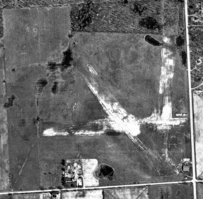
A 1955 aerial view did not show any aircraft visible at Gridley Airport.
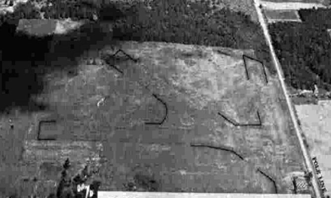
A 1956 aerial photo (courtesy of Mike Denja) appeared to show the field after it had closed,
as the runways were less distinct than in previous photos,
there were no aircraft visible on the field, and the hangars on the southeast corner appeared to have been fenced-off from the rest of the property.
According to the Ypsilanti Historical Society's Winter 2008 Ypsilanti Gleanings (courtesy of Mike Denja),
“The Gridley Airport remained in operation possibly as late as the 1960s.
The story of the airport ends because the space needed for the expansion of U.S. 23 made it unsafe for the landing of planes.
Airplanes & airports were once the vision of the future, and this airport was closed because of the need for other means of transportation.”
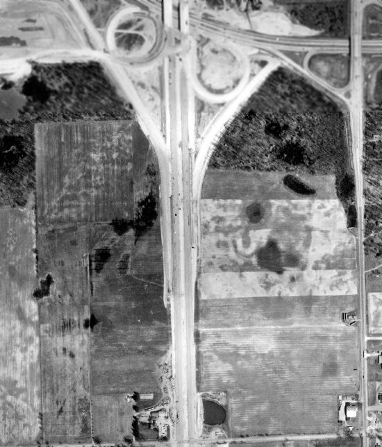
A 1962 aerial photo (courtesy of Mike Denja) showed the reason for Gridley Airport's demise:
with Route 23 having been constructed through the western portion of the airfield.
The hangars still remained standing on the southeast corner.
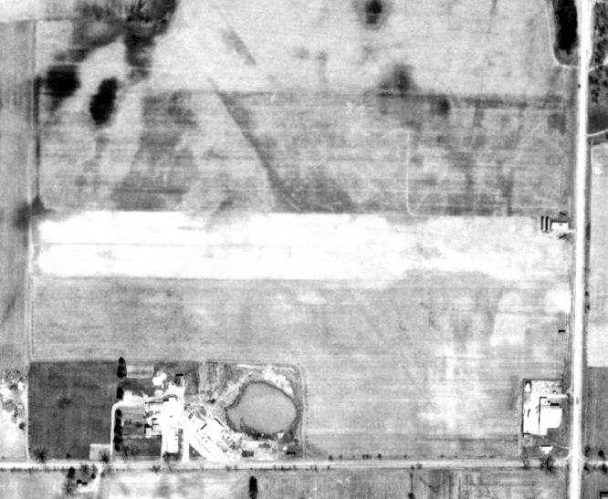
The 3 hangars on the southeast corner of the Gridley Airport site were still present on a 1973 aerial photo.
The last trace of Gridley Airport was removed at some point between 1973-2000,
as a 2000 aerial photo showed that the 3 former hangars on the southeast side had been replaced by a commercial building.
According to the Ypsilanti Historical Society's Winter 2008 Ypsilanti Gleanings (courtesy of Mike Denja),
“I-94 crossed through a portion of the airport & US-23 went through the western portion of the airport.
Today the Daniel L. Jacob & Co. Inc. (Budweiser beer distribution outlet) and an inflatable tennis court occupy much of the corner property.”
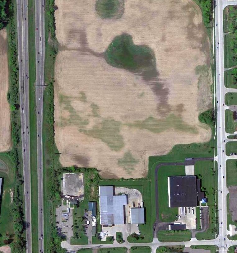
A 5/9/10 aerial photo showed no trace remaining of Gridley Airport.
The site of Gridley Airport is located northwest of the intersection of Carpenter Road & Morgan Road.
Thanks to Mike Denja for pointing out this airfield.
____________________________________________________
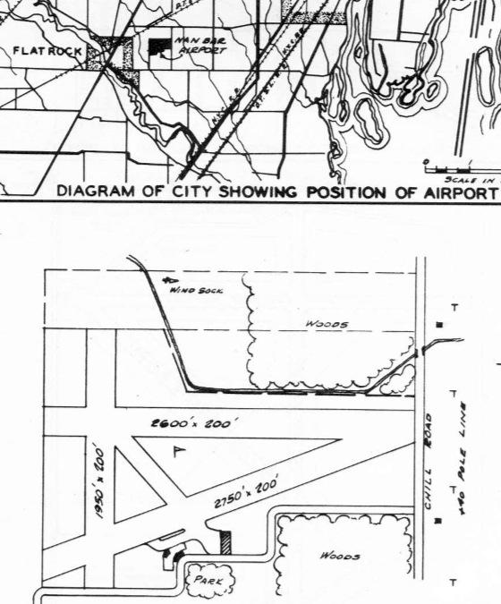
Nan Bar Airport / NOLF 27106 / Flat Rock Field, Flat Rock, MI
42.103, -83.27 (Southwest of Detroit, MI)
“Flat Rock Field 27106”, as depicted on a circa 1942 map of NAS Grosse Ile & its Outlying Fields.
Nan-Bar Airport was owned by Red Stultz & Chet Brazer.
According to Wikipedia, Nan-Bar Airport was established in the 1930s, named for Stultz's daughters, Nancy & Barbara.
During World War II Nan-Bar Airport served as one of 16 Outlying Fields used to support flight training at Naval Air Station Grosse Ile.
Navy pilots used Nan-Bar for short field landing instruction, as well as for emergency landings.
According to Brian Rehwinkel, “According to Navy records, the US Government leased 95 acres for this field.”
Nan Bar Airport was not yet depicted on the 1942 USGS topo map.
The earliest depiction of which has been located of Nan-Bar Airport was on a circa 1942 map of NAS Grosse Ile & its Outlying Fields.
It depicted “Flat Rock Field”, also with its Navy designator of “27106”,
which meant that it was located on a bearing of 271 degrees & a distance of 6 NM from its parent airfield, NAS Grosse Ile.

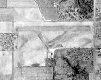
The earliest photo which has been located of Flat Rock OLF was a 10/6/43 aerial view looking east (courtesy of Brian Rehwinkel).
Brian Rehwinkel observed, “This photo shows the landing circles on the 2 sod runways.
Based on the worn grass near the circles, this field saw heavy use around this time, although there only seems to be one plane present, sitting on the southeast portion of the field.”
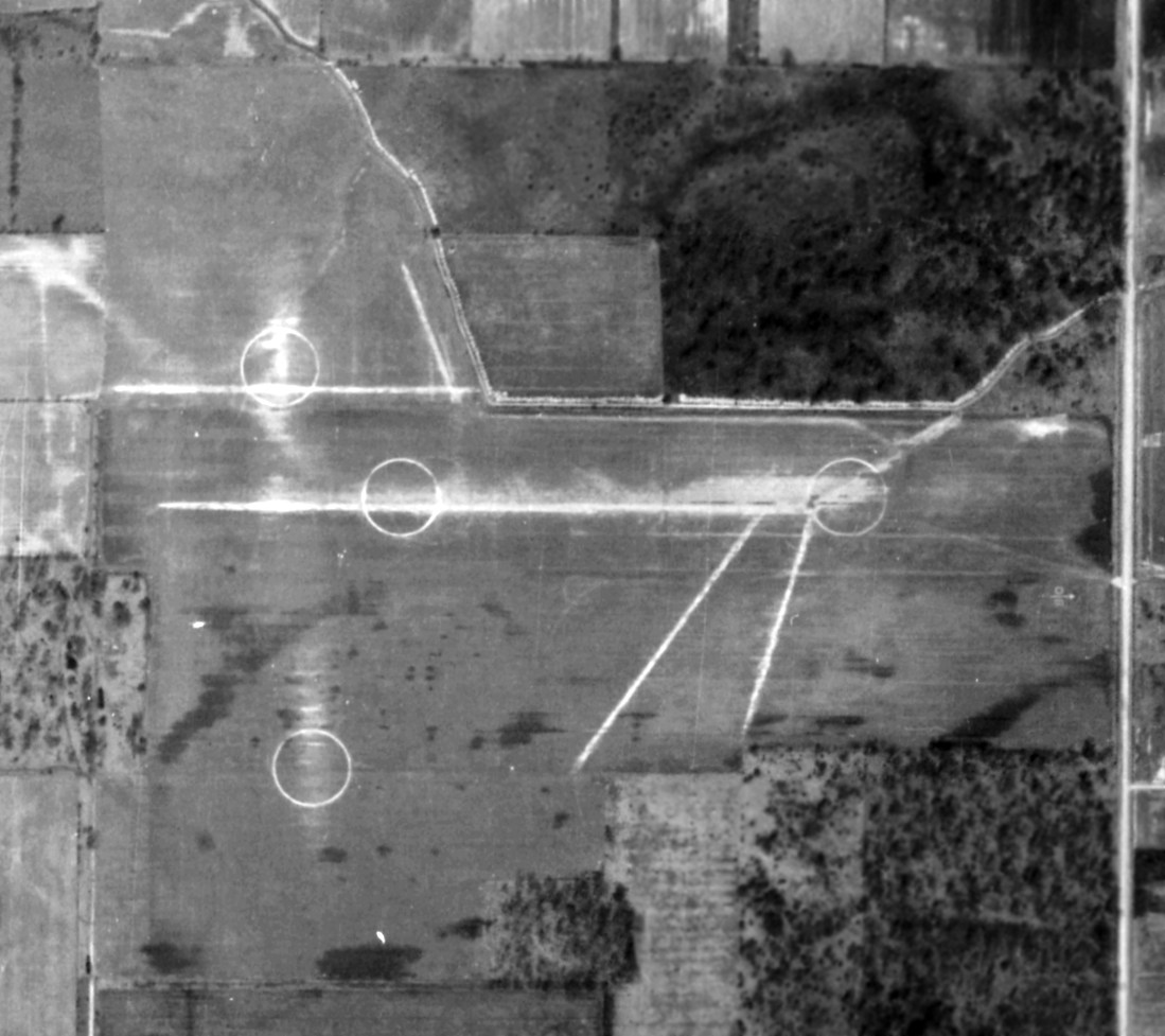
A circa 1943 aerial view of Flat Rock OLF showed the grass runways & 4 airfield circle markings (courtesy of Brian Rehwinkel).
According to Brian Rehwinkel, “The Navy most likely canceled the lease for this field at the end of the war.”
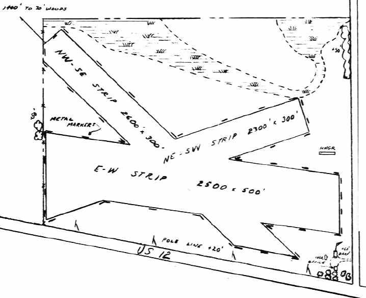
The 1946 MI Airport Directory (courtesy of Doug Ranz)
depicted Nan Bar Airport as having 3 unpaved runways, with 3 small buildings on the south side.
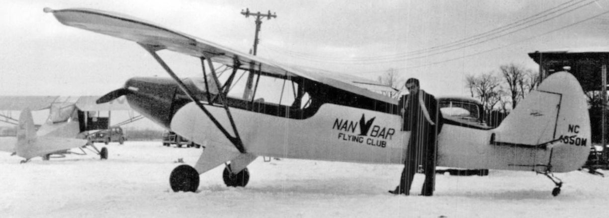
A 1948 photo of Robert Cornwell in front of a Piper Cub of the Nan Bar Flying Club at Nan Bar Airport (courtesy of Mike Denja).
Cornwell had trained to be a pilot & worked at repairing & painting planes at Nan Bar.
He also served as the observer on monthly flights piloted by Nan Bar Airport co-owner Chet Brazer
checking Detroit & Ohio Edison power lines for burned insulators.
A 1949 aerial view depicted Nan Bar Airport as having 3 unpaved runways,
with a half-dozen light planes around a small building on the south side of the field.
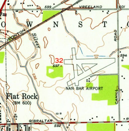
The 1952 USGS topo map depicted Nan Bar Airport as having 3 runways
and 3 small buildings on the southeast side.
The last photo which has is available showing Nan Bar Airport was a 1956 aerial view.
The field appeared to have been reduced to only the east/west runway.
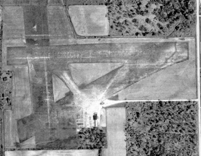
The last photo which has been located showing Nan Bar Airport was a 1964 aerial view.
A dozen light planes were visible around a small building on the south side of a single grass east/west runway.
According to Wikipedia, Nan-Bar Airport operated until the early 1960s.
The only aeronautical chart depiction which has been located of Nan-Bar Airport
was on the July 1965 Detroit Local Aeronautical Chart (courtesy of Ron Kunse).
It depicted Nan-Bar as having a 3,900' unpaved runway.
The 1969 USGS topo map depicted Nan Bar Airport as having a single unpaved east/west runway.
A 1973 aerial view showed Nan Bar Airport after it had been abandoned.
The area of the grass east/west runway remained clear, and a small building remained on the south side, but there were no planes on the field.
The 1974 USGS topo map depicted Nan Bar Airport as having a single unpaved east/west runway.
A 1993 aerial view showed the last remaining building from Nan Bar Airport had been removed at some point between 1973-93.
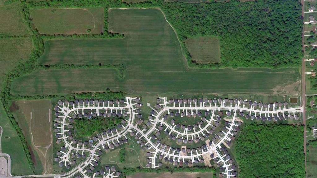
Amazingly a 5/9/10 aerial photo showed that the east/west grass runway of Nan Bar Airport remained clear & recognizable after more than 40 years.
Houses covered the airport ramp area.
The site of Nan Bar Airport is located northwest of the intersection of Gilbraltar Road & Cahill Road.
Thanks to Michael McMurtrey for pointing out this airfield.
____________________________________________________
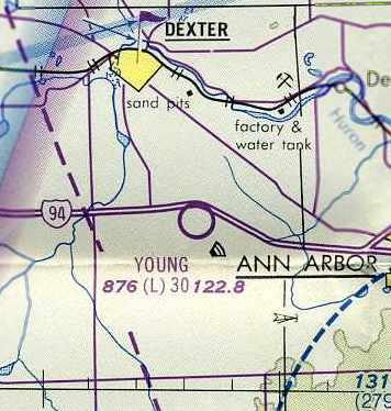
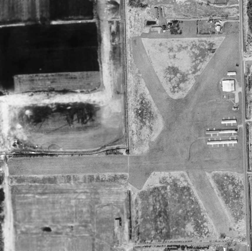
Washtenaw Airport / Young Airport, Ann Arbor, MI
42.295, -83.864 (West of Detroit, MI)
Washtenaw Airport, as depicted in the 1946 MI Airport Directory (courtesy of Doug Ranz).
This little general aviation field was evidently established at some point in 1946,
as it was not yet depicted at all on the July 1946 Detroit Sectional Chart (according to Chris Kennedy).
Tina Dowis reported, “My grandfather Robert MacVicar was founder/owner-operator of the Washtenaw Airport.
He also was a pilot in WWII... after the service he then built this airport
and taught flying in the Ann Arbor area for many years.
He also flew many years with Bill Barber who both were known for their airshows.”
The earliest depiction of Washtenaw Airport which has been located
was in the 1946 MI Airport Directory (courtesy of Doug Ranz).
It depicted the field as having 3 unpaved runways (with the longest being the 2,600' northwest/southeast strip),
and having a single hangar on the east side.
The December 1947 Detroit Sectional Chart (courtesy of Chris Kennedy)
depicted Washtenaw as a commercial/municipal airport.
The 1949 Detroit Sectional Chart (courtesy of Donald Felton)
depicted Washtenaw as having a 2,600' unpaved runway.
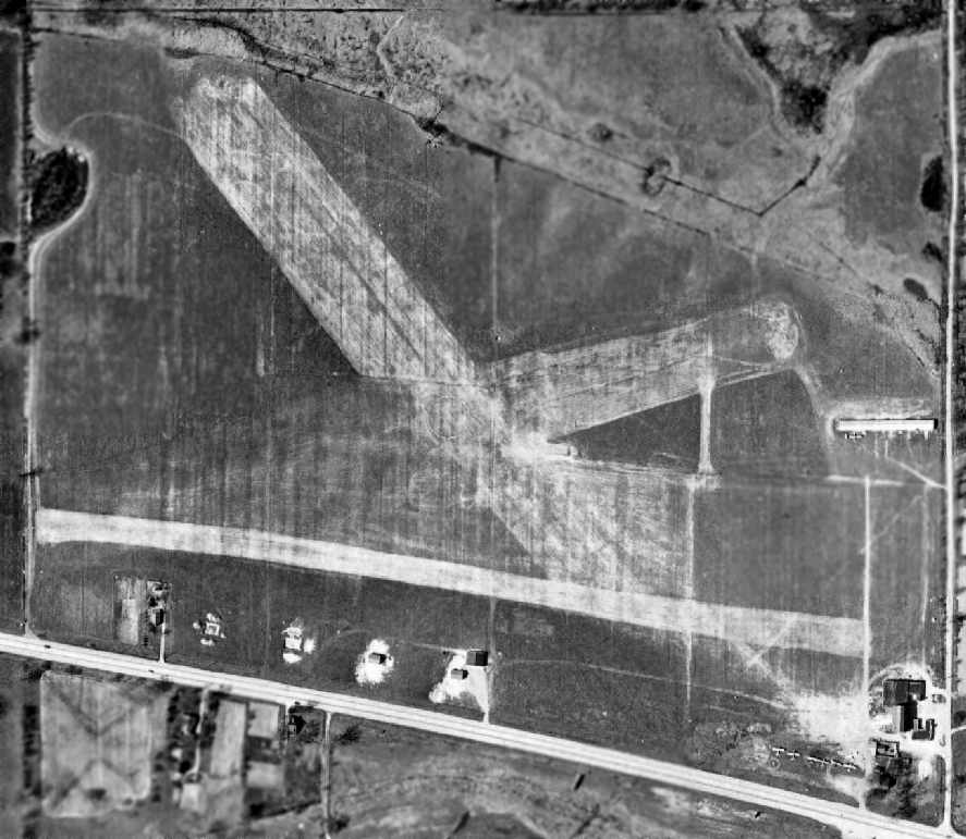
A 1949 aerial photo of Washtenaw Airport, from Wayne State University (courtesy of Greg Steinmayer).
The field had 3 unpaved runways, along with a row of T-hangars on the east side of the field.
A total of 6 light single-engine aircraft were visible parked on the southeast corner of the field.
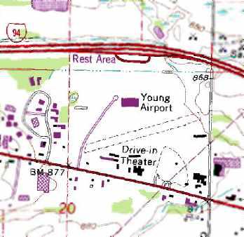
A 1955 aerial photo of Washtenaw Airport showed that the southeast corner of the field had been taken up by a drive-in movie theater,
which considerably changed the airport's configuration.
The former east/west strip was gone,
and the former southeast/northwest strip had been relocated somewhat farther north, to avoid the drive-in theater.
The total number of aircraft visible parked on the field had decreased to only 3,
all on the south side of the field.
It was still depicted as Washtenaw Airport on the May 1957 Detroit Sectional Chart (according to Chris Kennedy).
A 1961 aerial photo of Washtenaw Airport from Wayne State University (courtesy of Greg Steinmayer)
showed that an additional row of T-hangars had been added at some point between 1955-61 on the northwest side of the field.

A 1963 aerial view of Young Airport showed that 3 more rows of T-hangars had been added at some point between 1961-63 on the south side side of the field.
The number of aircraft visible parked outdoors had also increased to 7.
The airport was evidently renamed “Young” at some point between 1957-65,
as that is how it was labeled on the July 1965 Detroit Sectional Chart (courtesy of Chris Kennedy).
It was depicted as having a 3,000' unpaved runway.
According to Robert Young Jr., “I was told as a boy from my mother
that it was named in honor of my dad Robert Young Sr.,
who was a pilot & trainer back in the 1940s & 1950s.
My dad worked at Willow Run flying the bombers, and trained many others to do that too.
He worked at Ann Arbor Airport for many years, and helped start the Civil Air Patrol.
Sadly my father passed away in a training accident in 1953, 2 months before I was born.
My Uncle Ernie & my mom used to tell me about the runway being named for him after his death.”
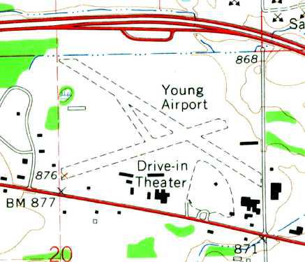
The 1965 USGS topo map depicted Young Airport as having 2 unpaved runways.
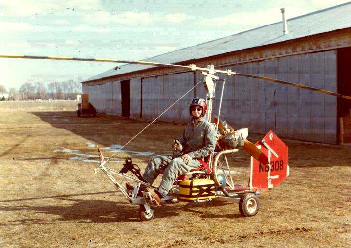
The last photo which has been located showing Washtenaw Airport in operation was a 1975 photo of Howard Cooper in his Bensen BM8 Gyrocopter.
Howard recalled, “When I was a senior in high school in Oak Park, Michigan, I built a Benson BM8 Gyrocopter.
In 1974, while a freshman at the University of Michigan, I located a small airport not too far from campus - Young Field -
and worked out a deal with a mechanic to allow me to park my Gyrocopter in his hangar for $25/month.
I flew the Gyro in the area for about a year. Eventually I sold it & moved on.”
The last aeronautical chart depiction which has been located of Young Airport
was on the May 1976 Detroit Terminal Aeronautical Chart (courtesy of Chris Kennedy).
It depicted Young as having a 3,000' unpaved runway.
The 1977 USGS topo map showed that Young Airport had lost its longest runway at some point between 1965-77,
leaving only the northeast/southwest runway.
Dave Lyjak recalled of Young Airport, “My dad kept his airplane there for a number of years in the 1970s-80s period
and I learned to fly & soloed there (also learned to drive a stick shift).
We also used to go to the drive-in the southeast corner –
the 1st time I saw 'Blue Max' although Mom & Dad made my brother & I lie down in the back seat whenever Ursula Andress was on screen.”
Young Airport evidently was closed (for reasons unknown) at some point between 1976-80,
as it was no longer listed among active airports in the 1980 AOPA Airports USA directory (according to Chris Kennedy),
nor depicted at all on the October 1983 Detroit Terminal Aeronautical Chart (according to Chris Kennedy).
Although it had evidently already been closed for at least 3 years,
the 1983 USGS topo map still depicted Young Airport as having a single unpaved northeast/southwest runway,
with several rows of T-hangars on the southwest & east sides.
The 1991 USGS topo map still depicted Young Airport as having a single northeast/southwest runway.
A 1992 aerial photo showed that the hangars remained standing,
and the area of the northeast/southwest runway remained clear, but was no longer recognizable as a runway.
A 1998 USGS aerial photo showed that the former T-hangars remained standing,
but a strange paved item had been built over the center of the airfield at some point between 1992-98.
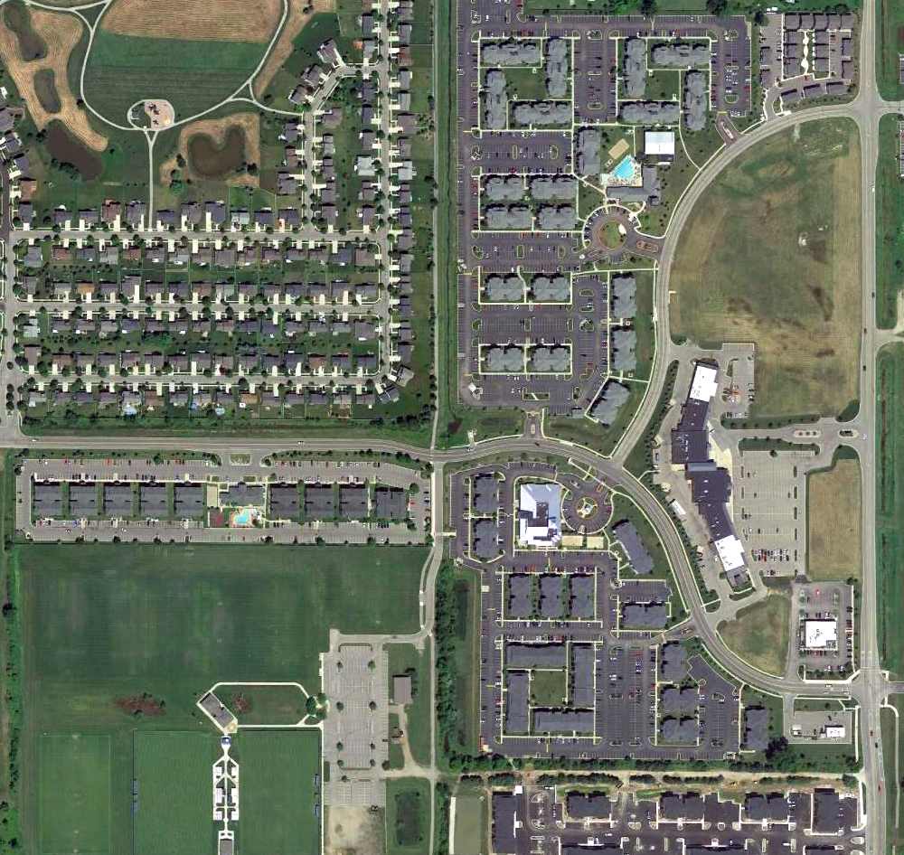
A 2005 aerial photo showed that the long row of T-hangars on the east side of the field had been removed at some point between 1998-2005.
A 2006 aerial photo showed that a large industrial building had been built over the western portion of the runway area at some point between 2005-2006.
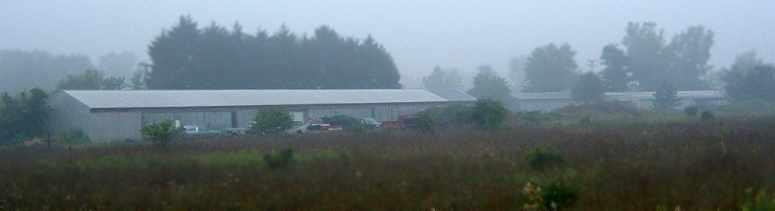
A 2006 photo by Greg Steinmayer. Greg reported, “On the Southern side of the field are 3 large, long hangar buildings,
which I presume to be T-hangars since they have doors on both sides.”
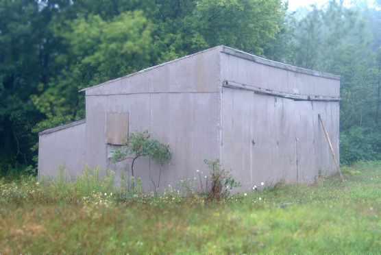
A 2006 photo by Greg Steinmayer. According to Greg, “On the Eastern end of the field are a lonely T-hangar,
and the foundations of a larger group of T-hangars.”
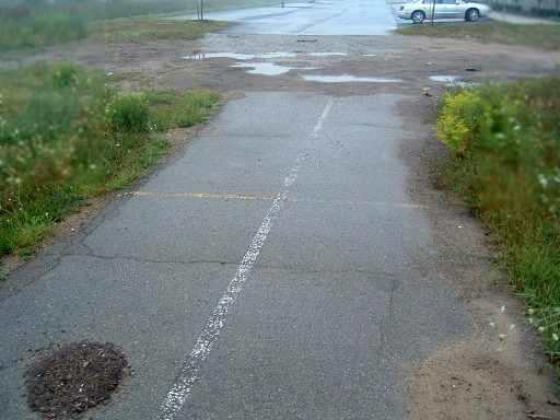
A 2006 photo of Greg Steinmayer of former runway or taxiway pavement.
According to Greg, “In the middle of the field is that weird paved area which I think MIGHT have been a runway,
but it is very narrow - no more than 8' wide, however it has some markings.
The area is now partially covered by a new industrial building which did not show up in the 1998 aerial photo.”
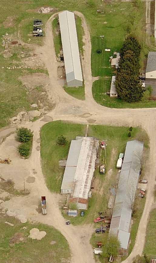
A circa 2006-2010 aerial view looking east at former hangars at the site of Young Airport.
A 10/4/11 aerial photo showed that several T-hangars remained standing on the south side of the Young Airport site.
The site of Young Airport is located northwest of the intersection of Jackson Road & North Staebler Road.
____________________________________________________
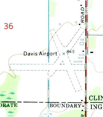
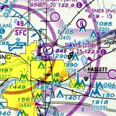
Davis Airport (2D8), East Lansing, MI
42.774, -84.488 (Northwest of Detroit, MI)
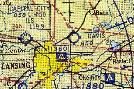
Davis Airport, as depicted on the November 1954 Milwaukee Sectional Chart (courtesy of Chris Kennedy).
This little general aviation field was evidently established at some point between 1948-54,
as it was not yet depicted on the December 1948 Milwaukee Sectional Chart (according to Chris Kennedy).
The earliest depiction of Davis Airport which has been located
was on the November 1954 Milwaukee Sectional Chart (courtesy of Chris Kennedy).
It depicted Davis as having a 2,100' unpaved runway.
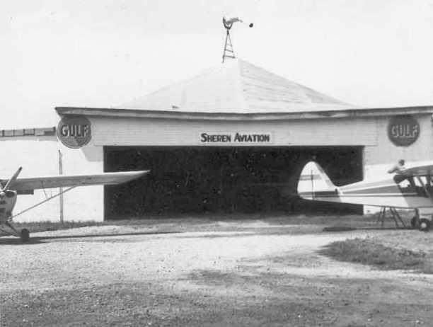
A July 1962 photo by John Mathieson of the Sheren Aviation hangar at Davis Airport.
John Mathieson recalled, “I used to fly out of Davis Airport.
It was owned back in the 1960s by Art Davis, a local farmer & long time barnstormer.
Dale Sheren was the fixed base operator.”
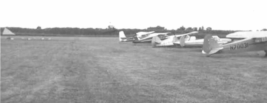
A circa 1960s photo by John Mathieson of 5 planes on the Davis Airport flightline.
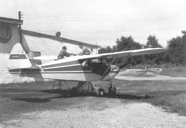
A circa 1960s photo by John Mathieson of a Piper Tri-Pacer being serviced next to the Sheren Aviation hangar at Davis Airport.
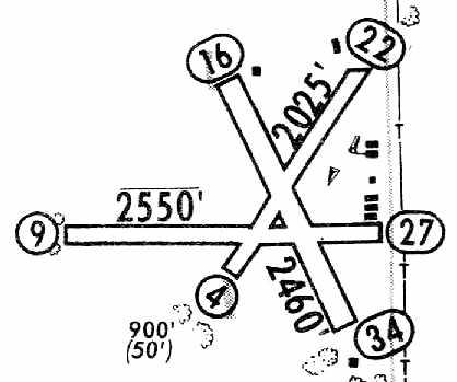
The 1965 Jeppesen Airway Manual (courtesy of Chris Kennedy)
depicted Davis as having 3 unpaved runways, with the longest being the 2,550' Runway 9/27.
Six buildings were depicted on the east side of the field.
The manager was listed as Dale Sheren.
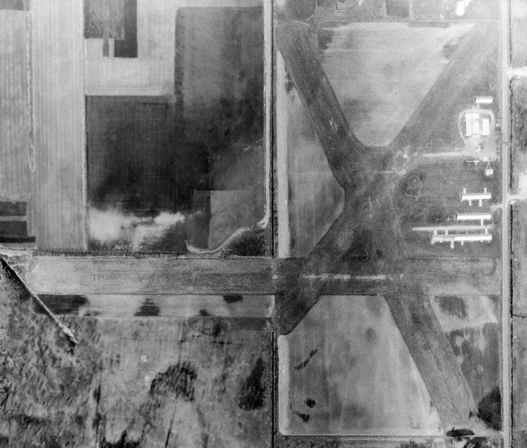
The last photo which has been located showing aircraft at Davis Airport was a 4/1/70 USGS aerial view.
It depicted Davis as having 3 grass runways, 5 hangars, and 3 single-engine aircraft.
The 1972 USGS topo map depicted Davis as having 3 unpaved runways.
Leonard Rahilly recalled, “I used to fly out of Davis Airport - approximately 1976-89.
I bought the 1957 Champion 7FC that was used by Dale Sheren for primary training & in which I got my private [pilot's] license.
I believe it was put up for sale after Dale died, in anticipation of a new FBO coming in.
After I recovered the plane, I stored it in half of the big hangar.
It was definitely a part of many local student pilots' lives & probably of some who rented it after they got their licenses.
I knew Art Davis a little bit, because he would sometimes come in & sit in the office.
I could tell you the little bit I gleaned from seeing him, hearing about him, and very, very occasionally, talking with him.
I also flew with the FBO that took over after Dale Sheren died.
[They used a] C-152 for primary, C-172 for commercial & instrument.”
Leonard continued, “Davis Airport was almost on a line with Capital City Airport's east/west runway, so the pattern altitude was only 800'.
There WERE some pretty big planes passing right over Davis.
Fortunately, Capital City was several miles to the west, and I don't think there was ever any danger of a collision with Davis traffic as long as the latter did what it was supposed to.
It was one of those places where you could meet a lot of local pilots if you wanted to, and it was OK to hang around the office a bit.
You could pump your own gas & then go in and pay.
In the late 70s, when I started lessons at Davis, Art Davis would occasionally come in to the office, although I believe he did not fly any more at that point.
He was not a talkative fellow, at least not to us neophytes.”
Ron Nelson recalled Davis Airport, “I housed my plane there (Stinson 108-3)
and took my lessons & received my license there in the late 1970s / early 1980s.
At that time there were 10-15 planes housed in the hangars near Runway 9/27.
There was also a larger hangar used by the field operators to house their trainers (they had 2) & an on-site mechanic.
When I flew out of Davis it was well maintained & a lot of fun to hang out at.”
The 1982 AOPA Airports USA directory (courtesy of Ed Drury)
described Davis Airport as having 3 turf runways, with the longest being the 2,600' Runway 9/27.
The field was said to offer fuel, hangars, tiedowns, charter, flight instruction, and aircraft rental.
The operators were listed as Sheren Aviation & Community Aviation.
Claus Buchholz recalled, “My first visit to Davis was to seek aerobatics instruction.
In Winter & Spring of 1987, Community Aviation's excellent instructor taught me precision fun flying in his 152 Aerobat.
Later I earned my instrument rating, commercial license, and CFI there, and became an instructor at their flight school.
It was a great place for flying & for hangar flying. I have never found that sense of community at any other airport since.
I hangared my Citabria there from the day I bought it in 1987 until the sad day the airport closed. Davis Airport is missed.”
A 1993 USGS aerial photo showed no aircraft parked outside at Davis Airport.
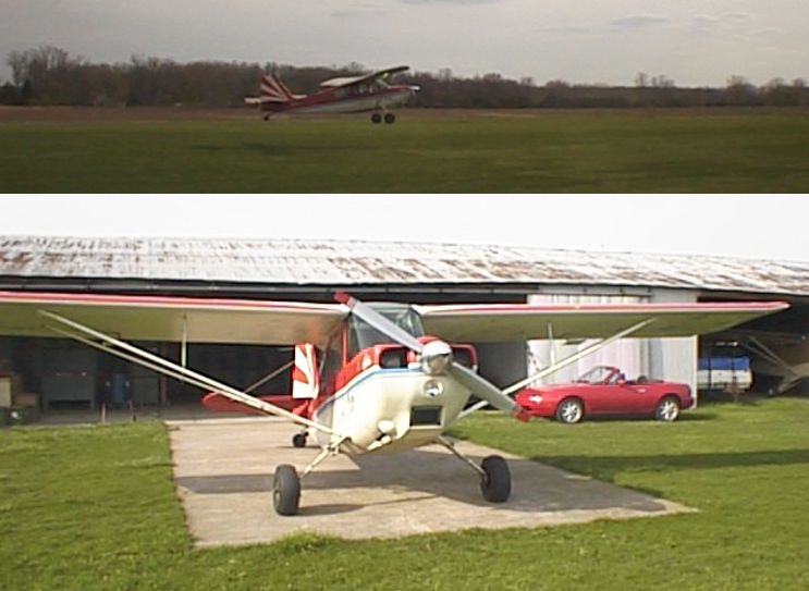
Two 1998 photos by Claus Buchholz of his Citabria at Davis Airport.
The March 1999 Detroit Sectional Chart (courtesy of Richard Finley) depicted Davis as having a 2,500' unpaved runway.
In the 1999 USGS aerial photo, Davis Airport unfortunately appeared to be a little airport on its last legs,
with not a single aircraft visible on the field.
The field was otherwise still intact, though, with 3 clear grass runways & 5 hangars.
Davis Airport was “closed permanently, effective 4/5/00”,
according to the MI Bureau of Aeronautics (courtesy of Chris Kennedy).
According to Ron Nelson, “The field was closed because the land was sold off
for apartment buildings that are used primarily by Michigan State University students (a couple of miles south),
a small strip mall & some individual houses just north of the site.”
A 2005 aerial photo showed houses had covered the site of Davis Airport.
A 2015 aerial photo showed no trace remaining of Davis Airport.
The site of Davis Airport is located northwest of the intersection of Coleman Road & Chandler Road.
____________________________________________________
Since this site was first put on the web in 1999, its popularity has grown tremendously.
That has caused it to often exceed bandwidth limitations
set by the company which I pay to host it on the web.
If the total quantity of material on this site is to continue to grow,
it will require ever-increasing funding to pay its expenses.
Therefore, I request financial contributions from site visitors,
to help defray the increasing costs of the site
and ensure that it continues to be available & to grow.
What would you pay for a good aviation magazine, or a good aviation book?
Please consider a donation of an equivalent amount, at the least.
This site is not supported by commercial advertising –
it is purely supported by donations.
If you enjoy the site, and would like to make a financial contribution,
you
may use a credit card via
![]() ,
using one of 2 methods:
,
using one of 2 methods:
To make a one-time donation of an amount of your choice:
Or you can sign up for a $10 monthly subscription to help support the site on an ongoing basis:
Or if you prefer to contact me directly concerning a contribution (for a mailing address to send a check),
please contact me at: paulandterryfreeman@gmail.com
If you enjoy this web site, please support it with a financial contribution.
please contact me at: paulandterryfreeman@gmail.com
If you enjoy this web site, please support it with a financial contribution.
____________________________________________________
This site covers airfields in all 50 states.