Abandoned & Little-Known Airfields:
Northeastern New Mexico
© 2002, © 2016 by Paul Freeman. Revised 9/10/16.
This site covers airfields in all 50 states: Click here for the site's main menu.
____________________________________________________
Please consider a financial contribution to support the continued growth & operation of this site.
CCES Airfield (revised 2/22/14) - La Mesa Park Airport (added 9/10/16) - Landing Field 78A / Anton Chico Intermediate Field (added 7/27/15)
Landing Field 73A / Otto Intermediate Field (added 7/30/15) - Philmont Scout Ranch Airfield (revised 2/7/16)
(Original) Taos Airport / Kachina Airport (revised 1/11/12) - Zia Field (revised 1/11/12)
___________________________________________________________
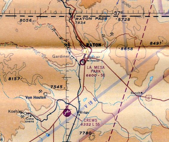
La Mesa Park Airport, Raton, NM
36.861, -104.449 (Northeast of Albuquerque, NM)
La Mesa Park Airport, as depicted on the September 1965 Trinidad Sectional Chart (courtesy of Ron Kunse).
The date of establishment of this small general aviation airport has not been determined.
The earliest depiction which has been located of La Mesa Park Airport was on the September 1965 Trinidad Sectional Chart (courtesy of Ron Kunse).
It depicted La Mesa Park Airport as having a 5,000' unpaved runway.

The 1971 USGS topo map depicted La Mesa Park Airport as having a single paved northwest/southeast runway,
labeled simply as “Airport”, with one small building on the northeast corner.

The last labeled depiction which has been located of La Mesa Park Airport was on the 1976 USGS topo map.

The only photo which has been located showing an aircraft at La Mesa Park Airport was a 1997 USGS aerial view looking southwest.
It depicted one single-engine light aircraft parked on the ramp near the small building on the northeast side (bottom-right of photo).
La Mesa Park Airport was evidently closed (for reasons unknown) at some point between 1997-2004,
as a 2004 aerial view depicted multiple yellow closed-runway “X” symbols painted along the runway.

A 2014 aerial view looking southwest showed the La Mesa Park Airport remained intact, though deteriorated.
La Mesa Park Airport is located southwest of the intersection of York Canyon Road & La Mesa Drive.
Thanks to Eric Karnes for pointing out this airfield.
______________________________________________________
Landing Field 73A / Otto Intermediate Field, Otto, NM
35.07 North / 106.01 West (Northeast of Albuquerque, NM)

Otto Intermediate Field was depicted on the March 1932 Albuquerque Sectional Chart as Landing Field #73A.
Otto Intermediate Field was one of the nationwide network of Intermediate Fields
established by the Commerce Department in the 1930s along commercial airways between major cities.
The date of establishment of Otto Intermediate Field has not been determined.
The earliest depiction which has been located of Otto Intermediate Field was on the March 1932 Albuquerque Sectional Chart,
which labeled it as Landing Field 73A.

The earliest photo which has been located of Otto Intermediate Field was a circa 1943-45 aerial view
from the 1945 AAF Airfield Directory (courtesy of Scott Murdock).
It depicted Otto as a triangular-shaped unpaved landing area.
The 1945 AAF Airfield Directory (courtesy of Scott Murdock) described Otto Intermediate Field
as a 153 acre L-shaped property having 3 sand & sod landing strips, the longest being the 4,100' northeast/southwest strip.
The field was said to not have any hangars, to be owned by private interests, and operated by the Civil Aeronautics Administration.

The 1956 USGS topo map depicted “Otto Airfield” as an L-shaped unpaved landing area.

The last aeronautical chart depiction which has been located of Otto Intermediate Field was on the 1960 Albuquerque Sectional Chart,
which labeled it as “Otto (FAA)”, and depicted it as having a 4,100' unpaved runway.

The last depiction which has been located of Otto Airfield was on the 1963 USGS topo map.
Otto Intermediate Field was evidently closed at some point between 1963-68,
as it was no longer depicted on the February 1968 Albuquerque Sectional Chart.

A 1996 USGS aerial view looking northwest showed the remains of the east/west runway at the site of Otto Intermediate Field.

A 2014 aerial view looking northwest showed the remains of the east/west runway at the site of Otto Intermediate Field.

A undated (pre-2015) photo of a building (with “Otto” still visible on the roof) at the site of Otto Intermediate Field.
The site of Otto Intermediate Field is located northeast of the intersection of Route 41 & County Road 6A.
Thanks to Matt Franklin for pointing out this airfield.
______________________________________________________
Landing Field 78A / Anton Chico Intermediate Field, Anton Chico, NM
35.14 North / 105.08 West (Northeast of Albuquerque, NM)

Anton Chico Intermediate Field was depicted on the March 1932 Albuquerque Sectional Chart as Landing Field #78A.
Anton Chico Intermediate Field was one of the nationwide network of Intermediate Fields
established by the Commerce Department in the 1930s along commercial airways between major cities.
The date of establishment of Anton Chico Intermediate Field has not been determined.
The earliest depiction which has been located of Anton Chico Intermediate Field was on the March 1932 Albuquerque Sectional Chart,
which labeled it as Landing Field 78A, and also depicted Airway Beacon 78B nearby to the southeast.

The earliest photo which has been located of Anton Chico Intermediate Field was a circa 1943-45 aerial view
from the 1945 AAF Airfield Directory (courtesy of Scott Murdock).
It depicted Anton Chico as an irregularly-shaped unpaved landing area.
The 1945 AAF Airfield Directory (courtesy of Scott Murdock) described Anto Chico Intermediate Field
as a 163 acre irregularly-shaped property having 2 sand & sod landing strips, measuring 4,273' north-northwest/south-southeast & 3,615' east-northeast/west-southwest.
The field was said to not have any hangars, to be owned by private interests, and operated by the Civil Aeronautics Administration.

The last depiction which has been located of Anton Chico Intermediate Field was on the 1960 Albuquerque Sectional Chart,
which labeled it as “Anton Chico (FAA) 79A”, and depicted it as having a 4,300' unpaved runway.
Anton Chico Intermediate Field was evidently closed at some point between 1960-68,
as it was no longer depicted on the February 1968 Albuquerque Sectional Chart.

A 1991 USGS aerial view depicted the remains of Anton Chico Intermediate Field.
Matt Franklin observed, “The defined tracks measure 4,300' (oriented) 16/34 & 3,600' (oriented) 6/24.”

A 2014 aerial view showed Anton Chico Intermediate Field remained recognizable.
The site of Anton Chico Intermediate Field is located southwest of the intersection of County Road 4 L & Sun Ranch Road.
Thanks to Matt Franklin for pointing out this airfield.
______________________________________________________
Philmont Scout Ranch Airfield, Cimarron, NM
36.49, -104.95 (Northeast of Albuquerque, NM)

The Philmont Scout Ranch Airfield, as depicted on the 1958 USGS topo map.
Photo of the airfield while in use has not been located.
This airfield on the north side of the Boy Scout Philmont Ranch may have been established at some point between 1956-58,
as it was not yet depicted on the 1956 USGS topo map.
The earliest depiction which has been located of the Philmont Scout Ranch Airfield was on the 1958 USGS topo map.
Mark Rands recalled, “The air charts had a warning to make a pass over the field to chase the buffalo off the runway.”
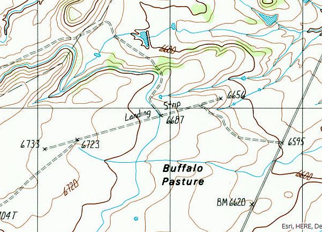
The 1987 USGS topo map depicted a single northeast/southwest “Landing Strip”.
The last reported aircraft use of the Philmont Scout Ranch Airfield was an NTSB summary of an 8/2/88 accident
in which a Beech B23 Musketeer departed from the field but subsequently crashed due to water contamination of its fuel.

The 1990-91 NM Aeronautical Chart (courtesy of Alex Hauzer) depicted “CS Ranch” Airfield at the general location of Philomont – was this the same airfield?
CS Ranch was depicted with the “Warning – uncertain or unknown” airfield symbol, and shown to have a 3,800' unpaved runway.

The earliest photo which has been located of the Philmont Scout Ranch Airfield was a 1991 USGS aerial view looking west.
The runway looked very deteriorated.

A 2010 aerial view looking west showed the Philmont Scout Ranch Airfield runway remained recognizable, along with a segmented circle marking in the lower-right.
The Philmont Scout Ranch Airfield is located on the west side of Route 21, one mile north of the Scout Ranch headquarters.
Thanks to Mark Rands for pointing out this airfield.
______________________________________________________
36.08 North / 104.43 West (Northeast of Albuquerque, NM)
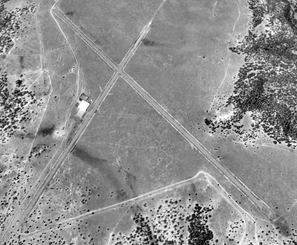
A 9/29/97 USGS aerial view looking southwest at the CCES Airfield.
No airfield at this location was yet depicted on the February 1968 Albuquerque Sectional Chart.
The Canyon Colorado Equine Sanctuary (CCES) was established by William Gruenerwald,
a petroleum geologist who made money in the oil business & proceeded to spend a lot of it on an extraordinary personal crusade.
His objective was to protect zebras, onagers, kulans and other wild relatives of the domestic horse from the threat of extinction.
The focal point of his work is the CCES, a 6,000-acre private preserve which includes solar-heated shelters, grain- & hay-storage sheds, water tanks,
residential buildings and a headquarters complex with an aircraft hangar, modern offices and a veterinary clinic.
John Love reported, “The first USGS image I found had an aircraft sitting next to the hangar & the airstrip was still in good condition.
As I remember the image was made in the late 1970s.
A building has C.C.E.S. lettering on the concrete apron of a small hangar.”
The earliest depiction which is available of the CCES Airfield was a 9/29/97 USGS aerial photo.
It depicted 2 paved runways, with a ramp & hangar to the southeast of the runway intersection.

The 1998 USGS topo map depicted 2 unpaved runways, labeled simply as “Landing Strips”,
along with a single small building to the southeast of the runway intersection.
A 7/20/04 aerial photo showed large “C.C.E.S.” letters painted in black on the ramp in front of the hangar.

The only photo which has been located showing an aircraft at the CCES Airfield was an 8/13/04 aerial view,
showing a light twin-engine aircraft (Beech Baron?) on the ramp next to the hangar.
A 5/8/09 aerial photo showed the “C.C.E.S.” letters had been repainted in white on the ramp in front of the hangar.

A 10/22/12 aerial view looking southwest showed the CCES Airfield to remain intact, though the runways were somewhat deteriorated.
As of 2013, no airfield was listed at this location in the FAA Airport/Facility Directory data nor depicted on aeronautical charts.
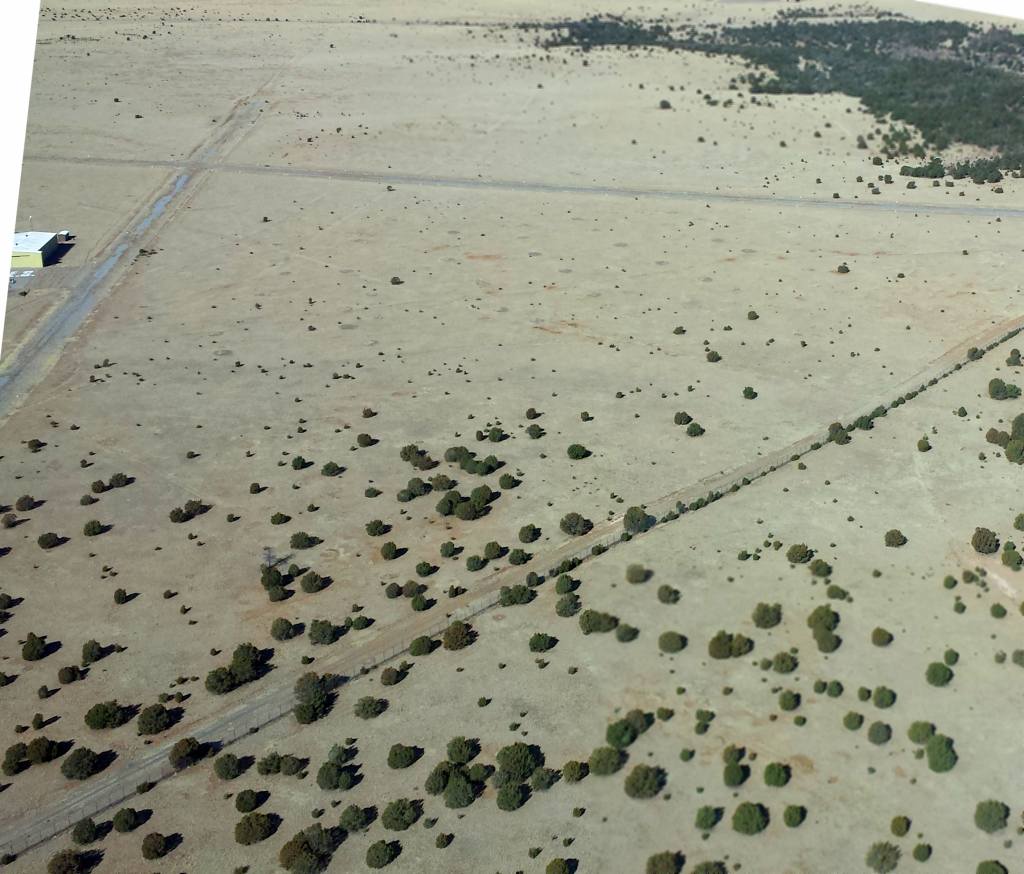
A February 2014 aerial view looking north at the CCES airfield.
The photographer observed, “The entire perimeter has a tall chainlink fence that appears to be in great condition.”

A February 2014 aerial view looking east at the CCES hangar & ramp.
The CCES Airfield is located at the northeast terminus of Mills Canyon Road.
Thanks to John Love for pointing out this airfield.
______________________________________________________
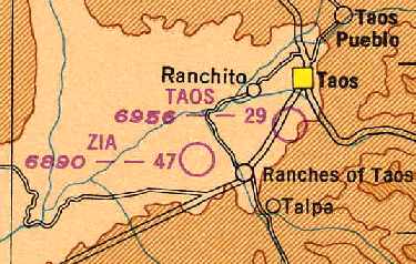
(Original) Taos Airport / Kachina Airport, Taos, NM
36.38 North / 105.59 West (Northeast of Albuquerque, NM)
Taos Airport, as depicted on the March 1949 Trinidad Sectional Chart (courtesy of Chris Kennedy).
Photo of the airfield while open has not been located.
The original airport for the town of Taos was located on the southwest side of the town.
The Taos Airport was evidently established at some point between 1945-49,
as it was not yet listed among active airfields in the 1945 AAF Airfield Directory (courtesy of Scott Murdock).
The earliest depiction of the Taos Airport which has been located
was on the March 1949 Trinidad Sectional Chart (courtesy of Chris Kennedy).
It depicted Taos as having a 2,900' unpaved runway.
The Taos Airport may have been closed at some point between 1949-57,
as it was not depicted at all on the November 1957 Trinidad Sectional Chart (courtesy of David Brooks).
At some point between 1957-59, the airport was evidently reopened under the name of "Kachina"
as that is how it was listed in the 1959 Flight Guide (courtesy of Chris Kennedy).
It depicted Kachina as having 2 unpaved runways: 3,871, Runway 7/25 & 2,812' Runway 5/23.
Several buildings were depicted around a ramp at the northeast corner of the field.

Kachina Airport was evidently closed (for reasons unknown) at some point between 1959-64,
as the field was labeled simply as "Landing Strip" on the 1964 USGS topo map,
which typically indicates that the airfield was closed by that point.

A single runway at the former Kachina Airport were still depicted on the 1996 USGS topo map,
but it was labeled simply as "Landing Strip".
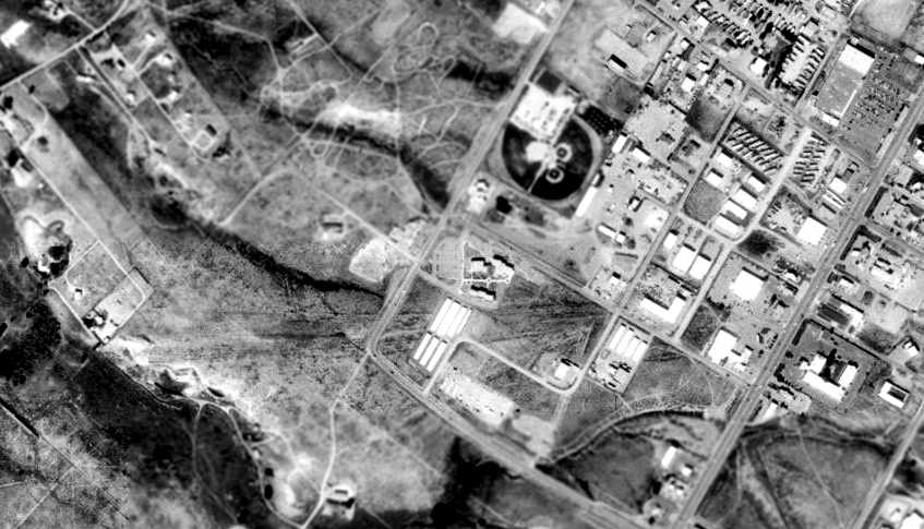
In the 1997 USGS aerial photo, the outline of Kachina's primary runway was still somewhat recognizable,
even though the majority of the property had been covered with new construction.
The site of Kachina Airport is located west of the intersection of Route 585 & Route 68.
______________________________________________________
36.37 North / 105.64 West (Northeast of Albuquerque, NM)
Zia Field, as depicted on the March 1949 Trinidad Sectional Chart (courtesy of Chris Kennedy).
Photo of the airfield while open has not been located.
This general aviation airport was evidently established at some point between 1945-49,
as it was not yet listed among active airfields in the 1945 AAF Airfield Directory (courtesy of Scott Murdock).
The earliest reference to Zia Field which has been located
on the March 1949 Trinidad Sectional Chart (courtesy of Chris Kennedy).
It depicted Zia as having a 4,700' unpaved runway.
Zia Field had 3 unpaved runways:
4,700' Runway 8/26, 4,600' Runway 5/23, and 3,800' Runway 17/35.

The November 1957 Trinidad Sectional Chart (courtesy of David Brooks)
depicted Zia Field as having a 4,700' unpaved runways.

The 3 runways of Zia Field were still depicted on the 1964 USGS topo map,
but it was labeled simply as "Landing Field".
An unpaved ramp was also depicted, east of the runway intersection, but no buildings were depicted.
Zia Field was described in the "Unattended Airports" section of the 1967 Flight Guide (according to Chris Kennedy)
as having 3 unpaved runways: 4,600' Runway 5/23, 2,700' Runway 8/26, and 3,800' Runway 17/35.
The last chart depiction of Zia as an active airfield which has been located
was on the February 1968 Trinidad Sectional Chart (according to Chris Kennedy).
Zia Field was evidently closed (for reasons unknown) at some point between 1968-79.
The 3 runways of Zia Field were still depicted on the 1979 USGS topo map,
but they were labeled simply as "Landing Strips", which typically indicates that the airfield was closed by that point.
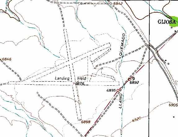
The 3 runways of Zia Field were still depicted on the 1996 USGS topo map,
but it was labeled simply as "Landing Field".
An unpaved ramp was also depicted, east of the runway intersection,
but no buildings were depicted.
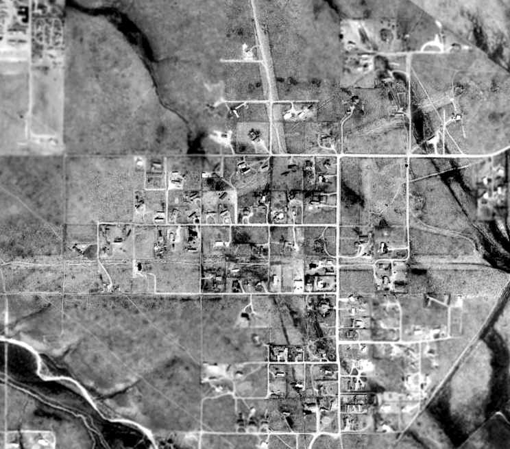
As can be seen in the 1997 USGS aerial photo, the site of Zia Field has been covered with residential streets & houses.
However, remarkably, the outline of all 3 former runways were still apparent,
around & through the streets which have otherwise covered the site.
It does not appear as if any airfield buildings have remained at the site.
Zia Field is located west of the intersection of Cuchilla Road & West Romero Road.
____________________________________________________
Since this site was first put on the web in 1999, its popularity has grown tremendously.
That has caused it to often exceed bandwidth limitations
set by the company which I pay to host it on the web.
If the total quantity of material on this site is to continue to grow,
it will require ever-increasing funding to pay its expenses.
Therefore, I request financial contributions from site visitors,
to help defray the increasing costs of the site
and ensure that it continues to be available & to grow.
What would you pay for a good aviation magazine, or a good aviation book?
Please consider a donation of an equivalent amount, at the least.
This site is not supported by commercial advertising –
it is purely supported by donations.
If you enjoy the site, and would like to make a financial contribution,
you
may use a credit card via
![]() ,
using one of 2 methods:
,
using one of 2 methods:
To make a one-time donation of an amount of your choice:
Or you can sign up for a $10 monthly subscription to help support the site on an ongoing basis:
Or if you prefer to contact me directly concerning a contribution (for a mailing address to send a check),
please contact me at: paulandterryfreeman@gmail.com
If you enjoy this web site, please support it with a financial contribution.
please contact me at: paulandterryfreeman@gmail.com
If you enjoy this web site, please support it with a financial contribution.
____________________________________________________
This site covers airfields in all 50 states.