
Abandoned & Little-Known Airfields:
Southwestern New Mexico
© 2002, © 2016 by Paul Freeman. Revised 2/7/16.
This site covers airfields in all 50 states: Click here for the site's main menu.
____________________________________________________
Please consider a financial contribution to support the continued growth & operation of this site.
Columbus Airport (revised 6/7/12) - Cotton City Landing Area (added 1/31/16) - Deming Aux AAF #1 (revised 12/8/13) - Deming Aux AAF #2 (revised 8/9/14)
Mount Riley Intermediate Field (revised 7/18/15) - Rodeo Intermediate Field (revised 6/7/12) - Turner Ridgeport Airport (revised 2/7/16)
___________________________________________________________
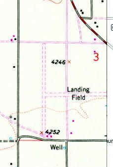
Cotton City Landing Area, Cotton City, NM
32.073, -108.877 (Southwest of Albuquerque, NM)
“Cotton City Landing Area”, as depicted on the 1964 USGS topo map.
Sam Taylor reported in 2016 of the Cotton City Airfield, “My father departed from a small dirt strip some 55 years ago [1961] & perished a few miles [away] in a crash.
It used to be maintained by the Cotton City Airmens' Association; my father was a member.”
The earliest depiction which has been located of the Cotton City Landing Area was on the 1964 USGS topo map.
It depicted 2 unpaved runways in an X shape. There were no buildings depicted on the site.
The 1980 USGS topo map depicted a completely different runway orientation at Cotton City compared to 1964,
with 2 perpendicular unpaved runways oriented north/south & east/west.
The Cotton City Landing Area was not depicted on the 1990-91 NM Aeronautical Chart (courtesy of Alex Hauzer).
A 1998 USGS aerial view looking north depicted Cotton City as having 2 perpendicular unpaved runways oriented north/south & east/west.
Sam Taylor reported in 2016, “A few years ago crop dusters used it for refueling,
but according to my relatives no one else has used it in years.
I have a brother who lives on the edge of the strip.
Another brother owns an adjoining section on the strip where the canopy (hangar) still stands & is used for farm equipment storage.”
In 2013 my brothers dragged both runways in anticipation of my landing there but it is now overgrown again.
I plan a flight every year to the strip in memory of my father but something always comes up.”

A 2014 aerial view looking north depicted the Cotton City runways as remaining recognizable but deteriorated.
The site of Cotton City Landing Area is located south of the intersection of Route 338 & County Road 81.
Thanks to Sam Taylor for pointing out this airfield.
______________________________________________________
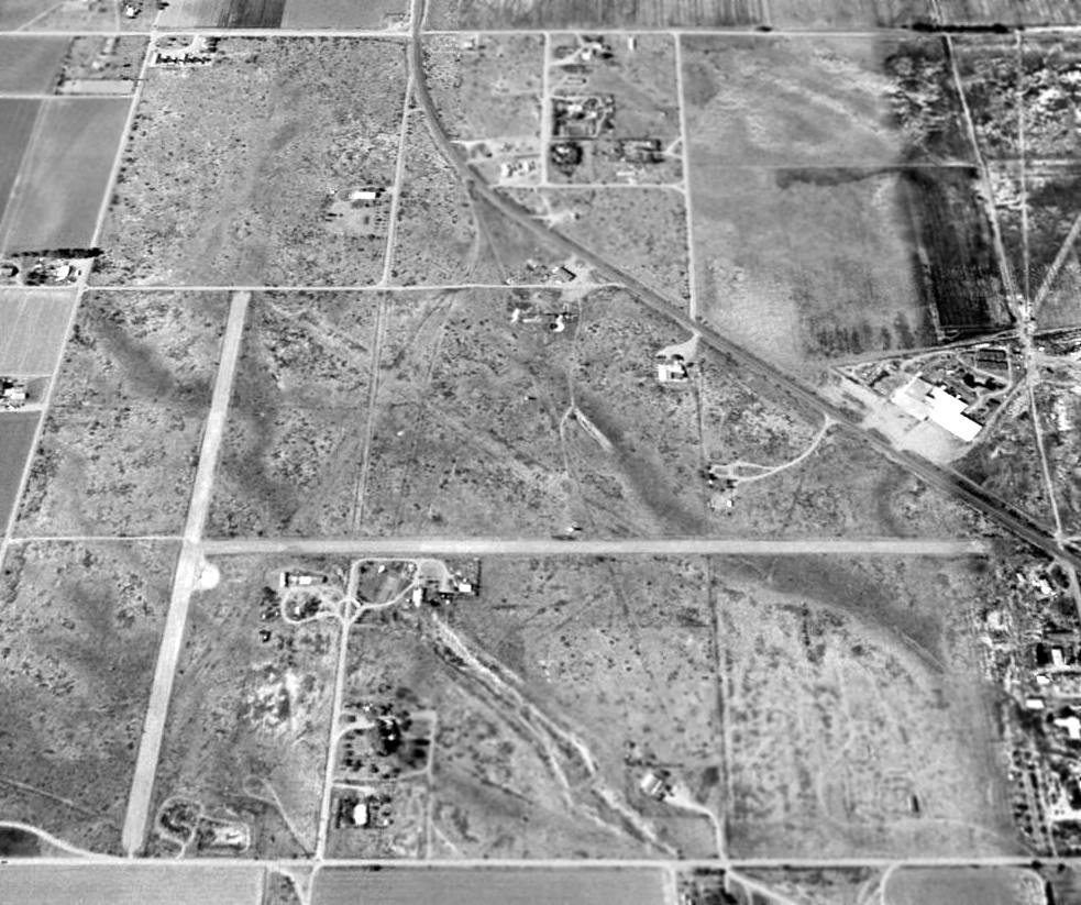
Turner Ridgeport Airport (NM72), Silver City, NM
32.75, -108.29 (Southwest of Albuquerque, NM)

Turner Ridgeport Airport, as depicted on the 1984-85 NM Aeronautical Chart (courtesy of Alex Hauzer).
According to a 1985 FAA Airport/Facility Directory entry, Turner Ridgeport Airport was established on 9/1/71.
The earliest depiction which has been located of Turner Ridgeport Airport was on the 1984-85 NM Aeronautical Chart (courtesy of Alex Hauzer).
It depicted Turner Ridgeport as having a 4,000' paved Runway 15/33 & a 2,400' gravel Runway 8/26.
As of 1985, Turner Rudgeport was a private airfield, owned by Grant City Flying Service, and managed by William Turner.
It had 2 runways: a 4,000' asphalt Runway 15/33 & a 2,400' soil Runway 8/26.
The airport was said to have 2 based aircraft: 1 multi-engine aircraft & 1 ultra-light aircraft.

The last aeronautical chart depiction which has been located of Turner Ridgeport Airport
was on the 1990-91 NM Aeronautical Chart (courtesy of Alex Hauzer).
It depicted Turner Ridgeport as a private airfield having a single north/south 4,000' paved runway.

The 1992 USGS topo map depicted Turner Ridgeport Airport as having a single paved northwest/southeast runway, with 3 small buildings on the northeast side.

The earliest photo which has been located of Turner Ridgeport Airport was a 10/7/97 USGS aerial view looking southeast.
It depicted Turner Ridgeport's single paved runway (on the right), with a ramp with a few small buildings on the north side (in the foreground).
There were no aircraft visible, or any other sign of recent aviation usage.
However, the photo also appeared to depict 2 other unpaved runways on the east side (left of the airport):
were these runways that predated the paved runway?

A 7/25/11 aerial view looking southeast at Turner Ridgeport Airport showed it to remain intact, although evidently abandoned.
The remains of the other possible runways to the east also remained recognizable.
The date of closure of Turner Ridgeport Airport has not been determined.
It was depicted as an abandoned airfield on the 2012 Sectional Chart.
It was presumably closed due to competition from the Whiskey Creek Airport, located only 5 miles to the east.
The site of Turner Ridgeport Airport is located southwest of the intersection of Route 90 & Truck Bypass Road.
______________________________________________________
Rodeo Intermediate Field / Rodeo Airport, Rodeo, NM
31.93 North / 108.99 West (Northwest of El Paso, TX)

Rodeo Airport, as depicted on the September 1942 Douglas Sectional Chart (courtesy of Chris Kennedy).
The Rodeo Intermediate Field was evidently established as one of the Department of Commerce's network of Intermediate Fields,
which were constructed in the 1920s & 1930s to serve as emergency landing fields
along commercial airways between major cities.
The date of construction of the Rodeo Intermediate Field has not been determined.
The earliest reference to the field which has been located
was its listing in the 1934 Department of Commerce Airway Bulletin (according to David Brooks).
It described Rodeo Intermediate Field as the Department of Commerce's Site 57A.
It described the field as having 2 dirt: 3,950' east/west & 3,140' north/south.
The 1/1/36 Department of Commerce Airway Bulletin (courtesy of Bruce Thompson)
described Rodeo Intermediate Field as the Department of Commerce's Site 57A
along the San Diego – El Paso Airway.
It described the field as an irregularly-shaped sod field
containing 2 runways: 3,950' east/west & 3,140' north/south.
The field was said to have a rotating beacon, and boundary & approach lights.
A shed was said to be marked with “57A SD-El P.”
Bruce observed, “It is interesting to note that the coordinates listed in the facility directory
are incorrect & place the field in the mountains to the west.”
The earliest aeronautical chart depiction which has been located of the Rodeo Airport
was on the September 1942 Douglas Sectional Chart (courtesy of Chris Kennedy).
It depicted Rodeo as Site 26A.
It also depicted the adjacent Rodeo Radio beacon,
but indicated “Radio Range Inoperative Until Further Notice.”

The only photo which has been located showing Rodeo Intermediate Field while in operation
was a circa 1942-45 aerial view looking north from the 1945 AAF Airfield Directory (courtesy of Scott Murdock).
It depicted Rodeo Intermediate Field as an unpaved irregularly-shaped landing area.
The 1945 AAF Airfield Directory (courtesy of Scott Murdock) described Rodeo Intermediate Field
as a 140 acre L-shaped property field having 2 bare runways, measuring 3,950' east/west & 3,140' north/south.
The field was not said to have any hangars,
but was said to be illuminated with a rotating beacon, course lights, obstacle lights, boundary lights, and range lights.
The airfield was described as being owned by the U.S. Government & the State of NM, and operated by the Civil Aeronautics Administration.
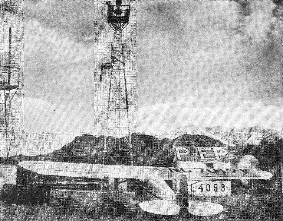
An undated photo of a Piper Cub in front of the Rodeo radio tower & shack, from a June 1947 Skyways Magazine article (courtesy of Jerry Sorrell).
Jerry reported, “According to the article, the Cub in the photo is new, and is on a ferry trip from the Piper factory in Lock Haven PA to E Monte CA.”

The January 1949 Douglas Sectional Chart (courtesy of Chris Kennedy) depicted “Rodeo (CAA)” as Site 26A,
having a 4,000' unpaved runway.
It also depicted the adjacent Rodeo Radio beacon.
The last aeronautical chart depiction which has been located of the Rodeo Airport
was on the 1953 Douglas Sectional Chart (according to David Brooks).
It depicted Rodeo as Site 26B, with 2 unpaved runways, the longest being 3,950'.
The Rodeo Airport was evidently abandoned at some point between 1953-54,
as it was no longer depicted on the September 1954 Douglas Sectional Chart (according to Chris Kennedy).
Intermediate Fields had largely become superfluous with advances in the range & reliability of commercial aircraft.

The last map depiction which has been located of the Rodeo Intermediate Field was on the 1955 USGS topo map.
It labeled the airfield as “Rodeo (CAA)”.
Nothing was depicted at the site of Rodeo Intermediate Field on the 1982 USGS topo map.

A December 25, 2006 aerial view still showed the recognizable outline of the 2 runways at the site of Rodeo Intermediate Field.
A February 2007 aerial view by Bruce Thompson looking east at the arrow & building remains at the site of Rodeo Intermediate Field.
![]()
A February 2007 photo by Bruce Thompson of Rodeo's former airmail route directional arrow.
Steve Owen noted, “The hill in the middle-distance that the arrow points directly to is the site of Airway Beacon 26B.”

A February 2007 photo by Bruce Thompson of the water tank foundation at Rodeo.
According to Bruce Thompson, “Broken [airfield lighting] fixtures can be found in a dump across the road from the airfield.”
A 2010 photo by Bruce Thompson “of the old radio building from Rodeo Intermediate field.
Apparently the building was moved into town after the airfield was shut down. It is now part of Rodeo Cottages.
The airway designation is still visible on the roof on the backside of the building & it says 'Rodeo' on the front.
The backside reads 'SD-EP 26A'.”
Veronica Straus reported in 2011, “I own the Rodeo Cottages. The large cottage was the radio shack.
When I remodeled it, I didn't want to change anything historic so I contacted a wonderful local historian, Junior Gomez,
and asked him to come & look at it before I put in a new floor & re-did the kitchen.
He told me that he had stayed there as a young boy scout during a rain storm.
They were camped on the airfield & the radio operator took pity on them & let them sleep inside the radio shack.
A hutch is built into the wall in the kitchen & I didn't remove it.
Junior says that the bedrooms had twin beds for the pilots & the hutch was always filled with coffee, peanut butter & bread.
When I ripped up the carpet, there was a linoleum floor
and in the middle of the room there was a 5'x7' square of brown linoleum with a lot of holes drilled through the floor.
Junior said that that was where the massive radio was located. No PC's then.
The small cottage was the Supply Depot. It had a bathroom & a wood stove in it.”
The site of Rodeo Intermediate Field is located northeast of the intersection of Route 9 & Route 80.
______________________________________________________
Columbus Airport, Columbus, NM
31.82 North / 107.63 West (West of El Paso, TX)

Columbus Intermediate Field, as depicted on a 1/16/42 aerial view looking north
from the 1945 AAF Airfield Directory (courtesy of Scott Murdock).
The Columbus Airport adjacent to the southeast side of the town
was evidently established as one of the Department of Commerce's network of Intermediate Fields,
which were constructed in the 1920s & 1930s to serve as emergency landing fields
along commercial airways between major cities.
The date of construction of the Columbus Airport has not been determined.
The earliest reference to the field which has been located
was in the 1931 Descriptions of Airports & Landing Fields (according to David Brooks).
The Airport Directory Company's 1933 Airports Directory (courtesy of Chris Kennedy)
described Columbus Airport as a Department of Commerce Intermediate Field,
Site 65 along the San Diego - El Paso Airway.
It was said to have 2 sod runways: 3,610; east/west & 2,628' north/south.
The field was said to have a rotating beacon, but to offer no services.
The earliest depiction which has been located of Columbus Intermediate Field
was a 1/16/42 aerial view looking north from the 1945 AAF Airfield Directory (courtesy of Scott Murdock).
It depicted Columbus Intermediate Field as an unpaved irregularly-shaped landing area.

The earliest aeronautical chart depiction of the Columbus Airport which has been located
was on the January 1944 El Paso Sectional Chart (courtesy of Chris Kennedy).
The field's designation had apparently changed at some point between 1933-44,
as the 1944 Sectional labeled it as Site 34.
The 1945 AAF Airfield Directory (courtesy of Scott Murdock) described Columbus Intermediate Field
as a 114 acre triangular property field having a bare all-way landing area, measuring 3,610' east/west & 2,610' north/south.
The field was not said to have any hangars,
but was said to be illuminated with a rotating beacon, course, obstacle, boundary, landing strip, and range lights.
The airfield was described as being owned by private interests, and operated by the Civil Aeronautics Administration.
Cy Martin recalled, “My family traveled that area with my dad when he was Assistant Airways Engineer back during WWII.
The terminal building at Columbus was a communication & weather station.
The metal building contained 2 diesel powered generators.
There was no commercial power available in the town although all the buildings were wired for electricity.
Apparently the mom & pop company went belly-up during the depression.
After the war, the area got REA juice.”

The 1960 Jeppesen Airway Manual (courtesy of Chris Kennedy)
depicted Columbus Airport as having a 4,210' Runway 8/26 & a 2,160' Runway 17/35.
A few small buildings were depicted on the northwest side of the field.
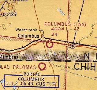
The August 1964 El Paso Sectional Chart (courtesy of Chris Kennedy)
depicted the "Columbus (FAA)" airport as having a 4,200' unpaved runway.

The 1965 USGS topo map depicted the outline of the airport, simply labeled as a "Landing Area".
A surveying marker named "Colair" was depicted at the location of the former airport beacon.
In 1965 it was transitioned over to the City of Columbus and it became Columbus Municipal Airport (according to David Brooks).
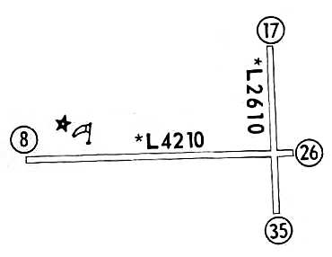
The 1967 Flight Guide (courtesy of Chris Kennedy)
depicted Columbus Airport as having a 4,210' Runway 8/26 & a 2,160' Runway 17/35.

The status of the Columbus Airport evidently changed at some point between 1967-76 to that of a private field,
as that is how it was depicted on the July 1976 CG-19 World Aeronautical Chart (courtesy of Chris Kennedy).
The 1976 AOPA Airports USA directory (according to Chris Kennedy)
described Columbus Municipal as having a single 4,210' gravel Runway 8/26.

The 1991 USGS topo map still depicted the outline of the former airport,
now simply labeled as a "Landing Area".
A surveying marker named "Colair" was depicted at the location of the former airport beacon.
The last chart depiction which has been located of Columbus as an active airfield
was on the 1994 CG-19 World Aeronautical Chart (according to David Brooks).

The distinctive outline of the Columbus Airport was still very much apparent in the 1996 USGS aerial photo.
It does not appear as if any buildings or the beacon tower remain standing, though.
Columbus Airport was evidently closed at some point between 1994-98,
as it was no longer depicted at all on the 1998 World Aeronautical Chart.
Vicki Engle reported in 2005, “the Federal Government closed the Columbus runways
because they were being used by drug smugglers.
The tower, minus the beacon (which has been misplaced or stolen),
is located at the Columbus Historical Society Museum - not yet erected, but awaiting funds to do so.”
A 2005 photo by Clifford Bossie of a light cone & boundary markers at the site of Columbus Airport.
Clifford reported, “Coming in from the East I could see a boundary (or perimeter) light cone & marker from NM Highway 9.
There is a North-South road that runs along the Eastern edge of the field,
so I turned onto that and drove down to the NE corner of the field.
There are still boundary markers and light cones marking the perimeter of the field,
but the field itself is pretty well overgrown with mesquite, sage & other vegetation.
I seriously doubt that it was active as recently as 1994.
The rutted dirt road running inside the Northern boundary was in better shape than the runways
and it has been many years since it has seen a grader.”

A 2005 photo by Clifford Bossie of what appears to be the foundation of the former terminal building.
Clifford noted, “Following that road to the West I came to the location of where the airport buildings had been located.
There are two foundations there, one large one that most likely had been what would have passed for the terminal
and the other was most likely where the generator and/or utilities were located
(the airport is located close enough to town that utilities might very well have come from the same sources as the town
and the generator might have been for emergency use).
This last foundation had several pipes sticking up which were most likely conduits for wiring.”
![]()
A 2005 photo by Clifford Bossie of the former airmail route directional arrow.
Clifford reported, “There was also a base for the beacon tower & an arrow that pointed along the airway route;
both being red & the arrow had a survey marker embedded into it.
I could not find any evidence of hangars & the area around the foundations is choked with weeds & grass.”

A 2005 photo by Clifford Bossie, of a “fair-sized metal building at the museum that looks to be a candidate
for the one that housed the generator & any other ancillary equipment.”

A 2005 photo by Clifford Bossie of the former Columbus Airport tower & beacon,
which was relocated at some point to the nearby Columbus Historical Society Museum.
Clifford noted, “all of the glass is broken out of the beacon itself.”
The site of Columbus Airport is located southeast of the intersection of Route 9 & Kansas Street.
______________________________________________________
Mount Riley Intermediate Field, Mount Riley, NM
31.8 North / 107.07 West (West of El Paso, TX)

An undated photo of an airway beacon (believed to be Mount Riley) from a May 1932 Kohler Generator newsletter (courtesy of Steve Owen).
This remote airfield located along the Mexican border
was built as one of the Department of Commerce's network of Intermediate Fields,
which were constructed in the 1930s along airways in between major cities
for the emergency use of commercial aircraft.
The date of construction of the Mount Riley airfield has not been determined.
The earliest depiction to be (possibly) located of the Mt. Riley CAA airway beacon
was an undated photo (believed to be Mount Riley) from a May 1932 Kohler Generator newsletter (courtesy of Steve Owen).
The earliest reference to the Mt. Riley Intermediate Field which has been located
was in the 1934 Department of Commerce Airfield Directory (according to Chris Kennedy),
which described Mount Riley as Site 68 along the San Diego - El Paso airway.
It was said to have three sod runways in an "L" shape, with the longest being the 3,600' east/west strip.
The designation of the field had apparently changed within the next few years,
as the Airport Directory Company's 1938 Airfield Directory (according to Chris Kennedy)
listed Mount Riley as Site 37 along the Phoenix - El Paso airway.

"Mount Riley (CAA)" was still depicted as an active airfield on the 1949 El Paso Sectional Chart (courtesy of Chris Kennedy).
The airfield was not depicted at all on the 1951 USGS topo map.
The Mount Riley Intermediate Field was apparently closed at some point between 1949-62,
as it was not listed in the 1962 AOPA Airport Directory.
The airfield was not depicted at all on USGS topo maps from 1974 or 1981.

However, the cleared area of the airfield was depicted (although not labeled) on the 1985 USGS topo map.

As seen in the 1996 USGS aerial photo,
the desert climate & lack of development in the southwestern US
generally results in a former airfield still remaining in a remarkably intact state of preservation,
and that is the case with Mount Riley.
The outline of the 3 former runways is still completely recognizable,
as the land within the former airfield remains noticeably more clear of scrub than the surrounding property.
There are no traces of any former buildings at the site.
Lloyd Sumner reported in 2004, "I first discovered this airstrip a couple of years ago
by looking at an aerial photograph of the area.
I noticed an unusual pattern in the desert that looked like an airstrip to me.
I have been in this area many times before & never saw anything resembling an airfield.
My curiosity got the best of me & I drove out to the site to look around.
I followed a primitive road heading south from the old town of Mount Riley,
a ghost town along the abandoned El Paso & Southwestern Railroad.
Off this road is a side road almost totally overgrown with shrubs
and no indication that anyone has traveled that road in many years.
About 100 yards down the road I came to the northern point of the north/south runway & parked the truck."
Lloyd continued, "After walking around for a bit,
I found a concrete foundation painted red with angle iron set in the concrete & cut off at ground level.
This used to be the base of a beacon tower.
I also found several pieces of broken concrete, also painted red.
Piecing these together, they form a huge arrow, once used to point out the direction of the air route.
A few other concrete foundations were in the immediate area,
including what looked like a foundation to a generator house.
Many tin oilcans, part to an old 4-cylinder engine & other rubbish were strewn around the surrounding desert."
Lloyd continued, "I walked around south along the north/south runway
and noticed that about every 100 yards were a series of short poles,
similar to a fence post were set in the ground.
There were about 10 of these poles set about 20 feet apart.
Another 100 yards down the runway was another series of these poles.
This continued all the way around the perimeter of the airfield.
In the surrounding desert around each of these series of poles I found several old light bulbs (25 watt Westinghouse).
At the south end of the north/south runway I found several empty 55 gallon drums."
Lloyd continued, "I also found the site of one of the navigation beacons used to mark this airway.
It is on a hill about 10 miles west of the Mount Riley airstrip.
The beacon is on top of a 50-foot hill.
The foundation of the beacon tower is identical to the foundation I found at the Mount Riley airstrip.
At the base of the hill is a stone structure with concrete mounting blocks
that apparently used to secure a gasoline motor & generator.
In the side of the hill are several telephone poles were once used to carry the electrical wires to the tower.
All sorts of rubble, broken light bulbs, fuse blocks, wires, etc. can be found at the top of the hill.
Portions of a concrete arrow are near the generator house at the bottom of the hill."
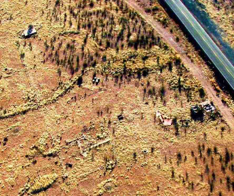
Clifford Bossie visited the site of the Mt. Riley Airfield in 2005.
He reported: “From the air the outline is clear, but from the ground it is a lot harder to find.
It appears that when the field was 'graded' the grading did little more than remove the vegetation.
It is by no means flat.
But I guess in the days it was built & aircraft reliability was an iffy proposition
it would look pretty good to a pilot in distress.
A landing there might damage the airplane, but there was a good probability of survival.”

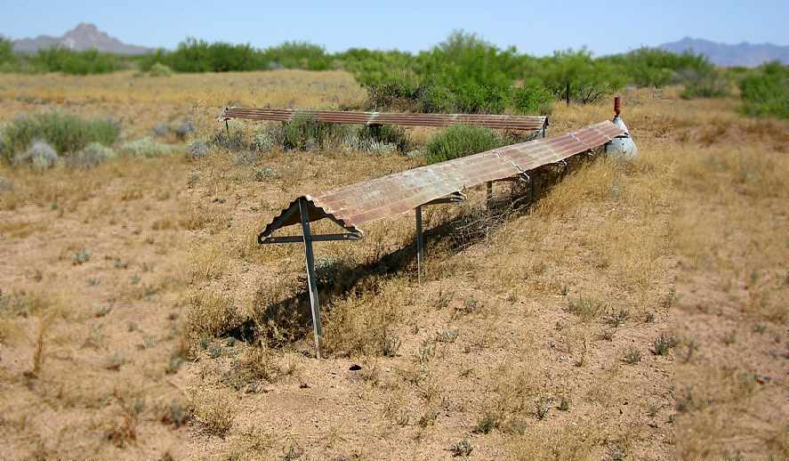
A 2005 photo by Clifford Bossie of the boundary posts at Mt. Riley.
According to Clifford, “The posts that Mr. Sumner describes in his text were to hold the field boundary markers.
It is possible that the light bulbs he mentions in his text were used to light those markers.
I found no evidence of any field lighting.
This was a very primitive field.
I suspect that the boundary markers were removed for scrap during WWII
and also suspect that the field had been long abandoned by then.”

A 2005 photo by Clifford Bossie of foundations at the site of the Mt. Riley Airfield.
Clifford continued, “The foundations on the Northeast corner of the field are still very noticeable,
and in fact that was the first indication that I had managed to reach the right location.
I would hazard a guess that the two large concrete block held the fuel tank(s),
the lower portion the generator shack,
and the red concrete pad still has the cutoff legs for the beacon as Mr. Sumner describes.
The red concrete is actually a thin layer of red colored (or dyed) concrete, not painted, layed on top of the beacon foundation.
The whole area around this foundation has had an outline of caliche rocks forming a box,
kind of like you used to see on Army bases around barracks.
There are a couple of smaller boxes that I can only guess the purpose of.
The air route navigation arrow is outside of this boxed area.”

A 2005 photo by Clifford Bossie of foundations at the site of the Mt. Riley Airfield.
Clifford continued, “The airfield is about 2-3 miles away from the Mt. Riley Railroad station
and about a mile South of NM Highway 9.
I do not think the airfield was manned around the clock, if at all.
There does not appear to have been any other structures than the area for the generator & beacon.
My personal belief is that any caretaker lived at the El Paso & South Western's Mt. Riley station,
or more likely that the railroad was contracted to maintain it.
I did not see any evidence of telephone poles,
so I don't know how a pilot making an emergency landing could contact anyone afterwards.
Radios were not all that common.”

A 2006 aerial photo by Clifford Bossie looking southeast at the remains of the former runways at Mt. Riley.

A 3/20/15 photo by Tony Rivera of the remains of the red concrete arrow at the site of the Mt. Riley Airfield.

A 3/20/15 photo by Tony Rivera of the site of the Mt. Riley Airfield.

A 3/20/15 photo by Tony Rivera of a USGS survey monument at the site of the Mt. Riley Airfield.
The site of Mount Riley Intermediate Field is located one mile southeast of the town of Mount Riley,
directly along the Mexican border.
Thanks to Chris Kennedy for pointing out this field.
______________________________________________________
Deming Auxiliary Army Airfield #1, Southwest of Deming, NM
32.02 North / 107.88 West (Northwest of El Paso, TX)

Deming Aux #1, as depicted on the February 1944 Roswell Sectional Chart (courtesy of Chris Kennedy).
Photo of the airfield while open has not been located.
This field was used during WW2 as one of 3 satellite airfields for Deming AAF (20 miles northeast),
which served as a training field for bombardiers & a base for target towing aircraft.
The Deming Auxiliary #1 Airfield was evidently established at some point between 1943-44,
as it was not yet depicted on the August 1943 Roswell Sectional Chart (according to Chris Kennedy).
The earliest depiction of the field which has been located
was on the February 1944 Roswell Sectional Chart (courtesy of Chris Kennedy).

Deming Aux #1 was still depicted as an auxiliary airfield on the 1945 Douglas Sectional Chart (courtesy of John Voss).

The Deming Aux #1 airfield was evidently reused as a civil airport at some point between 1945-49,
as that is how it was depicted, labeled "Deming (South)", on the 1949 Phoenix Sectional Chart (courtesy of Chris Kennedy).
It was described as having a 6,000' hard-surface runway.

The earliest photo which has been located of the Deming Aux #1 Airfield was a 12/9/62 aerial photo.
It depicted the airfield as consisting of a single east/west runway.
There do not appear to be any traces of any buildings at the site.
The airfield was not depicted at all (even as an abandoned airfield) on the 1967 USGS topo map,
or more recent aeronautical charts.

As seen in the 1996 USGS aerial photo,
the airfield consists of a single 6,200' east/west runway.
There do not appear to be any traces of any buildings at the site.
At some point before 1996 an installation of the Tethered Aerostat Radar System, Site B-42,
was built along Hermanas Road adjacent to the east side of the airfield,
visible as the circular pad just east of the runway.
The airspace over the aerostat is protected by a circular Restricted Area, R-5115.
______________________________________________________
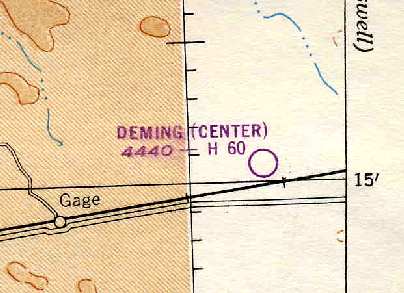
Deming Auxiliary Army Airfield #2, Gage, NM
32.26 North / 107.94 West (Northwest of El Paso, TX)

Deming Aux #2, as depicted on the February 1944 Roswell Sectional Chart (courtesy of Chris Kennedy).
Photo of the airfield while open has not been located.
This field was used during WW2 as one of 3 satellite airfields for Deming AAF (12 miles east),
which served as a training field for bombardiers & a base for target towing aircraft.
The Deming Auxiliary #2 Airfield was evidently established at some point between 1943-44,
as it was not yet depicted on the August 1943 Roswell Sectional Chart (according to Chris Kennedy).
The earliest depiction of the field which has been located
was on the February 1944 Roswell Sectional Chart (courtesy of Chris Kennedy).

Deming Aux #2 was still depicted as an auxiliary airfield on the 1945 Douglas Sectional Chart (courtesy of John Voss).
The Deming Aux #2 airfield was evidently reused as a civil airport at some point between 1945-49,
as that is how it was depicted, labeled "Deming (Center)", on the 1949 Phoenix Sectional Chart (courtesy of Chris Kennedy).
It was described as having a 6,000' hard-surface runway.
It was evidently closed at some point between 1949-58,
as nothing at all was depicted at the location on the 1958 Phoenix Sectional Chart (courtesy of Chris Kennedy).

The earliest photo which has been located of the Deming Aux #2 airfield was a 1962 USGS aerial view.
It depicted Deming Aux #2 as having a 5,800' east/west runway with a parallel taxiway on the north side.
There did not appear to be any remnants of any buildings.
The Deming Aux #2 airfield was labeled "Abandoned airport" on the 1968 Phoenix Sectional Chart (courtesy of Chris Kennedy).
It was simply labeled "Landing Strip" on the 1982 USGS topo map.

The 1991 USGS topo map depicted a single east/west runway, labeled simply as "Landing Strip".
It was not depicted at all (even as an abandoned airfield) on aeronautical charts from 1998 or 2003.

A 2003 photo looking southwest at Deming Aux #2 by Bill Suffa.
"I was climbing at about 8,000 feet when I took this picture.
I was climbing out of Deming, and picking up my IFR clearance as I spotted this field.
It lies just north of I-10, and almost directly under V-94, west of the Deming VOR.
It looks to have a lot of scrub on it, so I doubt it would be suitable for landing today."
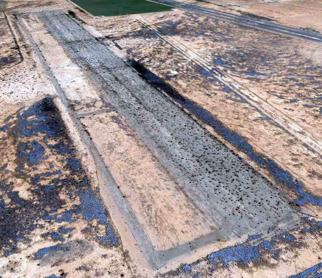
An 11/25/11 aerial view looking southeast shows the Deming Aux #2 airfield to remain intact though deteriorated.
The Deming Aux #2 Airfield is located on the north side of Interstate 10, eight miles east of Gage.
____________________________________________________
Since this site was first put on the web in 1999, its popularity has grown tremendously.
That has caused it to often exceed bandwidth limitations
set by the company which I pay to host it on the web.
If the total quantity of material on this site is to continue to grow,
it will require ever-increasing funding to pay its expenses.
Therefore, I request financial contributions from site visitors,
to help defray the increasing costs of the site
and ensure that it continues to be available & to grow.
What would you pay for a good aviation magazine, or a good aviation book?
Please consider a donation of an equivalent amount, at the least.
This site is not supported by commercial advertising –
it is purely supported by donations.
If you enjoy the site, and would like to make a financial contribution,
you
may use a credit card via
![]() ,
using one of 2 methods:
,
using one of 2 methods:
To make a one-time donation of an amount of your choice:
Or you can sign up for a $10 monthly subscription to help support the site on an ongoing basis:
Or if you prefer to contact me directly concerning a contribution (for a mailing address to send a check),
please contact me at: paulandterryfreeman@gmail.com
If you enjoy this web site, please support it with a financial contribution.
please contact me at: paulandterryfreeman@gmail.com
If you enjoy this web site, please support it with a financial contribution.
____________________________________________________
This site covers airfields in all 50 states.