Abandoned & Little-Known Airfields:
New York State: Buffalo area
© 2002, © 2016 by Paul Freeman. Revised 3/26/16.
This site covers airfields in all 50 states: Click here for the site's main menu.
____________________________________________________
Please consider a financial contribution to support the continued growth & operation of this site.
Amherst Airport (revised 8/17/14) - Angola Airport (revised 3/6/15) - County Line Airport (revised 3/6/15)
Fredonia Airport / Van Buren Flying Club (revised 3/30/14) - Goat Island Heliport (added 8/22/15) - Hamburg Airpark (added 2/3/15)
Olean Airport (revised 4/13/13) -Orchard Park Airport (revised 9/7/14) - Proner Airport (revised 3/14/16)
Sheridan Airport (added 9/12/15) - Original Wellsville Municipal Airport / Crowner Airport (revised 3/26/16)
____________________________________________________
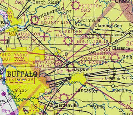
42.98 North / 78.71 West (Northeast of Buffalo International Airport, NY)
Sheridan Airport, as depicted on the December 1948 Detroit Sectional Chart (courtesy of Chris Kennedy).
This small general aviation airport on the northeast side of Buffalo was evidently established at some point between 1945-48,
as it was not yet listed among active airfields in the 1945 AAF Airfield Directory (courtesy of Scott Murdock).
The earliest depiction which has been located of Sheridan Airport was on the December 1948 Detroit Sectional Chart (courtesy of Chris Kennedy).
It depicted Sheridan as a commercial/municipal airport.

The 1948 USGS topo map depicted Sheridan Airport as having 2 unpaved runways, with a few small buildings on the south side.

The last aeronautical chart depiction which has been located of Sheridan Airport was on the November 1954 Detroit Sectional Chart (courtesy of Chris Kennedy).
It depicted Sheridan Airport as having a 2,400' unpaved runway.

The earliest photo which has been located of Sheridan Airport was a 6/3/58 USGS aerial view.
It depicted Sheridan Airport as having 2 unpaved runways.
Bob Heavener recalled, “A fellow had a gas station on the north side of Sheridan Drive near Transit Road.
He had a grass strip called Sheridan Airport, that was probably active in 1960.”

The last photo which has been located of Sheridan Airport was a 9/24/63 USGS aerial view.
It depicted Sheridan Airport as having 2 unpaved runways, with a few small buildings on the south end.
No aircraft were visible on the field.

The last depiction which has been located of Sheridan Airport was on the 1965 USGS topo map.
Sheridan Airport was evidently closed by 1966, as a 1966 USGS aerial photo showed residential construction covering the airport site,
the bane of general aviation airports all over the country.

A 2015 aerial view showed houses covering the site of Sheridan Airport.
The site of Sheridan Airport is located north of the intersection of Route 324 & Fruitwood Terrace.
Thanks to Bob Heavener for pointing out this airfield.
____________________________________________________
Goat Island Heliport, Niagara Falls, NY
43.08 North / 79.06 West (South of Buffalo, NY)

A 6/23/70 USGS aerial view of the Goat Island Heliport.
Jonathan Westerling reported, “The channel of the Niagara River splits in two above the falls, creating two sets of falls, one on either side of the island.
In 1959-60, the eastern side of the island was extended about 8 acres for additional parking & a helicopter pad.
Fill was provided from excavation for the construction of the Robert Moses State Parkway.
The waters immediately around Goat Island are relatively shallow & studded with islets & rocks, many of them scenes of dramatic rescues & rescue attempts.”
An article in a 1963 issue of the Niagara Falls Gazette (courtesy of Jonathan Westerling)
reported how Prior Aviation Service had been recommend to operate from a new private heliport on the east end of Goat Island.
Priot Aviation flew a Bell 47 helicopter from Goat Island giving tours, sanctioned by the State Park Service who owned the island.
The earliest depiction which has been located of the Goat Island Heliport was a 6/23/70 USGS aerial photo,
which depicted a yellow triangular helipad marking painted onto the south end of the parking lot on the east tip of Goat Island.

A still from a mid-1970s movie of a Bell 47 sightseeing helicopter making a stop at the Goat Island Heliport.

A still from a mid-1970s movie looking southwest from a helicopter on approach to the Goat Island Heliport.
The 1976 AOPA Airports USA (according to Jonathan Westerling) described the Goat Island Heliport as having a 50' x 75' asphalt landing area.
The 1979 AOPA Airports USA (according to Jonathan Westerling) described the Goat Island Heliport as having a slightly larger 100' x 75' asphalt landing area.
The Goat Island Heliport reportedly was closed at some point after 1983.

Amazingly a 2015 aerial photo still showed a barely-recognizable signature of the yellow triangular heliport marking at the site of the Goat Island Heliport,
between 2 light poles on the south end of the parking lot.
Thanks to Jonathan Westerling for pointing out this heliport.
____________________________________________________
42.75 North / 78.86 West (South of Buffalo, NY)

Hamburg Airpark, as depicted on the 1948 USGS topo map.
The date of establishment of this small general aviation airport has not been determined.
The earliest reference which has been located to Hamburg Airpark came from Tom Starr,
who recalled, “My dad & his parents found it by accident while traveling Route 20 during the 1930s.”
However Hamburg Airpark was yet depicted on the 1943 Detroit Sectional Chart (courtesy of Mike Keefe).
The earliest depiction which has been located of Hamburg Airpark was on the 1948 USGS topo map.
It depicted Hamburg Airpark as having a single northeast/southwest runway, with a few small buildings on the north side.

The earliest aeronautical chart depiction which has been located of Hamburg Airpark
was on the December 1948 Detroit Sectional Chart (courtesy of Chris Kennedy).
It depicted Hamburg as a commercial/municipal airport.

The last aeronautical chart depiction which has been located of Hamburg Airpark
was on the November 1954 Detroit Sectional Chart (courtesy of Chris Kennedy).
It depicted Hamburg as having a 2,200' paved runway, but being for Emergency use only.

The earliest photo which has been located of Hamburg Airpark was a 6/3/58 USGS aerial view.
Hamburg Airpark may have already been closed by this point, as there were no aircraft visible on the field, nor any other indication of recent aviation use.
One northeast/southeast unpaved runway was visible, with a few small buildings on the north side.

The last topo map depiction which has been located of Hamburg Airpark was on the 1960 USGS topo map.
It depicted Hamburg as a commercial/municipal airport.

The last photo which has been located of Hamburg Airpark was a 11/26/62 USGS aerial view.
Although the runway remained intact, there were no aircraft visible on the field, nor any other indication of recent aviation use.
Hamburg Airpark was evidently closed (for reasons unknown) at some point between 1960-64,
as it was no longer depicted on the 1964 Detroit Sectional Chart.
A 1995 aerial photo showed that a road & several buildings had been built over the site of Hamburg Airpark,
but one building (a former hangar?) remained standing, and traces of the runway were still recognizable.

A circa 2011 aerial view looking north showed one building (a former hangar?) remained standing on the north side of the Hamburg Airpark site.

A 2014 aerial view showed that the site of Hamburg Airpark was no longer recognizable as a former airport,
but one building (a former hangar?) remained standing on the north side of the property.
The site of Hamburg Airport is located south of the intersection of Route 20 & Route 75.
Thanks to Tom Starr for pointing out this airfield.
____________________________________________________
Amherst Airport, East Amherst, NY
43.06 North / 78.72 West (Northeast of Buffalo, NY)

Amherst Airport, as depicted on a 9/24/63 USGS aerial photo.
This small general aviation airport was evidently established at some point between 1958-62,
as only an open grass field was depicted at its location on a 1958 aerial photo,
and Amherst Airport was not yet depicted on the July 1947 Detroit Sectional Chart (courtesy of Dick Merrill).
The earliest reference which has been located to Amherst Airport came from Bob Heavener,
who recalled, “I learned to fly at Amherst Airport; I earned my private certificate while flying there in 1962.
I kept a Cessna 120 there from 1962-66. Frank Favale was the owner & operator of Amherst Airport.
Previously he operated at Audubon Airport.
The building on Millersport just Northeast of the 3 hangars was a restaurant with an aviation theme.
It was started by Fred Gage, a local radio personality.
Fred’s radio show featured episodes of Flaps Rickenbacker & his dog Fang.
Flaps flew an Edsel Tri Motor on the show.
At one time Fred acquired a wrecked Globe Swift, fitted it with 2 more engine mockups & displayed it outside of the 'Flaps' restaurant as the Edsel.
A World War One pilot named Don Coe had a mini aviation museum in the restaurant. Don had some interesting flying stories.”
The earliest depiction which has been located of Amherst Airport was on a 9/24/63 USGS aerial photo.
It depicted Amherst as having a single northeast/southwest unpaved runway.
A dozen light aircraft were parked around the west side of the field, along with 2 small hangars.

The 1965 USGS topo map depicted Amherst Airport as having a single unpaved northeast/southwest runway,
with a few small buildings on the west side.
Amherst Airport evidently gained a paved runway at some point between 1965-66,
as a 1966 aerial photo depicted the field as having a northeast/southwest paved runway just to the south of the original unpaved runway.
A dozen light aircraft were parked around the west side of the field, along with 2 small hangars.

The only aeronautical chart depiction which has been located of Amherst Airport
was on the July 1967 Detroit Sectional Chart (courtesy of Jonathan Hull).
It depicted Amherst as having a single northeast/southwest 2,300' paved runway.
The last depiction which has been located of Amherst Airport was on a 1972 aerial photo.
The number of aircraft visible on the field had markedly decreased since the 1966 photo,
with only 5 light aircraft parked outside.
Amherst Airport was evidently closed at some point between 1972-80,
as it was no longer depicted on the 1980 USGS topo map.
A 1995 USGS aerial photo showed that a composting facility had covered most of the runway of the former Amherst Airport.

A circa 2011 aerial view looking west at the remains of the western end of the Amherst runway,
with the remainder (at the top of photo) covered by a composting pile.

A circa 2011 aerial view looking south at what appears to be a former Art Deco airport office building along the west side of the site of Amherst Airport,
along with 2 former hangars at the top-right.
Chris Benke reported in 2013, “The Amherst runway is still there but in very poor shape & now serves as a Composting Center for the town.
I believe there still exists an Art Deco type terminal just off of Millersport Highway.”
The site of Amherst Airport is located east of the intersection of Route 263 & New Road.
____________________________________________________
Original Wellsville Municipal Airport / Crowner Airport, Wellsville, NY
42.12 North / 77.97 West (Southeast of Buffalo, NY)

A 5/19/38 photo (courtesy of Oak Duke) of a group of men in front of an unidentified biplane at the original Wellsville Municipal Airport,
on the occasion of the first air mail flight to Buffalo.
William Piper reported, “According to local history books,
the Wellsville Municipal Airport was established prior to 1938,
as the first air mail flight occurred on May 19th of that year to Buffalo.”
The earliest depiction which has been located of the original location of the Wellsville Municipal Airport
was a 5/19/38 photo (courtesy of Oak Duke) of a group of men in front of an unidentified biplane,
on the occasion of Wellsville's first air mail flight to Buffalo.

The earliest aeronautical chart depiction which has been located of the airport at Wellsville
was on the August 1939 Albany Sectional Chart (courtesy of Chris Kennedy).
It depicted the field “Crowner”, a commercial/municipal airport.
Crowner Airport was depicted on the 1950 USGS topo map.
The earliest photo which has been located depicting all of Crowner Airport was a 1952 aerial view.
It depicted Crowner as having 2 unpaved runways, with a single light plane parked near some small buildings on the southeast side.
The November 1956 Albany Sectional Chart (courtesy of Chris Kennedy)
depicted Crowner Airport as having a 2,300' unpaved runway.
Crowner Airport was still depicted on the 1958 USGS topo map.

The last photo which has been located depicting Crowner Airport still in operation was a 4/28/63 USGS aerial view.
It depicted Crowner as having a possibly-paved northwest/southeast runway, a short grass crosswind runway.
A total of 6 single-engine planes were visible parked near some small buildings on the southeast side.

At some point between 1956-64 the airfield was evidently renamed Wellsville Airport,
as that is how it was depicted on the July 1964 Albany Sectional Chart (courtesy of Chris Kennedy).
The field was described as having a 3,800' unpaved runway.

The 1965 USGS topo map depicted Wellsville Municipal Airport
as having 2 unpaved runways, with a few small buildings on the south & southeast sides.
Bob Heavner recalled, “I flew out of the old riverfront airport in Wellsville that was operated by Mote Tarantine in 1966.
Mote flew the 'Hump' in Burma during World War Two. The modern Wellsville Airport on the hill is named after him.”
William Piper recalled, “There was a single, paved runway extending northwest from Bolivar Road
and a smaller, southwest/northeast runway running parallel to the road.
Apparently, there were noise complaints & space limitations in the late 1960s due to building encroachment,
and a new site on a nearby hill was selected for the current Tarantine Field.
The new airport opened in November 1970, while the old Wellsville Municipal closed the next year after transitioning.”
The May 1971 Detroit Sectional Chart (courtesy of Chris Kennedy)
depicted the new Wellsville Airport to the southwest,
and depicted the original field as an abandoned airfield.
Even though the airport had been abandoned for 6 years,
the 1976 USGS topo map still depicted Wellsville Municipal Airport.
It depicted the field as having 2 unpaved runways, with a few small buildings on the south & southeast sides.
William Piper recalled, “My dad grew up in Wellsville & remembers that the old airport sat vacant & abandoned for many years.
The younger kids would ride their bikes down the main runway, while the older teens regularly held drag races with suped-up fastbacks.
Beginning around 1980, the stretch of Bolivar Road (Route 417) south of the main runway was commercially developed with a McDonald's, K-Mart, etc.
This completely destroyed any trace of the smaller, southwest/northeast runway,
the ramp area, and the southern-most portion of the remaining main runway.”

A circa 2007 aerial view looking east at the remaining pavement of the northwest end of the runway.

An August 30, 2007 aerial view showed the remaining pavement of the northwest/southeast runway.

A July 2008 photo by William Piper looking northwest from behind the TSC building of the remains of the paved northwest/southeast runway.
William Piper reported in 2010, “Today, the existing strip mall is centered around a Tractor Supply Company store, located at 480 Bolivar Road.
There is also a small roadway named 'Airway Drive' on the former property.
The remaining runway is surprisingly intact, considering that the facility closed nearly 40 years ago.
There have been plans recently, however, to build a Wal-Mart superstore on top of the existing remains of the old airport.”

A 3/21/16 photo by Jason Harry looking along the remains of the Crowner Airport paved runway.
Jason repored, “I've made numerous deliveries to a store in a shopping center adjacent to the old field.
Leaving after my first visit many moons ago, I noticed the screen of my GPS depicting what looked like a runway & sure enough, after some research, I was right.
It was amazing to me that the runway was still in decent shape.
I could land my Champ on it with no problems, I'd only need a very good excuse to hand to the authorities.
I consider it a great honor to have stood on some macadam I never had a chance to fly off only because I wasn't around at the time.
It likely won't be much longer until something more resourceful gets built on this piece of aviation history, so I am happy to have had the moment.
It was so quiet that you could almost hear the old radial engines & what not from back in the golden age.
With that sound were stories, most long gone from the spot where they were born, held in the heavens by the men & women who by now have likely flown west for good.”
____________________________________________________
County Line Airport, North Tonawanda, NY
43.04 North / 78.82 West (North of Buffalo, NY)

A 1945 advertisement promoting “Learn to Fly at the New County Line Airport” (courtesy of Mark Hess).
According to Mark Hess, “County Line Airport was officially opened in early April 1945 by George Graf.”
The earliest reference to County Line Airport which has been located was a 1945 advertisement
promoting “Learn to Fly at the New County Line Airport” (courtesy of Mark Hess).

The earliest aeronautical chart depiction which has been located of County Line Airport
was on the July 1947 Detroit Sectional Chart (courtesy of Dick Merrill).
It depicted County Line as a commercial/municipal field.

The earliest topo map depiction which has been located of County Line Airport
was on the 1948 USGS topo map (courtesy of Jonathan Hull).
It depicted County Line as having 2 runways, 3 taxiways,
and a single small building on the northwest side.

The earliest photo that has been located of County Line Airport
is a 1951 aerial photo (from the Erie County Public Works courtesy of Jonathan Hull).
It depicted the field as having 2 paved runways, 3 paved taxiways, and a paved ramp on the northwest side with a hangar
and 4 light single-engine planes.
The May 1957 Detroit Sectional Chart (courtesy of Jonathan Hull) depicted County Line as having a 2,000' runway.
The Aerodromes table listed County Line as having 2 turf runways, 80 octane fuel, and minor repair service.

A circa 1950s photo (courtesy of Jonathan Hull) depicted an unidentified taildragger (Aeronca?) in a hangar at County Line Airport.
The hangar markings show that the airport was by Bernie Aptheker
and that it served as the Headquarters for the TAK Squadron of the Buffalo Group of the Civil Air Patrol.
A 1958 aerial view depicted 9 aircraft at County Line Airport.

A 1961 advertisement for a Piper Cherokee airplane display at County Line Airport's Star Aviation Corporation (courtesy of Mark Hess).

The last photo which is available of County Line Airport was a 9/24/63 USGS aerial view.
It depicted the field as having 2 paved runways, 3 paved taxiways, and a paved ramp on the northwest side with a hangar
and 7 light single-engine planes.
According to Mark Hess, “During 1965, there were 2 competing airports nearby that got government funding whereas County Line Airport was left out.
County Line Airport was unable to improve/extend it's runways to get more business to generate revenue.
As a result, it was sold to a real estate developer for housing sometime after 1965.”
Signs of County Line Airport's impending demise were perceptible in a 1966 aerial photo.
Only a single plane was visible on the ramp outside the hangar,
and areas off the departure ends of the West and Northeast runways had been cleared,
presumably for the housing developments which would shortly replace the little airport.
The last aeronautical chart depiction which has been located of County Line Airport
was on the July 1967 Detroit Sectional Chart (courtesy of Jonathan Hull).
It depicted County Line as having a 2,300' runway.
The Aerodromes table described the field as having 2 turf runways, 80 octane fuel, and major repair service.
County Line Airport was evidently closed at some point between 1967-68,
as it was no longer depicted on the June 1968 Detroit Sectional Chart (according to Jonathan Hull).
A 1972 aerial view showed that a housing development had been built at some point between 1966-72 adjacent to the west side of the airport,
which otherwise appeared to remain intact.

A 1978 aerial photo showed the site of County Line Airport (from the University at Buffalo Map Libraries, courtesy of Jonathan Hull).
Jonathan observed, “The photo clearly showed the outline of the runways & an apparently intact hangar.
However, the encroachment from nearby development is also obvious.
Undoubtedly, this was a major cause for the demise of the airport.”
A 1995 aerial view showed the hangar still remained standing on the northwest side of the County Line Airport site.
A 2002 aerial view showed the hangar had been removed at some point between 1995-2002, with only the foundation remaining.

A circa 2007 aerial view looking south at the site of County Line Airport
shows the foundation of the hangar at bottom-right,
and the path of the northeast/southwest runway at top-left.

A June 2009 photo by Jonathan Hull “shows the view toward the departure end of the West runway.
The intersection of the crosswind runway can be seen in the distance.
A visit to the site by Jonathan Hull & Theodore Hull found that the area was recently cleared of brush
and graded, perhaps in anticipation of covering it with housing as was most likely the plan when the airport was closed more than 40 years ago.
However, traces of the airport can still be seen among the remains.”

A June 2009 photo by Jonathan Hull of “the hangar's concrete pad & the remains of indoor floor tiles at its southwest corner.
This was probably the airport office where Mr. Apthecker introduced aspiring pilots to the wonders of aviation.”

A 2014 aerial photo of the site of County Line Airport shows the majority of the property remains clear more than 46 years after the airport closed, inexplicably.
The hangar foundation also remains recognizable on the northwest side of the site.
The site of County Line Airport is located southeast of the intersection of Tonawanda Creek Road & East Summerset Lane.
Thanks to Jonathan Hull for pointing out this airfield.
____________________________________________________
Proner Airport, East Aurora, NY
42.8, -78.65 (Southeast of Buffalo, NY)

Proner Airport, as depicted on the 1948 USGS topo map.
This general aviation airport was evidently established at some point between 1943-48,
as it was not yet depicted on Detroit Sectional Charts from 1943, 1948, or 1949.
The earliest depiction of this field which has been located
was on the 1948 USGS topo map.
It depicted “Proner Airport” as having a single 1,400' unpaved east/west runway,
with a single building on the northwest side of the field.
Jim Birke recalled, “Proner Airport... I lived nearby.
When I was about 12, I helped guy repair the tail wheel on his Aeronca, I think it was the Champ model.
When I first saw him, I asked him if I could help him. He said 'Hand me a 9/16 combination wrench.'
Being a country boy, I knew what that was & handed him one. He said 'Yeah, you can help.'
After that, he'd let me know when he'd be at the field & we'd fix something or clean something.
For helping him he'd take me flying all over western NY in that little plane. Great experience for a young fella.”

A 1951 aerial view of Proner Airport (from the Erie County Department of Public Works, courtesy of Jonathan Westerling)
showed the field to have a single grass east/west runway, with a single hangar on the northwest side of the field.
A 1958 aerial view showed that several large buildings & parking lots had been built adjacent to the hangar on the northwest side of Proner Airport.

A circa 1958 photo by Jim Birke of the former Proner Airport hangar, visible behind a recently added industrial building.
Jim Birke noted, “This was a couple of years after Moog Valve took it over.
The hangar doors are still intact but, I don't think there were any aircraft hangared there at that time.”

The November 1954 Detroit Sectional Chart (courtesy of Chris Kennedy)
depicted Proner as having a 1,900' unpaved runway.
A 1966 aerial view depicted Proner Airport as having a single unpaved runway.

The last photo which has been located showing Proner Airport still largely intact was a 4/17/74 USGS aerial view.
It depicted Proner as having a single east/west unpaved runway, along with several buildings on the northwest side of the field.
There were no aircraft visible on the field, and it was not evident if it was still in operation at this point.

The 1995 USGS topo map depicted Proner Airport as having a single 2,800' east/west unpaved runway,
along with several buildings on the northwest side of the field.

However, a 1995 USGS aerial view looking northeast showed a very different story compared to the topo map from the same year:
the airport had been covered by buildings & parking lots,
with only the outline of the runway still barely recognizable.

A 2014 aerial view looking northeast showed only some short runway pavement portions remained at the site of Proner Airport.
The site of Proner Airport is located southeast of the intersection of Jamison Road & Seneca Street.
____________________________________________________
Orchard Park Airport (34D) / Orchard Park Army Airfield, Orchard Park, NY
42.8 North / 78.74 West (South of Buffalo, NY)

Orchard Park Airport, as depicted on the 1948 USGS topo map.
This general aviation airport was evidently established at some point between 1946-47,
as it was not yet depicted on the July 1946 Detroit Sectional Chart (according to Chris Kennedy).
The earliest depiction of this field which has been located
was on the December 1947 Detroit Sectional Chart (according to Chris Kennedy).
The 1948 USGS topo map depicted “Orchard Park Airport” as having a single 1,800' unpaved east/west runway,
with a single building on the north side of the field.

The June 1949 Detroit Sectional Chart
depicted Orchard Park Airport as having a 2,000' unpaved runway.

A 1951 aerial view of Orchard Park Airport (from the Erie County Department of Public Works, courtesy of Jonathan Westerling)
showed the field to have a single grass east/west runway.
What appeared to be a single light aircraft was visible parked on the north side of the field.

At some point between 1949-54, this little airfield was evidently taken over by the military,
as it was depicted as “Orchard Park (Army)” on the November 1954 Detroit Sectional Chart (courtesy of Chris Kennedy).
It was still depicted as “Orchard Park AAF” on the May 1957 Detroit Sectional Chart (according to Chris Kennedy).
A 1958 aerial view showed 4 light aircraft parked on the north side of the field.

The 1960 Jeppesen Airway Manual (courtesy of Chris Kennedy)
depicted “Orchard Park AAF” as consisting of a 1,950' grass Runway 10/28,
on the north side of which was superimposed a 1,500' steel mat (to be used under wet field conditions).
According to Ronald Ciura, “In September 1962 the New York Army National Guard had moved out the L-19s
and the field was operated by DAB Aviation.
In May 1963 a fire destroyed the hangar & several aircraft.”
Orchard Park was not listed among civilian airfields in the 1963 AOPA Airport Directory (according to Chris Kennedy).
On the July 1965 Detroit Sectional Chart (according to Chris Kennedy),
Orchard Park was listed as a private (civilian) airfield.
A 1966 aerial view showed 3 light aircraft parked on the north side of the field.

A circa 1965-75 photo by Henry Hunt, of “my Dad W.F. Hunt in front of the snowbound lounge (we just called it 'The Lounge' not the Operations Building).”
Henry Hunt recalled, “I spent the majority of my weekends from circa 1965-75 at the Orchard Park Airport.
My Dad W.F. Hunt & his brother George started with a Taylorcraft, then switched to a Stinson Voyager,
then bought an Airknocker, sold the Voyager to add an L-5 & eventually had a glider & banner towing business (the L-5 was perfect for this) under Blasdell Luftwaffe, Inc.
They also rented the Champ. At the end they sold those last 2 & the Corporation & bought the Citabria.
The [airport] manger of the time was Martin Reiman.”

A circa 1965-75 photo by Henry Hunt of a Stinson L-5 "Flying Grasshopper" picking up a banner at Orchard Park Airport.

A 1974 photo by Henry Hunt of a Stinson L-5 at Orchard Park Airport.
Henry Hunt recalled, “There was a chapter of the Civil Air Patrol based there.
My Dad (aka Bill, Red) persisted thru hoops of research, letter writing, even organizing an event with an official
and generally bull charging against being put off... to divert the L-5 from being 'scraped out' to Israel.
It was flown in fully operational. Somebody had hammer-tapped an under-wing inspection plate to mark it as scrap.”

A 1983 photo by Mike Zimmer of the operations shack of Orchard Park Airport,
with a pretty natural-metal Navion on the right.
Mike Zimmer recalled, “When on leave from Offutt AFB in the early 1980s,
I would get checked out on a C-172 from Orchard Park & take my dad for a ride.”

A 1983 photo by Mike Zimmer of several light single-engine aircraft in the tie-down area at Orchard Park Airport.
The 1982 AOPA Airports USA Directory (courtesy of Ed Drury)
described Orchard Park Airport as having a single 2,120' turf Runway 9/27.
The field was said to offer fuel, repairs, tiedowns, flight instruction, and plane rental.
The operator was listed as Quaker Flying Service, Inc.
The 1993 Jeppesen Airport Directory described Orchard Park Airport
as having a single 2,400' turf Runway 9/27.

The 1995 USGS topo map depicted Orchard Park Airport as having a single east/west unpaved runway,
and several buildings on the north side of the field.

Orchard Park Airport was still operational in 1995,
as the 1995 USGS aerial view looking southwest showed a total of 5 light single-engine aircraft visible parked on the field.

A 3/31/02 aerial view showed that Orchard Park Airport had been closed at some point after 1995,
as no aircraft were visible any longer on the field.

A closeup from the 3/31/02 aerial view showed that the former operations shack & hangar remained standing,
but the field was devoid of any aircraft.
Mike Zimmer reported in 2005, “Today I would estimate the western half of the field is now a shopping mall & apartment complex.
I know because my apartment building is part of that complex.”

A circa 2005 aerial view looking north at the former operations building, hangar, and ramp at the former Orchard Park Airport.

A 10/5/11 aerial view looking southwest at the remains of Orchard Park Airport.
The site of Orchard Park Airport is located at the southern terminus of Countryside Lane,
southeast of its intersection with Southwestern Boulevard.
____________________________________________________
Fredonia Airpark / Van Buren Flying Club Airport, Fredonia, NY
42.44 North / 79.4 West (Southwest of Buffalo, NY)

Fredonia Airpark, as depicted on the December 1947 Detroit Sectional Chart (courtesy of Chris Kennedy).
This general aviation airport was evidently established at some point between 1946-47,
as it was not yet depicted at all on the July 1946 Detroit Sectional Chart (according to Chris Kennedy).
The earliest depiction of this field which has been located
was on the December 1947 Detroit Sectional Chart (courtesy of Chris Kennedy).
It depicted Fredonia as a commercial/municipal airport.

The earliest photo which has been located of Fredonia Airport was a 5/10/53 USGS aerial view.
The field was depicted as having 2 paved perpendicular runways,
with a few small buildings to the northeast of the runway intersection.
No aircraft were visible parked outside.

The 1954 USGS topo map depicted Fredonia Airport as having a single unpaved east/west runway, with several small buildings along the north side.
Fredonia evidently gained a 2nd runway at some point between 1954-62,
as the 1962 AOPA Airport Directory described “Fredonia Airpark”
as having 2 gravel runways: 2,550' Runway 9/27 & 1,925' Runway 18/36.
The field was said to offer fuel, hangars, tiedowns, and charter.
The operator was listed as Fredonia Airpark, Inc.
Mike Zimmer recalled, “The height of activity was during the late 1950s to mid 1960s.”

The 1965 Jeppesen Airway Manual (courtesy of Chris Kennedy)
depicted Fredonia Airport as having two turf runways: 2,550' Runway 9/27 & 1,875' Runway 18/36.
A cluster of small buildings was depicted to the northeast of the runway intersection.
The manager was listed as A.J. Wahl.

A circa 1966-69 aerial view by Len Zimmer of Fredonia Airport (courtesy of Mike Zimmer).
The field was depicted as having a single paved runway,
along with a former crosswind runway which was already marked as being closed.
Several small hangars were depicted, along with about 20 light single-engine aircraft.

A circa 1966-69 aerial view by Len Zimmer of the Fredonia Airport office building (courtesy of Mike Zimmer).

A circa 1966-69 photo by Len Zimmer of the Dunkirk-Fredonia Civil Air Patrol squadron's Aeronca (courtesy of Mike Zimmer).
Mike Zimmer recalled, “My dad flew his Luscombe 8E from this field
as well as the Dunkirk-Fredonia Civil Air Patrol squadron's Aeronca.
For several years, the Red Wing food company in Fredonia
based it's corporate airplane (a Cessna 310) at this strip.”
The May 1971 Detroit Sectional Chart (courtesy of Chris Kennedy)
depicted Fredonia as a public-use airport having a 3,400' unpaved runway.

At some point between 1971-76, the field was evidently renamed the “Van Buren” Airport,
as that is how it was labeled on the December 1976 CF-18 World Aeronautical Chart (courtesy of Chris Kennedy).
The runways had also been significantly lengthened,
the field being described as having a 4,600' unpaved runway.
However, the status of the field had also changed to a private field.
The 1982 AOPA Airports USA Directory (courtesy of Ed Drury) described the “Van Buren Flying Club” Airport
as having two gravel runways: 4,650' Runway 9/27 & 2,850' Runway 18/36.
The status of the field was described as “Private. Closed to public.”
The 1986 USGS topo map still depicted two runways, but they were labeled simply as “Landing Strips”,
which may indicate that the airport was already closed by that point.
Mike Zimmer recalled, “I drove by the area about 15 years ago [1990] with my Dad.
All buildings were gone & there was major shrub growth along the road.
You could still glimpse the remains of a strip through the trees.”

The 1990 USGS topo map still depicted a single runway, but it was labeled simply as “Landing Strip”.

In the 1994 USGS aerial photo the majority of the property of the former Fredonia Airport had been covered by a landfill.
However, at least one of the former airport buildings appeared to remain,
and the western portion of the outline of the former runway was still recognizable as well.
Mike Zimmer reported in 2005, “I drove by the airfield last week and it is now a landfill site.”

A circa 2006 aerial view looking north at a former hangar & a portion of the remaining runway pavement at the site of Fredonia Airport.
The site of Fredonia Airport is located southeast of the intersection of Route 5 & Van Buren Road.
____________________________________________________
Angola Airport (D22), Angola, NY
42.66 North / 79 West (Southwest of Buffalo, NY)

Angola Airport was depicted simply as “Landing Strip” on the 1965 USGS topo map.
This small general aviation airport was evidently built at some point between 1958-65,
as it was not yet depicted on a 1958 aerial view.
The earliest depiction which has been located of Angola Airport was a 1963 aerial photo,
which depicted a single north/south unpaved runway with a single small hangar at the south end.
The 1965 USGS topo map depicted a single north/south unpaved runway, labeled simply as “Landing Strip”.
A 1966 aerial view depicted Angola Airport in the same configuration as seen in 1963,
but a single light aircraft was visible next to the hangar on the south side.
Angola Airport was not yet listed in the 1967 AOPA Airport Directory (according to Chris Kennedy).

The earliest aeronautical chart depiction of Angola Airport which has been located
was on the 1971 Detroit Sectional Chart (courtesy of Chris Kennedy),
which depicted "Angola Airways" as having a 3,000' unpaved runway.
The 1982 AOPA Airport Directory (courtesy of Ed Drury)
described "Angola Airways" Airport as having a 3,200' asphalt Runway 1/19 & a 2,550' gravel Runway 9/27.

The 1986 Flight Guide (courtesy of Chris Kennedy) depicted Angola Airways Airport
as having a 3,230' paved runway 1/19 & a 2,800 turf/gravel Runway 9/27,
as well as several small buildings on the southwest side of the Runway 1/19.
The 1993 Jeppesen Airport Directory depicted Angola Airport
as having a single 3,212' paved runway 1/19 & a 2,915 turf/gravel Runway 9/27,
as well as several small buildings on the southwest side of the Runway 1/19.
The operators were listed as Angola Aircraft Services & Premier Airways.

In the 1994 USGS aerial photo (taken while the field was still open),
a total of 5 light single-engine aircraft were visible on the field,
parked around a cluster of small buildings & hangars on the south end of the field.
The new ramp on the east side of the field was evidently under construction at this point.

Angola Airport was still listed in the 2001 AOPA Airport Directory.
The field was described as having a 3,212' asphalt Runway 1/19 & a 2,800' gravel Runway 9/27.
Dennis Sandow reported in 2003 that Angola had "a succession of owners who were more airplane lovers than businessmen.
I used to fly in there to visit my family nearby. Sometimes he had fuel, sometimes not.
If the office was closed, a sign on the door told you to call the owner at his (real) 9-5 job.
About 3-5 based aircraft, but no market."
According to the 2003 Annual Report of the NY Department of Transportation,
Angola Airport was one of two public use airports in NY which closed in 2002 (the other was Kamp).
"The operator of this airport declared bankruptcy & had a mortgage on the property;
the Town of Evans was not interested in purchasing the property with federal & state assistance."
According to Dennis Sandow, Angola Airport has "very awkward highway access & no sewers,
so it's not going to become a Wal-Mart or condos. Just abandoned."

A circa 2001-2005 aerial view looking north at the south end of Angola Airport's Runway 1/19
shows that the airport remained completely intact.
A closed-runway “X” symbol was visible on the runway,
and the hangars remained standing, on the southwest & east sides of the runway.
A 7/28/07 aerial view showed Angola Airport to remain largely intact.

A 2014 aerial view looking northwest showed Angola Airport to remain intact,
but the runway & ramps were being used to store hundreds of cars.
Angola Airport is located northwest of the intersection of Evans Center Road & Southwestern Boulevard.
____________________________________________________
42.17 North / 78.39 West (Southeast of Buffalo, NY)

Olean Airport, as depicted on the 1929 Rand-McNally Standard Map of NY with Air Trails (courtesy of Chris Kennedy).
The date of construction of this small general aviation airport has not been determined.
The earliest depiction of the Olean Airport which has been located
was on the 1929 Rand-McNally Standard Map of NY with Air Trails (courtesy of Chris Kennedy).
It described the "Olean Airport" as a commercial airport, operated by D. Murphy.
The field was said to be 50 acres in size, and to have a 1,500' runway.

A 1930 photo by Archibald Schuyler of several biplanes at Hinsdale (courtesy of Scott Schuyler).
The earliest photographic depiction of the airport in Hinsdale which has been located
was in a series of 1930 photos by Archibald Schuyler (courtesy of Scott Shuyler).
They depicted the airport as a grass airfield with a single arch-roof hangar & a small office building, adjacent to a gas station.
Several biplanes were depicted on the field.
Scott Schuyler reported that his grandfather, Archibald Schuyler,
"owned an Alexander Eaglerock Long Wing (NC3032) & flew from Hinsdale."


A 1931 photo by Archibald Schuyler of planes lined up at Hinsdale (courtesy of Scott Schuyler).
with the airport office visible in the background.

A 1932 aerial photo by Archibald Schuyler of the airport at Hinsdale (courtesy of Scott Schuyler),
and what appears to be the shadow of the airplane from which the photo was taken (bottom right).
Scott Schuyler reported that the logbook of his grandfather (Archibald Schuyler) had entries for Hinsdale up to 1933.
The Airport Directory Company's 1933 Airport Directory (courtesy of Chris Kennedy)
described the "Olean Airport" in Hinsdale as a commercial airport.
The sod field was said to be 50 acres in size, measuring 1,800' x 1,000'.
A hangar was said to have "Olean Airport Hinsdale NY" painted on the roof.
The 1934 Department of Commerce Airport Directory (courtesy of Chris Kennedy)
described the Olean Airport in the same fashion.
The Olean Airport evidently closed (for reasons unknown) at some point between 1934-37,
as it was no longer listed among active airfields in The Airport Directory Company's 1937 Airports Directory (courtesy of Bob Rambo)
nor depicted on the 1938 USGS topo map or subsequent aeronautical charts.
According to Sheila Brown, at some point before 1956 the Olean Airport office was
relocated about a quarter-mile northeast of the airport site, to the north side of Route 446.
Sheila recalled, “1956 is when we moved in.
The Office was moved to its current location and turned into 'The Glass House' for Mildred Booth’s business.
The Glass House windows were lined with shelving that held the delicate items for her business, 'Treasures, Trash and Trinkets'.”

As seen in the 1994 USGS aerial photo,
the site of Olean Airport no longer has any recognizable trace as a former airfield.
Interstate 86 has been built over the southern portion of the airfield site.

Scott Schuyler has annotated the 1994 USGS aerial photo,
showing the location of the former runway, hangar, and other elements of the former airport.
Scott Schuyler recalled from a visit to the site of Olean Airport in 2003, "The airport is currently a vacant field,
and partially used by the state to house snowplows & heavy equipment.
The house located next to the airport is still standing.
The gas station appeared to be standing in the USGS photo, but it is not there now.
All visible signs of the airfield are long gone."

A circa 2011-2013 photo looking north at the circa 1920s/1930s Olean Airport office,
relocated about a quarter-mile northeast of the airport site, to the north side of Route 446.
Sheila Brown reported in 2013, “I own an old building (we call it 'The Glass House')
[seen in the 1930 pictures] that used to be the office for the Olean Airport.
It is located just a little up the road from its original location in Hinsdale.
It must have been a dark color back in the early 1930s.
I only have ever known it painted white.
I want to DONATE this old building to some place that will save it as a part of AIRFIELD HISTORY.
It has most of the original glass.
The Glass House is covered with the lilac bushes.
Only the front part of the building is The Glass House – the back half was added on (meaning one of the 4 glass walls is now wood).
The front part has a few broken windows but the glass is original – with maybe a couple replacements.
The roof in the back half (not the glass half part) has a hole in it.
The Glass House part is a really nice piece of history that I just don’t want to end up in a dumpster.
My daughter-in-law begged me to keep it.
It really belongs with some historic preservation club – preferably aviation history.
I will be sad if I end up throwing this piece of history away.”
The site of Olean Airport is located northwest of the intersection of Interstate 86 & Route 16.
____________________________________________________
Consolidated Aircraft / Bell Airport / Tonawanda Airport, Tonawanda, NY
43 North / 78.9 West (North of Buffalo, NY)

"Consolidated Aircraft Airport", as depicted on a 1929 Department of Commerce Airway Bulletin (courtesy of Jonathan Hull).
This airport in the town of Tonawanda was the factory airfield for the Consolidated Aircraft Company,
and later served as an airfield for the Bell Aircraft Company.
According to Phil Warner, “I am in possession of document RL893 from the Tonawanda-Kenmore Historical Society.
This document states that Consolidated Airfield was built starting in 1928 (by Reuben Fleet, President)
per permits 2315 (7/31/28), 225 (6/4/29), 553 (4/16/30), and 2568 (5/27/37).”
The earliest depiction of this field which has been located
was on a 1929 Department of Commerce Airway Bulletin (courtesy of Jonathan Hull),
which depicted it under its original name of "Consolidated Aircraft Airport".
The Consolidated Aircraft Airport was depicted as having a single 1,500' cinder runway, oriented north/south,
which was located in a narrow plot of land in between Route 265 & the NY Central Railroad.
However, there were already apparently plans to expand the airfield,
as the airfield diagram also depicted an "L"-shaped 3,100' x 2,100' plot of land
on the opposite (western) side of the railroad,
which was labeled "Not available at the present time".
A single 80' x 60' metal hangar was located on the northeast side of the field,
and was marked "Consolidated Aircraft Airport".
Phil Warner reported that “The Consolidated Aircraft Field [was] where my father tested Fleet trainers.
He died as the result of a crash in 1936 while demonstrating Fleet trainers to the Mexican War Department.”
The Consolidated Aircraft Airport may have gone through a period of abandonment,
as no field at this location was listed among active airfields
in the Airport Directory Company's 1937 Airports Directory (courtesy of Bob Rambo).
According to Phil Warner, the airfield “was acquired by Bell Aircraft in 1937,
and by private owner, Dick Benson in 1938.
I'm not sure why Bell sold to a private owner, but I'm pretty sure it was because the runway wasn't big enough for the warplanes being developed
(Bell's Chief Designer Bob Woods had designed the P-30 pursuit plane, and was working on the Airacuda).
I imagine Bell moved to their Niagara Falls location.”

However the airfield was still labeled as "Bell" Airport on the October 1943 Detroit Sectional Chart (courtesy of Mike Keefe).
Bell had substantial aircraft manufacturing operations at several locations in the Buffalo area during WW2,
which produced thousands of aircraft (including the Bell P-39, P-63, and P-59 fighters).
The 1944 US Army/Navy Directory of Airfields (courtesy of Ken Mercer)
described Bell Airport as having a 3,600' hard-surfaced runway.
According to Phil Warner, “My friend & I spent many years there,
and we were witness to a great explosion in the hangar near Military Road that signaled the 'death knell' of the airport in the mid 1940s.
Bob & I (Bob was about 13 & I was about 11) had helped put planes away in the hangar the evening of the explosion.
We returned to our homes which were about a mile from the airport.
Around bedtime the tremendous explosion occurred.
The cause was determined to be a spark from the centrally-located furnace which shot out
and landed on large cans of dope (paint) which were stored next to the furnace so they wouldn't freeze in the cold weather.”
In 1946, Bell's manufacturing operations in Buffalo were idled by a crippling strike,
which would eventually be one factor which would combine to doom the company's continued presence in the Buffalo area.
The July 1947 Detroit Sectional Chart (courtesy of Dick Merrill) depicted Tonawanda Airport as a commercial/municipal field.

The most detailed depiction of Bell Airport which has been located was on the 1948 USGS topo map.
It showed the airport as having a single paved northeast/southwest runway,
with the curious design of having what appeared to be three turn-around areas:
one at each runway end as well as one in the middle of the runway.
Note that this runway on the west side of the railroad tracks replaced the earlier north/south runway on the east side of the tracks.
The only building depicted at the airfield was a single small building,
adjacent to the northeast end of the runway.

The last chart depiction of the airport which has been located
was on the June 1949 Detroit Sectional Chart (courtesy of Donald Felton),
which depicted "Tonawanda" as having a 3,000' hard-surface runway.
Although some sources indicate that Bell Airport was closed in 1952,
the aeronautical charts seem to indicate that the field was closed at some point within 1949,
as it was no longer depicted at all on the December 1949 Detroit Sectional Chart (courtesy of Mike Keefe)
or later charts.

A 1951 aerial photo of the Bell Airfield (from the Erie County Public Works, courtesy of Jonathan Hull).
The northeast/southwest runway on the west side of the railroad tracks was still visible,
but there was no remaining trace of the former north/south runway on the east side of the tracks.
There was no indication that the airfield was still active at that point.
By 1951, Bell announced that it was completely pulling out of Buffalo,
after receiving favorable offers from officials in TX (including assurances of a more favorable labor climate).
Bell eventually moved all of its operations to a new facility in Hurst, TX (in between Fort Worth & Dallas).

A 1966 aerial photo of the Bell Airfield (from the University at Buffalo Map Libraries, courtesy of Jonathan Hull).
Although the runway was still visible,
the middle of the airfield had been covered at some point between 1951-66 by several buildings.

As seen in the 1995 USGS aerial photo,
the site of Bell Airport had been bisected by Route 290,
and a large number of industrial buildings occupied most of the site.
There did not appear to be any remaining trace of the former airfield.
The site of Bell Airport is located northwest of the intersection of Route 265 & Esminger Road.
____________________________________________________
Since this site was first put on the web in 1999, its popularity has grown tremendously.
That has caused it to often exceed bandwidth limitations
set by the company which I pay to host it on the web.
If the total quantity of material on this site is to continue to grow,
it will require ever-increasing funding to pay its expenses.
Therefore, I request financial contributions from site visitors,
to help defray the increasing costs of the site
and ensure that it continues to be available & to grow.
What would you pay for a good aviation magazine, or a good aviation book?
Please consider a donation of an equivalent amount, at the least.
This site is not supported by commercial advertising –
it is purely supported by donations.
If you enjoy the site, and would like to make a financial contribution,
you
may use a credit card via
![]() ,
using one of 2 methods:
,
using one of 2 methods:
To make a one-time donation of an amount of your choice:
Or you can sign up for a $10 monthly subscription to help support the site on an ongoing basis:
Or if you prefer to contact me directly concerning a contribution (for a mailing address to send a check),
please contact me at: paulandterryfreeman@gmail.com
If you enjoy this web site, please support it with a financial contribution.
please contact me at: paulandterryfreeman@gmail.com
If you enjoy this web site, please support it with a financial contribution.
____________________________________________________
This site covers airfields in all 50 states.