Abandoned & Little-Known Airfields:
New York, Long Island, Eastern Suffolk County
© 2002, © 2016 by Paul Freeman. Revised 9/4/16.
This site covers airfields in all 50 states: Click here for the site's main menu.
____________________________________________________
Please consider a financial contribution to support the continued growth & operation of this site.
Coram Airport (revised 9/4/16) - Sayville Airport (revised 8/17/14) - New Sayville Airport (revised 8/17/14)
____________________________________________________
40.87, -72.99 (East of New York, NY)

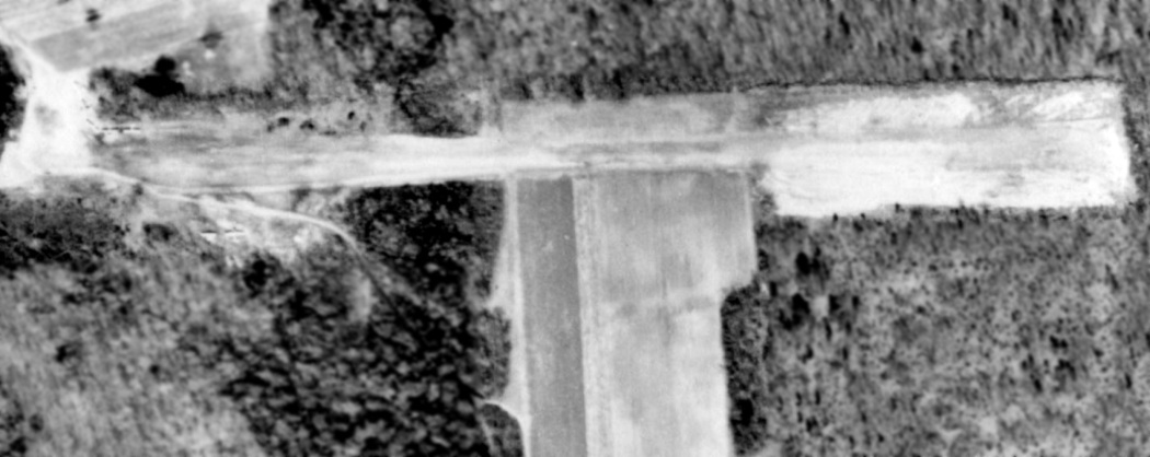
A 1962 aerial photo showed 6 single-engine aircraft parked northwest & southwest of the end of Coram's east/west runway.
No airfield was yet depicted at this location on a 1947 aerial photo.
This small general aviation airport adjacent to the east side of Coram was reportedly established in 1959,
and operated throughout its existence by Tom Murphy, a former military flight instructor & skywriter.
Tall trees at all runway ends reportedly made for interesting approaches.
The earliest depiction which has been located of Coram Airport was a 1962 aerial photo,
which showed 6 single-engine aircraft parked northwest & southwest of the end of Coram's unpaved east/west runway.
A 3/29/66 USGS aerial view of Coram Airport depicted 6 single-engine aircraft parked next to a small building
(described as a dilapidated pilot lounge / workshop) on the north side of an unpaved runway.

The earliest aeronautical chart depiction which has been located of Coram Airport
was on the 1967 NYC Local Aeronautical Chart.
It depicted Coram as a private field having a 2,200' unpaved runway.

The earliest topo map depiction which has been located of Coram Airport was on the 1967 USGS topo map.
It depicted Coram Airport as having a single unpaved east/west runway,
with a few small buildings on the northwest side.

A 1972 aerial view looking northwest depicted Coram Airport as having 2 dirt runways,
with a northeast/southwest runway having been added at some point between 1967-72.

The 1972 NYC Terminal Control Area Chart depicted Coram as a public-use airport having a 1,900' unpaved runway.
John Dolan recalled, “Coram: This dirt strip was still open in the 1970s when I started flying.”
Gordon Brown recalled, “Coram Airpark... an instructor who taught there had well over 20,000 hours.”

A 1978 aerial photo showed 6 single-engine aircraft parked on the northwest side of the end of Coram's east/west runway.
Christian Bobka recalled, “I also learned to fly out of the Coram Airport in the late 1970s.”
Ralph Fisch recalled, “I spent many, many hours of riding my bike to watch the Cubs & an old Cessna 172 (straight tail) operate out of Coram Airpark.
I can see it so clearly in my mind's eye, right down to the house with wings hanging in the rafters, and the smell of the oil, dope, stale coffee & cigarettes.”

A circa 1980 aerial view looking west along Coram's east/west runway.

A circa 1980 photo of a Piper Cub landing on Coram's south runway.
The June 1982 NY Sectional Chart (courtesy of Mitchell Hymowitz)
depicted Coram as a private airfield having a 1,900' unpaved runway.

The last topo map depiction which has been located of Coram Airport was on the 1984 USGS topo map.
It depicted a single east/west runway, labeled simply as “Landing Strip”.

The last photo which has been located showing an aircraft at Coram Airport was a circa 1985 photo of Joshua Stoff checking the oil of a Piper Cub.
Richard Hughes recalled, “Coram Airpark... was a grass strip. It was an ultralight field.”
A 1984 aerial photo showed Coram in the same configuration as seen in the 1978 aerial photo, but devoid of any aircraft.

The last aeronautical chart depiction which has been located of Coram Airport
was on the December 1986 NY Sectional Chart (courtesy of Kevin O'Reilly).
It depicted Coram as a private airfield having a 2,300' unpaved runway.
Bruno Schreck recalled, “I think I was the last guy to land & takeoff from Coram Airport, in a 'real' airplane in about 1989.
I dropped off a client there in my Cessna 172RG Cutlass. It [Coram Airport] still showed on current charts of the time.
And I had called the listed airport operator about 2 weeks before to ask permission & about conditions.
I landed to the northeast at about sundown & taxied to the northwest ramp.
There were several ultralight operators putting away their aircraft when I taxied up. Those ultralight pilots seemed totally shocked.
As it happens, the guy I had talked to came over, but he had either forgotten that I had inquired, or that I had a 'real' plane (or both).
Since it was around sundown, with no runway lights, I don't think I even shut down the engine. I just made my drop-off & taxied back for takeoff.
But my client was impressed that he didn't have to take the Long Island Express, and his wife probably still doesn't believe how he got home from the city via New Jersey.”

Coram Airport was evidently abandoned at some point between 1989-94,
as a 1994 USGS aerial view showed Coram's 2 runways remained intact though deteriorated.
Coram Airpark was no longer depicted on the May 2009 NY Terminal Aeronautical Chart.

A 3/6/12 aerial view looking southwest showed that Coram's 2 runways remain intact almost 30 years after the airport was abandoned.
Coram Airport is located southeast of the intersection of Middle Country Road & Mt. Sinai Coram Road.
____________________________________________________
Sayville Airport, Sayville, NY
40.752, -73.072 (East of New York, NY)

An 8/7/42 aerial view looking north at Sayville Airport
from the 1945 AAF Airfield Directory (courtesy of Scott Murdock).
This small general aviation airport was evidently established at some point between 1937-42,
as it was not yet listed among active airfields in The Airport Directory Company's 1937 Airport Directory (courtesy of Bob Rambo).
The earliest depiction which has been located of Sayville Airport
was an 8/7/42 aerial view looking north from the 1945 AAF Airfield Directory (courtesy of Scott Murdock).
It depicted Sayville Airport as an oval-shaped grass landing area with a single hangar at the north end.
The 1945 AAF Airfield Directory (courtesy of Scott Murdock) described Sayville Airport
as a 22 acre rectangular property having a 1,500' north/south all-way sod field.
Sayville was described as having 2 metal & wood hangars, measuring 50' x 50' & 40' x 25'.
The field was said to be owned by private interests,
but “Not in operation” (most likely due to wartime security restrictions on small civilian airports near the coasts).

The only aeronautical chart depiction which has been located of Sayville Airport was on the 1945 NY Sectional Chart,
which depicted Sayville as an auxiliary airfield.
According to Webb Morrison, “The Sayville Airport was established by Allen Thomas & Philomena Farrell in 1945
and they opened the Long Island School of Aeronautics which, for veterans, qualified under the GI Bill of Rights.
The airport also offered the standard services of hangar storage, tie downs, and repairs.”

The last photo which has been located of the original Sayville Airport was a 1947 aerial view.
It depicted Sayville Airport as an oval-shaped grass landing area with a single hangar at the north end.
No planes were visible on the field.
Charles Schnepp recalled, “Sayville Airport... I got my pilots license there in 1948.
It was a grass field with dirt runways & was located just a few miles south of McArthur Airport.
It was owned & operated by Al Thomas & Sis Farrell.
He was the instructor, she was the manager. They had no other employees.
65 years & 5,000 hours later, I will never forget them.”

The last depiction which has been located of the original Sayville Airport was on the 1949 USGS topo map,
which also depicted the replacement New Sayville Airport to the north.
The original Sayville Airport evidently closed (for reasons unknown) at some point between 1949-50,
as it was no longer depicted on the 1950 NY Sectional Chart,
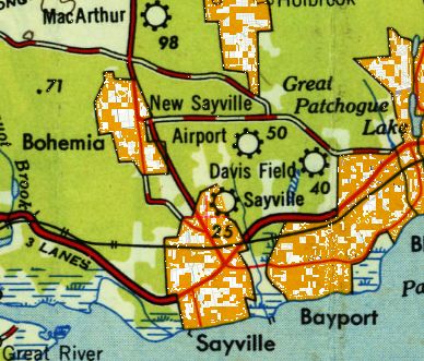
which instead depicted a “New Sayville” Airport a half-mile further south.
A 1954 aerial photo did not show any recognizable sign of the original Sayville Airport.

A 3/6/12 aerial photo did not show any remaining trace of the original Sayville Airport.
The site of Sayville Airport is located northwest of the intersection of Broadway Avenue & Montauk Highway.
____________________________________________________
New Sayville Airport, Sayville, NY
40.762, -73.072 (East of New York, NY)

A 1947 aerial view of New Sayville Airport.
According to the Sayville Library, “Application was made to establish an airfield in a Residential 'A' district in December 1941.
After approval, in 1945 the land was bought by Allan Thomas who, in partnership with Philomena 'Sis' Farrell, opened the Airport.
Allen - an ex-Air Force Captain, licensed as a flight instructor in multi-engine & airline transport training courses
as well as a licensed airline captain in his own right - established the Long Island School of Aeronautics, a flying school.
The first student was George Maklos, a bus driver from Patchogue.
By October, 63 students were receiving instruction in Piper Cubs or a Stinson V-77,
many under the GI Bill of Rights, and the airport had 6 T-shaped hangars.
Among students were local physician Peter Lerner & local lawyer George McInerney; McInerney entertained at one airshow with aerobatics in a biplane.
A second popular show act was 'The Flying Farmer' in which Thomas demonstrated what NOT to do in the air.
A third advertised attraction were passenger flights including 'Night Flights Over Sayville' at $2.50 each.
Beyond various levels of flight instruction, the airport also offered standard services of hangar storage, tie-downs and repairs.
Allan Thomas was also a frequent volunteer participant in air searches for missing persons (and bodies).”
This small general aviation airport replaced the original Sayville Airport located just a half-mile to the south.
The earliest depiction which has been located of New Sayville Airport was a 1947 aerial photo.
It depicted New Sayville as having 2 grass runways in an X-shape.
One single-engine aircraft & 6 individual T-hangars were visible on the southeast side.

The 1949 USGS topo map depicted both the New Sayville Airport & the predecessor Sayville Airport to the south.

The earliest aeronautical depiction which has been located of New Sayville Airport was on the 1950 NY Sectional Chart.
It depicted New Sayville as having a 3,000' unpaved runway.

A 4/7/54 aerial photo depicted New Sayville as having 2 grass runways in an X-shape.
A hangar, 7 individual T-hangars, and 4 single-engine aircraft were visible on the east side.

A Cessna T-50 Bamboo Bomber & another aircraft in the aftermath at New Sayville Airport from Hurricane Carol in September 1954.

Another view of the Cessna T-50 Bamboo Bomber in between some small buildings at New Sayville Airport after Hurricane Carol in September 1954.
According to Webb Morrison, “Unfortunately, Hurricane Carol in September 1954 destroyed both planes & hangars.
This - and also perhaps because of expanding services at nearby MacArthur [Airport] -
resulted in Thomas selling the 122 acres to developers in June 1955.
The Town returning the zoning to its original residential 'A' & the rest is history.”
Strangely, New Sayville Airport was not depicted at all on USGS topo maps from the 1950s or 1960s.
A 1961 aerial photo showed the abandoned New Sayville Airport,
with the 2 runways still remaining intact though deteriorated.
It appeared as if only the foundations remained of the hangar & T-hangars.
David Van Weele reported, “The landing field was removed probably in the early 1960s.
I worked on designing the housing development that is there now.
This is just south of Sayville Ford.”
A 1966 aerial photo showed houses covering the southern half of the airport site.
The northwest end of the runway remained recognizable, along with the foundation of the main hangar.
A 1969 aerial photo showed houses covering the remainder of the property,
erasing the last traces of New Sayville Airport.

A 3/6/12 aerial photo did not show any remaining trace of the New Sayville Airport.
The site of Sayville Airport is located southwest of the intersection of Broadway Avenue & Sunrise Highway.
____________________________________________________
Since this site was first put on the web in 1999, its popularity has grown tremendously.
That has caused it to often exceed bandwidth limitations
set by the company which I pay to host it on the web.
If the total quantity of material on this site is to continue to grow,
it will require ever-increasing funding to pay its expenses.
Therefore, I request financial contributions from site visitors,
to help defray the increasing costs of the site
and ensure that it continues to be available & to grow.
What would you pay for a good aviation magazine, or a good aviation book?
Please consider a donation of an equivalent amount, at the least.
This site is not supported by commercial advertising –
it is purely supported by donations.
If you enjoy the site, and would like to make a financial contribution,
you
may use a credit card via
![]() ,
using one of 2 methods:
,
using one of 2 methods:
To make a one-time donation of an amount of your choice:
Or you can sign up for a $10 monthly subscription to help support the site on an ongoing basis:
Or if you prefer to contact me directly concerning a contribution (for a mailing address to send a check),
please contact me at: paulandterryfreeman@gmail.com
If you enjoy this web site, please support it with a financial contribution.
please contact me at: paulandterryfreeman@gmail.com
If you enjoy this web site, please support it with a financial contribution.
____________________________________________________
This site covers airfields in all 50 states.