
Abandoned & Little-Known Airfields:
Northeastern New York State
© 2002, © 2016 by Paul Freeman. Revised 9/18/16.
This site covers airfields in all 50 states: Click here for the site's main menu.
____________________________________________________
Please consider a financial contribution to support the continued growth & operation of this site.
Plattsburgh Municipal Airport / Clinton County Airport (revised 8/30/15) - Riverside Airport (revised 9/18/16)
Ticonderoga Intermediate Field / Ticonderoga Airport (revised 7/17/15) - Utica Municipal (revised 10/18/15)
____________________________________________________
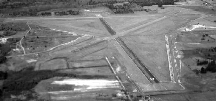
Ticonderoga Intermediate Field / (Original) Ticonderoga Airport, Ticonderoga, NY
43.89, -73.4 (Northeast of Albany, NY)
An 8/26/42 aerial view looking north at Ticonderoga Intermediate Field, from the 1945 AAF Airfield Directory (courtesy of Ernie Tobin).
The Ticonderoga Intermediate Field was not yet listed among active airfields
in The Airport Directory Company's 1937 Airports Directory (courtesy of Bob Rambo),
nor depicted on the January 1940 Albany Sectional Chart.
According to Ernie Tobin, Ticonderoga Intermediate Field was established in the early 1940s.
The earliest depiction which has been located of Ticonderoga Intermediate Field
was an 8/26/42 aerial view looking north from the 1945 AAF Airfield Directory (courtesy of Ernie Tobin).

A 10/13/42 USGS aerial view showed Ticonderoga Intermediate Field to have 2 grass runways with an airport circle marking at the intersection,
and some small buildings northeast of the runway intersection.
There were no aircraft visible on the field.
Ticonderoga Intermediate Field was listed in the 1944 Army/Navy Airfield Directory (according to Ernie Tobin)
and depicted on the 1944 & 1945 Albany Sectional Charts (according to Ernie Tobin).
The 1945 AAF Airfield Directory (courtesy of Ernie Tobin) described Ticonderoga Intermediate Field
as a 23 acre L-shaped property having 2 sod runways oriented in an L-shape,
measuring 3,200' west-northwest/east-southeast & 2,900' north-northwest/south-southeast.
The field was said to have 2 wood & metal hangars, the largest being 40' x 25'.
Ticonderoga was described as being operated by the Civil Aeronautics Administration & owned by private interests.

The earliest aeronautical chart depiction which has been located of Ticonderoga Intermediate Field
was on the May 1945 Albany Sectional Chart.
It depicted Ticonderoga Airport as also having CAA Airway Beacon #22.
Ticonderoga Intermediate Field was listed in the 1947 Haire Airport Directory (according to Ernie Tobin).
A 1947 aerial photo depicted Ticonderoga in the same manner as the 1942 photo.
Ticonderoga Intermediate Field was listed in the 1948 Haire Airport Directory (according to Ernie Tobin),
and was depicted on the 1949 Albany Sectional Chart (according to Ernie Tobin).

The 1950 USGS topo map depicted Ticonderoga Airport as having 2 unpaved runways & 2 small buildings northeast of the runway intersection.

The last aeronautical chart depiction which has been located of the original Ticonderoga Airport
was on the May 1960 Albany Sectional Chart.
It depicted Ticonderoga Airport as also having CAA Airway Beacon #22.
According to Ernie Tobin, the original Ticonderoga Airport operated “until the mid-1960s when the airport was sold to a paper company for a new mill.
No airport in Ticonderoga was depicted on the February 1970 Albany Sectional Chart.
The new Ticonderoga Municipal Airport opened just a mile to the southeast in October 1978, with a paved runway.
A 1994 USGS aerial photo showed that Shore Airport Road had been built
through the center of the original Ticonderoga Airport property at some point between the 1960s-1994.
A 10/8/11 aerial view showed the faintest traces of the outline of the 2 Ticonderoga grass runways.
![]()
A circa 2010 aerial view looking north at the historic circa 1942 airport beacon on the east side of the site of Ticonderoga Intermediate Field.
Ernie Tobin observed in 2013, “The only thing remaining on site is the old beacon light, but pieces of the old grass runways can still be seen from the air.
The beacon is one of my aviation causes.
It would be great to do something with it at the current airfield,
however the cost of dismantling, transporting, and restoration would be much more than one man could do.”
The site of Ticonderoga Intermediate Field is located east of the intersection of Adirondack Park Preserve & Shore Airport Road,
appropriately enough.
____________________________________________________
Plattsburgh Municipal Airport / Clinton County Airport, Plattsburgh, NY
44.69 North / 73.52 West (Northeast of Albany, NY)

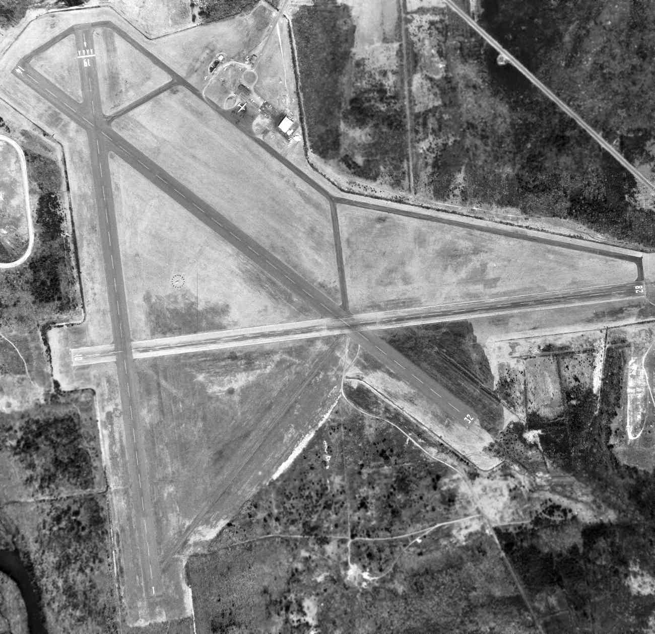
A circa 1943-45 aerial view looking north at Plattsburgh Municipal Airport, from the 1945 AAF Airfield Directory (courtesy of Scott Murdock).
No airfield was yet depicted at this location on the 1943 USGS topo map.
According to its FAA Airport/Facility Directory data, Plattsburgh Municipal Airport / Clinton County Airport was established in 1943.
The earliest depiction which has been located of Plattsburgh Municipal Airport
was a circa 1943-45 aerial view looking north from the 1945 AAF Airfield Directory (courtesy of Scott Murdock).
It depicted the field as having 3 paved runways, taxiways, and a ramp on the north side.
The 1945 AAF Airfield Directory (courtesy of Scott Murdock) described Plattsburgh Municipal Airport
as a 1,120 acre irregularly-shaped property having 3 asphalt 5,000 runways.
The field was said to have a single 60' x 52' wooden hangar under construction,
and to be owned by the City of Plattsburgh.
A 5/14/46 aerial view looking northwest at Clinton County Airport
showed the field to have 3 paved runways, taxiways, and 2 small buildings on the north side.
The 1957 USGS topo map depicted the Plattsburgh Municipal Airport as having 3 runways, taxiways,
and a small ramp with several small buildings & a beacon on the north side.

The earliest aeronautical chart depiction which has been located of Plattsburgh Municipal Airport
was on the April 1964 Burlington Sectional Chart.
It depicted Plattsburgh as having a 5,000' runway.
A 4/19/64 USGS aerial view of Plattsburgh Municipal Airport.

A closeup from the 4/19/64 USGS aerial photo depicted 7 aircraft on Plattsburgh's north ramp, including 6 single-engine aircraft & 1 larger twin-engine airliner (a Convair?).
The November 1966 Burlington Sectional Chart (courtesy of John Price)
depicted Plattsburgh Municipal Airport as having 3 paved runways, with the longest being 5,000'.

The 1966 USGS topo map depicted the Plattsburgh Municipal Airport as having 3 paved runways, taxiways,
and a small ramp with several small buildings & a beacon on the north side.

Perhaps the most infamous episode in the history of Clinton County Airport:
A 1972 photo of the partially-disassembled Strategic Air Command FB-111 bomber being towed away from Clinton County Airport,
after mistakenly landing at the relatively small civilian airport after mistaking it for the nearby Plattsburgh AFB.
H. Van Acker recalled, “[I] took most of my lessons at Flying Nunn's Aviation located at the former county airport, less than a mile west of the base [Plattsburgh AFB].
We used to get permission to overfly the centerline of the base runway when heading east.”
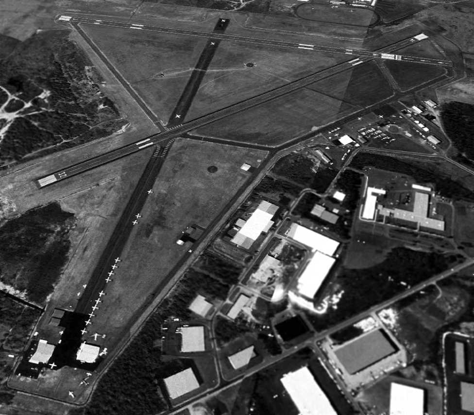
A 5/7/95 aerial view looking southwest at Clinton County Airport showed a well-used facility with numerous based aircraft,
including at least 2 vintage DC-3s among the many aircraft parked at the lower-left at the end of the former Runway 27.

A 6/20/96 photo of N736SL (a 1977 Cessna R172K Hawk XP, C/N: R1722752) & a Grumman Goose amphibian at Clinton County Airport.

A 7/7/06 photo of a 1940s DC-3 departing from Clinton County Airport.

An undated (circa 2000s?) NY DOT directory entry depicted Clinton County Airport
as having 2 paved runways, with the former Runway 9/27 being closed.
During its last year of operation, the FAA Airport/Facility Directory described Clinton County Airport as having a total of 30 based aircraft,
and conducting an average of 39 takeoffs or landings per day.
The manager was listed as Rodney Brown.
Clinton County transitioned to using the nearby Plattsburgh International Airport (the former Plattsburgh AFB) as the primary airport for the region on 6/18/07,
and Clinton County Airport was closed to itinerant aircraft, though it continued to be used for paradrops, and a few aircraft were still based there.
A circa 2007-2011 aerial view looking north at the east end of the former Runway 27,
showing a wingless DC-3 fuselage & the cockpit of a larger aircraft, which appear to be the last aircraft remaining at the former Clinton County Airport.

A circa 2007-2011 aerial view looking north at the hangars on the north side of the former Clinton County Airport.

A 5/27/11 aerial view looking southwest at Clinton County Airport showed only a single aircraft remaining on the entire field:
a vintage DC-3 at the bottom-left.

An 8/18/11 photo of what is evidently the last aircraft to land at the former Clinton County Airport:
a retired Federal Express 727 which was brought into the field to be donated to the Plattsburgh Aeronautical Institute.
An article entitled “Donated FedEx jet lands in Plattsburgh” by Dan Heath in the Press-Republican described the donation:
“A FedEx Boeing 727 made what might be the last landing at the former Clinton County Airport.
A gift to Plattsburgh Aeronautical Institute, the aircraft first made one approach & fly-over, then circled to the right before making a smooth landing.
It taxied to the Aeronautical Institute, where it rolled under a water arch created by 2 water cannons on Morrisonville Fire Department trucks.
Jim McCartney III, principal of the CV-TEC satellite campus that houses the institute there & other programs, said that is the traditional way aircraft are retired from service.
The Boeing 727 is the latest of more than 50 FedEx has given away since it started its Aircraft Donation Program in 1995,
said FedEx Managing Director of Aircraft Acquisitions & Sales David Sutton.
U.S. Representative Bill Owens & Senators Charles Schumer & Kirsten Gillibrand helped support getting the donation this summer,
as it was unknown how long the closed airport might be available for such landings.”
As of 2012, the status of Clinton County Airport was listed as “Closed permanently”.

An 8/25/15 photo by Ron Plante looking North along the former Clinton County Airport Runway 1.
Ron reported, “Except for Plattsburgh Aeronautical Institute (PAI) at the eastern corner, there is zero activity, the runways are unused.
The land is owned by the county, which plans to convert it into an industrial park.”

An 8/25/15 photo by Ron Plante of the last aircraft to land at the former Clinton County Airport:
a retired Federal Express 727 which was brought into the field to be donated to the Plattsburgh Aeronautical Institute.
Ron reported, “Plattsburgh Aeronautical Institute has numerous aircraft outside and inside, largest is the FedEx 727 N279FE.
I also spotted several Hueys, a Fouga CM-170, and a T-39 in Navy markings. ”
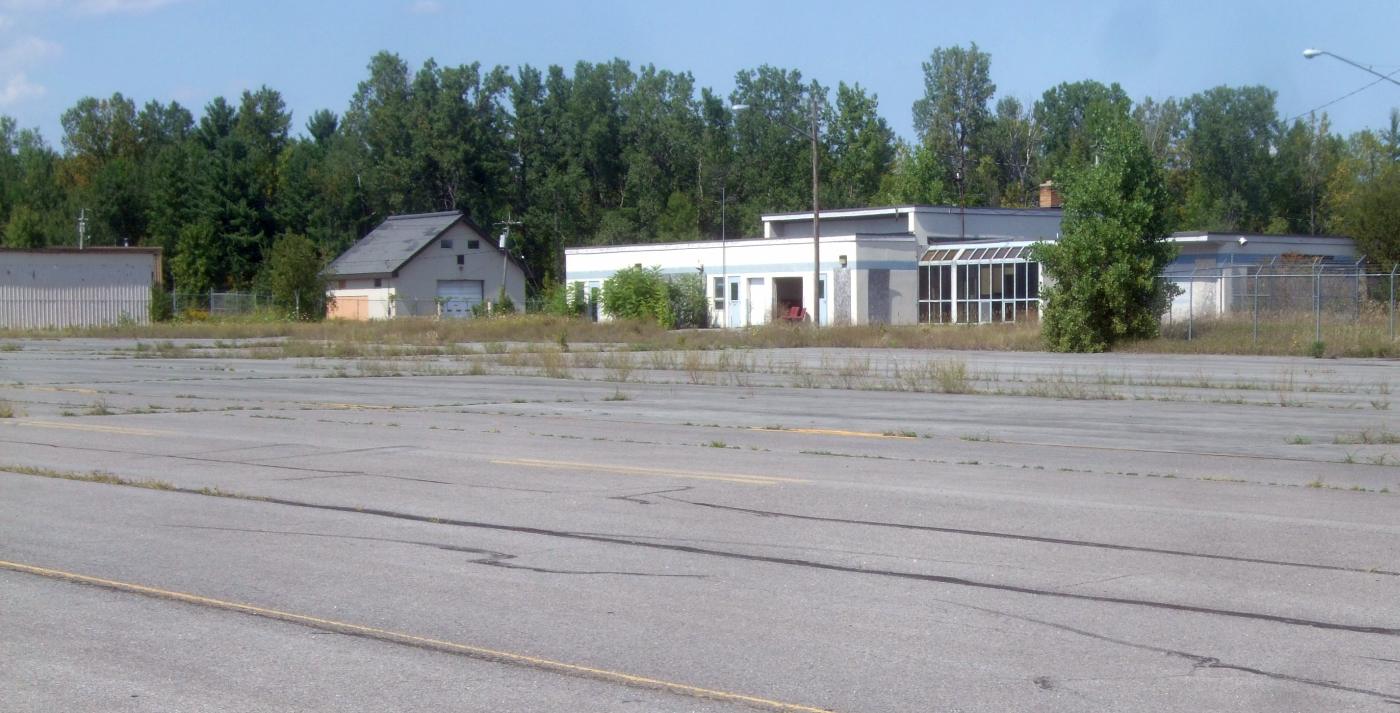
An 8/25/15 photo by Ron Plante of abandoned hangars & the terminal of the former Clinton County Airport.
Ron reported, “The terminal building & hangars are empty.”

An 8/25/15 photo by Ron Plante of the entrance to the abandoned Clinton County Airport terminal.

An 8/25/15 photo by Ron Plante of the PLB VORTAC at the former Clinton County Airport.
Ron reported, “AirNav shows the VORTAC operational as PLB, but there’s no sign or fence.”
The site of Clinton County Airport is located at the southwest terminus of Airport Entrance Road.
____________________________________________________
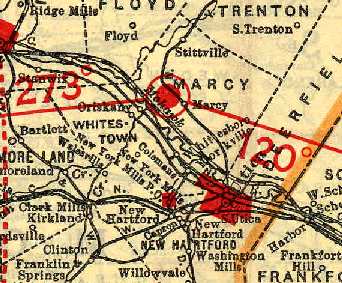
Utica Municipal Airport, Marcy, NY
43.17 North / 75.32 West (East of Syracuse, NY)
Utica Municipal Airport,
as depicted on a 1929 "Rand-McNally Standard Map of NY with Air Trails" (courtesy of Chris Kennedy).
The Utica Municpal Airport was dedicated 6/1/28, according to a historical plaque on the site of the airport.
The earliest depiction which has been located of Utica Memorial Airport
was on a 1929 "Rand-McNally Standard Map of NY with Air Trails" (courtesy of Chris Kennedy).
It described Utica Municipal as having a 3,000' x 3,920' field.
Scott Primiano reported, “My grandfather owned & operated 'Utica Skyways'
with 2 Model 2T-1A Great Lakes Sports Trainers in 1929-30.”
Presumably, this firm operated from the Utica Airport.

The earliest aeronautical chart depiction which has been located of Utica Airport
was on the June 1933 Albany Sectional Chart.

The earliest photo which has been located of Utica Municipal Airport
was a 1935 view of a Waco QCF-2 biplane in front of the main hangar with UTICA painted on the roof.
Gloria Santucci, one of the area's first woman pilots & the first licensed to carry passengers, was a longtime instructor at Utica Airport.

An undated colorized postcard photo depicted a group of biplanes in front of a hangar marked “Utica Municipal Airport”.

An undated aerial view looking west from The Airport Directory Company's 1937 Airports Directory (courtesy of Bob Rambo)
depicted Utica Municipal Airport as having a single hangar, which had "Utica" painted on the roof.
The directory described Utica Municipal Airport as having a total of 4 sod runways,
the longest being a 3,300' northwest/southeast strip.
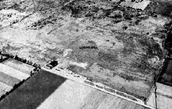
The last photo which has been located of Utica Municipal Airport was a circa 1942-45 aerial view looking north
from the 1945 AAF Airfield Directory (courtesy of Scott Murdock).
It depicted Utica as an open grass area with a hangar on the south side.
The 1945 AAF Airfield Directory (courtesy of Scott Murdock) described Utica Municipal Airport
as a 355 acre irregularly-shaped property having a sod all-way landing area, with the longest dimension being 3,100' northwest/southeast.
The field was said to have 2 hangars, the largest being a 120' square brick structure.
Utica Municipal Airport was described as being owned by the City of Utica & operated by private interests.
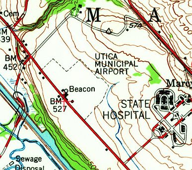
The 1947 USGS topo map depicted Utica Municipal Airport with an outline of the property,
with several buildings (hangars?) & a beacon depicted along the southwest edge of the property.
The June 1953 Hudson River World Aeronautical Chart (courtesy of Chris Kennedy)
depicted Utica as having a 3,100' unpaved runway.
The November 1956 Albany Sectional Chart (courtesy of Chris Kennedy)
described Utica as having a 3,100' "all-way" turf landing area.
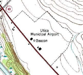
Utica Municipal Airport was still depicted on the 1955 USGS topo map,
with an outline of the property, several buildings (hangars?), and a beacon depicted.
Jim Stanton recalled, “Regarding the original Utica Municipal Airport,
I took my private pilot flight test there in spring of 1958.
I think it was open for a while after that.”
The last aeronautical chart depiction of Utica Airport which has been located
was on the May 1960 Albany Sectional Chart.
It described Utica as having a 3,100' unpaved runway.
Utica Municipal Airport was apparently closed at some point between 1958-62,
as it was no longer depicted on the 1962 Albany Sectional Chart (courtesy of Mike Keefe),
nor listed among active airfields in the 1962 AOPA Airport Directory.
Keith Hunt recalled that the property was used to fly radio-controlled model aircraft in the 1960s.
A historical plaque was erected on the site of Utica Municipal Airport in 1993, on the occasion of the 69th anniversary of the airport's dedication.
A 1997 USGS aerial photo showed that the entire site of Utica Municipal Airport had been obliterated with the construction of a Wal-Mart distribution center,
with not a trace of the former airfield remaining.

A 2015 aerial view looking northeast shows no trace remaining of the Utica Municipal Airport.

A 2015 photo by Andy Frank of a historical plaque on the site of Utica Municipal Airport.

A 2015 closeup by Andy Frank of a historical plaque on the site of Utica Municipal Airport.
The site of Utica Memorial Airport is located east of the intersection of Old River Road & Chaminade Road, across the Erie Canal from Utica.
____________________________________________________
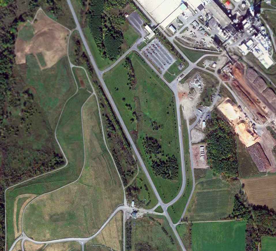
Riverside Airport (4B2), Utica, NY
43.13, -75.27 (East of Syracuse, NY)

Riverside Airport, as depicted on the 1967 Albany Sectional Chart (courtesy of Mike Keefe).
This small general aviation airport was located
only 3 miles southeast of the site of the former Utica Municipal Airport.
Riverside Airport was apparently built between 1965-66,
as it was yet depicted on the July 1965 Albany Sectional Chart.
The earliest reference to Riverside Airport which has been located came from Judy Lust,
who recalled, “Riverside... I took lessons there when I was 18 [1966]. My father flew out of there also.
He had his license for years, but studied with me. His name is Leon Lust. He knew the Ground School teacher, Gloria Santucci.
My Flight Instructor was Al Waskiewicz. Al or somebody else owned a WWII Navy trainer, an SNJ.
It was a nice little airport. The school was accredited, I think, but I'm not sure.
They were aiming for that if it was not yet accredited. I think it was a one year course in aircraft mechanics.
The guys used to get on the radio telephone & say things like, 'Better move out of the way. A 747 is coming in.'
Gloria would get a little riled up & say, 'We'll lose our license if you keep that up!' It was all really fun to listen to!
Riverside was a great airport & I'm sure it's missed. One of the men who hung out there used to be a flight instructor.
Before that, he was a wing walker. His name was Sharkey.”
The earliest aeronautical chart depiction of Riverside Airport which has been located
was on the 1967 Albany Sectional Chart (courtesy of Mike Keefe).
It described Riverside Airport as having a single 2,500' gravel runway.

Riverside Airport's runway was apparently paved at some point between 1967-70,
as the February 1970 Albany Sectional depicted it as having a 2,600' paved northwest/southeast runway.

The only photo which has been located showing Riverside Airport while in operation was a 4/1/74 USGS aerial view.
It depicted a few small aircraft parked near the hangars on the south side of the runway.

A flight simulator scenery depiction looking west at Riverside Airport.
The 1982 AOPA Airport Directory (courtesy of Ed Drury)
described Riverside Airport as having a single 3,500' asphalt Runway 14/32.
Strangely, Riverside Airport was not depicted at all on the 1985 USGS topo map.
Mark Hrutkay observed of Riverside, “It was a nice place;
it had a aviation mechanics school & lots of stories.
It was wedged between the Thruway & the Erie Barge Canal, so the seaplanes could take off.
Gordon Newell (who owned the airport) had a super nice Widgeon he kept there.”

In the 1995 Jeppesen Airport Directory, the operators at Riverside Airport were listed as
Landcare Aviation, Inc. & Mark's Flight Training.
According to Mark Hrutkay, Riverside “got sold to NY Thruway commission since it was right next to the Thruway.”
Jonathan Westerling reported, "While closed, the Riverside airport is very much intact.
I visited it back in 1997. It is right next to the canal, visible from the Throughway & easily accessible.
The land is private, and there were no trespassing signs."

Riverside was evidently closed (for reasons unknown) at some point between 1995-99.
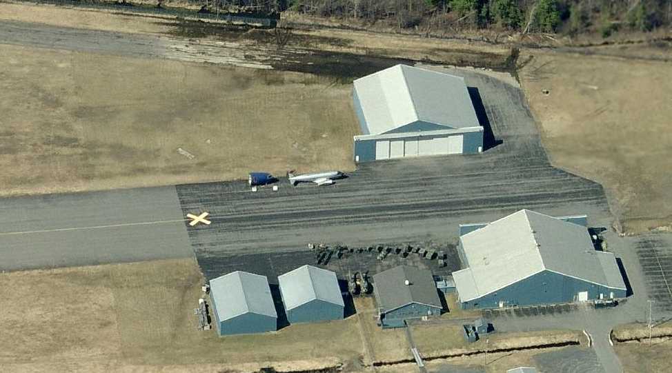
Although it was closed at the date of the 1999 USGS photo (note the closed runway "X" markings),
there were still 3 light aircraft visible parked on the ramp.
Riverside was still depicted as an abandoned airfield on 2002 aeronautical charts.
However, Ed Hamlin reported that a 2003 aerial photo showed that “As far as Riverside is concerned,
the airport no longer exists - the runways were removed in order to construct major highway interchanges in the area.
There is nothing there next to the marina anymore. There is no sign that there ever was an airport there.”

A circa 2000-2005 USGS aerial photo showed a dramatic difference compared to the 1999 USGS aerial photo.
All of the buildings on the field had been removed, along with some of the pavement from the runway.
However, the remains of the length of the paved runway was still quite evident.
Riverside Airport is located south of Interstate 90 & north of the Erie Canal, northwest of Route 8.
____________________________________________________
Since this site was first put on the web in 1999, its popularity has grown tremendously.
That has caused it to often exceed bandwidth limitations
set by the company which I pay to host it on the web.
If the total quantity of material on this site is to continue to grow,
it will require ever-increasing funding to pay its expenses.
Therefore, I request financial contributions from site visitors,
to help defray the increasing costs of the site
and ensure that it continues to be available & to grow.
What would you pay for a good aviation magazine, or a good aviation book?
Please consider a donation of an equivalent amount, at the least.
This site is not supported by commercial advertising –
it is purely supported by donations.
If you enjoy the site, and would like to make a financial contribution,
you
may use a credit card via
![]() ,
using one of 2 methods:
,
using one of 2 methods:
To make a one-time donation of an amount of your choice:
Or you can sign up for a $10 monthly subscription to help support the site on an ongoing basis:
Or if you prefer to contact me directly concerning a contribution (for a mailing address to send a check),
please contact me at: paulandterryfreeman@gmail.com
If you enjoy this web site, please support it with a financial contribution.
please contact me at: paulandterryfreeman@gmail.com
If you enjoy this web site, please support it with a financial contribution.
____________________________________________________
This site covers airfields in all 50 states.