Abandoned & Little-Known Airfields:
Southeastern New York State
© 2002, © 2016 by Paul Freeman. Revised 10/6/16.
This site covers airfields in all 50 states: Click here for the site's main menu.
____________________________________________________
Please consider a financial contribution to support the continued growth & operation of this site.
Black Pond Airfield (revised 1/20/12) - Grossinger's Airport / Liberty Airport (revised 1/3/15) - Huguenot Airport (revised 5/26/13) - Livingston Manor Airport (revised 1/3/15)
Mahopac Airport (revised 4/29/14) - Poughkeepsie Airport / Red Oaks Mill Airport (revised 11/23/14) - Sages Airport (revised 11/9/15)
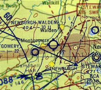
Sha-Wan-Ga Valley Airport (added 8/1/16) - Stormville Airport (revised 1/3/15) - Tri-State Airport / Montgomery Airport (revised 7/4/16) - Walden Airport (revised 2/2/16)
Wallkill Aux AAF #2 / Galeville Airport / Wallkill Airport / Ulster County Airport / Galeville AAF (revised 10/6/16)
____________________________________________________
Sha-Wan-Ga Valley Airport (8NY7), Bloomingburg, NY
41.571, -74.402 (Northwest of New York, NY)
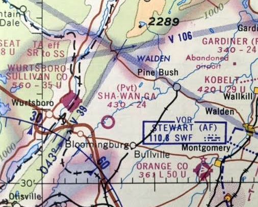
Sha-Wan-Ga Valley Airport, as depicted on the October 1968 NY Sectional Chart (courtesy of Gabriel Hernandez).
This small general aviation airport was evidently established in 1968,
as it was not yet depicted on the March 1968 NY Sectional Chart (courtesy of Gabriel Hernandez).
The earliest depiction which has been located of Sha-Wan-Ga Valley Airport
was on the October 1968 NY Sectional Chart (courtesy of Gabriel Hernandez).
It depicted Sha-Wan-Ga as a private airfield having a 2,400' unpaved runway.
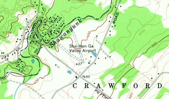
The 1969 USGS topo map depicted Sha-Wan-Ga Valley Airport as having 2 unpaved runways, with a few small buildings on the southeast side.
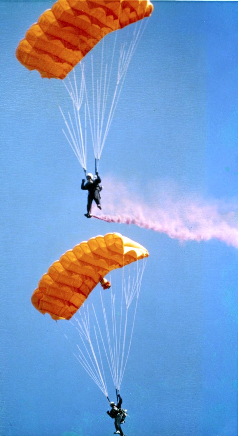
Sha-Wan-Ga Valley Airport evidently conducted parachuting operations,
as Robert Hobbs reported, “I made 2 jumps here from 10/3/70-3/6/71.”
Sha-Wan-Ga Valley Airport was evidently closed at some point between 1971-72,
as it was no longer depicted on the June 1972 NY Sectional Chart (courtesy of Gabriel Hernandez).
Sha-Wan-Ga Valley Airport was evidently reopened as a public-use airport at some point between 1972-77,
as it was depicted as such on the June 1977 NY Sectional Chart (courtesy of Gabriel Hernandez),
with a 2,300' unpaved runway.
The June 1980 NY Sectional Chart (courtesy of Gabriel Hernandez)
continued to depict Sha-Wan-Ga Valley Airport with a 2,300' unpaved runway.
Sha-Wan-Ga Valley Airport's depicted runway length decreased to a mere 1,800'
on the December 1982 NY Sectional Chart (courtesy of Gabriel Hernandez).

The last aeronautical chart depiction which has been located of Sha-Wan-Ga Valley Airport
was on the December 1984 NY Sectional Chart (courtesy of Gabriel Hernandez).

The earliest photo which has been located of Sha-Wan-Ga Valley Airport was a 1994 USGS aerial view looking northeast.
It depicted Sha-Wan-Ga Valley as having one asphalt runway & a grass crosswind runway.
Four light single-engine aircraft were parked near the 2 hangars at the southeast side.

The last photo which has been located showing aircraft at Sha-Wan-Ga Valley Airport was a 2007 aerial view looking northeast.
Three light single-engine aircraft were parked near the 2 hangars at the southeast side.

A 4/9/09 photo of the Sha-Wan-Ga Valley Airport hangars.

A 2016 aerial view looking northeast showed Sha-Wan-Ga Valley Airport to remain intact, though without any aircraft visible.
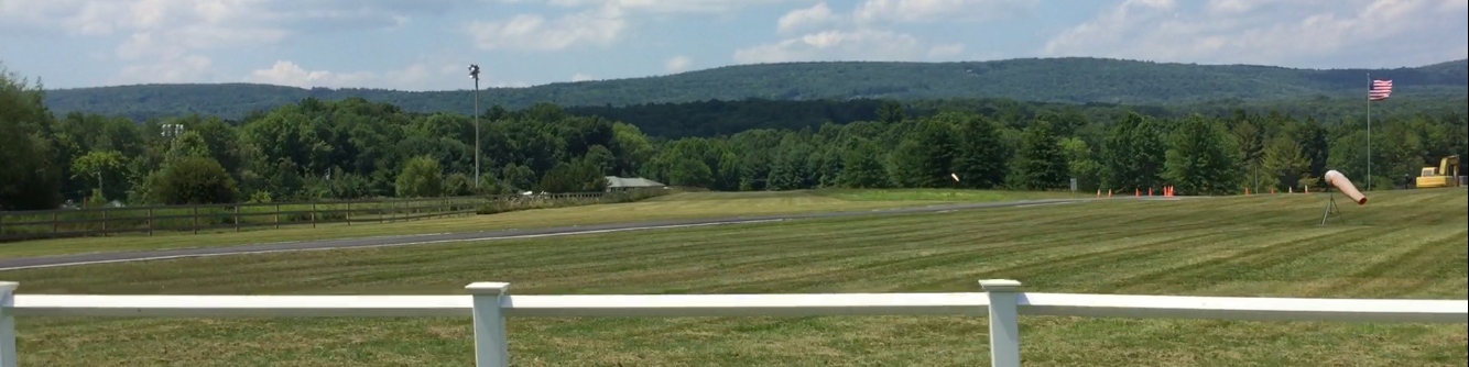
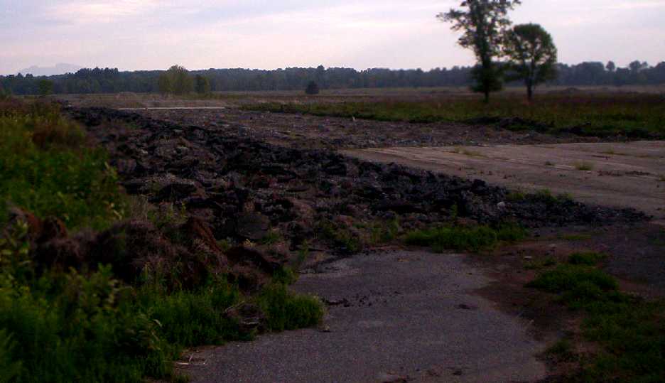
A 7/24/16 photo by Gabriel Hernandez of the Sha-Wan-Ga Valley Airport paved runway.
Gabriel reported, “The runway still exists, but the surrounding property has been split into lots for sale.”
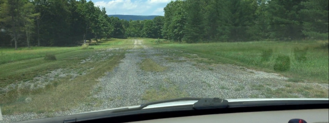
A 7/24/16 photo by Gabriel Hernandez looking along Sha-Wan-Ga Valley Airport's former Runway 33.
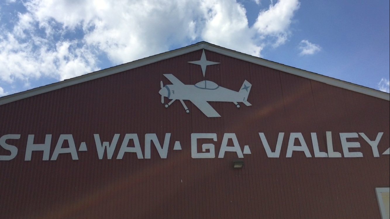
A 7/24/16 photo by Gabriel Hernandez of the sign on the Sha-Wan-Ga Valley Airport hangar.
Gabriel reported, “Some buildings still exist, but have been transformed for other use.”
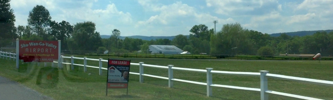
A 7/24/16 photo by Gabriel Hernandez of the sign in front of Sha-Wan-Ga Valley Airport.
As of 2016, Sha-Wan-Ga Valley Airport was no longer listed with the FAA.
Sha-Wan-Ga Valley Airport is located north of the intersection of Petticoat Lane & Stone Schoolhouse Road.
Thanks to Gabriel Hernandez for pointing out this airfield.
____________________________________________________
Tri-State Airport / Montgomery Airport, Montgomery, NY
41.516, -74.252 (North of New York, NY)
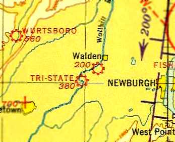
Tri-State Airport, as depicted on the 1935 10M Regional Aeronautical Chart (courtesy of Chris Kennedy).
The date of establishment of Tri-State Airport has not been determined.
The earliest depiction which has been located of Tri-State Airport
was on the 1935 10M Regional Aeronautical Chart (courtesy of Chris Kennedy).
It depicted Tri-State as a commercial/municipal field.
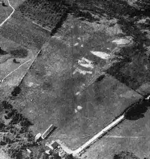
The earliest photo which has been located of Tri-State Airport was an 8/7/42 aerial view looking north from the 1945 AAF Airfield Directory (courtesy of Scott Murdock).
It depicted “Tri-States Airport” as an open grass area with a few small buildings on the southwest side.

Tri-State Airport, as depicted on the 1943 USGS topo map.
The 1945 AAF Airfield Directory (courtesy of Scott Murdock) described “Tri-States Airport”
as a 120 acre irregularly-shaped property having a sod all-way landing area, with the longest dimension being 2,200' north/south.
The field was said to have 3 hangars, the largest being a 180' x 30' wood & metal structure.
Tri-States Airport was described as being owned & operated by private interests.
According to Jeff Gorss, “Tri-State Airport pre-dates the present-day Orange County Airport & was located almost immediately north-east of where that facility was constructed.
My father & my uncle were the operators of the grass-strip Tri-State Airport in the late 1940s.
My father was a B-17 & B-24 pilot at the end of WW II, and my uncle had been a civilian instructor for the Civilian Pilot Training Program.
Together they opened Gorss Flying Service at the Tri-State Airport – they ran what we now generally refer to as an Fixed-Base Operation.
They flew power line patrols; offered flying lessons, fuel, hangars & tie-down rentals; and provided aircraft inspection & repair services.
I’ve been told that planes on straight floats occasionally landed on a nearby stretch of the Wallkill River for inspections (and possibly for certain types of repairs).
Along with T-hangars & a small office/classroom building, there was a fairly large maintenance hangar that could accommodate several planes at a time.”
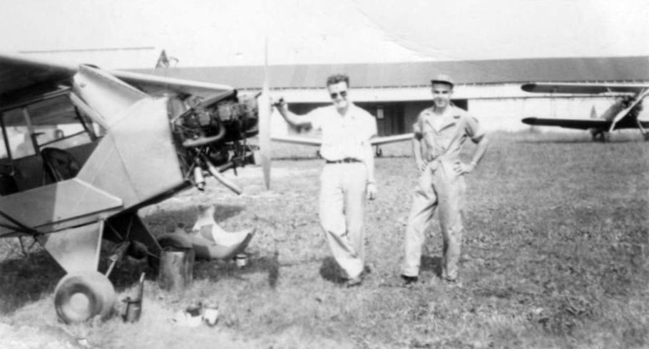
An undated photo of Jerry & Don Gorss with a Piper Cub undergoing maintenance at Tri-State Airport (courtesy of Chris Jacks, via Jeff Gorss).
An undated photo of Jerry & Lynne Gorss in front of the Airport Inn at Tri-State Airport (courtesy of Chris Jacks, via Jeff Gorss).

An undated photo of Lynne Gorss in front of a hangar at Tri-State Airport (courtesy of Chris Jacks, via Jeff Gorss).
According to Jeff Gorss, “Sometime after 10/31/48 (the last entry in my father’s logbook),
a fire started by some welding work resulted in the maintenance hangar burning to the ground, along with several planes inside it.
After the hangar fire at Tri-State, the Gorss brothers tried to work with the county to develop KMGJ [the present-day Orange County Airport]
into an active general aviation facility, but their efforts were for naught.
Without the maintenance hangar & the business income it provided, Tri-State was no longer a viable operation,
the Gorss brothers moved on to other endeavors, and Tri-State eventually degraded to cornfields & abandoned vehicles.”

The 1956 USGS topo map depicted Tri-State Airport as having a single northwest/southeast unpaved runway,
with a few small buildings on the southwest side.
It also depicted how close the “Montgomery Airport” was located, less than a quarter-mile to the southwest.

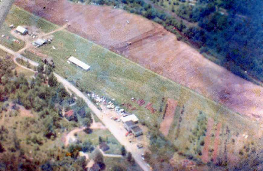
A 7/21/58 USGS aerial view depicted Tri-State Airport as having 2 grass runways.
What appear to be 4 light aircraft were visible parked near the buildings on the southwest side.

At some point between 1956-59, the airport was evidently renamed “Montgomery”,
as the former Mongomery Airport to the southwest was renamed Orange County,
as depicted on the 1959 USGS topo map.

The last aeronautical chart depiction which has been located of the Montgomery Airport was on the 1965 NY Sectional Chart.
Montgomery Airport's depicted runway length had shrunken to only 1,800'.
Montgomery Airport was evidently closed at some point between 1965-67,
as it was no longer depicted on the 1967 NY Sectional Chart.

A 4/27/74 USGS aerial view showed that the Tri-State Airport site was still mostly intact,
though a portion of the northwest/southeast runway had been plowed over at some point between 1958-74.

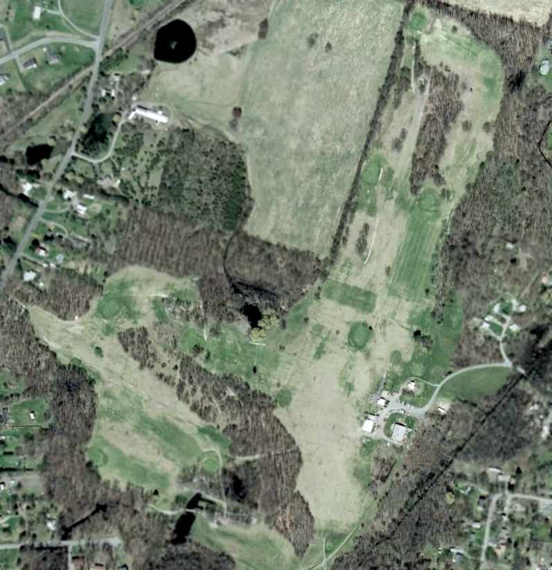
A 2013 aerial view showed the majority of the site of Tri-State Airport remained clear.
The small building at the southwest corner possibly remained from the site's airport days.

A 7/3/16 aerial view by Paul Freeman looking southeast at the site of Tri-State Airport.
The site of Tri-State Airport is located north of the intersection of Union Street & Route 416.
Thanks to Jeff Gorss for pointing out this airfield.
____________________________________________________
41.779, -74.27 (North of New York, NY)

Sages Airport, as depicted on the 1965 NY Sectional Chart.
Photo of the airport while in use has not been located.
This small general aviation airport may have been established at some point between 1961-65,
as it was not yet depicted on the 1961 USGS topo map.
The earliest depiction which has been located of Sages Airport was on the 1965 NY Sectional Chart,
which depicted Sages as a private airfield with a 2,500' runway.

The 1969 USGS topo map depicted Sages Airfield as having an unpaved northeast/southwest runway,
with 5 small buildings on the south side.
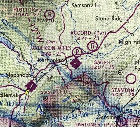
The last aeronautical chart depiction which has been located of Sages Airport was on the 1975 NY Sectional Chart,
which depicted Sages as a public-use airport with a 2,500' paved runway,
both of which were changes from previous depictions.
Bill Hopkins recalled, “I started flying in the late 1970s.
Most of my training was done at Sages Airport in Kerhonkson. The owner was Sam Cohen.
Sages runways were 8/26 with the Granite hotel as a marker for turning base on [Runway] 26.
I remember there to be a constant crosswind on those runways. I used to joke that I learned to land on one wheel before two.
My first solo, we trained in Sam's Cessna 150; I leveled my wings too soon from a slip & drifted a bit off the pavement into some muddy grass.
After a few more (much better) landings Sam called me in & walked up to me with a bucket & brush to clean off the mud from the undercarriage
while joking to his other instructor 'See, I told you he'd only miss the runway once!'”

The Sages runway was still depicted on the 1987 USGS topo map,
but it was labeled simply as “Landing Strip”, which may indicate that the airport had been closed by that point.

A circa 2011 aerial view looking south showed the paved Sages Airport runway in a deteriorated state,
with a trailer having been situated directly adjacent to the south side of the runway, presumably after the airport's closure.
A building (possible hangar?) sat to the southwest side of the runway, with a partially collapsed roof.

A 2013 aerial view looking southeast showed the paved Sages Airport runway in a deteriorated state,
but the airport property otherwise remained intact.
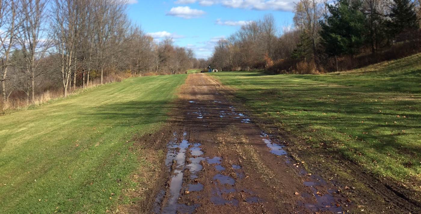
An 11/8/15 photo by Gabriel Hernandez of the Sages Airport runway.
Gabriel reported, “The runaway is mowed weekly by a 90 year old man named Carlos.
He lives with his wife in a trailer on the south side of the runway. He said no one has landed there in 10 years.”
The site of Sages Airport is located at the northern terminus of Green Haven Lane.
Thanks to Bill Hopkins for pointing out this airfield.
____________________________________________________
Poughkeepsie Airport / Red Oaks Mill Airport, Red Oaks Mill, NY
41.65, -73.88 (North of New York, NY)
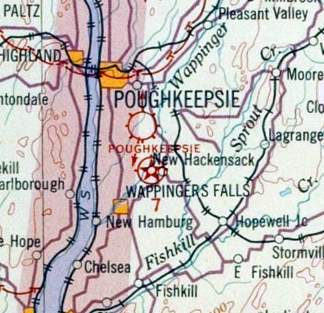
Poughkeepsie Airport, as depicted on the November 1931 NYC-Albany Air Navigation Map.
According to an article by Anthony Musso in the Poughkeepsie Journal, the Poughkeepsie Airport at Spackenkill & Vassar roads
was established in 1927 amid nationwide excitement that was generated from that year's New York-to-Paris nonstop solo flight by Charles Lindbergh.
“Located on property owned by Fred Cleveland, Poughkeepsie Mayor John Kelsey Sague had the city lease the land and start the airport in 1927",
said Town of Poughkeepsie Historian Jean Murphy.
"Sague's son-in-law, John Miller, a barnstorming pilot, ran the Red Oaks Mill Airport from 1931-33", Murphy explained.
Poughkeepsie Airport featured 2 dirt runways and an 80x100' hangar.
Prohibition provided work at the local airport.
"Most of the lucrative business at the Red Oaks Mill Airport was the repair of bootleggers' planes,
which experienced much wear in frequent trips across the Canadian border", said Poughkeepsie's Albert Gerney.
The earliest depiction which has been located of Poughkeepsie Airport was on the November 1931 NYC-Albany Air Navigation Map.
Because the Red Oaks Mill Airport was too small to handle the increasing size of airplanes,
the U.S. Commerce Department opened another airport in 1932 just south in New Hackensack
to serve as an emergency landing field halfway between New York City & Albany.
John Miller gave up oversight of the airport at the end of Prohibition [1933].
The reason? A significant falloff in income generated from repairs made there.
During Red Oaks Mill Airport's heyday, Cole Palen, a student at a 1-room schoolhouse across from the hangar
(in a building now occupied by the Fitzgerald Tile Company) was inspired to get involved in aviation.
Palen took his first flight from the airport in 1935 at 10 years old.
According to local pilot Charles Conklin, “There were weekly airshows & I remember one in particular,
the Ford [Tri-Motor], an American Airline Curtis Condor, a Fokker D-8, a Spad & several other biplanes.
Also there was a German pilot who was an ace from WW1.
Every one of these airplanes was STOL [Short TakeOff & Landing] like maybe 300-400'.
I rode in the EAA Ford, in the right hand seat, and actually flew it for 10-15 minutes. A Sherman tank with wings.
I would guess [it was the] early to mid-1930s.”

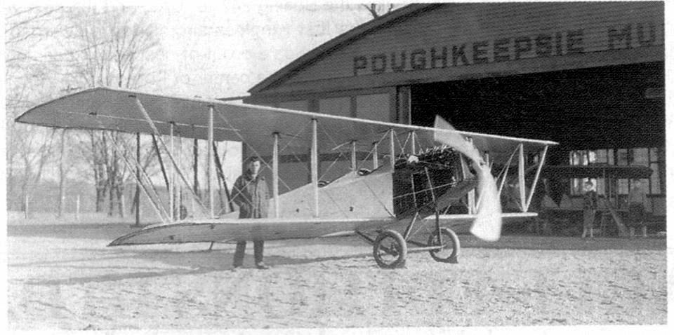
The earliest photo which has been located of Poughkeepsie Airport was a 5/1/36 aerial view.
It depicted a rectangular grass airfield with a single hangar at the northeast corner.

A closeup from the 5/1/36 aerial view looking northwest at the hangar marked “Poughkeepsie Airport”.

Poughkeepsie Landing Field, as depicted on the 1936 USGS topo map.

A circa 1930s photo of an unidentified group in front of Captain Johnny Miller's New Standard D25 biplane, and a hangar marked “Poughkeepsie”.

A circa 1930s photo of New Standard NC193E at Poughkeepsie Airport.
According to Gary Hyatt, “That’s John Miller’s airplane, it appears twice on my websites (www.dmairfield.org & www.parksfield.org) flown by Homer Fackler.
It was the 'chase' plane that followed Miller across the US in 1931 when he set his cross-country autogyro record.”
A circa 1930s photo of John Miller & a Curtiss JN-4 Jenny biplane in front of a hangar marked “Poughkeepsie”.
According to Gary Hyatt, “This was Miller’s first airplane; rebuilt by him.”
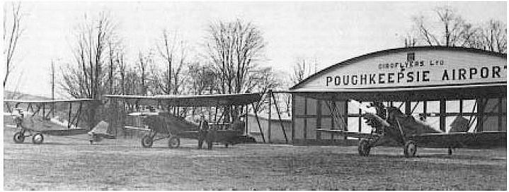
A circa 1930s photo of 3 biplanes in front of a hangar marked “Giroflyers Ltd. Poughkeepsie Airport”.


"The noise at the Red Oaks Mill Airport became burdensome to neighbors, especially Mr. Howell,
who lived next door to today's Mobil gas station at the busy intersection," Gerney said.
"Howell bought the property from Cleveland, shut the airport down in 1938 & sold off parcels to build houses," Albert Gerney added.
The Poughkeepsie Airport was no longer depicted on the 1943 USGS topo map.
The Red Oaks Mill Airport hangar was subsequently used as a post office & blacksmith shop.
In the late 1960s, Hilber Heuer's Hardware Store operated in the structure.
A fire destroyed the structure, thereby eliminating the last remnant of aviation history in the community.
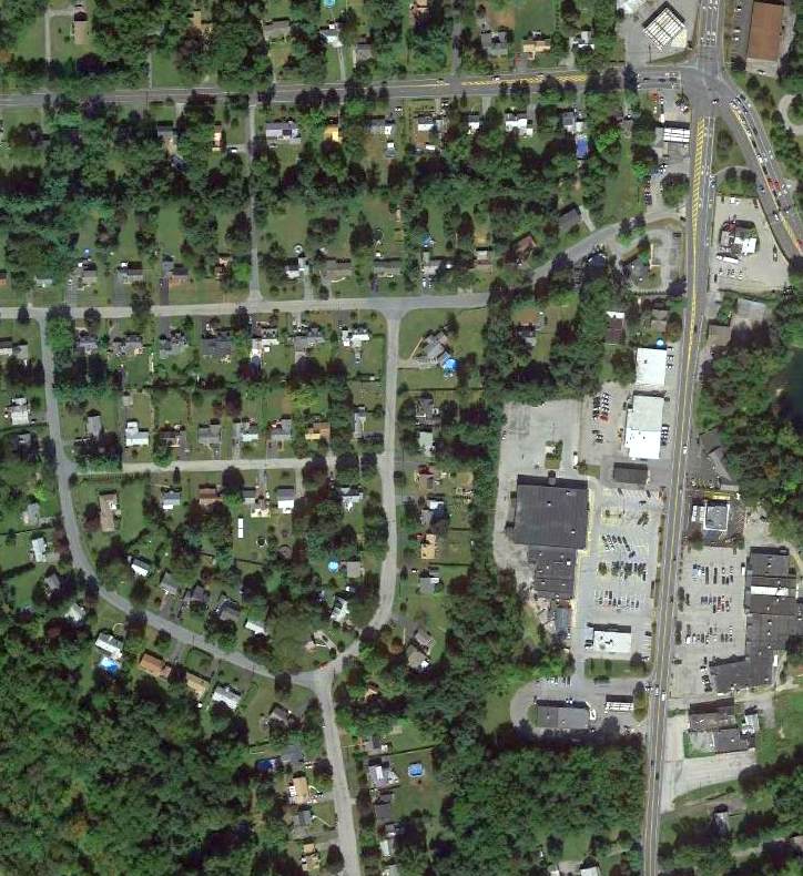
A 2013 aerial view showed no trace remaining of Poughkeepsie Airport.
The site of Red Oaks Mill Airport is located southwest of the intersection of Spackenhill Road & Vassar Road.
Thanks to Ian Barren for pointing out this airfield.
____________________________________________________
Huguenot Airport, Huguenot, NY
41.406, -74.644 (Northwest of New York, NY)
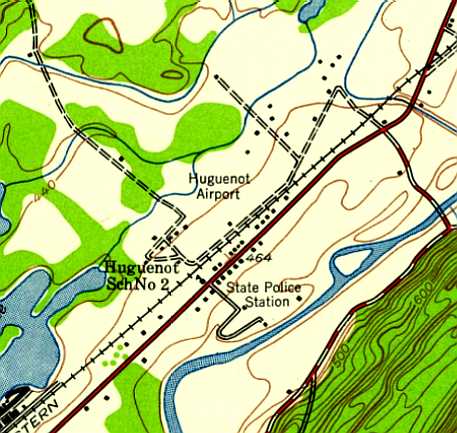
Huguenot Airport, as depicted on the 1942 USGS topo map.
According to Rich MacVicar, Huguenot Airport “opened about 1931 or 32. A friend soloed there in 1932.”
According to the Town of Deerpark Historian Norma Schadt, “The Civil Air Patrol was active in the airport during World War II.”
Jack Taipale recalled, “Harry Gordon, the summer [of 1943] started an operation at Huguenot Airport,
where I soloed in August of 1943.”
According to Rich MacVicar, “A guy named Felix Muchoe said he ran it in 1944 or sooner.”

The earliest aeronautical chart depiction which has been located of Huguenot Airport
was on the 1945 NY Sectional Chart, which depicted Huguenot as a commercial/municipal airport.
According to the Town of Deerpark Historian Norma Schadt, Huguenot Airport was listed in the 1948 T. B. Haire Airport Directory,
and there was a reference to the airport in the 7/25/49 Middletown Times Herald.
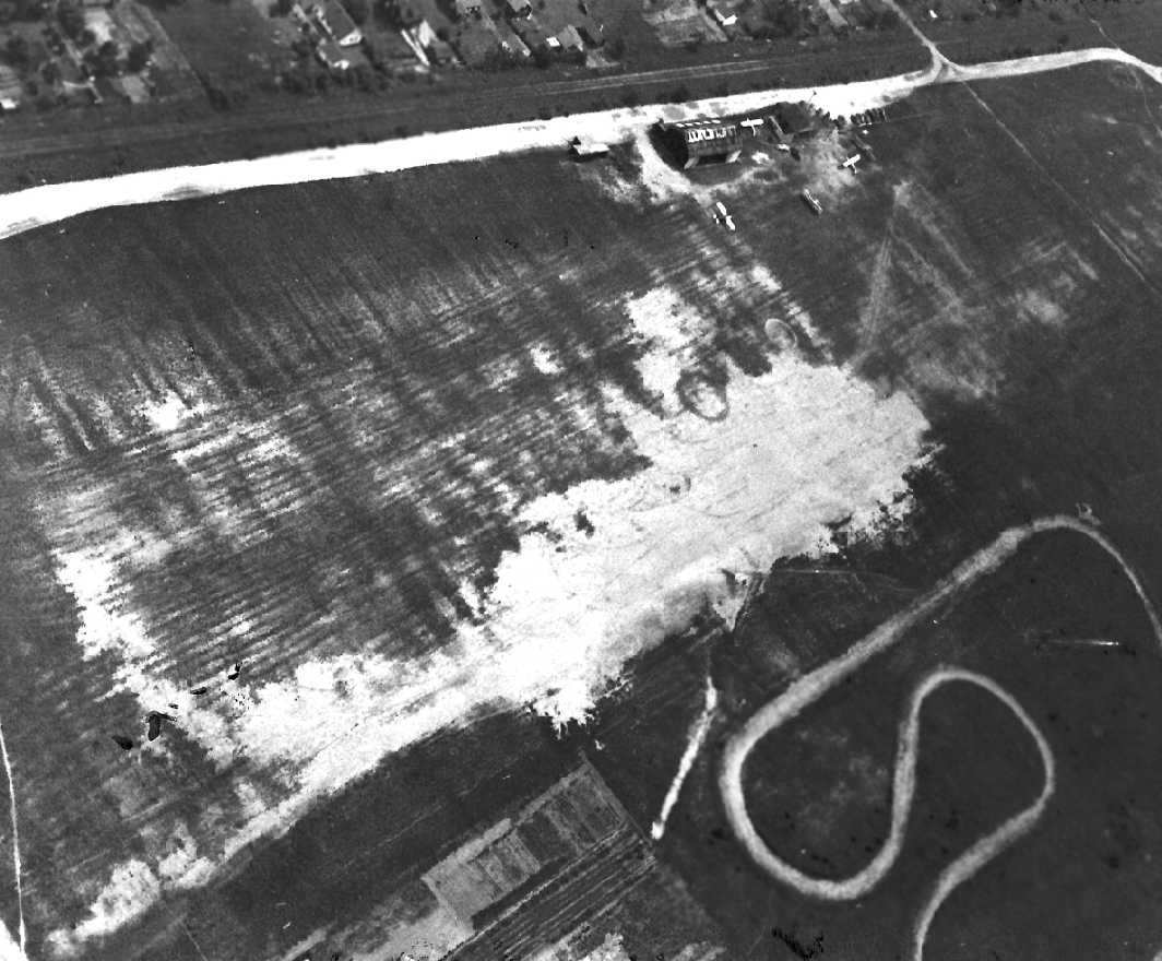
An undated aerial view looking south at Huguenot Airport (courtesy of Norma Schadt)
showed 4 single-engine planes parked around 3 small hangars on the southeast side of a grass airfield.

An undated photo of Betty Ehre hand-propping a Cessna T-50 at Huguenot Airport (courtesy of Norma Schadt).
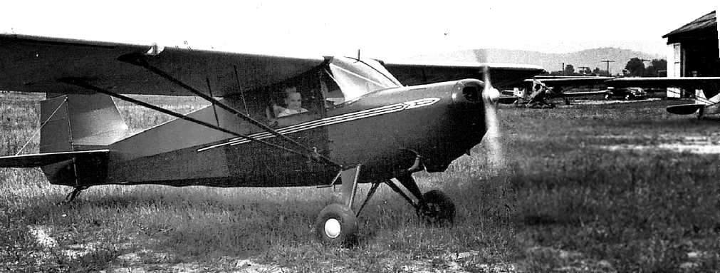
An undated photo of a Skyranger at Huguenot Airport (courtesy of Norma Schadt),
also showing several other planes in front of a hangar.
According to Rich MacVicar, “The Skyranger was one of the Skyrangers stored there when the factory in Long Island folded.
All of the unsold aircraft were stored at Huguenot airport.”

An undated photo of George McGinnis in front of a Civil Air Patrol Aeronca at Huguenot Airport (courtesy of Norma Schadt).
The photo is 1948 or later, judging from the Aeronca's USAF insignia.

The last aeronautical chart depiction which has been located of Huguenot Airport
was on the July 1950 NY Sectional Chart (courtesy of Jim Stanton).
It depicted Huguenot as having a 2,000' unpaved runway.
According to Rich MacVicar, the Huguenot Airport “was busy until about 1951 or 1952.”
Huguenot Airport was evidently closed (for reasons unknown) by 1952
as it was no longer depicted on the 1952 NY Sectional Chart or subsequent aeronautical charts.
According to Rich MacVicar, “In 1954 or 1955 the Rockland County Civil Air Patrol took it over for a short time
and we ran out of there during the big flood in 1956.”
According to the Town of Deerpark Historian Norma Schadt
there was a reference to Huguenot Airport in the 11/10/58 Middletown Times Herald.
According to Norma Schadt, “The Huguenot Airport stopped service in the 1960s.”

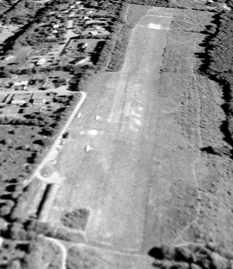
The last photo which has been located showing Huguenot Airport still intact was a 4/8/63 aerial view.
It depicted the field to have a single unpaved northeast/southwest runway, with 2 small hangars on the southeast side.
Although the field remained intact, there was no sign of recent aviation usage.
According to Rich MacVicar, “It was still open when I came to Middletown in 1964.”
A 1968 aerial photo showed some houses had been built on either end of the Huguenot runway,
but the majority of the runway remained intact, along with 2 hangars.
According to Rich MacVicar, “A guy was doing some commercial work [at Huguenot] with a Cessna 175 up until about 1968 or 1969.
Then it was sold & closed & became a trailer park.”
A 1975 aerial photo showed more houses had been built on the northeast end of the Huguenot runway,
but the 2 hangars remained standing.
A 1998 USGS aerial photo showed the hangars had been removed at some point between 1975-98.
Houses covered the site, with no remaining trace of Huguenot Airport.

A 9/12/12 aerial view showed no trace remaining of Huguenot Airport.
Town of Deerpark Historian Norma Schadt reported in 2013, “Today the land is a mobile home park called 'Airport Park'.”
The site of Huguenot Airport is located at the intersection of Airport Road & Hangar Road, appropriately enough.
____________________________________________________
Mahopac Airport (N77), Mahopac, NY
41.382, -73.766 (North of New York, NY)

Mahopac Airport, as depicted on the July 1950 NY Sectional Chart (courtesy of Jim Stanton).
This little general aviation airport was evidently established at some point between 1945-50,
as it was not yet depicted on the 1945 NY Sectional Chart.
The earliest depiction which has been located of Mahopac Airport was on the July 1950 NY Sectional Chart (courtesy of Jim Stanton).
It depicted Mahopac as having a 2,000' unpaved runway.

The 1956 USGS topo map depicted Mahopac Airport as a north/south outline, labeled simply as “Airfield”,
with 2 small buildings in the northeast corner.
The 1965 NY Sectional Chart depicted Mahopac as having an 1,800' unpaved runway.
Tom Kinstler recalled, “I learned to fly at the Mahopac Airport in 1966.
Art Neeves was my flight instructor.
I have many pleasant memories of learning & flying there in mid-1960s.
The old airport was a very friendly place - Saturday night clambakes, etc.
The [building] at the northeast corner of the airport was a Fixed-Base Operator,
and there was a wooden hangar just north of the FBO.
There was a cast of characters at the airport, one was Walter Grossman who was a pilot for the Germans in WW1.
He flew a Halberstadt during the WW1 & had many tales to tell - I suspect that most of them were true.
He was a great old guy, as were most of the airport crowd.”

The last aeronautical chart depiction which is available of Mahopac Airport was on the 1975 NY Sectional Chart.
It depicted Mahopac as having an 1,800' unpaved runway.
The earliest photo which has been located of Mahopac Airport was a 1974 aerial view.
It depicted a total of 14 single-engine aircraft parked on the northeast side of the field.
A 6/23/93 aerial view looking south showed 3 single-engine aircraft on the northeast side of Mahopac Airport.
A 4/19/94 aerial view did not show any aircraft on the field.

The last photos which have been located showing Mahopac Airport in operation
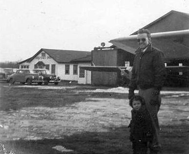
was a set of 3 June/July 1998 photos (courtesy of Ian Baren) of a Falcon XP ultralight at Mahopac Airport.
Ian Baren reported, “That's me in the back, and the instructor in front.
I only flew at N77 10 times, all lessons in the XP.”
Mahopac Airport was reportedly “closed since circa 2000-2001 to make way for a golf course or condos.”
However Ian Baren reported that Mahopac Airport was still depicted on the November 2002 Sectional Chart as a private airfield.
A 4/23/02 aerial view showed the hangar to remain intact, but there were no aircraft visible.
A 3/31/04 aerial view showed that the hangar had been removed at some point between 2002-2004.
A 9/30/06 aerial view showed that soccer fields had been laid out along the runway.

A 10/7/11 aerial view looking south shows that the Mahopac runway area remains clear.

A March 2014 photo by Steve St. Saviour looking south along the Mahopac runway.
Mahopac Airport is located southwest of the intersection of Hill Street & Airport Road, appropriately enough.
Thanks to Tom Kinstler for pointing out this airfield.
____________________________________________________
Grossinger's Airport / Liberty Airport, Liberty, NY
41.8, -74.702 (North of New York, NY)
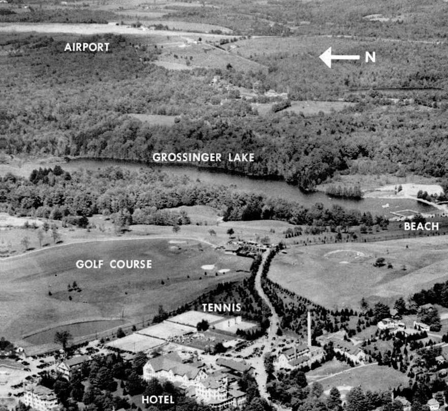
An undated aerial view looking east at the Grossinger Airport from an April 1947 article (courtesy of Anthony Mayo).
Grossinger's Catskill Resort Hotel was a resort in the Catskill Mountains, known as one of the resorts of the “Borscht Belt”.
It was established by Asher Grossinger in 1919 on a 100-acre property.
No airfield was yet depicted at this location on the 1945 NY Sectional Chart.
At some point between 1945-47 the Grossinger's Resort gained its own airport.
The earliest depiction which has been located of Grossinger's Airport
was an undated aerial view looking east at the Grossinger Airport from an April 1947 article (courtesy of Anthony Mayo).
The article described Grossinger Airport as having a 2,800' north/south runway,
planned to “be extended in the immediate future to 4,000'”,
with “another 1,800' rock & stone runway” running east/west.
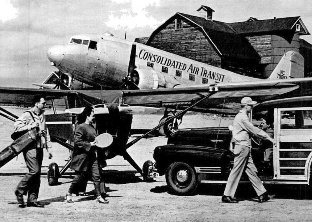
An undated photo of A Consolidated Air Transit DC-3 at the Grossinger Airport from an April 1947 article (courtesy of Anthony Mayo).
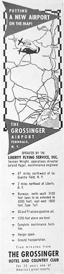
A 1947 advertisement for the Grossinger Airport.

The earliest aeronautical chart depiction which has been located of Grossinger's Airport
was on the July 1950 NY Sectional Chart (courtesy of Jim Stanton).
It depicted “Grossingers” as having a 3,000' unpaved runway.
During the 1950s, professional boxer Rocky Marciano reportedly trained within the Grossinger Airport hangar.

Grossinger Airport, as depicted on a 1955 NY State Airport Directory.
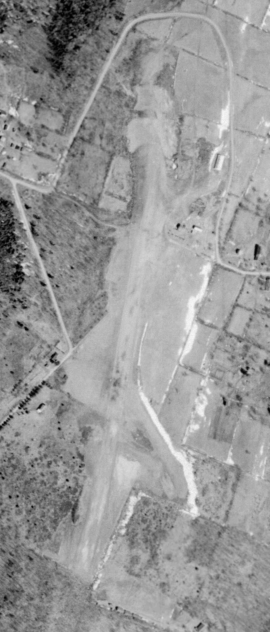
A 4/6/63 USGS aerial view depicted Grossinger as having a single northeast/southwest grass runway, with a single hangar on the east side.
There were no aircraft visible on the field.

The airport was evidently renamed “Liberty” Airport at some point between 1955-65,
as that is how it was labeled on the 1965 NY Sectional Chart.
Liberty was depicted as having a 2,800' unpaved runway.
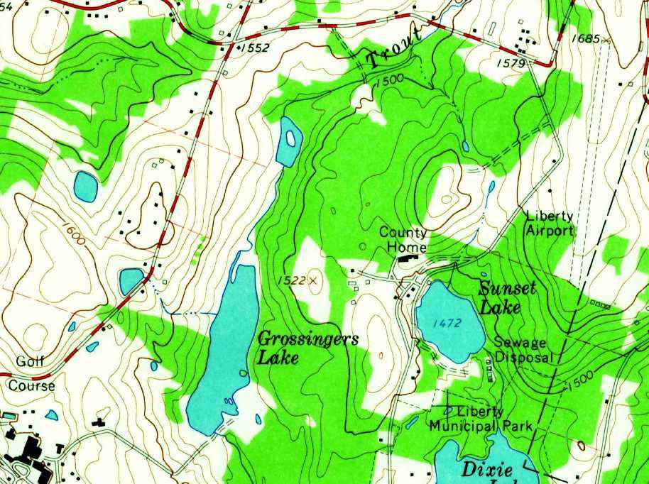
The 1966 USGS topo map depicted Liberty Airport as having a single unpaved northeast/southwest runway
with 3 small buildings on the west & northeast sides.
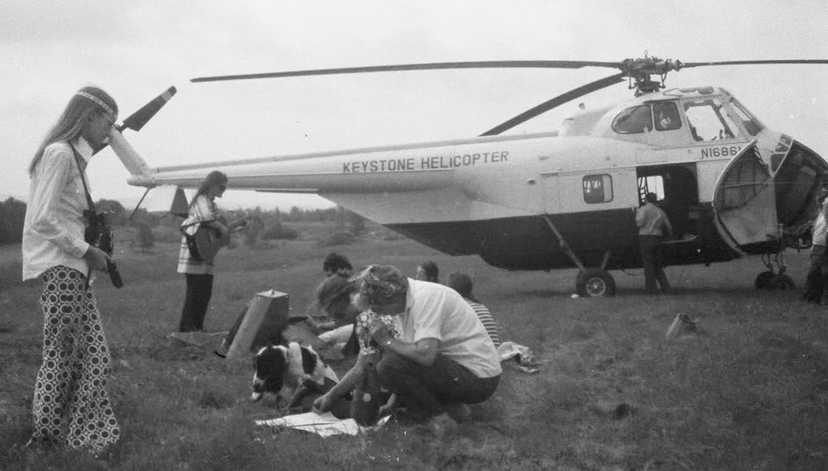
The only photo which has been located showing Grossinger's Airport in operation was a 1969 photo of a Keystone Helicopter Sikorsky S-58
which was used to fly musicians & promoters into the nearby Woodstock festival concert.
Ruth Huggler reported, “I'm in the photo, kneeling beside my mother. My sister is the girl at left with the camera.
My dad & another man ran the air service at the Liberty Airport in the 1960s.”
The date of closure of Grossinger's Airport has not been determined.
By 1972, Grossinger's Report had grown to 35 buildings on 1,200 acres that served 150,000 guests a year.
But multiple factors caused business to decline at Borscht Belt hotels in the late 1970s & 1980s.
In 1985, the Grossinger descendants sold the property to Hotels International,
but after aborted renovation attempts, Grossinger's main hotel & main resort areas closed in 1986.

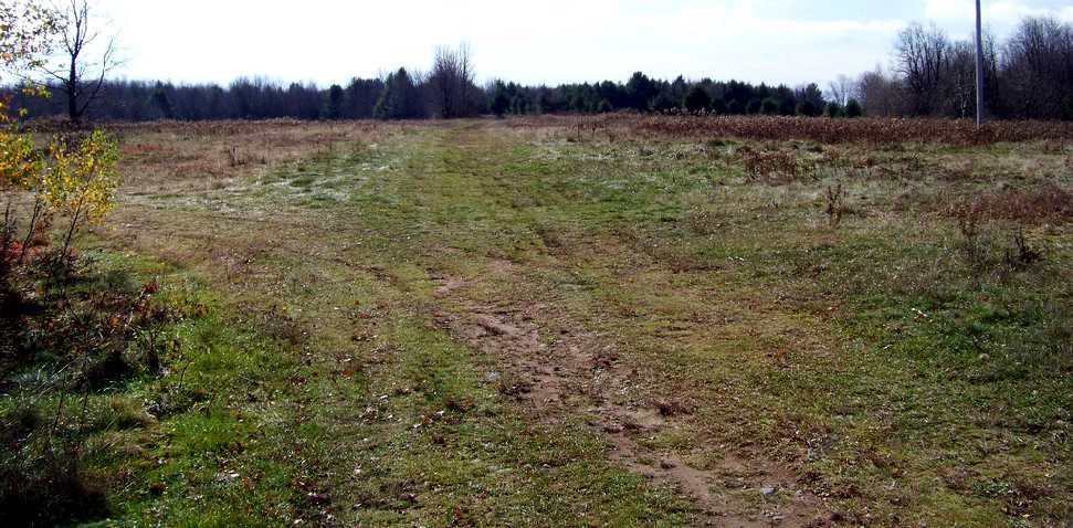
A 5/2/98 USGS aerial view looking north at the site of Grossinger's Airport showed the runway outline to be overgrown & barely recognizable.
A building located to the west of the runway may have been added after the closure of the airport.
A 11/12/08 photo showed the site of the Grossinger's runway.
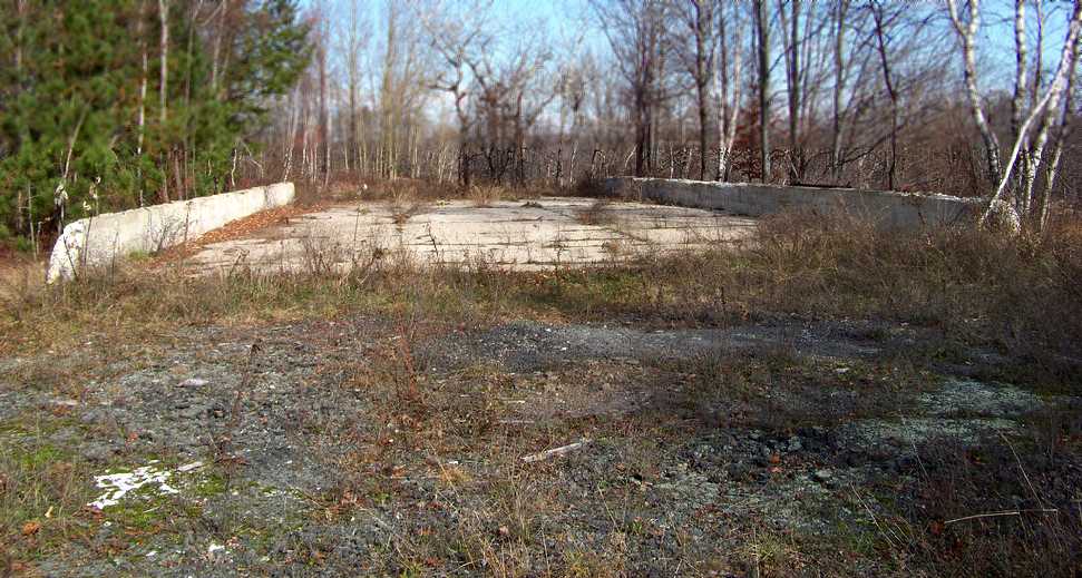
A 11/12/08 photo showed the foundation of the Grossinger's Airport hangar.

A 9/13/12 aerial view looking north at the site of Grossinger's Airport showed the runway outline to be overgrown & barely recognizable.
The site of Grossinger's Airport is located southeast of the intersection of Sunset Lake Road & Airport Road, appropriately enough.
Thanks to Tom Palmer for pointing out this airfield.
____________________________________________________
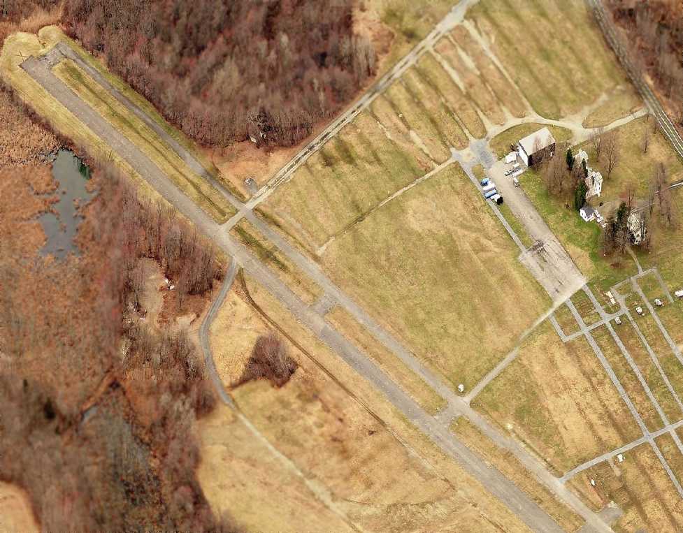
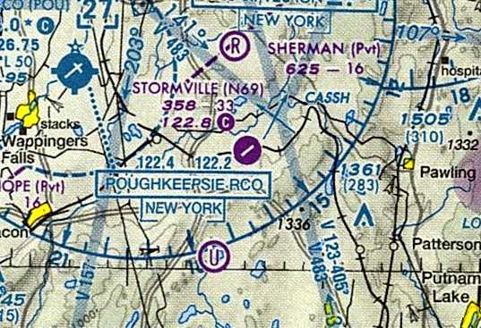
Stormville Airport (N69), Stormville, NY
41.577, -73.733 (North of New York, NY)
A circa 1943-45 aerial view looking north at Stormville Airport from the 1945 AAF Airfield Directory (courtesy of Scott Murdock).
According to Gilbert Halpin, "Stormville was purchased around late 1925 / early 1926 by Pete [O'Brien] & his brother Vincent.
It was purchased from the family of George Benjamin Foote.
Stormville officially became an airport in October 1927.”
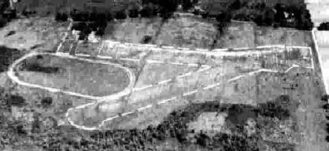
However, a 10/9/41 USGS aerial photo only depicted an oval racetrack at the site,
and according to its FAA Airport/Facility Directory listing, Stormville Airport was activated in 10/1942.
According to Peter Turecek (CAP Historian), “A NY Times obituary indicated a military funeral for a Lt. Waldo Gellard
killed in a plane crash 8/26/44 at Stormville while on a CAP mission.
The article hinted he might have been flying from the Flushing base on searchlight/antiaircraft target flights.”
According to J. Reicher, “Stormville Airport... is a historic airport where many of the famous old pilots used to fly.
It also was the closest airport in the New York area where you were allowed to fly during the Second World War due to security restrictions.
Many of the first women ferry pilots were trained there.”
The earliest depiction which has been located of Stormville Airport
was a circa 1943-45 aerial view from the 1945 AAF Airfield Directory (courtesy of Scott Murdock).
It depicted Stormville as having 2 grass runways, with an oval racetrack adjacent to the west side of the runways.

A 1943 photo of Elizabeth Gardiner in the rear seat of a Cub at Stormville. The photo was captioned, “Learning to fly at Stormville Airport.”

Stormville Airport was depicted on the 1948 USGS topo map simply as an open area, with a single building on the northwest side.

The earliest aeronautical chart depiction which has been located of Stormville Airport was on the July 1950 NY Sectional Chart (courtesy of Jim Stanton).
It depicted Stormville as having a 2,800' unpaved runway.
According to www.stormn69.org, “Stormville Airport was at one time a lively center for flying activity in the northeast.
Pete & Rose O'Brien ran the airport for 40 years with a flight school, tie downs, and maintenance facility.
Cole Palen, founder of the Old Rhinebeck Aerodrome, was a close friend of the O'Briens & flew there often.
He made a first flight of his restored 1909 Bleriot monoplane there.
He used to fly a Fleet biplane there in the 1950s, inviting young people to fly & inciting dreams.”

A circa 1955 photo of Cole Palen's restored 1909 Bleriot monoplane flying from Stormville Airport.

An 8/5/58 USGS aerial photo depicted Stormville as having 2 grass runways, with an oval racetrack adjacent to the west side of the runways,
and a dozen single-engine aircraft parked on the northwest side of the field.
R. Ritter recalled, “I can remember flying with [his father] up to Stormville Airport for his cross country flights
(cokes were 5 cents in the machine & a swimming hole).”

A 1968 photo of Glenn Kane in front of a Cessna 150 at Stormville Airport.
According to Gilbert Halpin, "The true heyday at N69 was between 1968-77.
More pilots were soloed & private pilot ratings were issued there then any other private field in the Hudson Valley.
1968 is the year that the modern backtop runway was completed & modern improvements of the period were installed,
before this time it was quite a small but intimate operation aircraft count wise.
I personally counted 92 general aviation aircraft based there in 1971,
however Pete has made claims that during this period as many as 116+ had been based there.”
A 1974 aerial photo depicted Stormville's newly-paved northeast/southwest runway,
with traces of the oval racetrack still visible, partly covered by the new runway.
The number of aircraft on the field had increased markedly compared to the 1958 aerial photo,
with several dozen aircraft parked all over the north side of the property.
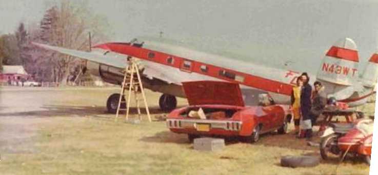
A 10/5/74 photo by Marty Tommer of a Lockheed 18-56, N43WT, S/N 2565, used at Stormville Airport to haul skydivers up to 12,500'.
According to Gilbert Halpin, "No true airport activity really had happened since 1983/84.”
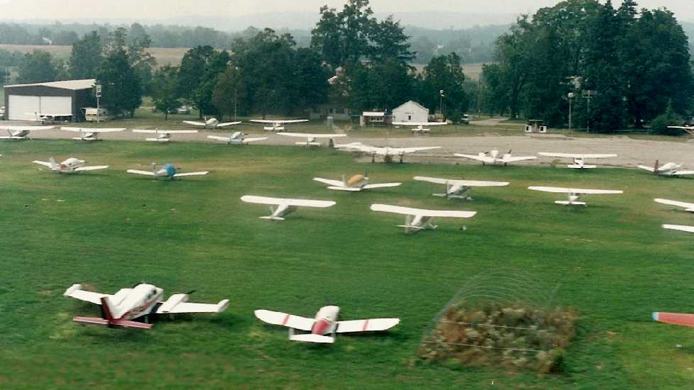
A 1986 aerial view of Stormville Airport by Ian Scott-Ramsay showed a very well-used airport.


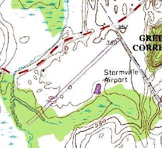
Stormville Airport, as depicted on the 1989 USGS topo map.
Paul Roggemann recalled, “I started taking lessons at N69 in January 1990.
I soled in February 1990 & had completed planning my first cross-country flight when they shut down the school.
This was around May 1990.
There were 2 Norwegian instructors there at the time working on their ATP tickets: One was named Frodde, and my instructor was Trond.
Sometimes I would fly back over to N69 & practice takeoff and landing, often stopping to chat with Pete or have a burger.
He was completing work on his biplane around that time.
N69 had a feel to it that I'm sure more seasoned aviators relish.
I can readily see why they liked it so much & I'm glad I got to spend some time there.
Every time I drive by Stormville it my brings back great memories.”
According to www.stormn69.org, “When Pete & Rose retired the airport passed to their daughter Patricia.
As late as 1990 there were a few planes still tied-down at the airport, but no fuel or services.”

The last photo which has been located showing aircraft at Stormville Airport was a 4/20/94 looking east,
showing 3-dozen light aircraft parked on the field.
According to Gilbert Halpin, "We officially went belly up at the end of 1995.”
Steven Styles remarked in 2006, “It is pretty hard to land with the flea market in effect every other weekend.”
Jack Downey reported in 2008, “Stormville... is still depicted on Sectional Charts as open - in fact there is still a GPS-A [approach] on the books -
but it looked pretty closed to me the last time I flew over it.
There are no airplanes based there anymore & I see there are now X's on the runways.”
A circa 2008-2011 aerial view looking west depicted a sad sight – the aviation facilities at Stormville remained completely intact,
but the field was completely devoid of any aircraft,
and instead displayed evidence of its usage for flea markets – the multiple paved road segments on the north side of the property.
Fred Robbins reported in 2009, “I used to take lessons there in the early 1970s there, spent many a weekend hanging out,
and then trained & flew aerobatics in many contests held by my dear, deceased friends
Daniel Héligoin & Montaine Mallet of the 'French Connection Airshow'.
It's only used now for several huge flea markets each year.
I only attended once several years ago & was terribly depressed.
Walking down the rows of booths on the asphalt, all I could think about was,
'I used to touch down right here...I used to rotate right about here...This is where I hit that crosswind gust... I used to taxi here...".”
Vin Soares reporteed in 2010, “I too hate to see this airport go.
I remember landing there in the late 1970s with my instructor from the old Danbury School of Aeronautics. Sad, very sad.
I received information from the FAA & the airport owners say that the field is open & they have no plans to close it.
This was a response to the FAA inquiry to the NY State Airport Department.
It is marked like it is closed & there have not been any NOTAMs so at this point I do not know what to think.”
Stormville Airport continued to be depicted as an open public-use airport on the 2011 NY Sectional Chart,
which is really a disservice to the aviation community if indeed the property no longer functions as an airport.
According to its FAA Airport/Facility Directory listing, as of 2011 Stormville Airport was still listed as “open to the public”,
with the owner & manager listed as Tom Carnahan.
The field was described as having comprising 155 acres, with a single 3,315' asphalt Runway 6/24, in “poor condition”, with “wide cracks & weeds on runway”,
but it was still listed as conducting an average of 33 takeoffs or landings per month.
As of 2011 www.stormn69.org reported, “Now the airport is left to the hand-me-downs & cast-aways of a consumer culture,
mouldering among picture puzzles with missing pieces, boxes of dime store paperbacks, grocery store china,
department store home furnishings, knick-knacks, and second-hand clothes.
It is the Stormville flea market.”
Stormville Airport is located southeast of the intersection of Route 216 & Brothers Road.
____________________________________________________
41.53, -74.207 (North of New York, NY)
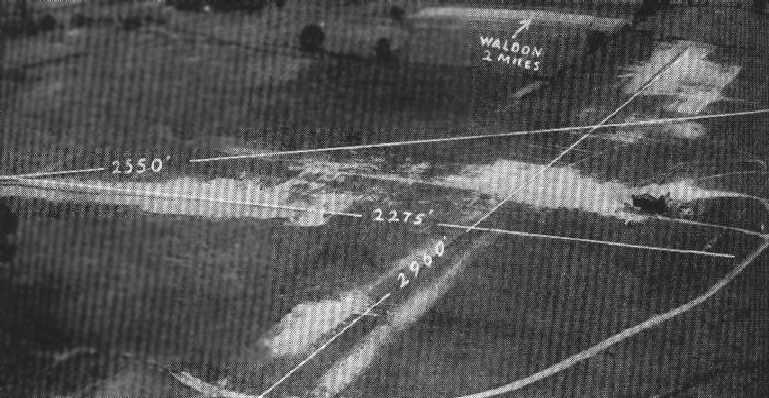
An undated aerial view looking northwest at Walden Airport,
from The Airport Directory Company's 1933 Airport Directory (courtesy of Chris Kennedy).
This general aviation airport was not yet depicted on the 1929 Rand-McNally Standard Map of NY with Air Trails.
According to James Stanton, “Walden Airport opened [on] Memorial Day 1931.”
According to an article in the 12/17/03 issue of the Times Herald-Record,
Pilot John Sanford recalled that “the Tillson-Walden Airport” was the de facto center of the regional aviation movement.
Charles Lindbergh & Amelia Earhart both made visits there.
John recalled, "I saw Lindy at the airfield.”
Sanford spent the early part of the 1930s learning to fly there
and his instructor was an Austrian pilot named Egan Pelzeder, a former World War I fighter pilot.
"A great fella... we were like 2 peas in a pod", Sanford said.
"He was my first serious instructor."
That teacher-student relationship endured for more than 18 months before ending with Pelzeder's death.
He died in a plane crash in 1931.
The earliest depiction of Walden Airport which has been located
was in The Airport Directory Company's 1933 Airport Directory (courtesy of Chris Kennedy).
It depicted Walden Airport as having 3 sod runways, with the longest being the 2,960' north/south strip.
The field was said to consist of a total of 96 acres, irregularly-shaped.
A single hangar was depicted just to the northeast of the runway intersection.
The operators were listed as Roy Munroe & Tillson Flying Service.
The field's owner & operator was listed as Earl Tillson.
The earliest aeronautical chart depiction which has been located of the Walden Airport
was on the 1935 10M Regional Aeronautical Chart (courtesy of Chris Kennedy).
It depicted Walden as a commercial/municipal field.

The 1942 USGS topo map depicted Walden Airport as having 3 unpaved runways, with a hangar just east of the runway intersection.

A 8/7/42 aerial view looking north from the 1945 AAF Airfield Directory (courtesy of Scott Murdock)
depicted Walden Airport as an open grass area with a building on the east side.
The 1945 AAF Airfield Directory (courtesy of Scott Murdock) described Walden Airport
as a 110 acre irregularly-shaped property having a sod all-way landing area, with the longest dimension being 3,200' north/south.
The field was said to have 3 metal & wood hangars, the largest measuring 100' x 30'.
Walden Airport was described as being owned & operated by private interests.

Ellen Stekert observed, “These photos show a young pilot, 15 years old, [Jim Stekert], whose parents took him to Walden for a flying lesson.
The boy had just taken a course in flying at Lafayette College in Easton, PA.
The father has annotated the snapshots. One picture shows the instructor, perhaps the owner of the field, starting the propeller on the Piper Cub the boy flew.”

Ellen Stekert recalled, “I had my first flight at that time - the instructor told me that I could wave the wings at my family when we were over them.
Of course he did not tell me how to do it, so I jiggled the stick back & forth abruptly - I think it just looked like a stutter. It did shake up the instructor.”

The 1946 USGS topo map depicted Walden Airport as having 2 runways, with a hangar just east of the runway intersection.

A 9/9/46 photo by Martin Stekert (courtesy of Ellen Stekert) of a Fairchild PT-19 at Walden Airfield.
According to Ellen Stekert, “This was taken after the son had turned 16 years old.
The father had worked in the early airplane industry in New Jersey during WWI & was determined to give his son the opportunity to become a pilot, an opportunity he had never had.
WW2 had just ended & the importance of the air industry was well noted by the father.
The family spent their summer vacation time at a farm near the Walden Airport that took in summer visitors (Lucht's Farm).”

The 1957 USGS topo map depicted the “Newburgh-Walden Landing Field” as having 2 unpaved runways,
with several small buildings just northeast of the runway intersection.
The area surrounding the field was already depicted as a golf course.
The last aeronautical chart depiction which has been located of the Walden Airport
was on the January 1958 NY Sectional Chart (courtesy of Chris Kennedy).
It depicted “Newburgh-Walden” as having a 3,000' unpaved runway.
Peter O'Brien recalled, “Walden Airport was one of my cross-country stops when I was learning to fly at Christie Airport in New City in 1958.
I remember when landing at Walden you had to look out for golfers who would at times cross the runway from one tee to the other.”

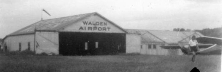
The last photo which has been located showing Walden Airport while still in operation was an 8/5/58 USGS aerial view.
It depicted a small hangar on the east side of 2 unpaved runways.
According to James Stanton, “Walden Airport closed 6/30/60.”
The Walden Airport was no longer listed among active airfields in the 1960 Jeppesen Airway Manual (according to Chris Kennedy).
Ken Barnes recalled, “While the airport was 'closed' for a while in the early 1960s (when my father owned the golf course)
planes still appeared now & then rather unexpectedly!
I remember being quite excited when a plane landed one day (quite unannounced) just a few yards from the 1st tee.
I don’t know who was more shocked:
the golfers or the pilot (who must have surely wondered where the windsock was)!”
A 4/2/74 USGS aerial view showed the hangars remaining, and the airport circle marking remained recognizable to the west of the hangars,
but there was no aircraft or other signs of recent aviation use.

The 1986 USGS topo map continued to depict Walden Airport's 2 runways, labeled simply as “Landing Strips”.
A 2003 aerial view showed the 2 grass runways of the former Walden Airport to remain clear, and the 1930s-vintage hangar remained standing as well.
As of 2006, road maps labeled the site of Walden Airport as the Scott's Corners Golf Course.

A circa 2008 aerial view looking north at the 1930s-vintage hangar which remains standing at the site of Walden Airport.
The site of Walden Airport is located northwest of the intersection of Route 208 & Route 17K.
____________________________________________________
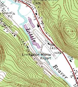
Livingston Manor Airport, Livingston Manor, NY
41.893, -74.82 (North of New York, NY)

Livingston Manor Airport, as depicted on the August 1938 NY Sectional Chart (courtesy of Chris Kennedy).
The Livingston Manor Airport was established by Harry Gordon in 1938,
according to an article in the 8/4/42 issue of the Rockaway Journal (courtesy of Jack Gordon).
The earliest depiction of Livingston Manor Airport which has been located
was on the August 1938 NY Sectional Chart (courtesy of Chris Kennedy).
It depicted Livingston Manor as an auxiliary airfield.
The Airport Directory Company's 1938 Airport Directory (courtesy of Chris Kennedy)
described Livingston Manor as an auxiliary airfield, having a single 1,566' north/south sod runway.
The article in the 8/4/42 issue of the Rockaway Journal (courtesy of Jack Gordon)
described how the Livingston Manor Airport was abandoned by Harry Gordon in 1939
when he decided to open the Rockaway Airport in Queens.
The Livingston Manor Airport may have continued to operate even after Harry Gordon had moved his operations away,
as Livingston Manor was still listed as an active airport in The Airport Directory Company's 1941 Airport Directory (according to Chris Kennedy).
It described Livingston Manor as an auxiliary airfield, having a single 1,566' north/south sod runway.
Harry Gordon relocated his flight school operation back to Livingston Manor,
after the Rockaway Airport was closed to civilian flight operations on August 3, 1942
due to an Army order closing all privately operated airfields
within a radius of 200 miles of the coastline "for the duration" of the war.
Jack Gordon recalled, "We flew all of our aircraft to Livingston Manor Airport, in the Catskill Mountains."
The field at Livingston Manor Airport was described as being 3,500' in length,
according to the article in the 8/4/42 issue of the Rockaway Journal (courtesy of Jack Gordon).
The airport was said to have "a number of cottages in which student pilots will reside while taking the course.
Over 125 have already agreed to continue their studies at Livingston Manor."
No airfield at Livingston Manor was depicted on the 1945 NY Sectional Chart
nor listed in the 1945 AAF Airfield Directory (courtesy of Scott Murdock)
(perhaps it was just overlooked due to its relatively small size).
The January 1949 NY Sectional Chart (courtesy of Chris Kennedy)
depicted Livingston Manor Airport as having a 2,400' unpaved runway.
The 1952 NY Sectional Chart (courtesy of Mike Keefe)
depicted Livingston Manor as having a 2,600' unpaved runway.

A 1957 photo of Albert 'Put' Gottlieb making the 1st flight of a homebuilt at Livingston Manor Airport (courtesy of Bill Gottlieb).
An undated photo of an Aeronca on skis at Livingston Manor Airport (courtesy of Bill Gottlieb).

A 1962 aerial view looking northwest at Livingston Manor Airport (courtesy of Bill Gottlieb).
The 1962 AOPA Airport Directory described Livingston Manor
as having a single 2,600' sod Runway 14/32.
The field was said to offer fuel, minor repairs, hangars, tiedowns, and charter.
The operator was listed as Livingston Manor Airport Inc.

A 5/2/63 USGS aerial view depicted Livingston Manor Airport as having a single unpaved runway.
Bill Gottlieb recalled, “My father, Albert 'Put' Gottlieb & his brother, Manuel 'Manny' Gottlieb
owned & operated the strip during the 1960s & early 1970s.
Put was a flight instructor (he flew P-39s, P-40s & P-51s during WWII) & Manny was an A&P mechanic.
Besides running the airport, they owned & operated several dealerships out of the buildings
including Cessna, Case (tractors), Willy's (Jeeps), and Ski-Doo (snowmobiles).
The Army Guard & Reserve used it frequently during exercises while it was open.”
Livingston Manor was still depicted as a public-use airport on the 1965 NY Sectional Chart.

The 1965 USGS topo map Livingston Manor Airport as having a single northwest/southeast unpaved runway,
with several small buildings along the east side of the runway.
An undated aerial view looking south at Livingston Manor Airport (courtesy of Bill Gottlieb).
Bill Gottlieb recalled, “They [Put & Manny Gotltlieb] sold the airport in 1970 and moved to Daytona Beach, Florida.
When the new owner passed away shortly afterwards,
Dad & Uncle Manny bought it back from the widow until it could be sold again.”

Livingston Manor was still depicted as a public-use airport in the 1972 Flight Guide (courtesy of Chris Kennedy).
The field was depicted as consisting of a single 2,400' unpaved Runway 15/33,
with 3 buildings along the middle of the northeast side of the runway.

Livingston Manor apparently became a private field at some point between 1972-75,
as that is how it was depicted on the 1975 NY Sectional Chart (courtesy of Mike Keefe).
It was described as having a 2,400' unpaved runway.
The 1982 USGS topo map Livingston Manor Airport
as having a single northwest/southeast runway, with 2 small buildings along the east side of the runway.
The 1982 AOPA Airports USA Directory (courtesy of Ed Drury)
described Livingston Manor Airport as having a single 2,600' turf Runway 15/33.

Livingston Manor Airport may have been closed at some point between 1982-86,
as the 1986 USGS topo map labeled it merely as "Landing Strip" (which typically indicated an airport which was no longer operational).

As seen in the 1993 USGS aerial view,
Livingston Manor Airport appeared completely intact, including the single grass runway, and 2 hangars on the east side of the field.
However, there was no sign of any aircraft, or any other indication of recent usage.

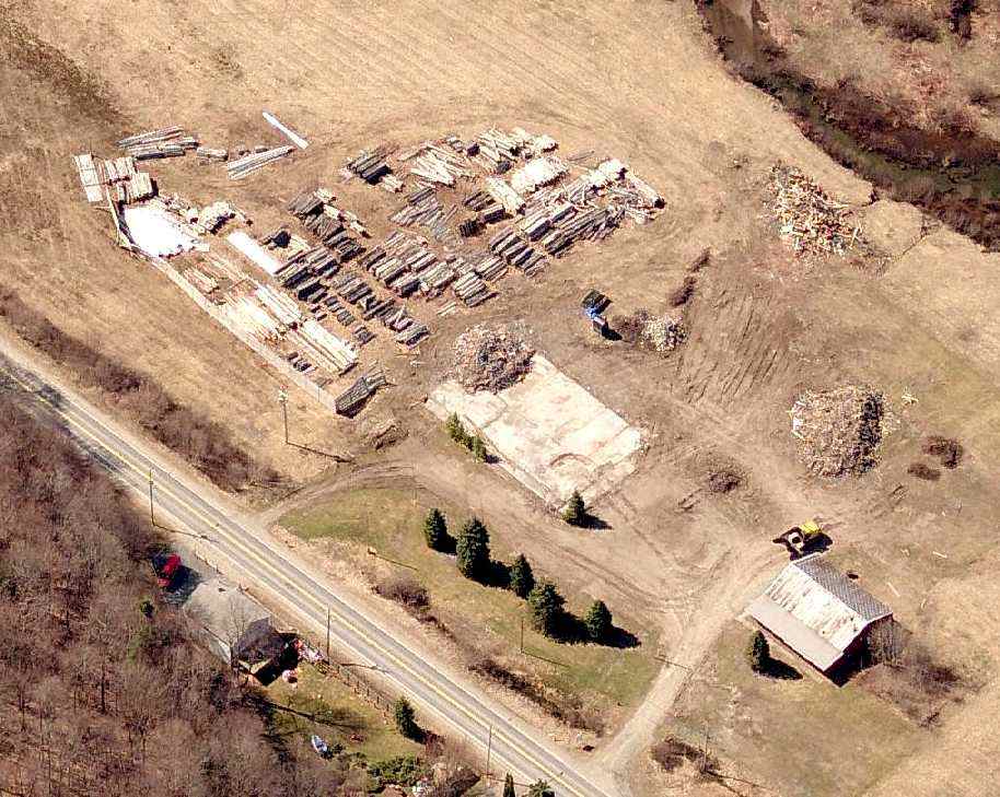
A circa 2006 aerial view looking south at the former Livingston Manor Airport,
showing the 2 airport buildings while they both remained standing.
While the grass runway remained intact, unidentified objects were being stored on the runway southeast of the buildings.

A photo of the fire which consumed the main building at the former Livingston Manor Airport on January 27, 2007 (courtesy of Bill Gottlieb).
Renovation work was being done on the 2 buildings recently, among which was the replacement of the roof shingles on the main building.
When a predicted cold front passed through with the accompanying gale winds, workers retired from the roof to take an early lunch break.
During their absence, smoke was observed coming from the building by passing motorists.
By the time firemen arrived at the scene, the flames, stoked by the winds, had already ate through the roof,
and by the time the blaze was under control, the building was completely burned out.
The remaining structure has quickly since been knocked down.
Today the old building, which once housed the original airport offices, repair shops and Jeep dealership of the Gottlieb brothers
is now a pile of smoldering debris.
A circa 2008 aerial view looking south at the former Livingston Manor Airport,
showing the remains of the main airport building which burned in 2007.
The site of Livingston Manor Airport is located on the southwest side of Route 178,
southeast of its intersection with Pearl Street.
____________________________________________________
Black Pond Airfield, Farmer's Mills, NY
41.506, -73.762 (North of New York, NY)
USGS aerial photo 1993.
Not much is known about this unusual little airport,
including its actual name, or date of construction.
The Black Pond Airfield was evidently built at some point between 1974-93,
as it did not yet exist in a 1974 aerial photo.
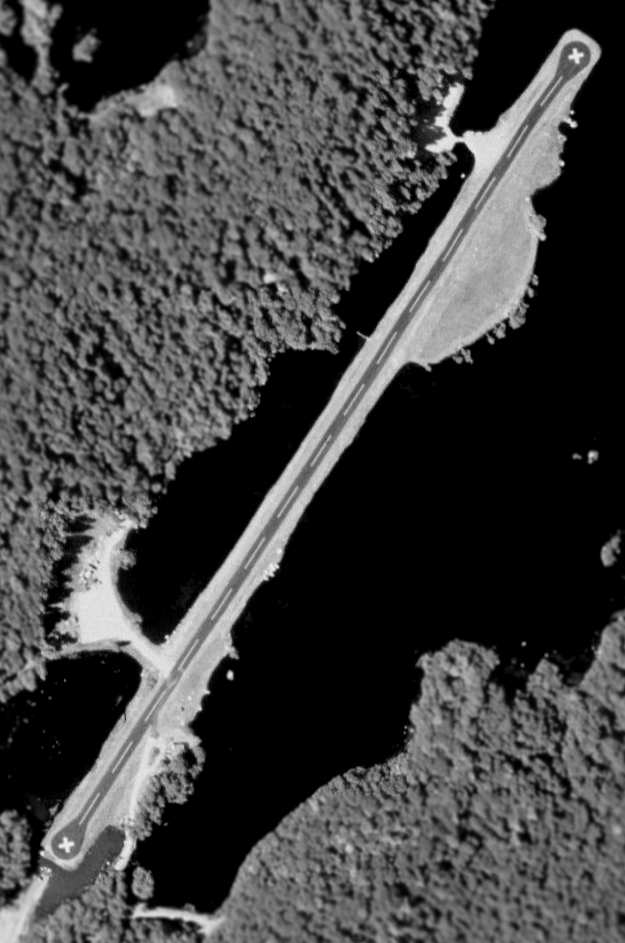
The earliest depiction which has been located of the Black Pond Airfield was the 1993 USGS aerial photo.
It showed the field to have a single 3,300' paved runway,
which was apparently constructed on filled-in land in the middle of the lake.
Closed runway "X" symbols are prominently displayed on both ends of the runway.
The airfield does not appear to be very old, as the pavement & markings appear to be relatively recent.
There do not appear to be any hangars or other aviation facilities.
Why was so much effort spent to construct this runway in the middle of the lake,
instead of just clearing a patch of land alongside the lake?
No airfield at all was depicted on the site on the 1975 NY Sectional Chart (courtesy of Mike Keefe),
or the 1975, 1981, or 1993 USGS topo maps.
Indeed, even the filled-in land on which the runway was built was not depicted on the topo maps.
Ian Baren reported in 2004, "The story I heard about Black Pond
was that the president of the local bank built it for his own use –
there is a modern metal hanger on the northeast side.
I’ve never seen any plane(s) there though."
Jeff Green reported in 2005, “The land around Black Pond, the pond, and the landing strip all belong to Dean & Wayne Ryder,
owners of the Putnam National Bank.
PNB has been around since the middle of the 1800's & the family has owned this land since then.
It [the airfield] sits a few hundred feet from my home.
Frequently on Saturday mornings Wayne (or is it Dean) goes flying or his friends come to visit.
He's got a propjet of some sort, hence the length of the runway.
The runway was built by draining Black Pond then filling in the subsurface for the runway
which now connects several small 'islands' that were in the pond.”

A circa 2006 aerial view looking north at the south end of the Black Pond Airfield
showed 2 improvements which were added at some point between 1993-2006:
a slight lengthening of the runway & the addition of a hangar.

A 2009 aerial view by Timm Holzhauer looking west at the Black Pond Airfield.
Tim observed, “There are 3 Beechcraft King Air 100 (low tail, that's why they're relatively easy to recognize) parked in front of this pretty cool airstrip.”
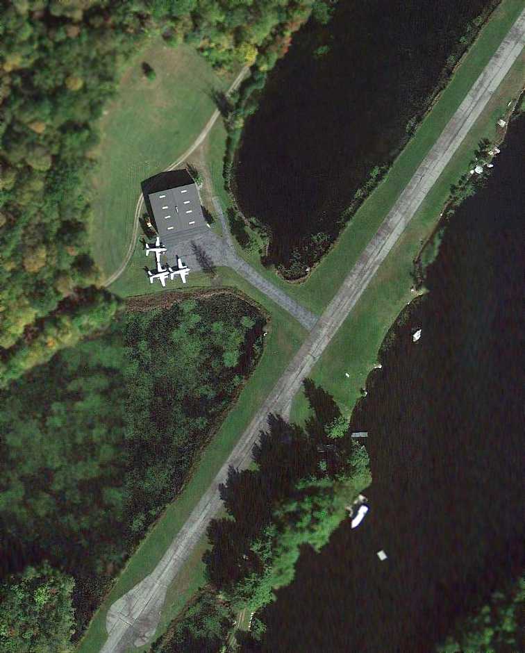
A 10/8/11 aerial view showing the 3 Beechcraft King Air 100 twins parked at Black Pond.

A 12/3/11 aerial view by David Horvath looking east at the Black Pond Airfield.
The Black Pond Airfield is located a half-mile east of the intersection of
Rushmore Road & Memory Lane.
____________________________________________________
Wallkill Auxiliary Army Airfield #2 / Galeville Airport / Wallkill Airport /
Ulster County Airport / Galeville Army Airfield, Galeville, NY
41.637, -74.211 (North of New York, NY)

A circa 1942-45 aerial view looking north at “Stewart Field Auxiliary #2 (Wallkill Field)”
from the 1945 AAF Airfield Directory (courtesy of Scott Murdock).
This small Army Airfield was used during WW2 as Wallkill Auxiliary Army Airfield #2,
one of 3 satellite airfields for Stewart AAF,
which provided basic & advanced flight training for the cadets of the nearby US Military Academy at West Point.
The date of construction of Galeville has not been determined.
It was apparently built at some point between 1943-44,
as it was not depicted at all on the 1943 NY Sectional Chart (according to Chris Kennedy).
The earliest reference to the field which has been located
was in the 1944 US Army/Navy Directory of Airfields (courtesy of Ken Mercer).
It described "Wallkill U.S. Military Academy Aux #2" as having a 3,500' hard-surfaced runway.
The earliest photo which has been located of “Stewart Field Auxiliary #2 (Wallkill Field)” was a circa 1942-45 aerial view looking north
from the 1945 AAF Airfield Directory (courtesy of Scott Murdock).
It depicted the field as having 2 paved runways.
The 1945 AAF Airfield Directory (courtesy of Scott Murdock) described “Stewart Field Auxiliary #2 (Wallkill Field)”
as a 677 acre irregularly-shaped property having 2 concrete 3,500' runways, oriented north/south & east/west.
The field was said to not have any hangars,
to be owned by the U.S. Government, and operated by the Army Air Forces.
The earliest aeronautical chart depiction which has been located of this airfield was on the 1945 NY Sectional Chart.
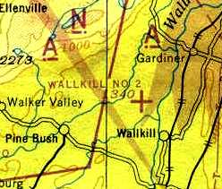
It depicted "Wallkill #2" as an auxiliary airfield.
The Galeville airfield may have seen some use in the post-WW2 period as a civilian airport,
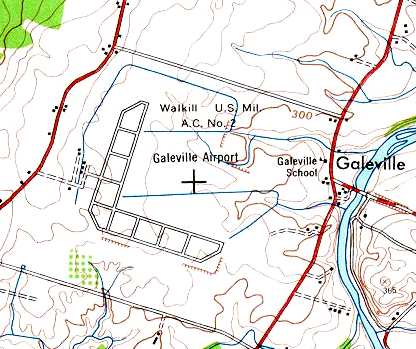
as it was labeled both "Galeville Airport" & "Walkill US Mil. A.C. #2" on the 1946 USGS topo map.
It was labeled "Walkill" on the 1949 NY Sectional Chart (according to Chris Kennedy),
and described as having a 3,500' hard-surface runway.
The 1950 NY Sectional Chart (courtesy of Mike Keefe) depicted it under yet another name, "Ulster Co".
"Ulster Co" Airport, as depicted on the January 1955 NY Sectional Charts (courtesy of Chris Kennedy).
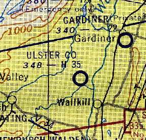
The Ulster County Airport was apparently closed at some point between 1955-57,
as it was not depicted at all on the 1957 NY Sectional Chart (courtesy of Mike Keefe).

An 8/5/58 USGS aerial photo showed no indication of any recent aviation usage of the Galeville airfield.
The Galeville airfield has been used by the Army in the post-WW2 period for special operations & parachute drops.
A 1969 aerial view of Ted Frison looking southeast at the Walkill / Galeville Airfield.
Ted recalled, “This was taken from a Huey as we approached for a [parachute] jump. As you can see, by 1969 we had the airfield to ourselves.”
A 1970 photo of Ted Frison making a parachute drop using an experimental parafoil onto the Walkill / Galeville Airfield.
Ted recalled, “In 1970 I was a West Point cadet. We were using Wallkill as the drop zone for the parachute club/team.
We were helping to develop a new type of parachute that we called the parafoil.
Our variant was invented by John Nicolaides. I got to jump his first prototype & then went on to jump with the D-200.
The problem we were trying to solve was how to get it out of the backpack without it self destructing.
We jumped from Hueys & a Twin Beaver based over at Stewart. I don’t remember ever seeing any other aircraft on the field.”

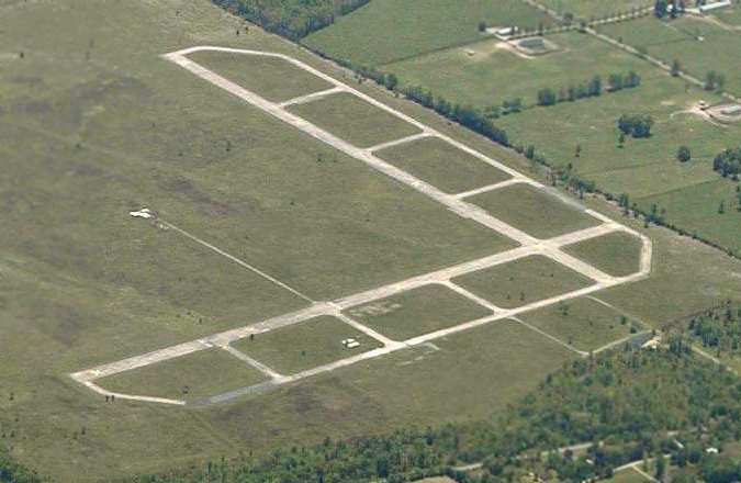
A 4/27/74 USGS aerial photo showed no indication of any recent aviation usage of the Galeville airfield.
The 1986 USGS topo map depicted the 2 runways of the “Galeville Army Airport”.
According to Steve Miller, "Galeville Airport, better know to us as 'the Drop Zone',
was also used in the 1980s & 1990s for an automotive competition called autocrossing.
It was one of the best sites in the northeast, and whenever there was an event there, people came from all over.
The Northeast Division of SCCA held their Divisional Championships there at least 3 years in the 1990's.
We held autocrosses there on one side while the flying club held meets on the other side.
I thought it interesting that the 'gentleman' horse farmers (more likely a bunch of millionaires who bought the farms for tax reasons)
are afraid of airplane noise when there is a shooting range within earshot of the airport."
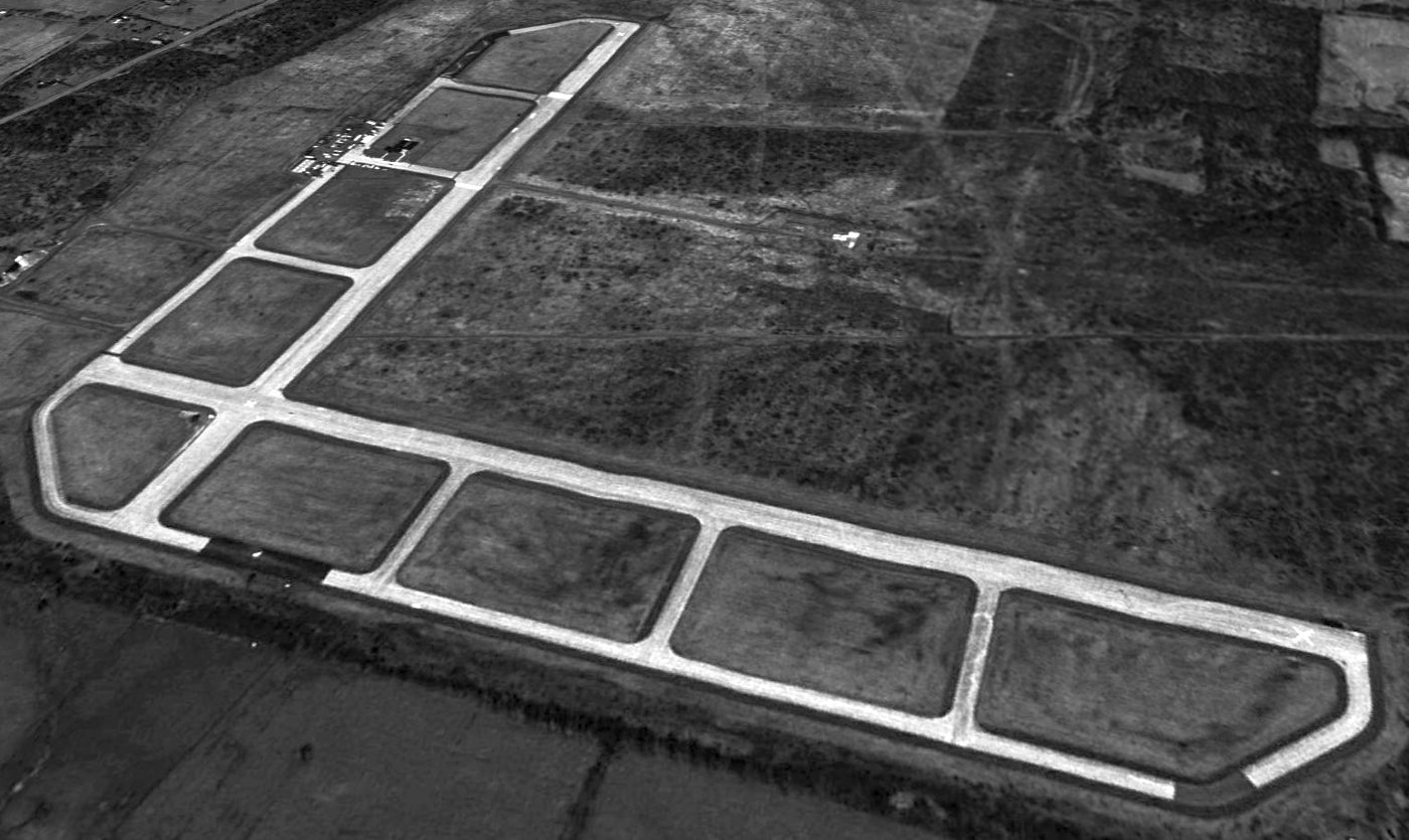
As seen in a 1994 USGS aerial view looking north, the Galeville airfield remained intact.
The Galeville airfield was determined to be surplus in 1994,
but a property named the "Galeville Training Site" was still listed as a active army facility in 1999.
Tim Tobin reported that "Eight years ago [1995] I was in NY & flying around that area,
and Galeville was a very important field for all local aviators.
First of all the field was maintained up until about 9 years ago by the FBI
who used the runways to teach agents driving techniques.
Also the Army Reserve Air Ambulance squad I was a member of went to Galeville frequently
for weekend training missions because of the closeness to Stewart Airfield in Newburgh,
where the Pegasus Dustoff unit was stationed."
Tim continued, "I was also a Lt. in the Civil Air Patrol & I approached the towns people in Galeville
on behalf of the CAP to propose that the airfield be converted to a CAP training facility
and airfield for CAP planes (It would have been ideal for that).
The townsfolk came out of the woodwork to protest the use of the field for aircraft
because of the horse farms nearby.
They had a fear that the loud nasty planes would scare the thoroughbred horses.
I kept up & it was written up in the local papers
about how the military was going to disrupt the peace of the area!
I had to move before the project was completed & I guess,
given the information you have published, for some reason the CAP abandoned the idea.
Galeville is a local landmark for area pilots as it is highly visible for miles
and a local airport that has an EAA group that specializes in aerobatic planes
uses the airspace above Galeville for their practice area."
Local model aircraft enthusiasts were permitted by the Army to use the runways for nearly 30 years.
However, that arrangement was ended when control of the property was transferred in 1999 to the US Fish & Wildlife Service,
which now refers to the property as the Shawangunk Grasslands National Wildlife Refuge.
The local government is attempting to redevelop the property as a park.

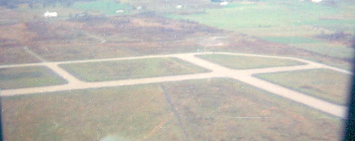
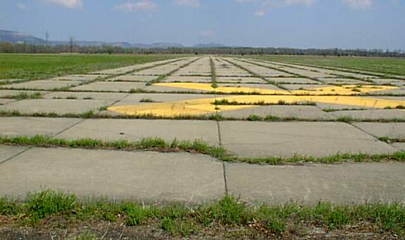
A 2002 photo by Charlie Helms looking north along Galeville's North/South runway.
Charlie reported, “No buildings remain at the airfield.
It really would have made an awesome airport for public use, all concrete runways & taxiways.
I walked it & it has very large commercial airport feel & size.
It is definitely a military-built facility, looks like no expense was spared in it's construction.
It would be a perfect county airport & would need little repair.
The runway system is just a little grassy in the joints, but still very even & in good condition.
The locals I talked to have no memories of any airplane flying out or to it.”
A 2002 photo by Charlie Helms looking east along Galeville's East/West runway.
A 2003 aerial view looking southeast at Galeville by Pierre-François Mary.
Rich Peabody reported in 2004 that "I have visited the Galeville site a couple of times.
The Academy of Model Aeronautics has been involved, at various levels at different times,
in trying to have the facility dedicated to model aviation activities.
During a 2 day adventure there (it's a pretty good hike into the property),
I was challenged by suit-types, who got fairly frantic.
The previous day I had watched several suits driving Suburbans,
doing 'moonshine' turns & the like, while I was measuring the runway width & sketching the property.
There were several smaller outbuildings on the southeast side of the field that appeared very much in use...
glass in windows, grass not grown up on sills, etc.
The next day the suits made it very clear that I was not wanted there.
Several locals at an eatery reported to me that they thought that nearby West Point must use the place from time to time,
because buses & Suburbans were there frequently.
The AMA's efforts have been frustrated because the Federal Government
apparently offers excess properties to other Government agencies,
and the BLM wants the site as a bird sanctuary."

A 2009 aerial view looking north showed the Galeville runway & taxiway pavement was still intact.
A 2010 photo by Seth Gruver of the demolition of the Galeville runways.
Seth reported, “The pavement is being torn up.
The Fish & Game Department claims that the demolition will 'improve drainage' on a site that seemingly no one is allowed onto.”
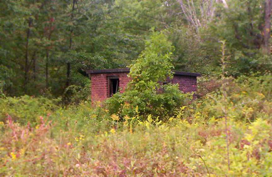
A 2010 photo by Seth Gruver “of a shack of unknown construction spotted near the entryway” to the Galeville airfield.

A 2016 aerial view looking north showed that every bit of Galeville's aviation infrastructure had been wiped from the landscape.
See also: http://ny.audubon.org/iba/galeville.html
____________________________________________________
Since this site was first put on the web in 1999, its popularity has grown tremendously.
That has caused it to often exceed bandwidth limitations
set by the company which I pay to host it on the web.
If the total quantity of material on this site is to continue to grow,
it will require ever-increasing funding to pay its expenses.
Therefore, I request financial contributions from site visitors,
to help defray the increasing costs of the site
and ensure that it continues to be available & to grow.
What would you pay for a good aviation magazine, or a good aviation book?
Please consider a donation of an equivalent amount, at the least.
This site is not supported by commercial advertising –
it is purely supported by donations.
If you enjoy the site, and would like to make a financial contribution,
you
may use a credit card via
![]() ,
using one of 2 methods:
,
using one of 2 methods:
To make a one-time donation of an amount of your choice:
Or you can sign up for a $10 monthly subscription to help support the site on an ongoing basis:
Or if you prefer to contact me directly concerning a contribution (for a mailing address to send a check),
please contact me at: paulandterryfreeman@gmail.com
If you enjoy this web site, please support it with a financial contribution.
please contact me at: paulandterryfreeman@gmail.com
If you enjoy this web site, please support it with a financial contribution.
____________________________________________________
This site covers airfields in all 50 states.