Abandoned & Little-Known Airfields:
New York State, Westchester County
© 2002, © 2016 by Paul Freeman. Revised 6/17/16.
This site covers airfields in all 50 states: Click here for the site's main menu.
____________________________________________________
Please consider a financial contribution to support the continued growth & operation of this site.
Barrett Field / Westchester Aviation Country Club Airport / Armonk Airport (revised 6/7/16)
Croton Airpark (revised 6/17/16) - La Roe Airport / Bedford Airport (added 11/7/15) - Somers Airport (revised 10/2/15)
____________________________________________________
La Roe Airport / Bedford Airport, Bedford, NY
41.2, -73.65 (North of New York, NY)
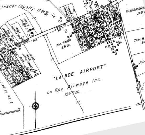
“La Roe Airport”, as depicted on a circa 1930 Westchester County map (courtesy of Thomas Genett).
This small small general aviation airport was evidently established at some point between 1925-29,
as it was not yet listed among active airfields in the 1925 Commerce Department Aeronautical Bulletins (courtesy of Jonathan Westerling).
La Roe Airport was started was Dr. K. La Roe & later operated by Webster Schmaling, according to a 1935 NY Times Article.
The earliest dated reference which has been located of La Roe Airport was that German parachutist Paul Wintermeyer was killed there in 1929 when his parachute failed to open,
according to “Westchester: A Portrait of a County” by Alex Shoumatoff.
The earliest depiction which has been located of La Roe Airport was a circa 1930 Westchester County map (courtesy of Thomas Genett),
which depicted “La Roe Airport”, owned by Le Roe Airways Inc, and comprising 124 acres.
The airport was depicted as being irregularly-shaped, with a complex of many small buildings on the northeast corner.

A circa 1930 Westchester County map (courtesy of Thomas Genett) depicted “Le Roe Airport” (a misspelling),
owned by Le Roe Airways Inc, and comprising 124 acres.
Thomas Genett reported, “I [have] a receipt for my father's first airplane ride.
It was from a company called Mars Flying Service, Bedford Village, NY. In my father's handwriting it noted his first airplane ride 1930 Bedford Airport.”

A circa 1930s photo of an unidentified group of pilots in front of a biplane at La Roe Airport (courtesy of Ian Baren).

A circa 1930s photo of pilot James McClean sitting on a plane at La Roe Airport (courtesy of Ian Baren).
Amid neighbor noise complaints & the Depression-era economy, La Roe Airport closed in the mid-1930s,
according to a written history by Robert Kelly.
Bedford Airport was no longer listed among active airfields in the 1945 AAF Airfield Directory (courtesy of Scott Murdock).
The 1955 USGS topo map depicted the site of La Roe Airport as “Memorial Field”.

A 2014 aerial view showed no trace remaining of La Roe Airport.
As of 2015, street maps labeled the site of La Roe Airport as Bedford Village Memorial Park.
The site of La Roe Airport is located at the southern terminus of Jefferson Lane.
Thanks to Thomas Genett for pointing out this airfield.
____________________________________________________
41.32 North / 73.68 West (North of New York, NY)

A 10/20/41 USGS aerial view of Somers Airport.
The date of establishment of this small general aviation airport has not been determined.
The earliest depiction which has been located of Somers Airport was a 10/20/41 USGS aerial photo.
It depicted Somers as having 2 unpaved runways, with a few small buildings & 2 light single-engine aircraft on the west side.
Somers Airport was not depicted on the 1944 USGS topo map or on the 1945 AAF Airfield Directory (courtesy of Scott Murdock).
It may have gone through a period of closure during WW2,
like many other small general aviation airports near the coasts during the war.

The earliest topo map depiction which has been located of Somers Airport was on the 1946 USGS topo map.
Victor Sedrick recalled of Somers Airport, “My father Arthur Sedrick gave me my first airplane ride there when I was about 1 or 2 years old in 1946 or 1947.
He managed this airport for a time in the late 1940s.
There were no lights or radio at the field in the beginning necessitating autos lined up along the runway for late arriving aviators.
Dad flew J-3's, Aeronca's and Tri-Pacer's mostly.”
Robert Booth recalled, “In the Summer of 1949 I took some flying lessons, my first, at an airport in Somers, NY.
At about the same time there was also a 9-hole golf course on the site, just south of the famous 'Elephant Hotel' on Route 22.
This was a very makeshift operation, with just one J-3 Cub & the operator of the airport.
It might not have been an actual airport, just a pasture with an airplane.
I was a teenager without money & he had a program of numerous short flights for people in my situation.
I didn’t get any ground school & there was no curriculum. In a few weeks I made 7 dual flights of 10-25 minutes; I had 2:00 total.
I don’t remember the instructor’s name; he didn’t sign my logbook. It was not a very sophisticated operation!”
Joe Rao recalled, “I got my most memorable first ride in an airplane at Somers... two half-hour dual hops.
Somers was just a sod field at the top of rolling flat-topped hill about 100' above Route 100.
It was open from about 1941 to about 1947.
They had a surplus North American BT-9 parked there in the weeds... bad shape... dead battery...
don't know how it managed to land there at that small field.
Charlie Broncek, my instructor, and I managed to hand prop start the thing... it ran very rough... I believe it was broken down & scrapped.”

The earliest aeronautical chart depiction which has been located of the Somers Airport was on the 1950 NY Sectional Chart (courtesy of Mike Keefe).
It depicted Somers as having a 2,200' unpaved runway.

The last depiction which has been located of the Somers Airport was on the 1956 USGS topo map.
The earliest photo which has been located of the Somers Airport was a 1958 aerial view.
It depicted an open irregularly-shaped grass field with a few small buildings on the west side.
There were no aircraft visible on the field, or any other indication of recent aviation usage.
Somers Airport was evidently closed (for reasons unknown) at some point between 1956-60,
as it was no longer depicted on the 1960 USGS topo map.
A 1974 aerial photo depicted the site of Somers Airport in much the same manner as the 1958 photo.
The IBM Somers Office Complex was constructed between 1984-89 on the site of the Somers Airport,
a $55 million complex which enabled the centralization of 3,000 employees located in other facilities in the surrounding area.
Ironically, this resulted in the resumption of an aviation facility on the property,
as IBM maintains the private Somers Heliport (NY44).
A 1993 USGS aerial photo depicted the IBM office complex, without any trace remaining of the former airport.

A 6/18/10 aerial photo depicted the IBM office complex, without any trace remaining of the former airport.
The site of Somers Airport is located northeast of the intersection of Route 100 & Goldens Bridge Road.
____________________________________________________
41.235, -73.85 (North of New York, NY)

Croton Airpark, as depicted on the July 1950 NY Sectional Chart (courtesy of Jim Stanton).
This general aviation airport was evidently established at some point between 1945-53,
as it was not yet depicted on the 1945 NY Sectional Chart.
The earliest aeronautical chart depiction which has been located of the Croton Airpark
was on the July 1950 NY Sectional Chart (courtesy of Jim Stanton).
It depicted Croton as having a 1,400' unpaved runway.

The earliest photo which has been located of Croton Airpark was a 4/15/53 USGS aerial photo.
It depicted the field as having a very short unpaved northeast/southwest runway,
with 6 single-engine aircraft parked near some small buildings on the northwest side.

The 1955 USGS topo map depicted Croton as a single unpaved northeast/southwest runway, labeled simply as “Landing Field”.

A 3/3/64 USGS aerial photo depicted 8 single-engine aircraft at Croton Airpark.

The last aeronautical chart depiction which has been located of the Croton Airpark was on the 1965 NY Sectional Chart.
It depicted Croton as having a 1,400' unpaved runway.

A September 1968 photo of John Steiner “flying” a J3 Cub at Croton Airpark.
John Steiner recalled, “In the late 1960s my father used to fly a Piper Cub from a small field near the reservoir in Croton.
I have fond memories of him taking me flying.
I remember being there once when I was very small & it must have still been open (late 1960s) and there had been a crash.
I believe a man was killed when he overshot the runway.”
According to Ian Baren, “My best friend John was at the airstrip for a small airshow circa 1970-73.”
Berl Brechner reported, “Croton Airfield... was an active airport until mid-1970s or so.
A lot of NY-area folks flew from there.”
According to John Steiner, “I think it closed in the 1970s.”

A circa 1973-74 photo looking west at John Steiner riding a 1970 Benelli Buzzer minibike on the Croton Airpark runway,
with several nearly fallen-down hangars in the background.
John recalled, “It had a single paved runway. There used to be folks who flew model airplanes on the weekends.
My brother & I used to go there and ride mini-bikes.”
A 1974 aerial photo showed Croton Airpark having a single paved northeast/southwest runway,
with a few small buildings on the north side.
But there were no aircraft visible or any other signs of recent usage.
Berl Brechner reported, “I went to the runway, asphalt beginning to crack, in the late 1970s,
and on that occasion a lone flier of a powered ultra-light was using the now-closed runway.”

The last depiction of Croton Airpark which has been located was on the 1979 USGS topo map
(although that does not prove it was still open at that point).
It depicted the field as having a single unpaved northeast/southwest runway.
The 1993 USGS aerial picture showed no remaining trace of the former Croton Airpark,
with the runway having been replaced with a residential street, Longview Road.

A 2014 aerial photo showed no remaining trace of the former Croton Airpark.
____________________________________________________
Barrett Field / Westchester Aviation Country Club Airport / Armonk Airport, Armonk, NY
41.12, -73.71 (North of New York, NY)

An August 1928 photo of Charles Lindbergh landing in his Ryan at Armonk Airport (courtesy of the North Castle Historical Society, via Kenneth Hudson).
This airport was adjacent to the southeast side of the town of Armonk.
The date of construction of the Armonk Airport has not been determined,
but according to an article in the 12/17/03 issue of the NY News,
Charles Lindbergh flew into the Armonk airport in August of 1928
and greeted hundreds of well-wishers there who found out about his arrival.
It was also reported to have been visited by Amelia Earhart.

An August 1928 photo of Charles Lindbergh's Ryan at Barrett Field during his overnight visit,
along with 8 biplanes in front of the Barrett Field hangar (courtesy of the North Castle Historical Society, via Kenneth Hudson).

The location & layout of Barrett Field, as depicted on a 1929 NY Legislative Report (courtesy of Tom Heitzman).
It described the Armonk “Barrett Field” as being a 68 acre irregularly-shaped sod field having 2 runways,
the longest measuring 2,500' north/south.
The field was said to be leased from D.J. Barrett, and operated by Barrett Airways Inc.
The 1929 Rand-McNally "Standard Map of NY with Air Trails" (courtesy of Chris Kennedy)
described Barrett Field as being operated by Barrett Airways, Inc., and being 2,500' x 1,900' in size.

Within the next year, the airport had apparently been renamed "Westchester" Airport,
as that is how it was labeled on the 1930 Rand-McNally "Standard Map of NJ with Air Trails" (courtesy of Chris Kennedy).

The earliest aeronautical chart depiction which has been located of Westchester
was on the November 1931 NYC-Albany Air Navigation Map.

A postmark commemorating the 9/10/32 “Opening of Westchester Aviation Country Club Airport, Armonk”.

"Westchester" was depicted as a municipal or commercial airport on the 1935 Regional Aeronautical Chart.

The earliest photo which has been located of Armonk "Westchester" Airport
was an undated aerial view from the Airport Directory Company's 1937 Airports Directory (courtesy of Bob Rambo).
It described the field as having 2 sod runways in an "L" shape,
with the longest being the 1,800' north/south strip.

An undated (before Route 684, circa 1930s?) aerial view looking east at Armonk Airport (courtesy of Ron Marinaro)
showed the field to consist of an irregularly-shaped grass airfield, with an asphalt T-shaped taxiway at the north end,
along with a hangar, one smaller building, and at least 3 light aicraft.

A 1938 photo of a Goodyear blimp at Barrett Field (courtesy of the North Castle Historical Society, via Kenneth Hudson).
According to Kenneth, “The Goodyear Blimb came 1938 & used Armonk as a Base.”
The 1944 US Army/Navy Directory of Airfields (courtesy of Ken Mercer)
described Armonk "Westchester" Airport as having an 1,800' unpaved runway.
The 1944 directory also showed that the new "Westchester County" Airport had been constructed to the south.
This much larger airport, with its paved runways,
would eventually replace the original Westchester Airport in Armonk.

An 8/7/42 aerial view looking north from the 1945 AAF Airfield Directory (courtesy of Scott Murdock)
depicted “Westchester Airport, Armonk” as an irregularly-shaped grass area with a hangar on the north side.
The 1945 AAF Airfield Directory (courtesy of Scott Murdock) described “Westchester Airport, Armonk”
as a 66 acre irregularly-shaped property having 2 sod runways, measuring 1,800' north/south & 1,600' east/west.
The field was said to have 3 hangars, the largest being a 100' x 80' stone & concrete building.
Westchester Airport was described as being owned & operated by private interests.

The "Westchester" Airport was depicted (confusingly) just north of the "Westchester County (Auxiliary)" Airport
on the 1945 NY Sectional Chart (courtesy of Norman Freed).
Joe Rao recalled “I soloed at Armonk on 8/3/45.
The operators were Dave Finger & Bernie Chodos, all during the WWII years & I believe to about 1953.
$10/hr dual instruction, $8/hr solo in J-3 Cub.
I worked weekends at the outside frozen custard stand that also served hot dogs, hamburgers and drinks...got $5 a day.
Hundreds of people would come out to take rides & watch the planes take off & land.
I rode my bicycle to the airport until I got my driver's license & a car.”
Leo Diamond recalled, "We would fly to Westchester Airport (that we didn't know as Armonk)
mostly because of a gorgeous counter waitress for a good cup of coffee."

An undated (circa 1940s?) aerial view looking south at Armonk Westchester Airport (courtesy of Ron Marinaro)
showed 8 single-engine aircraft & 2 hangars, one of which had Westchester Airport” painted on its roof.
Bill Reidy recalled of Armonk Airport,
"I had my first flight there (1950?) and it started me on a 40+ year aviation career."

"Westchester Airport", as depicted on the 1951 USGS topo map.
A 1953 aerial view depicted 18 light aircraft parked on the northwest & northeast sides of the grass airfield.
Ron Marinaro recalled, “I grew up in Armonk & took my first airplane ride from the Armonk Airport in the late 1950s.”

The 1960 Jeppesen Airway Manual (courtesy of Chris Kennedy)
depicted the Westchester Airport as having 2 unpaved runways: 2,200' Runway 18/36 & 1,600' Runway 9/27.
Several buildings (hangars?) were depicted along the northwest & northeast sides of the field.
The last photo which has been located of Armonk Airport was a 1960 aerial view.
It depicted the field as having 2 perpendicular grass runways,
with 2 hangars & a dozen light single-engine aircraft on the northeast corner of the field.
The 1962 AOPA Airport Directory described Armonk "Westchester" Airport
as having 2 turf runways: 2,200' Runway 18/36 & 1,600' Runway 9/27.
The operator was listed as Pappy's Flying Service.
Joe Carey recalled, “As a kid in the early 1960s,
my parents used to take us over to Armonk Airfield to watch the planes land & take off.
In 1964 IBM moved their world headquarters from New York City to Armonk
in an orchard immediately adjacent to the airfield”, just southeast of the airfield.
By the time of the 1964 NY Sectional Chart, the field was labeled as "Armonk" Airport,
and described as having a 2,200' unpaved runway.

The 1965 NY Sectional Chart (courtesy of John Voss) depicted Armonk Airport
as having a 2,200' unpaved runway.
According to Joe Carey, “With the much larger Westchester County Airport just 3 miles away
and the price of real estate skyrocketing the owner decided to sell out to Ramada for a hotel.”
Armonk Airport was closed at some point between 1965-66,
as it was not depicted at all on the March 1966 NY Sectional Chart (courtesy of Mike Keefe).
According to Joe Carey, “I-684 did not reach Armonk until 1970.
It was rumored that I-684 was located where it was because IBM used its influence on the NY State DOT.”
A 1974 aerial photo showed an office building covering the middle of the former Armonk Airport site,
but the remains of the southern end of the runway could still be seen.
The hangars had been removed.

As seen in the 1993 USGS aerial view of the site,
not a trace appears to remain of the former airport.
According to Norman Freed, "It is now an office park & a Ramada Inn."
The site of Armonk Airport is located southwest of the intersection of Route 684 & Route 22.
____________________________________________________
Since this site was first put on the web in 1999, its popularity has grown tremendously.
That has caused it to often exceed bandwidth limitations
set by the company which I pay to host it on the web.
If the total quantity of material on this site is to continue to grow,
it will require ever-increasing funding to pay its expenses.
Therefore, I request financial contributions from site visitors,
to help defray the increasing costs of the site
and ensure that it continues to be available & to grow.
What would you pay for a good aviation magazine, or a good aviation book?
Please consider a donation of an equivalent amount, at the least.
This site is not supported by commercial advertising –
it is purely supported by donations.
If you enjoy the site, and would like to make a financial contribution,
you
may use a credit card via
![]() ,
using one of 2 methods:
,
using one of 2 methods:
To make a one-time donation of an amount of your choice:
Or you can sign up for a $10 monthly subscription to help support the site on an ongoing basis:
Or if you prefer to contact me directly concerning a contribution (for a mailing address to send a check),
please contact me at: paulandterryfreeman@gmail.com
If you enjoy this web site, please support it with a financial contribution.
please contact me at: paulandterryfreeman@gmail.com
If you enjoy this web site, please support it with a financial contribution.
____________________________________________________
This site covers airfields in all 50 states.