Abandoned & Little-Known Airfields:
Texas, Western Dallas area
© 2002, © 2015 by Paul Freeman. Revised 6/5/16.
This site covers airfields in all 50 states: Click here for the site's main menu.
____________________________________________________
Please consider a financial contribution to support the continued growth & operation of this site.
Dalworth Airport / Curtiss-Wright Airport / Grand Prairie Airport / Grand Prairie NOLF / Grand Prairie AAF (revised 12/20/15)
Five-Points NOLF (revised 11/29/14) - Hampton Field (revised 6/29/15) - Jap Lee Airport (revised 6/5/16) - Mansfield NOLF (revised 3/13/13) - Tarrant NOLF / Arlington NOLF (revised 11/29/14)
____________________________________________________
Hampton Field / Clearview Airport, Dallas, TX
32.72, -96.86 (Southwest of Downtown Dallas, TX)
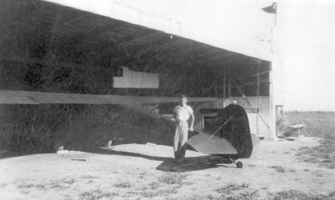
A 1940 photo of G.J. Smith facing west standing in front of a Hampton Field field with the Taylorcraft in which he had just soloed (courtesy of Terry Smith).
The date of construction of this small general aviation airfield on the southwest side of Dallas has not been determined.
According to Terry Smith, “Hampton Field was located on the southeast corner of Illinois Avenue & Hampton Road.
It was a grass field with 1 metal hangar & was on the north end of Kiest Park in Oak Cliff.
My dad [G.J. Smith] soloed there in 1940 in a Taylorcraft.”

A 1940 photo by his flight instructor of G.J. Smith's 1st solo takeoff in a Taylorcraft from the grass at Hampton Field (courtesy of Terry Smith).
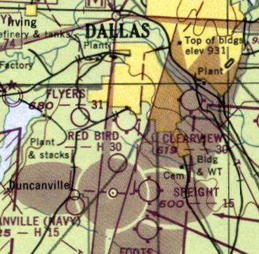
Hampton Field was not depicted on the August 1941 Dallas Sectional Chart.

Hampton Field was depicted on a 1942 map of Dallas NRAB Outlying Fields (courtesy of John Voss).

The earliest aeronautical chart depiction which has been located of Hampton Field was on the February 1943 Dallas Sectional Chart,
which depicted it as a commercial/municipal airport.

Hampton Field was depicted on a 1940s Love Field approach plate (courtesy of Terry Smith).
Hampton Field was still depicted on the March 1944 Dallas Sectional Chart.

Hampton Field was depicted simply as a square outline labeled “Airport” on a 1945 Dallas map.

Hampton Field was evidently renamed Clearview at some point in 1945,
as that is how it was labeled on the September 1945 Dallas Sectional Chart.

An undated (late 1940s?) aerial view of Clearview Airport (courtest of Jerry Felts)
depicted it as having one unpaved runway running diagonally within a square property outline,
with several light aircraft parked near some small buildings on one corner.
The last aeronautical chart depiction which has been located of Clearview Airport was on the September 1948 Dallas Sectional Chart,
which depicted Clearview as having a 3,000' unpaved runway.
Clearview Airport was evidently closed at some point between 1948-49,
as it was no longer depicted on the August 1949 Dallas Sectional Chart.
According to Terry Smith, “The hangar was torn down & houses were built on the property shortly after WW2.”
A 2013 aerial photo showed no trace remaining of Hampton Field.
According to Terry Smith, “The location of the hangar at Hampton Field was in the parking lot of the current shopping center in the 2013 photo.”
Thanks to Terry Smith for pointing out this field.
____________________________________________________
32.853, -96.963 (West of Dallas, TX)

1/4/53 USGS aerial view of Jap Lee Airport.
Jap Lee Airport was not yet depicted on the August 1941 Dallas Sectional Chart.
According to the Irving Independent School District, in 1942 American Airlines Captain Thomas Jasper Lee
“moved to Irving on 48 acres he purchased for $3,000. The land had a house, barn, and pasture land.
It was probably the fulfillment of a lifelong dream when Captain & Mrs. Lee opened the Jap Lee Airport.”
According to the City of Irving, “Thomas Jasper Lee, an airline pilot stationed at Love Field in Dallas, built the field on his property in Irving in 1947.”
According to the Irving Independent School District, “The terrain was suitable for an airstrip & they leased an additional 66 acres to accommodate 14-16 small private airplanes.
Tie-down space cost $6, and hangar rental was $10 monthly.
A windsock flew over the barn, and pasture land served as a landing strip.
Because there were no phone lines in this rural area, Captain Lee cut saplings to run a line from Highway 183 to his land.
Captain Lee's job was flying, his hobby was flying, and the family business was operating an airport.
He liked to take his wife & daughter on trips in his club coupe or fly older aircraft for the fun of it.
He stayed busy helping other pilots work on their planes.
Children who rode their bicycles to the airport could be assured of a warm welcome & help with any bicycle repairs they needed.”
The earliest photo which has been located of Jap Lee Airport was a 1/4/53 USGS aerial view.
It depicted the field as having a single unpaved north/south runway, with a few small buildings on the east side.

A 1954 plan (courtesy of Reginald Robinson) depicted Jap Lee Airport as having a 3,800' Runway 17/35, with an office & 2 small hangars on the southeast side.
Reginald Robinson recalled, “I was a neighbor to Jean Lee, the widow of Jap Lee.”

showed one single-engine light plane next to a Quonset hut at Jap Lee Airport.
According to the Irving Independent School District, “Captain Lee was still a pilot for American Airlines when he died on 12/6/55.
It was after his death that the family sold the land to the Irving ISD for the construction of the school named for T. J. Lee.”

Jap Lee Airport, as depicted on a 1957 road map (courtesy of James Buchanan).
The last photo which has been located of Jap Lee Airport was a 1958 aerial view.
It depicted the field as having a single unpaved norths/south runway, with 5 small hangars on the east side,
near which were parked 3 light aircraft.
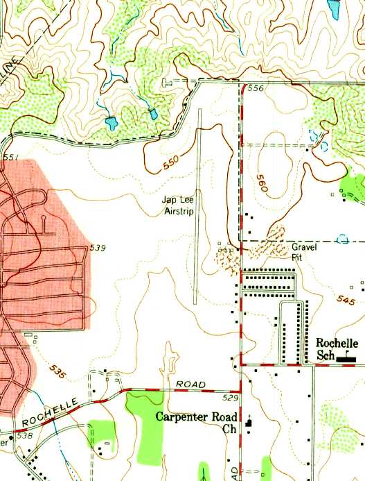
The last depiction which has been located showing Jap Lee Airport operational was on the 1959 USGS topo map.
It depicted “Jap Lee Airstrip” as having a single north/south runway, with a few small buildings on the east side.
According to the Irving Independent School District, “T.J. Lee Elementary School opened in March of 1959”,
at which point the airport on the property had presumably been closed.
However that date is contradicted by the City of Irving, which says “His wife continued operating the airport until 1960.”

A 9/1/60 Civil Aeronautics Administration document (courtesy of Jean Lee, widow of Jap, via R.E. Robinson)
said Jap Lee Airport “Will be ABANDONED as of 9/1/60 per memo 7/20/60.”
It depicted the airport as having 3 turf runways, with a longer proposed 4th runway.
R.E. Robinson reported, “Our Irving homes are only a few blocks from the original site of the airport.
Mrs. Lee & I moved here in 1963 when the area was a new development.”
A 1972 aerial photo showed that houses & a school had covered the site of Jap Lee Airport,
erasing any trace of the little airport.

A 6/13/11 aerial photo of the site of Jap Lee Airport showed that houses & a school had covered the site of Jap Lee Airport.
According to the Irving Independent School District, “The present-day boundaries [of Jap Lee Airport] are Coker Street, Janelle Street, Stafford, and Northgate Drive.”
____________________________________________________
Dalworth Airport / Curtiss-Wright Airport /
Grand Prairie Municipal Airport / Grand Prairie NOLF /
Grand Prairie Army Airfield, Grand Prairie, TX
32.734, -97.02 (West of NAS Dallas, TX)

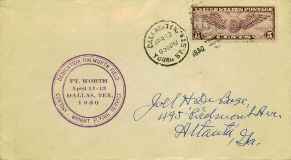
A postmark commemorated the 4/11/30 Dedication of Dalworth Field, Curtiss-Wright Flying Service.
This historic property has been an airfield with at least 6 different names,
having gone from a civil airport, to a military airfield, back to a civil airport, and finally as a housing development!
As described by The Handbook of TX Online,
the Curtiss-Wright Airport of Fort Worth-Dallas was built to the west of Grand Prairie in 1929.
It was one of a large number of civil airports built & operated
by the Curtiss-Wright company across the country during the 1920/30s.
The Curtiss Flying Service Corporation operated a flight school at the Grand Prairie field.
According to a TX Historical Commission sign, “The Curtiss Flying Service Corporation of NY
purchased 275 acres of land one mile west of the Grand Prairie city limits in 1929.
The Curtiss Wright Airport of Fort Worth-Dallas was opened on this site in 1930.”
A postmark commemorated the 4/11/30 Dedication of Dalworth Field, Curtiss-Wright Flying Service.
According to a TX Historical Commission sign, “Though the airport & flying school were a sensation, they closed late in 1930 due to the Depression
and the field became the Grand Prairie Municipal Airport.”

The earliest aeronautical chart depiction which has been located of the field
was on the 1932 Dallas Sectional Chart (courtesy of Scott O'Donnell).
It depicted “Curtiss-Wright” as a commercial/municipal airport.
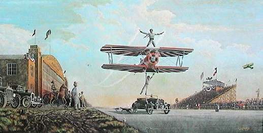
A 1983 painting by Randy Souders of an undated airshow at the Grand Prairie Curtiss-Wright Airport.
After the Curtiss flight school went out of business,
the field served as the Grand Prairie Municipal Airport until 1940.
In 1940 it was purchased by the Lou Foote Flying School,
which operated a contract flying school for military flight cadets.
"Grand Prairie" was still depicted as a commercial airport
on the February & September 1942 Dallas Sectional Charts (courtesy of Chris Kennedy).

"Grand Prairie Squadron 2", as depicted on a 1942 Navy map of Dallas Outlying Fields (courtesy of John Voss).
In 1942, the Navy faced a need to establish a new primary flight training field in the area,
as the Army (which controlled Hensley Field, later to become NAS Dallas, 2 miles east)
forbade solo flights by Navy flight cadets at the busy Hensley Field.
Therefore, the Navy entered into negotiations to purchase the Lou Foote Flying School property.
An agreement could not be reached, so the property was condemned in 1942,
and the Grand Prairie Naval Outlying Landing Field was established.
Grand Prairie was also known as Squadron Two.
According to a TX Historical Commission sign, “The naval development cost was approximately $823,000
which included two 1,500' hexagon landing mats, 2 personnel barracks, a hangar, new maintenance and operations buildings, roadways, sidewalks and utilities.
About 1,000 men trained on this site during World War II, some flying at night without permanent landing lights.
The field was regarded as an excellent training ground for its capabilities.”

A 1943 National Archives photo of the Grand Prairie NOLF.
By 1943, all Navy primary flight training at Hensley has relocated to Grand Prairie,
and a contingent of French cadets began flight training as well.
By the end of 1943, a total of 280 Stearman biplane trainers were on board at Grand Prairie.
The August 1944 Dallas Sectional Chart (courtesy of David Brooks)
depicted the airfield as Outlying Field "26803", as an auxiliary of Hensley Field.
According to a TX Historical Commission sign, “At the close of World War II, the Navy discontinued its training operations at the Grand Prairie site,
using it instead as an emergency landing field.”
After end of WW2, Grand Prairie was used temporarily to store surplus aircraft.
In 1945, it had almost 300 SNV trainers awaiting disposal.
Alden Gaw recalled, “We lived in the Indian Hills subdivision adjacent to the east side of the airport property from 1945-62.
My father, Ernest Gaw, kept his Vultee BT-13 at the Grand Prairie Airport from 1946-51.
He used the BT as a means to cover his territory as a field service sound engineer
and was paid mileage by the company he worked for.
He would buzz our house in his 'Vultee Vibrator' on his return home as the signal for us to come pick him up at the airport.
One time I recall our mother allowing us 3 kids to run from our house a half-block from the field on the east side of the airport,
across the field to greet him at his tie-down, while she drove the car the street route there.
We got no more than 50 yards into the field before our adventure came to an abrupt halt.
Our bare feet were 'attacked' by the thorny stickers that blanketed the former pasture
and our mother, seeing us stranded & crying in the field, had to drive the car into the field to rescue us.”
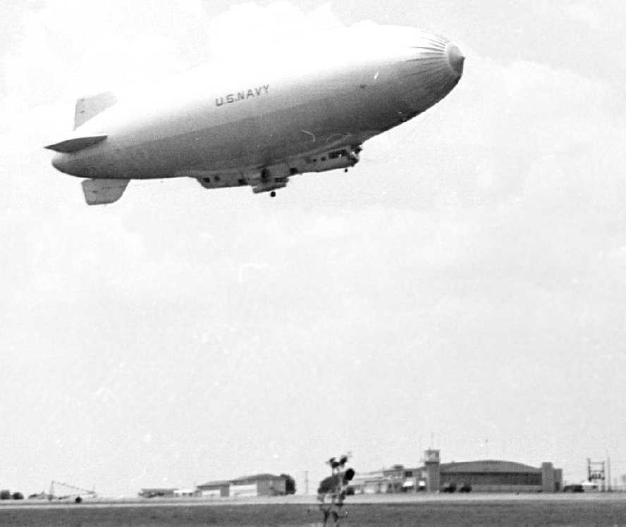
A circa 1946-47 photo (courtesy of Ernest Gaw family) of a Goodyear M-type airship, over the Grand Prairie hangars.
According to Alden Gaw, “Around 1946-47 the Grand Prairie NOLF briefly hosted non-rigid blimp operations.”
Both K-type & M-type airships were photographed at Grand Prairie.
Of the M-type airship, Alden noted, “There were only 4 built, M-1 through M-4.
No marking other than US Navy are evident, but the articulating control car makes this on an unmistakable 'M' model.
The M’s were used in long-range operations testing between a number of New Mexico & Texas bases.”
"Grand Prairie" was still depicted as a Navy airfield
on the March 1947 Dallas Sectional Chart (courtesy of Chris Kennedy).
A circa 1947-48 aerial view looking northeast (courtesy of Ernest Gaw family), taken from Ernest's Vultee BT-13.
Alden Gaw observed, “The main hangar can be seen in the middle, left of the picture just south of Highway 80 or Jefferson Blvd.
The Indian Hills subdivision, built during the war, almost touches the east most hexagon apex.
This was before Carrier Parkway ran north-south between the subdivision & the airport property.”
Alden Gaw recalled, “My brother & I used to scurry all over the airport as kids on our bikes,
watching countless aircraft, helicopter, glider and parachutist operations,
as well as watching maintenance be performed in the hangars over the years.
I recall one summer a parachutist landed in the power lines on the north side of Jefferson
and remained suspended for a time until rescued.
Eventually open T-hangars were erected over the southwest tie-down pads
and many gliders were kept in these T-hangars.
The north-south runway was far from level.
It dropped off precipitously just south of the mid-field taxiway.
The southern hexagon pad was at least 15-20' lower than the north end of the field.
I vividly recall watching aircraft on their takeoff rolls to the south disappear down the hump
and then reappear on climb-out & watching them land to the south,
touch down then disappear as they rolled down the incline & reappear at the far end of the runway as they turned around to taxi back.
When they taxied from the south end of the runway northward
it seemed like forever before they reappeared as the rose up over the incline.”

A circa 1948-49 photo of Ernest Gaw in front of his Vultee BT-13 (courtesy of Ernest Gaw family),
looking northeast with the Grand Prairie hangar in the background.
The lettering on the hangar read “North Texas Agricultural College, School of Aeronautics, Grand Prairie Airport”.

A circa 1948-49 photo (courtesy of Ernest Gaw family)
of a Bowlus Baby Albatross glider being pushed in front of the Grand Prairie hangar / control tower.
The glider was possibly part of the School of Aeronautics program.
Lee recalled, “In 1948 I was at Carswell in the B-36 program at that time
and placed on TDY to Grand Prairie to obtain my A&P rating.
There was considerable glider operation there at that time.”
John Price recalled, “Texas Soaring Association was based here from 1949-65.
Much of this video documentary was shot at the old airport in 1954.”
Frank Strickler recalled, “The Curtis/Navy/TX AANG/civil field east of Grand Prairie...
I flew in & out of the field at the same time the Guard had L-19s in the hangar.
I don't recall any civil hangars but long rows of tie-downs.
I think James Almand kept his Mustang in the old hangar before the Guard got it.”
According to a TX Historical Commission sign, “In 1953 the Navy authorized the Department of the Army
to use the installation for the Air Section (later the 149th Aviation Battalion) of the 49th Armored Division of the TX National Guard.”
A circa 1954 Navy map of Ft. Worth area Navy airfields (National Archives, courtesy of Ron Plante) depicted Grand Prairie as “OF 26803”.
Alden Gaw related, “I also recall the 49th Texas Air National Guard unit operating out of the airport throughout the mid-1950s & 1960s.”
Dallas resident Jerry Felts recalled,
"As a child, our family used to pass by once a month or so on Highway 80 on our way to Ft. Worth to visit relatives.
I always thought the activity there to be a letdown after just passing by Navy Dallas
and seeing all those amazing aircraft taking off & landing there.
I remember seeing my first parachute jump there in the late 1950s as it was the home, at that time,
of the Dallas Parachute Association.
Also, there was a glider operation there at the time.
I don't know how all that fit in with the ANG operation
but seems that at the time it was dormant as to military use."

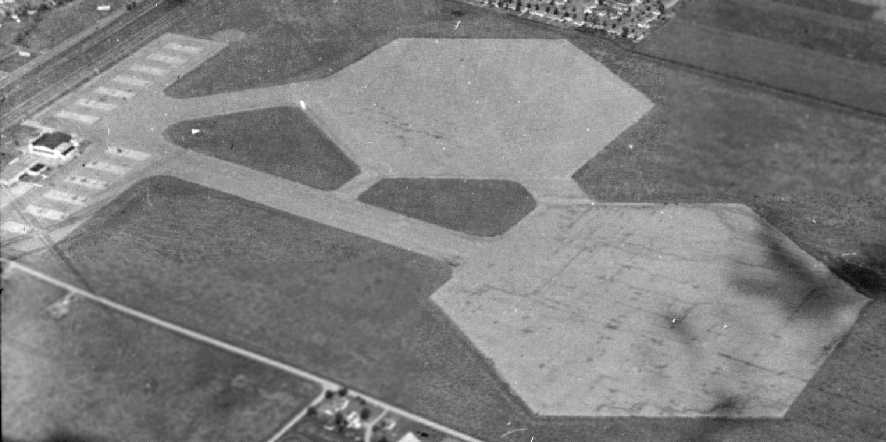
A 1958 aerial view depicted Grand Prairie still largely in its WW2 configuration, with the 2 hexagonal landing mats.
But by this time the field had been reused as a general aviation airport.

A closeup from the 1958 aerial photo depicted 2-dozen general aviation aircraft parked on Grand Prairie's northwest ramp.
A row of T-hangars had been added on the south side of the ramp for small general aviation aircraft.
By 1959 the Navy had evidently vacated the field & it became once again the Grand Prairie Airport,
as that is how it was labeled on the 1959 USGS topo map.

The status of the Grand Prairie airfield was not clear by 1960,
as it was listed as "Grand Prairie (AFA)" in the 1960 Jeppesen Airway Manual (courtesy of Chris Kennedy).
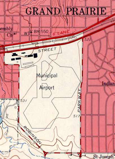
It was depicted as having a single 2,800' paved Runway 17/35,
in addition to the two 1,500' hexagonal landing mats.
A ramp was depicted on the northwest side of the field, with multiple buildings.
According to a TX Historical Commission sign, “In 1962 the Army authorized the City of Grand Prairie to use 195 acres as a public airport.”

The 1963 TX Airport Directory (courtesy of Steve Cruse)
depicted the "Grand Prairie Airport" as having a total of 3 asphalt runways
(2,900' Runway 17/35, 3,000' Runway 2/20, and 1,800' Runway 11/29)
which were superimposed on the 2 former Navy hexagonal landing mats.
The southeast portion of the northeastern asphalt hexagonal former landing mat
was designated as a general aviation tie-down area.
A paved ramp on the north side of the runways had a Civil Air Patrol hangar & a National Guard hangar.
The manager was listed as E.E. Longbrake.
According to a TX Historical Commission sign, “The city sold 127 acres in 1964 & built a larger airport south of this site”,
4 miles to the southwest, on the site of the former Tower NOLF.
Apparently the original Grand Prairie Airport site was constrained geographically,
and the runway could not be lengthened to accommodate jets.
Jerry Felts recalled, "In the late 1960s there was some military helicopter activity at the facility
but the equipment (CH-37 Mojave) seemed obsolete compared to the state of the art for the time.
I spent a weekend at the AANG facility while in the Sea Scouts in 1962
and there was still a military chow hall & other administration offices operational at the time
along with some light observation type aircraft that were parked on the asphalt ramp by the hangar."

The July 1968 DFW Sectional Chart (courtesy of Chris Kennedy)
depicted both the "Grand Prairie AAF" along with the new "Grand Prairie" Municipal Airport to the southwest.
Sam Swinnea recalled, “The old Grand Prairie Airport with the 2 hexagonal pads...
I grew up about 2 blocks away from there, to the north, and I remember during the late 1960s there was a National Guard base there.
There were only helicopters & some trucks there due to the city airport being moved to the south & built new from the ground up.
The old airport could not be expanded due to a drop off to the south.
The National Guard base was totally open & anyone could walk right up to the helicopters & look them over.
They were smaller ones but there must have been larger ones there as well since a paratrooper Guard unit depended on them to supply aircraft for their jumps.
The road that was built through the middle of the airport, the one that runs north to south, was the first part of Grand Prairie's 'Loop Nine' which was never built.
This road was to enclose Dallas County in the same way Loop Twelve does but the road never received any funding.
Grand Prairie was intent on pushing this road through & even secured the right of way which can be seen in the last photo.
Securing this right of way was easy since the city owned the land.
And since the city owned the land a few buildings were built on the west side of the property.
A police station, a library, and a US Post Office and then the land was developed for commercial uses.
There were warehouses built along the west side of the right of way & a bank building built upon the east side.
The road was expanded to 4 lanes with a wide median to lay claim to the entire right of way.”

Curiously, the 1968 USGS topo map still depicted the “Municipal” Airport with its 2 hexagonal landing pads, taxiways, and hangars,
but it also depicted that a new road had been built through the middle of the airfield.
A building had been built in the center of the northeastern landing pad, evidently a row of T-hangars for civilian aircraft.
A 9/18/68 USGS aerial photo showed 3 large helicopters (what appear to be Sikorsky CH-37 Mojave heavy-lift helicopters)
parked on Grand Prairie's northwest ramp.
A row of T-hangars had been built over the eastern hexagonal landing pad, and a dozen light planes were parked around it.
Alden Gaw recalled, “During the late 1960s & early 1970s
I noticed business developments encroached onto the eastern side of the airport,
first with a bank building & quickly followed by other commercial operations.”
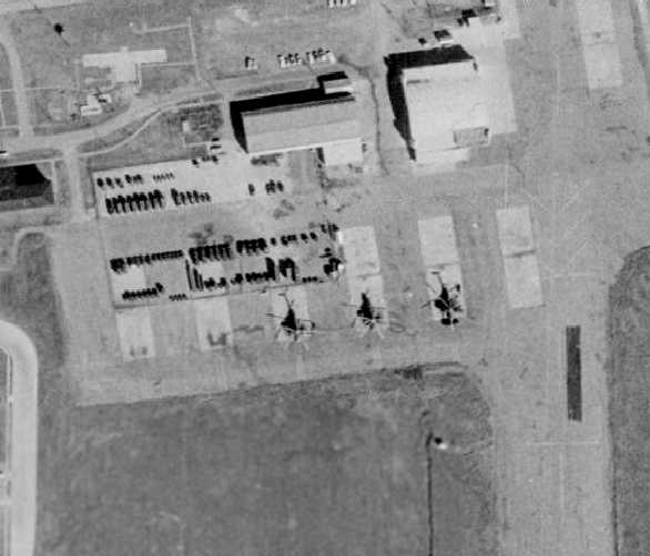
A closeup from the 1970 aerial photo depicted 3 large helicopters (what appear to be Sikorsky CH-37 Mojave heavy-lift helicopters)
parked on the ramp at Grand Prairie.
The row of T-hangars along the south side of the ramp had been removed at some point between 1958-70.
According to a TX Historical Commission sign, “The 19th Aviation Battalion remained until 1976, when the airfield was closed.”
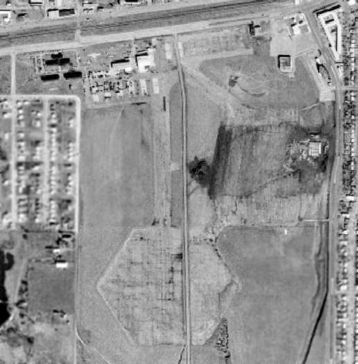
A 1972 aerial view still showed the hexagonal landing pads to be recognizable,
but it appeared as if the aviation use of the property had ended, with cars & other objects parked along the former ramp area.
The main hangar appeared to remain standing.
The 1973 USGS topo map no longer depicted the landing pads or any runways.
The former hangars at the northwest corner were still depicted, but some of them had been removed.
“Grand Prairie AANG”, as depicted on a 1973 DFW Terminal Control Area Chart (courtesy of Fred Fischer).
By the time of the 1978 DFW Sectional Chart (courtesy of Ray Brindle),
nothing at all was depicted at the site of the original Grand Prairie airfield.
On a 1979 aerial view, the hexagonal landing pads were no longer discernible at all.
The airport property was turned into an industrial park,
with 2 large buildings having been built on the west side of the property,
and there was no longer any recognizable trace of the former airfield.
On the 1981 USGS topo map, a 2nd road had been built through the former airfield.
In the 1995 USGS aerial photo, the majority of the Grand Prairie AANG site still consisted of an open grass field,
with no trace perceptible of the former asphalt landing mats.
Numerous buildings had been constructed along the west & north sides of the property.
In 1998 a TX Historical Commission sign was erected commemorating Grand Prairie Airfield.

A circa 2001 aerial photo of the site.
Jerry Felts said, "I was out there about a year ago to see if there were any remains of the runway
or anything else about the place but all I could find was a couple of concrete structures
that looked like bases for runway lighting."

Entrance sign to the new Curtiss-Wright Village.
As pointed out by Scott O'Donnell,
15 acres of what was formerly the Curtiss-Wright Airfield are being redeveloped in 2002 as Curtiss-Wright Village,
a community of 102 town homes.
Jerry Felts pointed out that "That place been totally developed since I was there last year [2001].
My compliments to the people who are building the Curtiss-Wright Development,
what a great way to honor a former aviation site.
All the streets are either famous aircraft names or named for famous aviators.”

A 6/8/11 photo of a 1998 TX Historical Commission sign commemorating Grand Prairie Airfield.
The site of the Curtiss-Wright Airport is located
southwest of the intersection of Jefferson Street & Carrier Parkway.
____________________________________________________
Tarrant Naval Outlying Landing Field / Arlington Naval Outlying Landing Field / OLF 25811,
Arlington, TX
32.688, -97.128 (Southwest of Dallas NAS, TX)

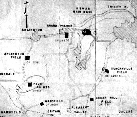
This field was labeled "Tarrant" on a 1942 Navy map of Dallas Outlying Fields (courtesy of John Voss).
This field was built during WW2 as one of 20 satellite fields used by Dallas NAS.
Arlington NOLF was evidently constructed at some point between 1941-42,
was it was not yet depicted on the August 1941 Dallas Sectional Chart.
The earliest reference to the field which has been located
is a 1942 map of Dallas NRAB Outlying Fields (courtesy of John Voss), which labeled it as "Tarrant".

A 1943 aerial view of Arlington NOLF (National Archives photo).
At the time of the above photo, the airfield consisted of a paved octagon landing surface,
along with a taxiway that led to a large rectangular paved ramp area.
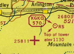
The August 1944 Dallas Sectional Chart (courtesy of David Brooks) depicted the field as Outlying Field "25811".
Arlington NOLF was still depicted as an active Navy airfield
on the March 1947 Dallas Sectional Charts (courtesy of Chris Kennedy).

Arlington was still depicted as a Navy airfield on the 1948 USAF Urban Area Chart.

"Arlington (Navy)" was depicted on the February 1949 Dallas Sectional Chart (courtesy of David Brooks)
as having a 1,300' hard surface runway.

The last photo which is available of Arlington NOLF was a 1/4/53 USGS aerial view,
which showed the field to remain completely intact, but with no sign of any aviation usage.
A circa 1954 Navy map of Ft. Worth area Navy airfields (National Archives, courtesy of Ron Plante) depicted “Arlington Field OF 25811”.
A 1957 aerial view showed that Arlington NOLF remained intact, though deteriorated.
Arlington NOLF was not depicted at all on the 1959 USGS topo map or a 1960 Humble Oil DFW road map.
The pavement of Arlington NOLF was evidently removed at some point between 1957-63,
as a 1963 aerial view showed that the outline of the airfield was still recognizable, although the pavement had been removed.
The 1964 DFW Sectional Chart (courtesy of Ross Richardson) did not depict anything at all at the site of Arlington NOLF.
A 1970 aerial view showed that the airfield outline of Arlington NOLF was still barely recognizable.
A 1979 aerial view showed that houses had covered the site of Arlington NOLF at some point between 1970-79.

As can be seen in the circa 2001 aerial photo,
the area is now heavily developed, and not a trace of the Arlington airfield remains.
The site of the Arlington NOLF is located northeast of the intersection
of South Cooper Street & West Arbrook Boulevard.
Arlington NOLF is not to be confused with the Arlington Municipal Airport,
which was built at a later date on a different site a few miles to the southeast.
Thanks to Ed Jerue for determining the location of this field.
____________________________________________________
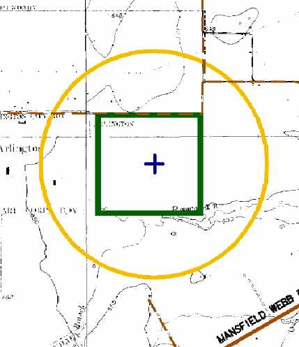
Mansfield Naval Outlying Landing Field / OLF 22614, Mansfield, TX
32.575, -97.092 (Southwest of Dallas NAS, TX)
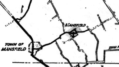
The location of Mansfield NOLF, as depicted on a 1942 Navy map of Dallas Outlying Fields (courtesy of John Voss).
This field was built during WW2 as one of 20 satellite fields used by Dallas NAS.
Mansfield NOLF was evidently constructed at some point between 1941-42,
was it was not yet depicted on the August 1941 Dallas Sectional Chart.
The earliest reference to the field which has been located
is a 1942 map of Dallas NRAB Outlying Fields (courtesy of John Voss).

At the time of a 1943 aerial view (National Archives photo), the airfield consisted of no less than 8 paved runways,
arranged evenly around the compass.
This arrangement removed any need to ever have to land in a crosswind,
which was desirable for beginning flight students.
Beachwalker recalled, “The Mansfield Airport... I lived not a mile from the Airport
and can remember the Navy training planes coming over the house
and my grandfather saying that one is going to crash but none that I remember ever did.
There were barracks & Quonset Huts.
I can also remember them clearing land for the runway etc.
The runway was pointed south from Fruit Street and the planes went over the Norton Reservoir in taking off.
There was in addition to the barracks, one of those obstacle courses, I guess for training or for keeping the pilots in condition.”
Mansfield NOLF was still depicted as an active Navy airfield
on the March 1947 Dallas Sectional Chart (courtesy of Chris Kennedy).
The date of closure of Mansfield is unknown.
It was most likely closed immediately after the end of WW2.

Mansfield was still depicted as an active Navy airfield on the 1948 USAF Urban Area Chart,
but it may have been abandoned by that point.
A circa 1954 Navy map of Ft. Worth area Navy airfields (National Archives, courtesy of Ron Plante) depicted “Mansfield OF 21614”.
The Mansfield airfield was no longer depicted at all on the 1959 USGS topo map,
the 1960 Humble Oil DFW road map,
or the 1964 DFW Sectional Chart (courtesy of Ross Richardson).
According to Brian Rehwinkel, “Mansfield OLF’s asphalt was used for road paving in the area.”
In a 1970 aerial view, the outside perimeter of the former airfield remained recognizable,
but not even a trace remained of the former arrangement of 8 paved runways.

As can be seen in the 1995 USGS aerial photo of the site of Mansfield NOLF,
the overall shape of the former airfield remains recognizable
(note the similarity to the airfield outline as depicted in the 1948 chart).
However, not a trace remains (not even a "scar" in the grass)
of the former arrangement of eight paved runways.
According to Micheal Ritter, “They started construction in 2002” of “the new Mansfield High School” on the south side of the property,
as seen in a 2003 aerial photo of the site of Mansfield NOLF (courtesy of David Brooks).
The site of Mansfield NOLF is located southeast of the intersection of North Miller Road & Cannon Drive.
Thanks to David Brooks for determining the location of this field.
____________________________________________________
Five-Points Field / Naval Outlying Landing Field 22913 / , Watsonville, TX
32.624, -97.122 (Southwest of Dallas NAS, TX)

This field was labeled "Baker-Mansfield" on a 1942 Navy map of Dallas Outlying Fields (courtesy of John Voss).
This field was built during WW2 as one of 20 satellite fields used by Dallas NAS.
It was also known as Field 22913,
the numbers indicating it was on compass heading 229 from the main field & 13 miles away.
Five-Points NOLF was evidently constructed at some point between 1941-42,
was it was not yet depicted on the August 1941 Dallas Sectional Chart.
The earliest depiction of the field which has been located
is a 1942 map of Dallas NRAB Outlying Fields (courtesy of John Voss), which labeled it as "Baker-Mansfield".

The earliest photo which has been located of Five-Points NOLF was a 1943 aerial view (National Archives photo).
The airfield consisted of four 1,500' paved runways.

A June 1944 Navy layout (National Archives, courtesy of Ron Plante) described “Five Points Field” as a 162 acre property having 4 runways.
Five-Points NOLF was still depicted as an active Navy airfield
on the March 1947 Dallas Sectional Chart (courtesy of Chris Kennedy).
The date of closure of Five-Points is unknown.
It was most likely closed immediately after the end of WW2.
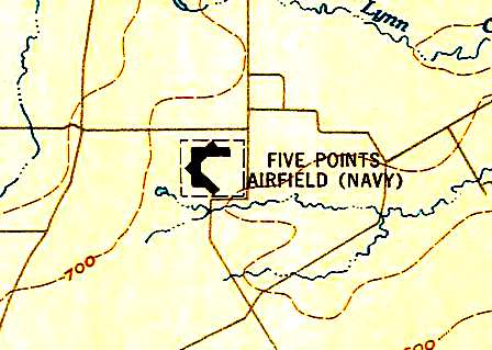
"Five Points Airfield (Navy)" was still depicted as an active airfield on the 1948 USAF Urban Area Chart,
but that may have been an oversight.

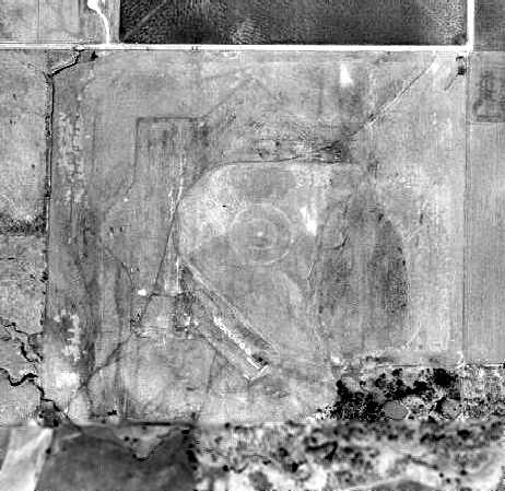
A 1/4/53 USGS aerial view showed the 4 runways of the former Five-Points airfield,
as well as the bomb target bull's-eye which had been built just east of the runways.
A circa 1954 Navy map of Ft. Worth area Navy airfields (National Archives, courtesy of Ron Plante) depicted “Five Points OF 22913”.
Five-Points NOLF was not depicted at all on the 1959 USGS topo map or a 1960 Humble Oil DFW road map.
The 1964 DFW Sectional Chart (courtesy of Ross Richardson)
did not depict anything at all at the site of Five-Points NOLF.
A 1970 aerial view showed the 4 runways of the former Five-Points airfield,
as well as the bomb target bull's-eye which had been built just east of the runways.
A 1990 aerial photo showed that trailers had been situated over the eastern half of the airfield,
but the distinctive shape of the landing field was still discernible on the western half.

In the 1995 USGS aerial photo,
the distinctive shape of the landing field was still discernible on the western half,
but the eastern half of the field was covered with a trailer park.
According to a site visit conducted by Scott Murdock,
by 2001 the western half of the field had been partly covered with new homes,
and the rest had been recently graded & work begun on utilities & roads.
During construction of the housing development on the site, 2 miniature practice bombs were found.
A 2003 aerial photo of the site of Five-Points NOLF (courtesy of David Brooks)
showed that the entire property had been covered by new homes,
with all traces of the former airfield now gone.
A 2001 Army Corps of Engineers diagram of the WW2-era boundaries of the Five Points airfield (green)
and its former bombing range (yellow).
The site of the airfield is located southwest of the intersection of Harris Road & Matlock Road.
____________________________________________________
Since this site was first put on the web in 1999, its popularity has grown tremendously.
That has caused it to often exceed bandwidth limitations
set by the company which I pay to host it on the web.
If the total quantity of material on this site is to continue to grow,
it will require ever-increasing funding to pay its expenses.
Therefore, I request financial contributions from site visitors,
to help defray the increasing costs of the site
and ensure that it continues to be available & to grow.
What would you pay for a good aviation magazine, or a good aviation book?
Please consider a donation of an equivalent amount, at the least.
This site is not supported by commercial advertising –
it is purely supported by donations.
If you enjoy the site, and would like to make a financial contribution,
you
may use a credit card via
![]() ,
using one of 2 methods:
,
using one of 2 methods:
To make a one-time donation of an amount of your choice:
Or you can sign up for a $10 monthly subscription to help support the site on an ongoing basis:
Or if you prefer to contact me directly concerning a contribution (for a mailing address to send a check),
please contact me at: paulandterryfreeman@gmail.com
If you enjoy this web site, please support it with a financial contribution.
please contact me at: paulandterryfreeman@gmail.com
If you enjoy this web site, please support it with a financial contribution.
____________________________________________________
This site covers airfields in all 50 states.