Abandoned & Little-Known Airfields:
Texas, Southeastern Fort Worth Area
© 2002, © 2016 by Paul Freeman. Revised 8/14/16.
This site covers airfields in all 50 states: Click here for the site's main menu.
____________________________________________________
Please consider a financial contribution to support the continued growth & operation of this site.
Midwest Airport (revised 8/14/16) - Oak Grove Airport (revised 8/14/16) - Pylon Field (revised 8/14/16) - Sky Ranch Field / Lucas Field (revised 8/14/16)
____________________________________________________
32.711, -97.252 (Southeast of Fort Worth, TX)
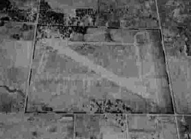
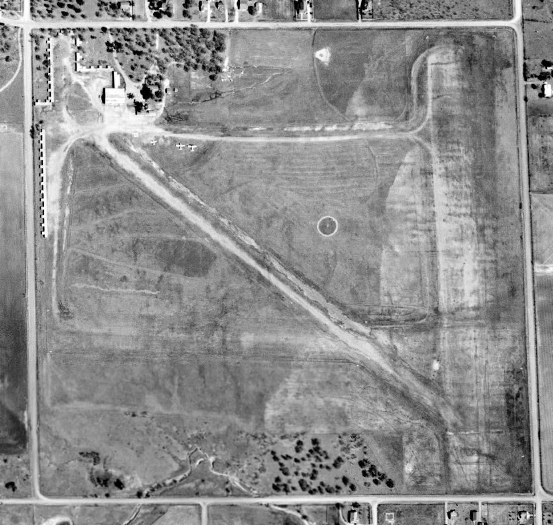
A 10/15/43 aerial view looking north at Midwest Airport
from the 1945 AAF Airfield Directory (courtesy of Scott Murdock).
The date of establishment of this small general aviation airfield has not been determined.
The earliest depiction which has been located of Midwest Airport
was a 10/15/43 aerial view looking north from the 1945 AAF Airfield Directory (courtesy of Scott Murdock).
It depicted Midwest as having 3 unpaved runways.
The directory described Midwest Airport as a 120 acre property
within which were 3 dirt runways, the longest being the 2,050' east/west strip.
The field was said to have 3 hangars, the largest being a 90' x45' metal structure.
Midwest was said to be owned & operated by private interests.
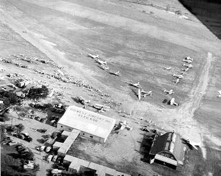
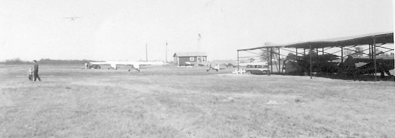
A 1945 aerial view looking south at Midwest Airport (courtesy of Jerrell Baley),
showing a hangar & barn (both of which had “Midwest Airport” painted on their roofs),
along with 2 grass runways & 21 light aircraft (including at least one glider).
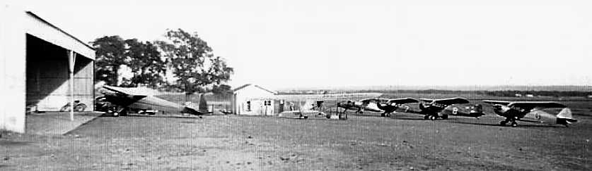
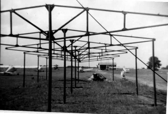
A circa 1940s photo of 7 taildraggers at Midwest Airport (courtesy of Gary Bradfield).
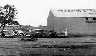
A circa 1940s photo of a hangar at Midwest Airport (courtesy of Gary Bradfield).
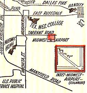
A circa 1940s map of the location & layout of Midwest Airport (courtesy of Tom Williams),
which depicted Midwest Airport as having 3 runways, oriented north/south, east/west, and southeast/northwest,
with several buildings on the northwest corner of the field.
Tom Williams recalled, “I took my first airplane ride at this Airport on January 3, 1946. I was 14 days old.
C. O. Williams [Midwest's Chief Flight Instructor] was my Dad.”
The earliest depiction which has been located of Midwest Airport were 2 circa-1940s photos,
showing several taildraggers next to a hangar.
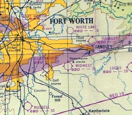
The January 1948 DFW Local Aeronautical Chart (courtesy of John Price)
depicted Midwest Airfield as having a 2,600' unpaved runway.
The 1948 USAF Target Complex Chart (courtesy of David Brooks)
depicted “Midwest Airfield” as having 3 runways & several taxiways.
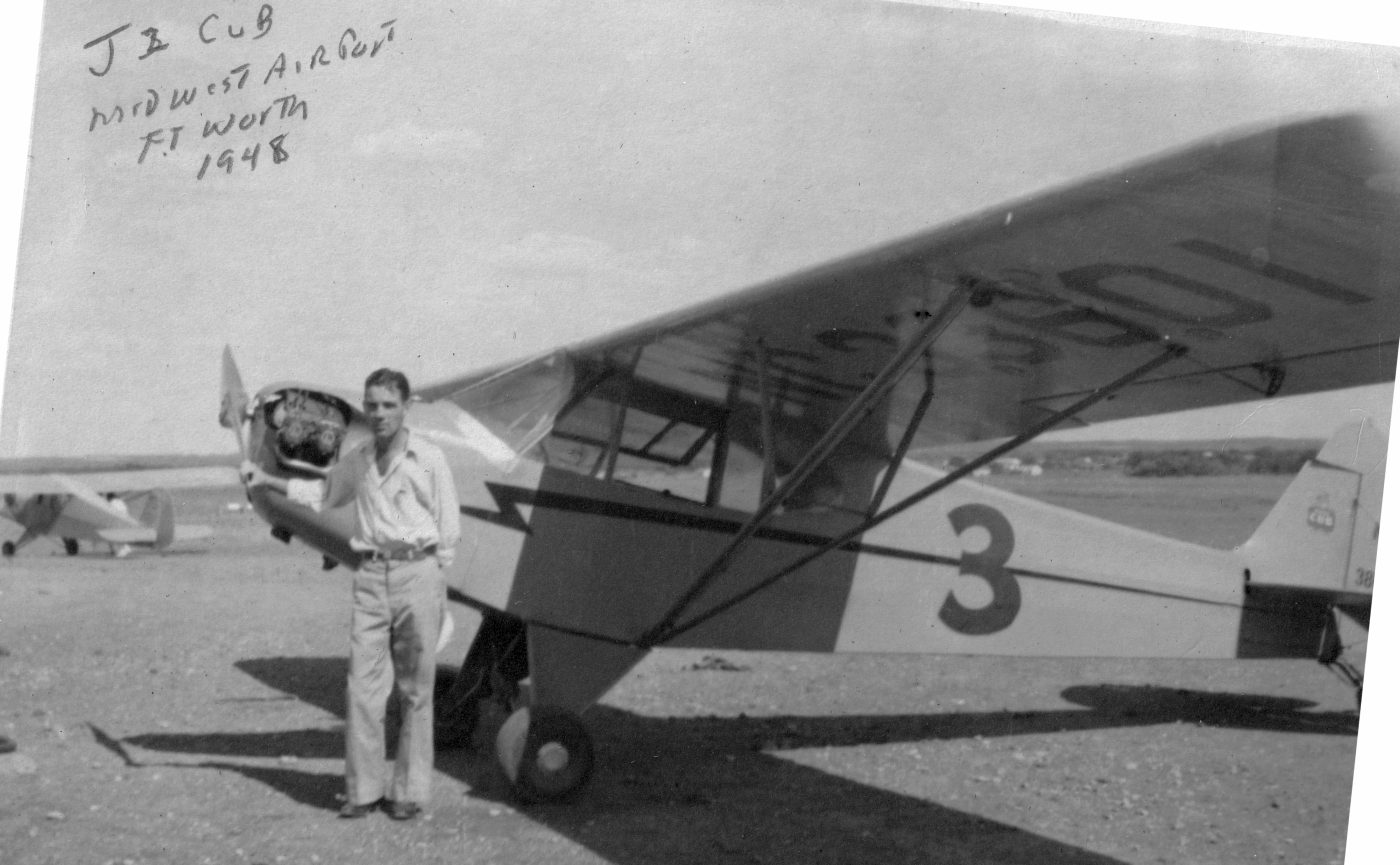
A 1948 photo of John Miller (when he was obtaining his private pilots license) in front of a Piper J2 Cub at Midwest Airport (courtesy of Mel Miller).
According to Tom Williams, Midwest Airport's Chief Flight Instructor C.O. Williams “moved to the TCU Airport [in] 1951.”
The last photo which has been located of Midwest Airport was a 4/1/52 USGS aerial view.
It depicted Midwest Airport as having several unpaved runways,
with 3 single-engine aircraft parked near a hangar & dozens of T-hangars on the northwest corner.
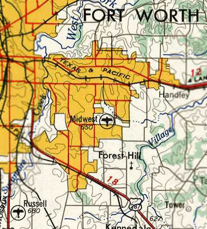
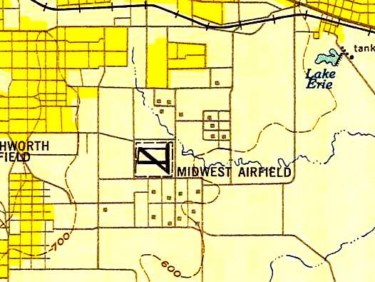
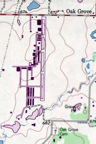
The 1954 USGS topo map depicted Midwest Airport.
Ganey Bradfield recalled, “Midwest Airport... I flew from it several times (I got checked out in the Civil Air Patrol's L-5) in the mid-1950s.”
Maurice Lambert recalled of Midwest Airport, “I flew in & out of there when I was a Civil Air Patrol Cadet in the 1950s.”
Ron Wortham recalled, “I was a kid of 12 in 1955 & I had a buddy who lived on Strong Street near what is now Berry Street in Poly.
We were just 3 blocks from a little airfield at what is now the intersection of Berry & Miller.
The airport featured an wind sock, a triangular wind direction indicator, a field shack
and old, junked AT-6 trainer that Barry & I used to go play in.”
Ron continued, “Finally one day a fellow named Hap (Foster, I believe) came out & chased us off.
He was nice about it but said the plane would be repaired.
This must have been near the end of the life of the airport - soon the AT-6 was gone.
Years later, Hap was one of my instructors at Russell Field.”
Gene Edwards recalled of Midwest Airport, “Lloyd Durham, James Rossing and I used to go there
and man the WWII salvage aircraft frames & pretend to be ace pilots.
I learned to emulate the sound of a machine gun & downed many an enemy aircraft.”
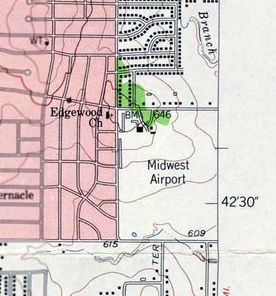
The last depiction which has been located of Midwest Airport was on the 1955 USGS topo map.
It depicted Midwest Airport as a rectangular open area without any specific runways,
with several small buildings along the northwest corner.
Midwest Airport was evidently closed (for reasons unknown) at some point between 1955-57,
as a 1957 aerial photo showed houses beginning to cover the former airport property.
The 1963 USGS topo map showed residential streets filling in the former airport property,
even though the map inexplicably continued to label the site as “Midwest Airport”.
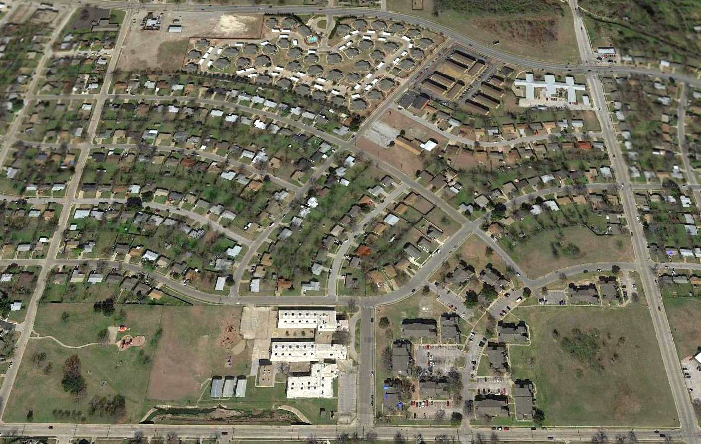
A 2016 aerial view looking north showed the site of Midwest Airport has been covered by houses, with not a trace remaining of the little airport.
The site of Midwest Airport is located southeast of the intersection of East Berry Street & South Edgewood Terrace.
____________________________________________________
32.704, -97.147 (Southeast of Fort Worth, TX)
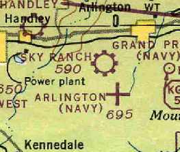
"Sky Ranch", as depicted on the March 1947 Dallas Sectional Chart (courtesy of Chris Kennedy).
This general aviation airfield was evidently established at some point between 1944-48,
as it was not listed among active airfields in the April 1944 US Army/Navy Directory of Airfields (courtesy of Ken Mercer).
The earliest depiction of an airfield at this site which has been located
was on the March 1947 Dallas Sectional Chart (courtesy of Chris Kennedy).
It depicted "Sky Ranch" as a municipal or commercial airfield.
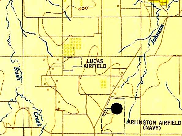
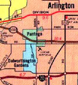
At some point within the next year, the field was apparently renamed "Lucas Airfield",
as that is how it was labeled on the 1948 USAF Target Complex Chart (courtesy of David Brooks).
It depicted the field as having an L-shaped outline,
but it did not depict any runways or buildings.
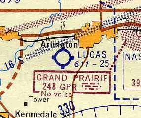
Lucas Field was depicted on the September 1957 Dallas Sectional Chart (courtesy of Chris Kennedy)
as having a 2,500' unpaved runway.
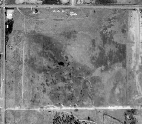
The earliest photo which has been located of Lucas Field was a 1957 aerial view,
which depicted Lucas as having 3 unpaved runways.
A total of 8 light aircraft were parked around a cluster of small hangars on the northwest side.
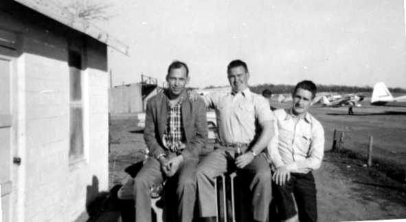
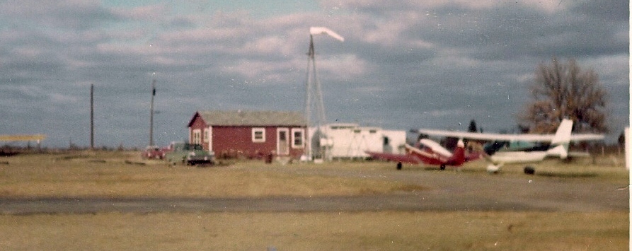
The earliest photo which is available of Lucas Field is a 1958 photo by Tom Russell (courtesy of Joel Russell)
of Dwayne Doss, James Harcrow, and Francis Claxton in front of the Lucas Field office building,
with several hangars & planes visible in the background.
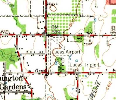
The 1959 USGS topo map depicted the Lucas Airport as having 3 unpaved runways.
Joel Russell recalled, “Pops' [Burnham's] shop was located west down Arkansas Lane
about a quarter mile or so from Lucas.
It was a magical place for a kid growing up,
with all kinds of planes in various stages of repair
and a bone yard out back that sheep kept mowed down.
The shop itself was a large metal Quonset hut & later a smaller concrete block building was off to the side.
He would rebuild all sorts of planes, then tow them to Lucas down Arkansas Lane
with the tail wheel tied over the tailgate of his turquoise Chevy Camino pick-up.”
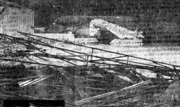
An early 1960s photo (courtesy of Joel Russell) of storm damage at Lucas Field, showing several inverted aircraft.
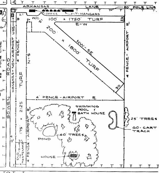
The 1963 TX Airport Directory (courtesy of Steve Cruse)
depicted Lucas Field as having 3 turf runways, with the longest being the 2,125' Runway 17/35.
Six hangars & an office were located along the northern edge of the field.
The manager of the field was listed as C.W. Burnum,
and the operator was listed as the Burnum Aviation Company, Inc.
The last photo which has been located showing Lucas Field in operation was a 1963 aerial view.
The airfield configuration was unchanged from the 1957 photo,
and there were 8 light aircraft visible on the field.
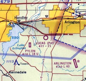
Lucas Field was depicted on the 1966 DFW Local Aeronautical Chart as a private airfield having a 2,100' unpaved runway.
Lucas Field was evidently closed (for reasons unknown) at some point between 1966-67.
as it was no longer depicted in the 1967 TX Airport Directory (courtesy of Brad Stanford).
According to Joel Russell, “Doc” said to his father (Tom Russell) of inventory of Lucas for sale:
“$30k gets ya 6 planes & some office equipment.”
David recalled, “Back in the late 1960's / early 1970's, as a child I played soccer in the Arlington Soccer Association.
All our games were played at 'Lucas Field', as were all league games for several years,
until the league grew too large and we needed new fields.
I can remember as a child that there was an old crashed airplane in a pond still there at Lucas,
and one building remained, which became a concession stand.”
Joel Russell recalled, “The wrecked plane at Lucas in the pond was an experimental 'Twin Luscombe'
that he [Pops Burnham] designed & built.
I don’t remember when, but what I do remember was that someone else flew it
and was involved in a ground loop accident & was written off. Pop never spoke of it.”
A 1970 aerial view still depicted several abandoned hangars on the northwest side of Lucas Field.
The airfield area was still intact, but no runways were discernible.
Lucas Airfield was still depicted on the 1979 AAA DFW road map,
but it had most likely been closed for several years by that point.
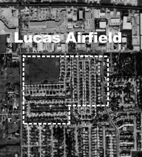
The location of Lucas Field, superimposed by David Brooks over the 1995 USGS aerial photo.
The site of Lucas Field has been covered by residential development,
and not a trace of the airfield appeared to remain.
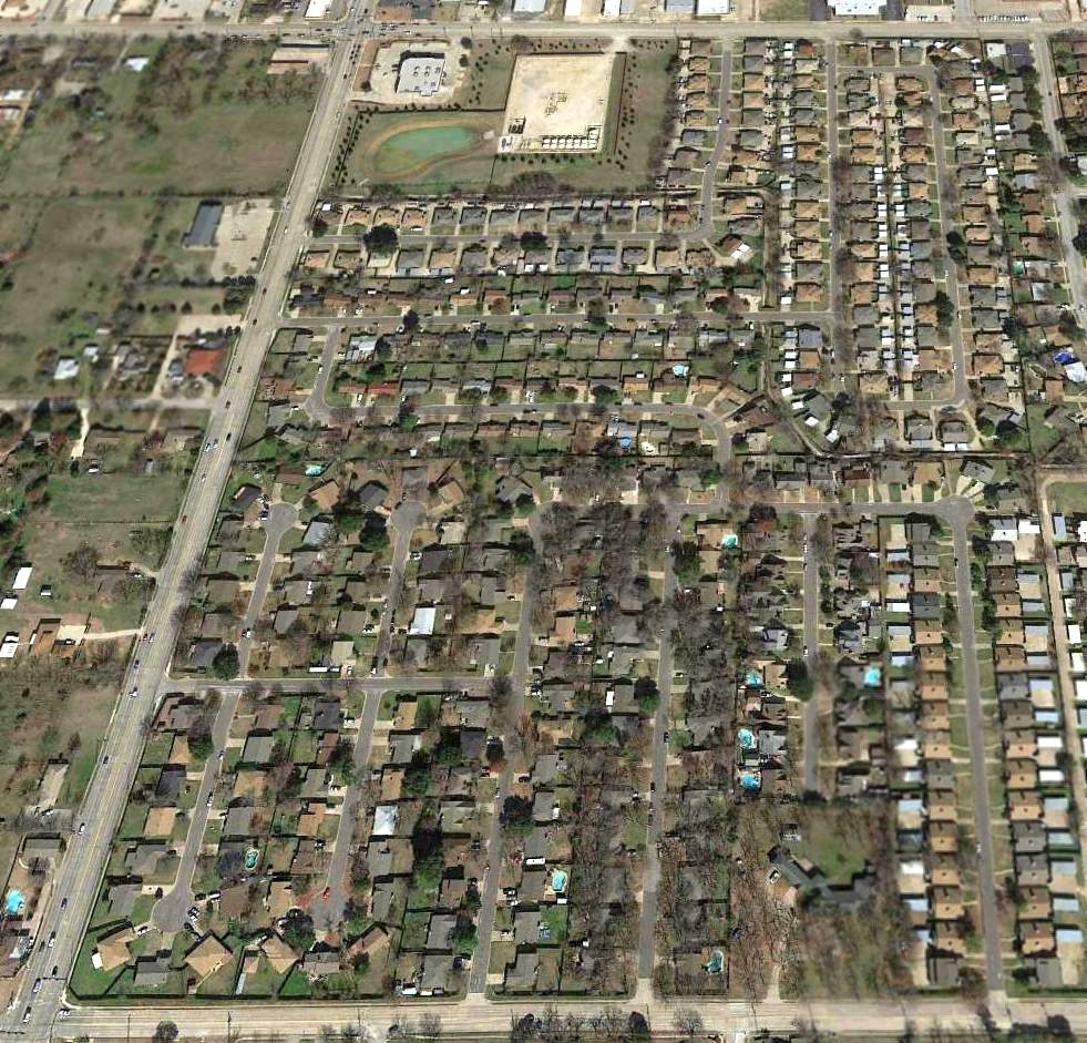
A 2016 aerial view looking north showed no trace remaining of Lucas Field.
The site of Lucas Field is located southeast of the intersection of South Bowen Road & Arkansas Lane.
____________________________________________________
Oak Grove Airport (F72), Oak Grove, TX
32.58, -97.3 (South of Fort Worth, TX)
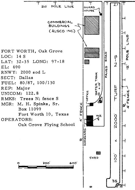
Oak Grove Airport, as depicted in the 1963 TX Airport Directory (courtesy of Steve Cruse).
Oak Grove Airport was built & operated by aviation pioneer Maurice Hunter "Pappy" Spinks.
He was a renowned aerobatic competitor & aviation manufacturer.
The devoted airman even lived in a house on the Oak Grove Airport property.
Spinks was a patron of the Aerobatic Club of America.
He was described by fellow aerobatic pilots as a "rough edged old millionaire",
who had made a fortune during the Vietnam War as a vendor for nearby Bell Helicopter,
by manufacturing the skids for their Huey helicopters.
The precise date of construction of Oak Grove is unknown.
It was apparently opened between 1962-63,
as it was not yet depicted at all on the 1958 USGS topo map,
nor listed among active airfields in the 1962 AOPA Airport Directory.
The earliest depiction of Oak Grove Airport which has been located
was in the 1963 TX Airport Directory (courtesy of Steve Cruse).
It depicted the field as consisting of a single 2,000' turf Runway 17/35.
The operator was listed as Oak Grove Flying School.
Two hangars & an office were shown west of the runway,
along with several large buildings along the north side labeled "Commercial Buildings (ALSCO Inc.)".
These were presumably the manufacturing facilities which produced the Huey helicopter skids.
Al Pugsley recalled, “I flew out of Oak Grove & was the chief instructor there for Pappy Spinks before I left in 1963.”
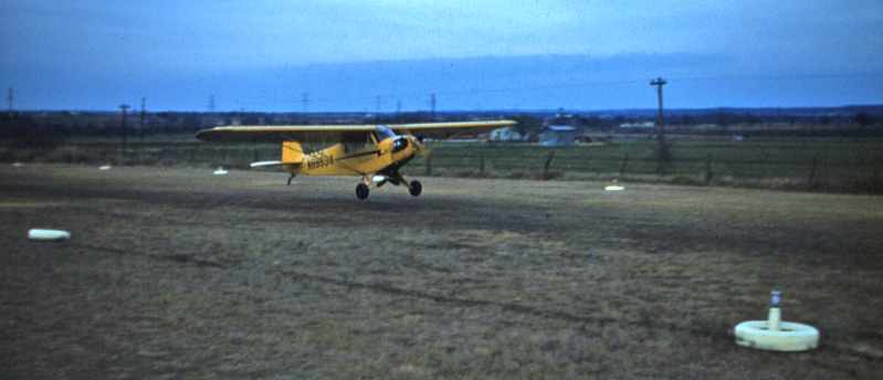
The earliest photo which has been located of Oak Grove Airport was a 1/1/63 photo by Ken Morris Sr.:
Ken Morris Jr. recalled, “I soloed off of Oak Grove Field on January 1, 1963 in one of Pappy Spinks' Piper J-3s.”
Note Oak Grove's dirt runway.
A 1963 aerial view depicted Oak Grove as having a single north/south unpaved runway,
with several hangars & 8 light aircraft on the west side of the field.
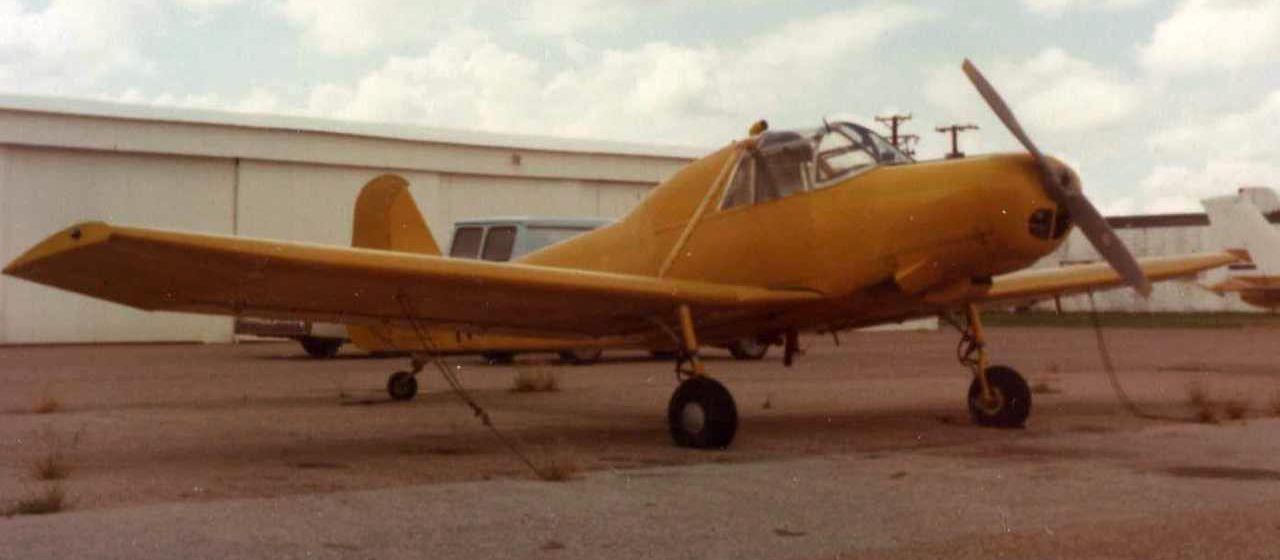
An undated photo of N6810D, 1965 Rawdon T1, serial #T1-36SD, modified into the Spinks Industries AR-31, at Oak Grove Airport.
Bill Daley recalled, “I started work as an instructor at Oak Grove in June 1965.
Jim Couch was the Chief Instructor when I started.
He had replaced Al Pugsley a year or so earlier.
Jim was a great pilot with a colorful & sometimes gruff personality earning him the title 'Eisen Arsch Couch' by some of our German students.
The runway had already been paved when I got there; it was 2,900’ at that time.
The flight school, aircraft sales, maintenance, stores, and manager were all crammed in a single building on the ramp south of the open hangars.”
Bill continued, “The airport expanded rapidly & there was soon a dedicated flight school building
built (actually a nicely renovated surplus barracks moved on premises) around 1966.
Pappy Spinks’ affiliation with Bell Helicopter brought in additional business for the rotorcraft flight school & charter operation run by Jim Hill.
In addition, there was a second helo operation with Max Stone at the Highland Park Airport until its closure.
Bell sent many of their customer’s foreign pilots from around the world to Oak Grove for FAA certificates & additional ratings based on foreign equivalency.
These guys livened up the place both during & after work hours
(Idi Amin’s chief pilot loved the local western-themed nightclubs & needed a chaperone from Bell during his extracurricular time).”
Bill continued, “Jim Couch left for a FAA GADO position in 1969.
I filled the chief instructor/FAR 135 pilot position soon after that.”
Bill continued, “About 1969 an aerobatic curriculum was started for which Pappy brought in Duane Cole with Bobby & Gene Bishop.
In the same period Pappy started work designing & building a competition aerobatic aircraft with Charlie Hillard as chief test pilot & project engineer.”
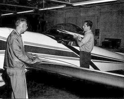
A circa 1967-70 photo (courtesy of Bill Daley) of “Pappy [Spinks] & Charlie [Hillard] with the finished model [of the Spinks Acromaster] at Oak Grove.”
Bill Daley recalled, “The Spinks Aircraft Industries [building was] built in 1968 specifically for the construction of the Spinks Acromaster.
Hillard placed 3rd in it [the Spinks Acromaster] during 1970 World Aerobatic Championships.
The Spinks Acromaster project lasted from 1967-70.
I don't think the plane performed as well as they hoped.
It was a collection of the best attributes from other proven aircraft put together with more operational than engineering expertise & with limited resources.
It was more a passion of Pappy who had the money to bankroll it himself.
It was Charlie's skill that made it sing!”
Bill continued, “In 1969-70 Pappy built a great terminal & administrative building along with additional hangars (one dedicated to his collection).
The flight school was moved to the 2nd floor of the terminal.
About then or shortly thereafter I think the runway was concreted & lengthened.”
Bill continued, “Pappy’s love of aviation had him graciously hosting the National Aerobatic Championships from 1967-71.
These events brought out the giants of aerobatics & aviation from Poncho Barnes to Allen Bean - Charlie Hillard to Harold Krier.
Too many icons to name here, but those were red letter days for us able to rub shoulders with them.”
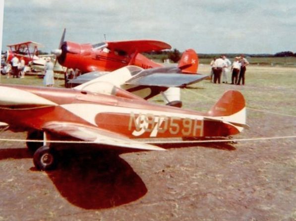
A 1969 photo by Bill Dailey of “aircraft arriving for Nationals” at Oak Grove Airport.
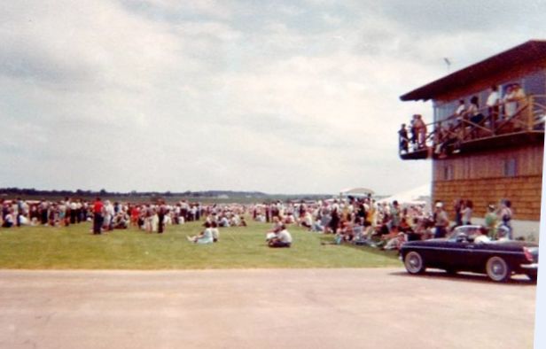
A 1969 photo by Bill Dailey of the “VIP viewing from original headquarters” at Oak Grove Airport.
Bill Daley recalled, “I left [Oak Grove] in 1972.”
The 1968 USGS topo map depicted Oak Grove as having a single north/south paved runway, along with a parallel taxiway,
and a much larger number of hangars than was depicted on the 1963 diagram.
A 1970 aerial view depicted Oak Grove's new paved runway, and an amazing number of hangars.
The 1970 TX Airport Directory (courtesy of Ray Brindle)
depicted Oak Grove as having a 3,050' asphalt Runway 17/35.
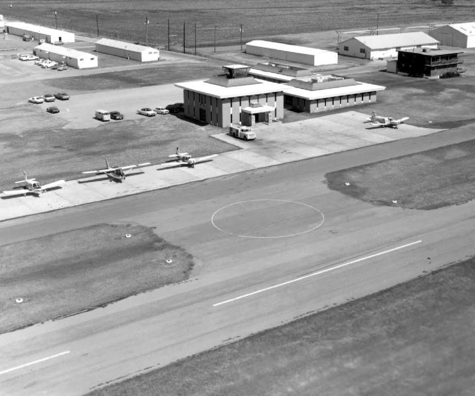
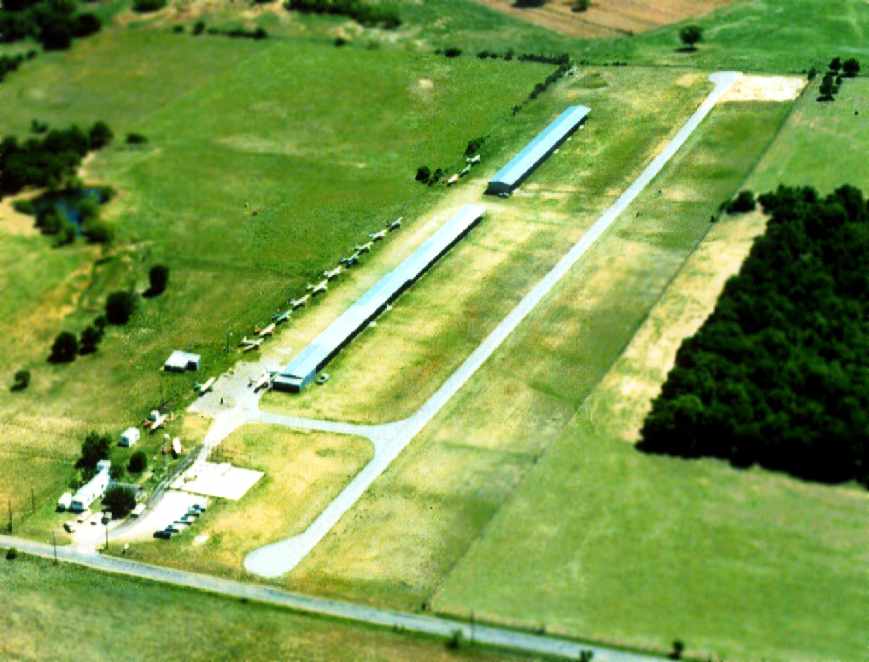
A 1971 aerial view looking northwest at Oak Grove Airport (courtesy of Jerrell Baley),
showing several light aircraft in front of the terminal building.
Note the control tower cab on top of the terminal building (although it doesn't appear as if this airport ever had a staffed tower).
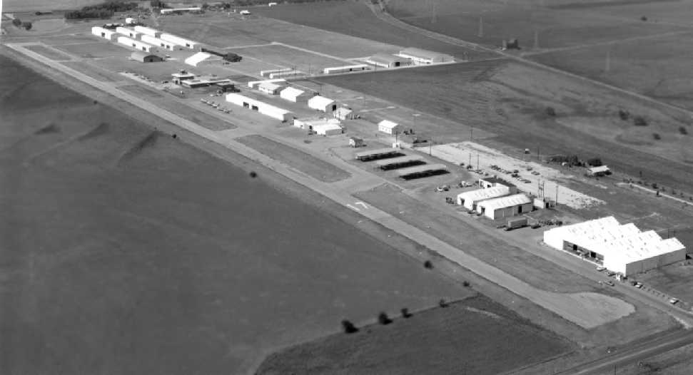
A 1971 aerial view looking southwest at Oak Grove Airport (courtesy of Jerrell Baley).
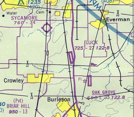
The last aeronautical chart depiction which has been located of Oak Grove Airport was on the July 1976 DFW Terminal Chart (courtesy of Jim Hackman),
which depicted Oak Grove as having a 3,500' paved runway.
By the time of the 1978 DFW Sectional Chart (courtesy of Ray Brindle),
the runway had been lengthened to 3,500'.
Forth Worth area private pilot Rich Wolf reported that "Oak Grove faded away after Pappy Spinks died."
The last photo which has been located showing Oak Grove Airport still in operation was a 1979 aerial view.
It depicted a very well-used airport, with dozens of light aircraft & an amazing number of hangars.
Unfortunately, the fate of this airport was sealed by local politics in the late 1970s.
In an unusual geographic arrangement,
there came to be a total of 3 general aviation airports clustered in close proximity,
as Sycamore Strip & Luck Field were situated within 5 miles to the northwest of Oak Grove.
As nearby Fort Worth grew rapidly in the 1970s,
local government leaders decided that expanded general aviation facilities were needed.
Given that they had 3 small airports to pick from,
did they do the logical thing, by picking one of them to be expanded?
No, they didn't.
In another classic case of TX government waste
(ironically very reminiscent of what happened at nearby Greater Southwest International Airport),
they decided to ignore Sycamore Strip & Luck Field,
and close Oak Grove Airport & replace it with a newly-built field right next door, Spinks Airport.
After all, why reuse & expand the existing infrastructure,
when far more "pork barrel" work can be expended at taxpayer expense by building something right next door from scratch!
The property adjacent to Oak Grove to the west was chosen as the site for the new airport in 1981.
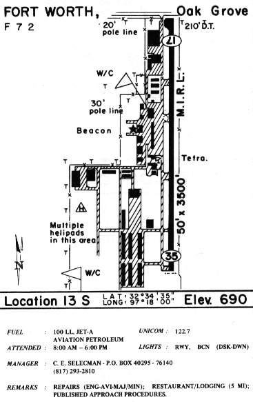
In the diagram of Oak Grove in the 1985 TX Airport Directory (courtesy of Steve Cruse),
hangars had sprouted up all over the west side of the field, totaling over 25 hangars.
The manager was listed as C.E. Selecman.
The southwest portion of the airfield diagram included the note, "Multiple helipads in this area",
which presumably were used by Bell Hueys in conjunction with the skid manufacturing operations on the field.
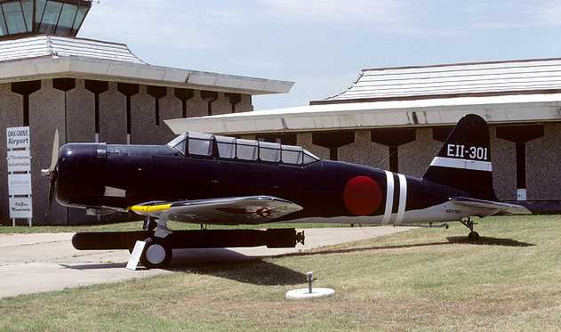
A photo of a North American SNJ-5 modified into a replice of a Nakajima B5N2 torpedo bomber for the movie "Tora, Tora, Tora",
sitting in front of the Oak Grove terminal during the 1986 Fort Worth International Airfest at Oak Grove Airport.

A 10/18/86 photo of N9462Z, a North American TB-25N, serial #44-30535, at Oak Grove Airport during the 1986 Fort Worth Airfest.
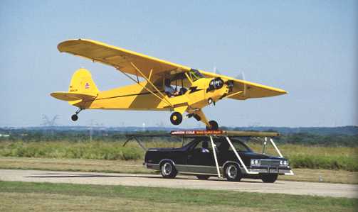
Marion Cole lands his Piper Cub on a platform affixed to the top of a moving Chevy El Camino as part of the “World's Smallest Airport” act
at the 1986 Fort Worth International AirFest at Oak Grove Airport.
Spinks Airport was constructed adjacent to Oak Grove to the west in 1988.
At least the history of the site was acknowledged by naming the new airport after "Pappy" Spinks.
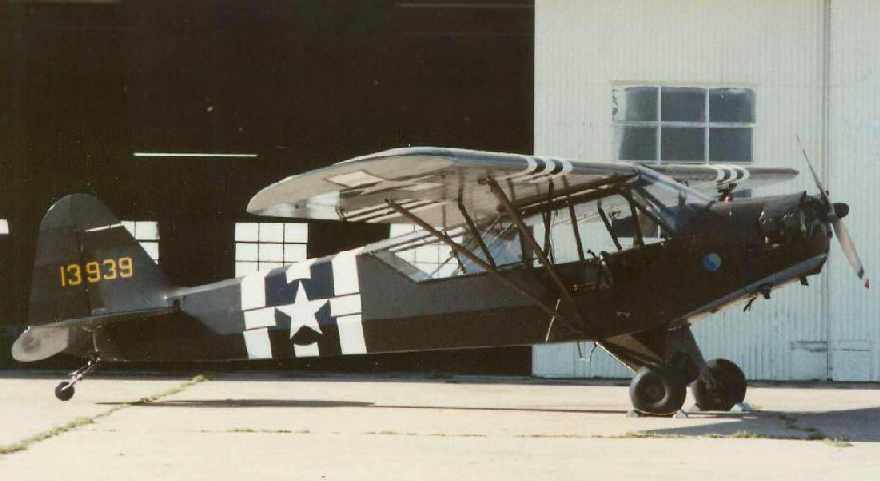
A circa late 1988 - early 1989 photo by Brian Goad of his father's L-4,
in front of Oak Grove's larger hangar directly north of the radar dome.
According to Brian, “This hangar is where the bar & grill scenes of the movie 'Pancho Barnes' were filmed.”
Ken Morris recalled, “Saturday May 27, 1989 at the crack of dawn,
we took off in our Bonanza from Oak Grove Airport for a 3-day get-away.
Sunday 28, a ceremony was held closing Oak Grove & activating Spinks Airport.
Monday May 29, we returned landing at the new Spinks Airport.”
Brian Goad recalled, “There was activity on part of the old side at least until about mid 1989, not the runway, though.
I know because I was in the Civil Air Patrol & one of their planes was based there, and we used the new runway at Spinks.
We also used the old terminal for operations during training missions.”
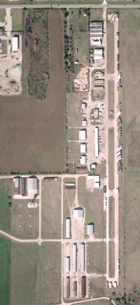
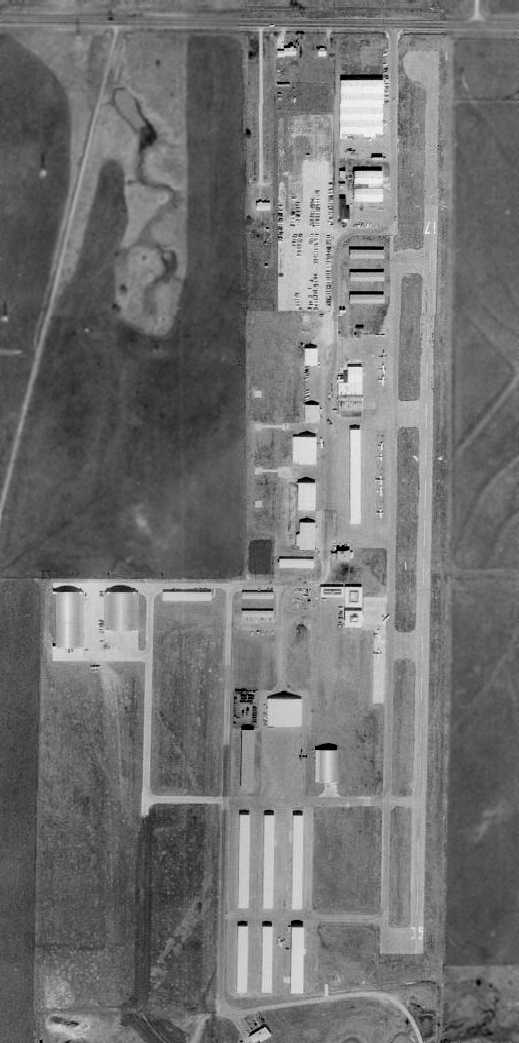
Aerial photo circa 2000.
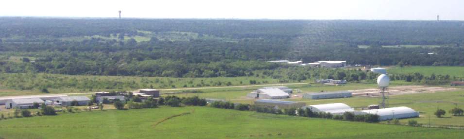
An 8/02 aerial view by Paul Freeman looking southeast at the former Oak Grove Airport.
Thanks to Charlie McClure for the flight.
Paul Freeman visited the site of Oak Grove Airport in 2002, and flew over it as well.
What a waste.
Many municipalities would count themselves lucky to have such an airport,
with a 3,500' concrete runway & a large number of hangars.
Yet this airport sits abandoned, wasting away.
An elegant 2-story building, of relatively-modern construction (apparently the former airport terminal)
sits behind a barbed wire fence, with vines obscuring almost the entire front wall.
What was apparently the home of Pappy Spinks also still stands.
The former manufacturing buildings of ALSCO (where the Bell Huey skids were built)
still stand at the north side of the airport property,
and are being reused by some business.
The concrete runway still exists, in very good condition.
Portions of the runway are used to store trailer homes.
Some of the hangars on the southwestern portion of the airfield are still used by aircraft operating from Spinks Airport
(a taxiway connects them to the Spinks runway).
But the majority of the hangars & other aviation infrastructure at Oak Grove Airport
are separated from Spinks by a high fence.
It is almost as if the local politicians didn't want to be reminded
that all of that aviation infrastructure was already there.
Very strange.
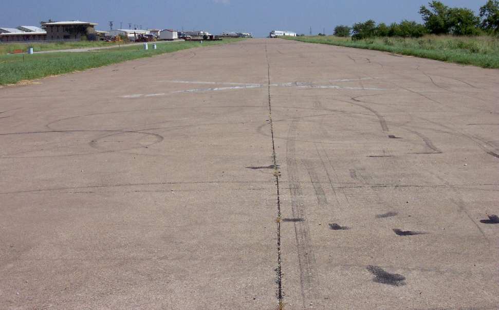
An 8/02 photo by Paul Freeman looking north along Oak Grove's closed Runway 35.
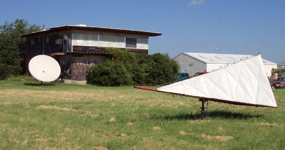
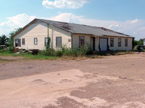
An 8/02 photo by Paul Freeman of Oak Grove Airport's original headquarters building,
with the wind tetrahedron still standing in front.
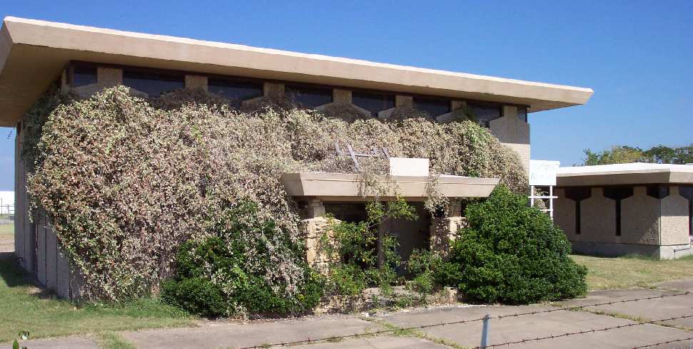
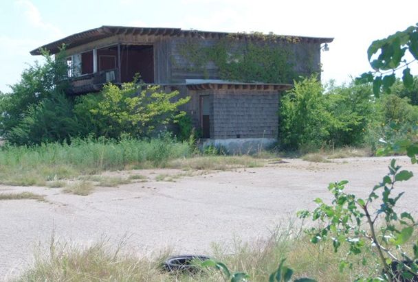
An 8/02 photo by Paul Freeman of the elegant former terminal buildings at Oak Grove Airport, now fenced off & overgrown.
The control tower cab on top of the building was evidently removed at some point between 1971-2002.
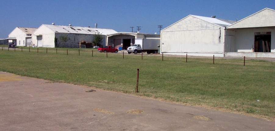
An 8/02 photo by Paul Freeman of the former manufacturing buildings of ALSCO Inc.,
where Huey helicopter skids were built, at the north end of Oak Grove Airport.
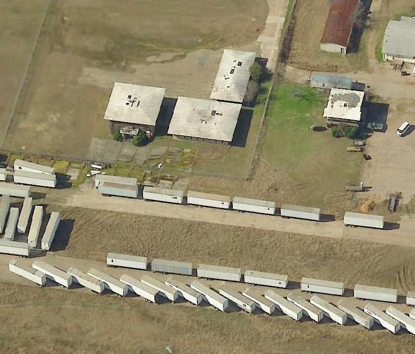
A circa 2002-2005 aerial photo looking west at the former terminal buildings at Oak Grove Airport,
with the former runway in the foreground, covered by trailers.
Charles Trotter recalled, “I was the one that had all those road trailers stored on the runway. At one point we had over 330 trailers on the runways.
I explained to my dad how I needed a location to store a large amount of trailers
and he said a crazy friend of his named Pappy had a closed airport where they would do business & was out of the way.
There was a family that lived in a mobile home near the entrance who we rented the runway from. There seemed to be a family with children living in a house on site too.
I was thankful to get the cheap rent to store the trailers, from 2002-2007.
I used to look at the facility & wonder 'who upset who' because this is a perfectly good FBO facility & it looked like it was abandoned in a hurry.”
An August 2013 photo by Bill Dailey of Oak Grove Airport's original headquarters building,
in a sad state compared to its 1969 photo.
An August 2013 photo by Bill Dailey of Oak Grove Airport's Spinks Aircraft Industries building.
Oak Grove Airport is located south of East Rendon Crowley Road, a half mile east of Interstate 35.
See also: http://www.ftwtexas.com/spinks/spinks1.htm
____________________________________________________
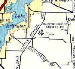
32.687, -97.181 (Southeast of Fort Worth, TX)
A May 1960 photo by Tom Russell (courtesy of Joel Russell)
looking north through Pylon Field's first hangar (under construction), with several aircraft & the office in the background.
No airfield was yet depicted at this location on a 1958 aerial photo.
According to Troy Whistman, “The airfield was built in 1960.
Sid Fisher, and another instructor, Tom Russell, were instructing at nearby Lucas Field.
They got to talking about building their own field to instruct out of, found the property, and went in as partners.”
The earliest depiction which has been located of Pylon Field was a May 1960 photo by Tom Russell (courtesy of Joel Russell)
looking north through Pylon Field's first hangar (under construction), with several aircraft & the office in the background.
According to Joel Russell, “John Stone... made the first landing at Pylon.
According to my Mom Betty, the office building was a 20' x 30' wood frame house that Dad had built.
When the airport began & needed an office, they had it moved by truck & set up.
Mom planted 2 mulberry trees in front of it on the north side.”
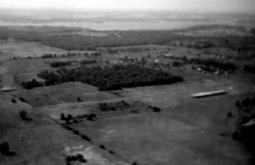
A May 1960 aerial view by Tom Russell looking northwest at Pylon Field
with Lake Arlington in the background (courtesy of Joel Russell),
showing the field having a single runway with a single long hangar.
Joel Russell recalled of Pylon Field, “I was pretty well raised at the airport the first 7 years of my life.
By the age of 3, Mom said I could walk up and down the row of hangars
and tell you what kind, and who the each plane belonged to.
My Dad [Tom Russell] was partners with Sid Fisher, so access was unlimited.
There was always someone there that I could hitch a ride with to go around the patch.
Dad & Sid had thought of buying out 'Pop' Burnham & Lucas Field
but for reasons unknown to me at this time, that didn’t happen.
I do have a letter sent by Burnham Aviation with a list of all properties & price.”
The 1962 AOPA Airport Directory described Pylon Field as having a single 1,800' turf Runway 17/35.
According to Troy Whistman, “Tom sold his interest in 1962 & went on to crop dusting.
He based a clipped-wing Piper on the field at Pylon,
and died there, when an aerobatic routine went wrong & he crashed right in the middle of the runway.”
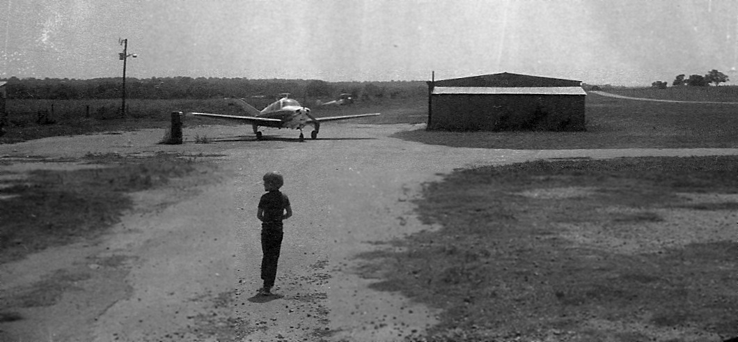
A circa 1962 photo of the the Pylon Field office, a Globe Swift, and a Cessna (courtesy of Joel Russell).
A 1963 photo at Pylon Field of Joel Russell, “a local Pylonite”, a plane on final, the office, and several other planes (courtesy of Joel Russell).
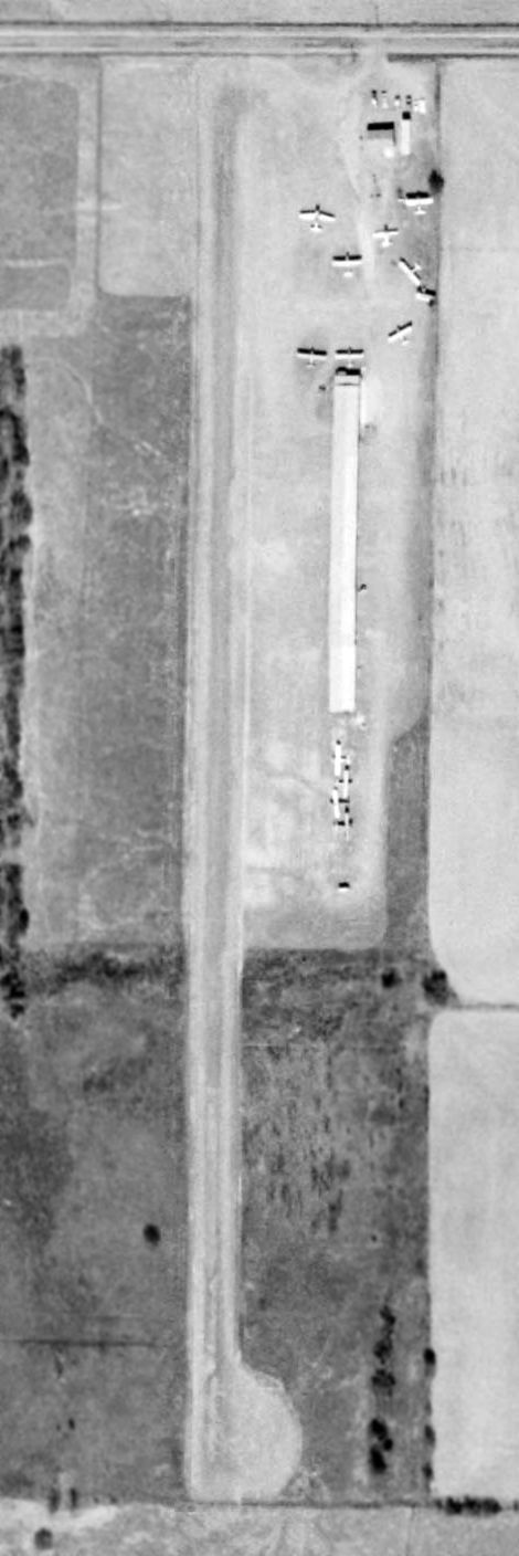
A 1963 aerial view (courtesy of Joel Russell) depicted Pylon Field as having a single grass north/south runway,
with a long hangars & a dozen single-engine aircraft on the northeast side of the field.
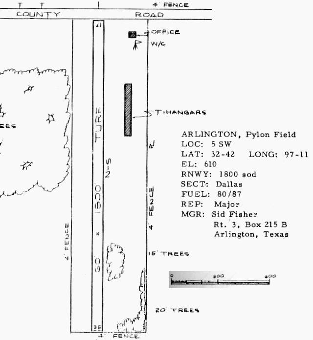
The 1963 TX Airport Directory (courtesy of Steve Cruse) depicted Pylon Field as having a single long t-hangar east of the runway,
and an office on the northeast side, along West Mayfield Drive.
The manager was listed as Sid Fisher.
A 1963 aerial view depicted Pylon Field as having a single grass north/south runway,
with a long hangar & 8 single-engine aircraft on the east side of the field.
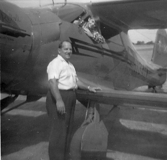
A 1964 photo of George & Gary Tregre with a Beech D-17 Staggerwing “Rebel” at Pylon Field (courtesy of Joel Russell).
Pylon Field, as depicted on a 1965 Enco Oil DFW road map.
Pylon Field was described in basically the same manner on the 1965 Dallas Sectional Chart (courtesy of John Voss).
Joel Russell recalled, “My Dad [Tom Russell] bought a J-3 in Clyde TX to use as a duster for a year or two,
then rebuilt it in our garage in the Poly area of Ft. Worth as a Clip-Wing Cub.
I remember that it was taken to Pops for final assembly and FAA certification
then towed to Lucas for the first flight it made to Pylon.
At that time it was silver with with a red lightning bolt on the side.
Dad had drawings that he had made similar to Charlie Hillard's cub with a red, white and blue sunburst.
That paint never got applied.
On December 20, 1965 he picked me up from school to go to the airport to do some flying.
He was going to practice on his aerobatics, and return to take me up afterwards.
After a pass or two, coming from the south end of the field he began to execute a perfect slow roll
in front of myself, Brady 'Old Man' York and Marvin Dotson.
As he reached the center of the field inverted, and about 50’ above ground level
the carbureted engine sputtered & the plane began to drop like a rock.
I believe he tried to snap roll to the left, but the plane impacted on the nose & right wing.
I remember the sound… like someone dropping a dumpster in a parking lot.
The plane came to rest in show center standing on the nose, facing south.
He was killed on impact.
It was sometime before I was able to return to the airport.”
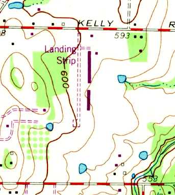
Pylon Field was depicted on the 1968 USGS topo map as a single unpaved north/south runway, labeled simply “Landing Strip”,
with 2 rows of hangars along the east side.
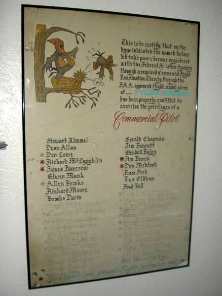
An undated photo by Joel Russell of a poster drawn by John Stone
listing people who received their Commercial tickets at Pylon Airport.
Joel observed, “The names are listed as: Stewart Kimmel, Dean Allen, Don Lowe, Richard McLaughlin, James Harcrow, Glen Mank,
Allen Brooks, Richard Moore, Brooks Davis, Bruce Pettermyer, Charles Starnes, Paul Liscomb, Jim Walraven, Bill Young,
Bill Rowland, Frank Porter, Sid Fitzgerald, Bob Naages, Tom Foster, Terry Sisk, Gerald Chapman, Jim Bennett, Wendell Haley,
Jim Brown, Don Medford, Russ Ford, Tex Oldham, Fred Bell, Don Halpenny, Henery Burkett, John Yandell, Tom Miller,
Hugh Ward, Joe Wildman, Ben Smith, Ed Fortenberry, Ray Fanning, Wes Walls, Gill Woolbridge.”
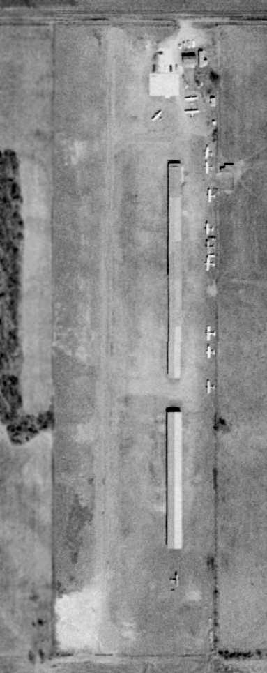
A 1970 aerial view depicted Pylon Field as having a single grass north/south runway,
with several long hangars & a dozen single-engine aircraft on the east side of the field.
The runway at Pylon Field had been paved by the time of the 1970 TX Airport Directory (courtesy of Ray Brindle).
It depicted a 1,764' asphalt Runway 17/35,
along with a paved taxiway east of the runway led to 2 rows of t-hangars.
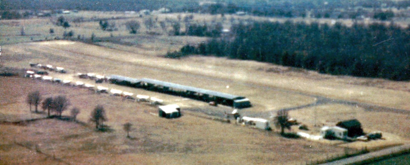
A 1965 aerial view looking southwest showing a healthy number of planes at Pylon Field, and the 2nd set of shorter hangars (left) attached to the original hangars (courtesy of Joel Russell).
An early 1970s aerial view looking southeast at Pylon Field (courtesy of Sid Fisher, via Troy Whistman).
Troy observed the photo was “before the big hangar was built.
You can see the poured pad for the new hangar in the bottom of the picture, to the left of the runway.”
Joel Russell observed, “To the far left is a small metal building. This was in place when the airport property was bought.
Even though it was not located ON the airport site it was used by Dad [Tom Russell] to park his Luscombe at the beginning.
The trailer home next to the office is where Sid & his family lived until they built a new home several miles east of the airport.
South of the trailer and next to a 150 is a small portable building that was used as the ground school classroom.”
Charles Mitchell recalled, “I took my flight training at Arlington Municipal Airport
at Southwest Executive Air Flight School during the early 1970s.
At about 20 hours into my flight training my instructor, Joe Waddell,
told me we were going to fly over to Pylon for some short-field landings.
Me, being a naive youth of 25 years, wide-eyed & innocent, full of bravado, did not know what I was in for.
In my naiveté, I had become used to the full length of Arlington Municipal
and having the luxury (whilst on final approach) of taking all morning to decide
which part of the runway I wanted to touch down on when landing.”
Charles continued, “As we crossed over Pylon my instructor pointed to the runway.
All I saw was a gray smudge running north to south with a very long awning along the east side.
I looked at my instructor as he gazed serenely back as if to say, 'Yes... you... and yes... that is an airport!'”
Charles continued, “I think I must have aged 5 years as I turned from base leg to final.
As I neared the north end of the runway I noticed that there were power lines adjacent to the north end of the runway.
The electrical company had been gracious enough to bury the power lines
so as to clear the north end of the touch-down area.
On that first approach I formed the opinion that the power company was either cheap or lazy
as I would have sworn on all the Bibles in Texas that there was no more than the thickness of a postage stamps clearance
between the power poles & the wing tips of that venerable old Cessna 150.”
Charles continued, “After the 3rd approach (sweating profusely, gray hair sprouting at my temples),
with the sage advice of my instructor ('more power... back on the yoke a little bit... ease off the power...
GETCHA FOOT OFF THAT RUDDER!!!', etc.)
I was able to mimic at what would pass for a landing.”
Charles continued, “Just before my landing, I spotted Sid Fisher standing in the door of the 'shack'.
After offering up thanks to The Almighty, Bhudda, Wakan-Tanka, and whatever deity happened to be listening at the moment
we taxied down the sod next to the runway & shut down by the shack.
Mr. Fisher chuckled & offered the opinion that he thought he was going to have to shoot a wing off to get me on the ground at Pylon.
He clapped me on the shoulder and told me that 'every landing at Pylon is a short field, spot landing'
and finished by telling me I did fairly good for a student pilot.”
Charles continued, “From that point, as I progressed in my training,
I considered Pylon Airport a personal challenge and a way to refine my skills at short field & spot landing.
I spent several of my solo hours landing at that airport.”
Pylon Field was still depicted on the 1973 USGS topo map.
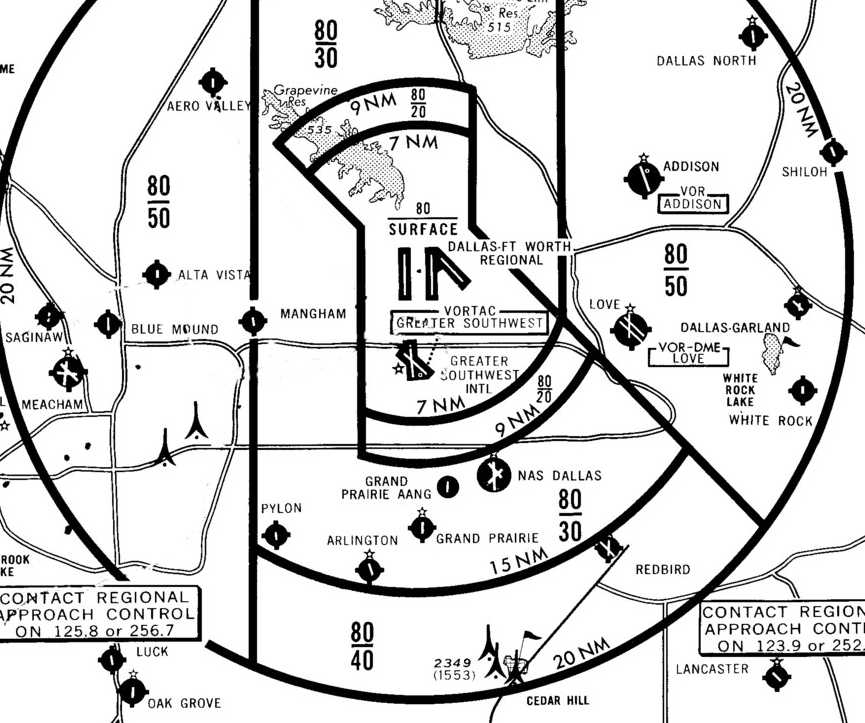
Pylon Field, as depicted on a 1973 DFW Terminal Control Area Chart (courtesy of Fred Fischer).
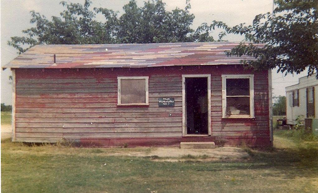
A circa mid-1970s photo of the “Pylon International Office” (courtesy of Joel Russell).
According to Troy Whistman, “The school district purchased the property in 1973 & gave them 2 years of usage.
Sid says that the last person to solo at the field was Roger Dellinger.
The last flight out was in the spring of 1975.”
A 1976 photo Curt Fisher in front of a Bonaza - the last plane out of Pylon Field (courtesy of Joel Russell).
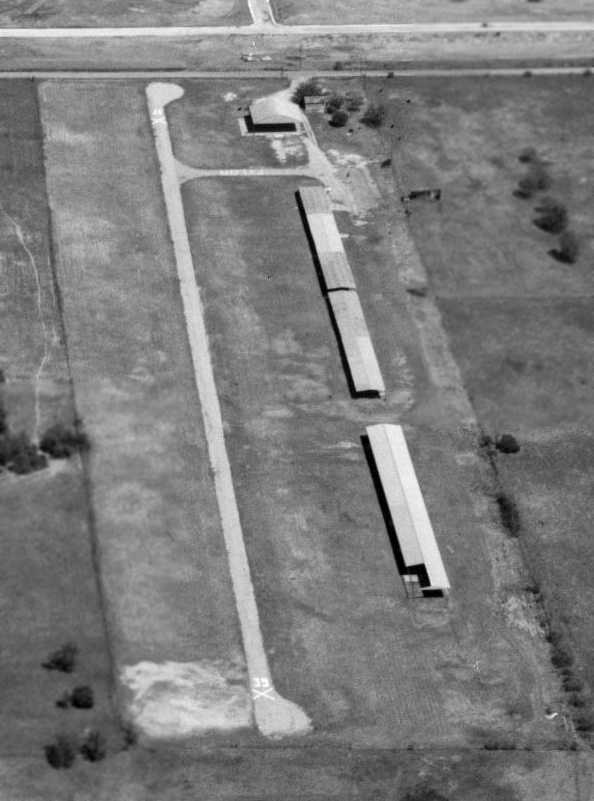
The last photo which has been located of Pylon Field was a 3/27/76 aerial view looking northeast (courtesy of Jerrell Baley).
The field was still intact, with a single runway & 2 long T-hangars,
but no aircraft were visible on the property.
Pylon Field was no longer depicted at all (not even as an abandoned airfield)
on the July 1976 DFW Local Chart (courtesy of Jim Hackman).
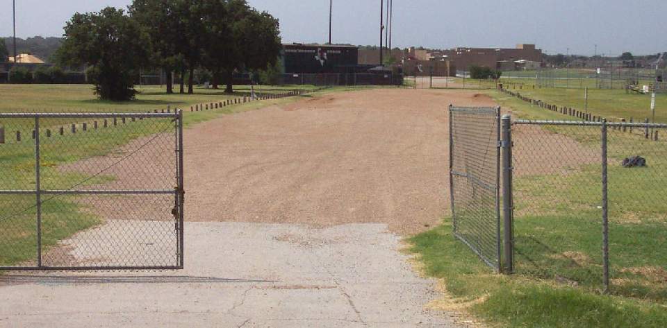
A 8/02 photo by Paul Freeman looking south at the site of Pylon Field,
with Martin High School visible in the background.
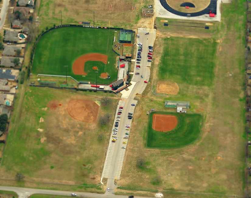
A circa 2002-2005 aerial view looking south at the site of Pylon Field.
According to Joel Russell, one of the mulberry trees planted by his mother
“is still there although looking every bit of its 50 hard years old.
This tree appears right of the parking area & below the ball diamond.”
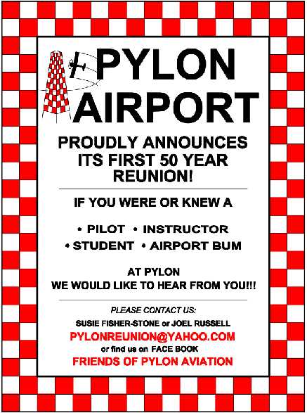
A flier for the planned 2013 “first 50 year reunion” for those associated with Pylon Airport,
planned by Joel Russell, son of Pylon Field's founder.
Joel reported, “I am trying to get people together who were associated with Pylon for a reunion.
We have decided to make this a go for June 22.
It will be hosted at the Grand Prairie Airport terminal.
Several have mentioned flying in so it will give the others something to go out to the ramp, make airplane noises while waiving their hands around...lol.”
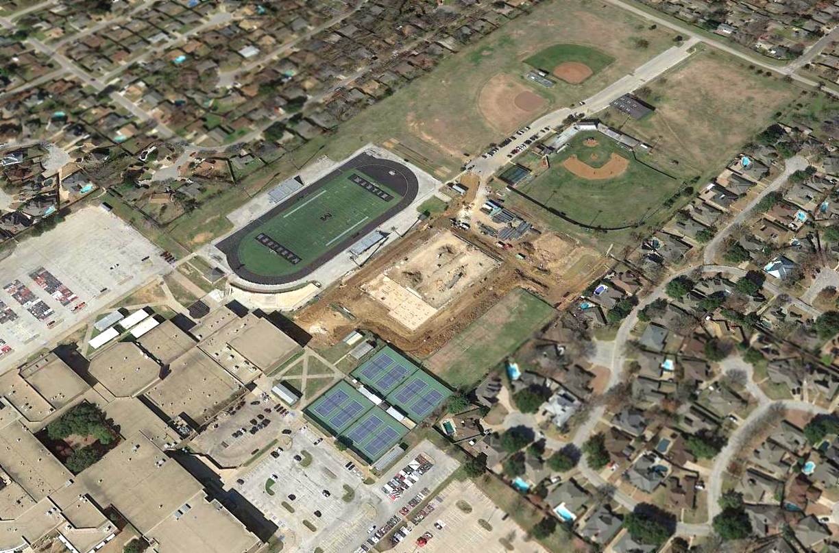
A 2016 aerial view looking northwest at the site of Pylon Field.
According to Joel Russell, “The runway would align very close to the west side of the running track.
There is a line of trees east of the parking area that coincide to the row shown in Sid's photo out in the pasture to the east.”
The site of Pylon Field is located southeast of the intersection of West Mayfield Road & French Wood Drive.
____________________________________________________
Since this site was first put on the web in 1999, its popularity has grown tremendously.
That has caused it to often exceed bandwidth limitations
set by the company which I pay to host it on the web.
If the total quantity of material on this site is to continue to grow,
it will require ever-increasing funding to pay its expenses.
Therefore, I request financial contributions from site visitors,
to help defray the increasing costs of the site
and ensure that it continues to be available & to grow.
What would you pay for a good aviation magazine, or a good aviation book?
Please consider a donation of an equivalent amount, at the least.
This site is not supported by commercial advertising –
it is purely supported by donations.
If you enjoy the site, and would like to make a financial contribution,
you
may use a credit card via
![]() ,
using one of 2 methods:
,
using one of 2 methods:
To make a one-time donation of an amount of your choice:
Or you can sign up for a $10 monthly subscription to help support the site on an ongoing basis:
Or if you prefer to contact me directly concerning a contribution (for a mailing address to send a check),
please contact me at: paulandterryfreeman@gmail.com
If you enjoy this web site, please support it with a financial contribution.
please contact me at: paulandterryfreeman@gmail.com
If you enjoy this web site, please support it with a financial contribution.
____________________________________________________
This site covers airfields in all 50 states.