
Abandoned & Little-Known Airfields:
Virginia: Southern Richmond area
© 2002, © 2015 by Paul Freeman. Revised 1/14/15.
____________________________________________________
Please consider a financial contribution to support the continued growth & operation of this site.
Berkeley Field (revised 1/14/15) - Colonial Heights Airport (revised 1/14/15) - Hopewell Airport (revised 1/14/15) - Parnell Airport (revised 1/14/15)
____________________________________________________
Colonial Heights Airport, Colonial Heights, VA
37.248, -77.391 (Southeast of Richmond, VA)
A 9/10/43 aerial view looking west at Colonial Heights Airport from the 1945 AAF Airfield Directory (courtesy of Scott Murdock).
This small general aviation airport may have been established at some point between 1937-43,
as it was not listed among active airfields in The Airport Directory Company's 1937 Airport Directory (courtesy of Bob Rambo).
Colonial Heights Airport was not depicted on USGS topo maps from 1942, 1944, 1945, or 1946.
The earliest depiction which has been located of Colonial Heights Airport
was a 9/10/43 aerial view looking west from the 1945 AAF Airfield Directory (courtesy of Scott Murdock).
It depicted Colonial Heights as having 2 unpaved runways.
The 1945 AAF Airfield Directory (courtesy of Scott Murdock) described Colonial Heights Airport
as a 140 acre irregularly-shaped property having 2 sod runways, measuring 2,500' northeast/southwest & 2,000' north/south.
The field was said to not have any hangars, and to be owned & operated by private interests.

The earliest aeronautical chart depiction which has been located of Colonial Heights Airport
was on the 1945 Norfolk Sectional Chart (courtesy of John Voss).
It depicted Colonial Heights as a commercial/municipal airport.
The 1945 AAF Airfield Directory (courtesy of Scott Murdock) described Hopewell Airport
as a 194 acre irregularly-shaped property within which were 3 sod runways, the longest being a 2,400' northwest/southeast strip.
The field was said to have a single 66' x 60' wood & steel hangar,
to be owned by the City of Hopewell, and to be privately operated.
According to the book "Virginia Airports" by Vera Rollo & Norman Crabill (published by the VAHS),
“Colonial Heights Airport... private-commercial operation with 2 turf strips.
Application for license applied for 12/28/45; granted 2/28/46.”

The last aeronautical chart depiction which has been located of Colonial Heights Airport
was on the April 1946 Norfolk Sectional Chart (courtesy of Jim Stanton).
It depicted Colonial Heights as a commercial/municipal airport.

The last depiction which has been located of Colonial Heights Airport was on the 1949 USGS topo map.
It depicted Colonial Heights as a commercial/municipal airport.
According to the book "Virginia Airports" by Vera Rollo & Norman Crabill (published by the VAHS),
“Colonial Heights Airport... license canceled 6/6/49, as operator W.T. Combs moved to operate the Harkrader-Kilgore Airport.”
Colonial Heights Airport was no longer depicted on the 1952 USGS topo map
nor on the 1954 Norfolk Sectional Chart.
The 1959 USGS topo map presumably showed another reason for the closure of Colonial Heights Airport:
the western portion of the airfield property had been covered by the new Interstate 95.
A 1968 aerial photo showed what appeared to be the outline of the former north/south runway,
adjacent to the east side of Interstate 95.
A 1994 USGS aerial photo showed that commercial buildings had covered the site,
erasing any trace of Colonial Heights Airport.

A 10/21/12 aerial view did not show any trace of Colonial Heights Airport.
The site of Colonial Heights Airport is located northeast of the intersection of Interstate 95 & Southpark Boulevard.
____________________________________________________
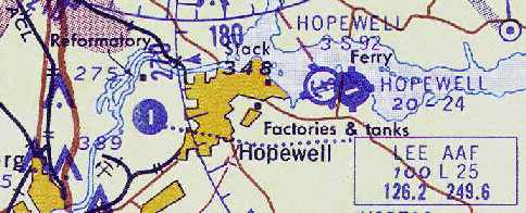
Hopewell Airport (W89), Hopewell, VA
37.306, -77.22 (Southeast of Richmond, VA)

Hopewell Airport, as depicted on the 1935 Norfolk Airway Chart..
This small former airport was located on Jordan Point,
which juts from the southern shore of the James River.
Jordan Point was named after Samuel Jordan, who lived there in 1619.
It was acquired by Theodorick Bland in 1656.
In 1671 Richard Bland I inherited the plantation, then Richard Bland II in 1720.
According to the book "Virginia Airports" by Vera Rollo & Norman Crabill (published by the VAHS),
an operating license for a "City of Hopewell Municipal Airport" was applied for on 4/18/28,
and was granted on 6/15/31 [even back then the bureaucracy took three years to approve an application!].
The earliest directory reference to the airfield which has been located
was in The Airport Directory Company's 1933 Airport Directory (courtesy of Chris Kennedy).
It described Hopewell as a municipal airport, consisting of a triangular 194 acre sandy clay field,
measuring 3,150' northwest/southeast, 2,700' northeast/southwest, and 2,550' east/west.
A seaplane ramp was said to adjoin the airport.
The 1934 Department of Commerce Airfield Directory (according to Chris Kennedy)
described Hopewell Airport as being a triangular sandy clay field,
measuring 2,200' north/south x 1,800' east/west.
A seaplane ramp was said to adjoin the airport.

The earliest depiction of the Hopewell Airport which has been located was a 1936 aerial view, looking north at the field.
It depicted Hopewell as having a single north/south runway.

An aerial view of Hopewell Airfield
from the Airport Directory Company's 1937 Airports Directory (courtesy of Bob Rambo).
The directory described Hopewell Airport as having a single 2,000' gravel northeast/southwest runway,
and a seaplane ramp adjoining the airport.
The first airmail was flown from Hopewell on 5/20/38,
according to the book "Virginia Airports".
During WW2 an airplane factory was reportedly built at Hopewell Airport (by whom, and for what type of aircraft?),
but was abandoned as the war ended, according to the book "Virginia Airports".

A circa 1942-45 aerial view looking southwest at Hopewell Airport from the 1945 AAF Airfield Directory (courtesy of Scott Murdock)
depicted the field as having several grass runways.
In 1944, the airport was purchased by the city from Herbert Powell.

Hopewell was depicted as a commercial or municipal airport
on the April 1945 Norfolk Sectional Chart (courtesy of Chris Kennedy).
The 1945 AAF Airfield Directory (courtesy of Scott Murdock) described Hopewell Airport
as a 194 acre irregularly-shaped property within which were 3 sod runways, the longest being a 2,400' northwest/southeast strip.
The field was said to have a single 66' x 60' wood & steel hangar,
to be owned by the City of Hopewell, and to be privately operated.
The July 1953 Chesapeake Bay USAF World Aeronautical Chart (courtesy of Chris Kennedy)
depicted Hopewell as having a 2,800' hard surface runway.

The 1953 USGS topo map depicted Hopewell Airfield
as having a single northeast/southwest runway & several buildings & a seaplane ramp along the west side.
Hopewell Airfield was depicted on the 1960 USGS topo map with a single east/west runway,
a single hangar at the west end of the runway,
and a seaplane ramp on the opposite side of Route 156.
The 1961 Norfolk Sectional Chart (courtesy of Chris Kennedy)
depicted Hopewell as having a 2,400' paved runway, oriented northeast/southwest,
as well as an adjacent seaplane base.
The Aerodromes table on the 1965 Norfolk Sectional Chart (courtesy of John Voss)
described the field as having three runways, with the primary being a 2,418' asphalt strip.
The only runway depicted on the chart itself was the east/west runway.
In 1968, Hopewell Airport was operated by Dr. Daugherty & Jay Ipson.
Don Cummins was an instructor at Hopewell, and he had a 7AC Champ on floats on the river.
Hopewell was depicted as an active airfield on the 1970 Washington Sectional Chart (courtesy of John Clifford),
with two paved runways (the longest being 3,500').

The 1970 VA Airport Directory (courtesy of Stephen Mahaley) described Hopewell Airport
as having two paved runways (with the longest being the 3,500' Runway 15/33) and two turf runways.
a single 2,600' turf Runway 15/33.
Two hangars, a shop, and an office were depicted along the west side of the field,
and the Hopewell Seaplane Base was depicted on the opposite side of the road.
The airport was said to offer flight instruction, charter, and maintenance.
It listed the operator as Americana Aviation,
and the manager was listed as J. M. Ipson.
William Drumright recalled, "In the 1972-74 time frame,
I flew with the Civil Air Patrol Squadron based in Hopewell.
For most of that period, we used the Hopewell Airfield.
It was from this field that we made at least one flight up to the State Police field on the outskirts of Richmond.
That flight was part of a training exercise with the scenario being that we were to land,
pickup some urgently needed blood in containers, and fly them to the desired location.
Our flight was conducted in a former Air Force L-19."

A September 8, 1973 aerial view by Kenneth Keeton looking southeast at Hopewell Airport.

An undated photo by Kenneth Keeton of his 1962 Cessna 172C N8249X at Hopewell Airport.

Hopewell Airport, as depicted on the 1975 Washington Sectional Chart (courtesy of Ed Drury).
Hopewell was described in the 1982 AOPA Airport Directory (courtesy of Ed Drury)
as having two asphalt runways: 3,345' Runway 15/33 & 2,405' Runway 8/26.
According to the book "Virginia Airports", a 1982 article described how the Hopewell Airport
would be used as an ultralight flight park, "Virginia Wings Ultra Flight Park".
It was planned to be open to the public in 1983,
but it has not been determined if these plans were ever realized.
William Drumright recalled, "The last time I was at the Hopewell Airport was just after it had been declared closed
and the construction was beginning on the subdivision which replaced it.
The old hangar was still standing & it was being used for a rather unusual event.
There was a small circus in town, but the weather was wet & windy
and led to cancellation of all but the 'Main Attraction'.
The Main Attraction was the performer named 'Tiny Tim' of ukulele & the Johnny Carson Tonight Show fame.
It was cold & windy inside the hangar, but his show did happen."
Hopewell Airport was apparently closed prior to 1989,
as a 1989 aerial photo showed that the property had been redeveloped as a housing development, Jordan on the James,
with not a trace remaining of the former airport.
Hopewell Airport was no longer depicted at all (not even as an abandoned airfield)
on the 1991 Washington Sectional Chart (courtesy of Mike Keefe).

A 1995 aerial view looking southwest at the site of Hopewell Airport
showed that the property had been redeveloped as a housing development,
with not a trace remaining of the former airport.

This is a perfect example of why you can’t always trust maps - this is the USGS topo map from 1996.
The 1996 map still depicted the Hopewell Airfield,
even though pictures from 2 years prior showed that it had already been replaced by a housing development.

A 10/21/12 aerial photo showed that no trace of Hopewell Airport remains.
The site of Hopewell Airfield is located east of Route 156, along the south bank of the James River.
____________________________________________________
Berkeley Field (7W5), Charles City, VA
37.318, -77.172 (Southeast of Richmond, VA)

Berkeley Field, as depicted on the 1972 USGS topo map
(which ironically used the symbol of a 4-engine swept-wing airplane, not very appropriate for a tiny grass-runway airfield).
This small airfield on the north shore of the James River was evidently established at some point between 1965-70,
as it was not yet depicted on a 1963 aerial photo, the 1965 Norfolk Sectional Chart, or the 1967 USGS topo map.
It sits adjacent to Berkeley Plantation, the birthplace of President William Harrison.
Ron Plante recalled that Berkeley Field was "where I learned to fly in 1970-71 while stationed at Ft Lee.
It was a grass strip with Runway 6/24.
Jay Ipson owned Americana Aviation, which had a trailer & gas pumps.
I flew both Cessna 150s & the 172 but not the high-performance single (Mooney?)."
Richard Anderson recalled, “I learned to fly there in June 1972 with a dozen other Civil Air Patrol cadets
who attended the 1972 Virginia Wing Cadet Solo Encampment.
We lived in the barracks at Ft. Lee for 2 weeks
and were bused back & forth to Berkeley Plantation Airport (in fact, I was the bus driver at the ripe old age of 17!).
We had a huge graduation ceremony on 7/1/72 at the southwest corner of the runway
at a memorial erected by the American Legion in commemoration of the writing of the song 'Taps' on the very site of the airport.
The airport was operated by Jay Ipson, who is the same Jay Ipson who ran Americana Aviation at the Hopewell Airport.
He was the Cadet Solo Encampment commander in 1972 when I learned to fly.”

The 1974 USGS topo map depicted Berkeley Field as a single unpaved northeast/southwest runway, labeled simply as "Landing Strip".

Berkeley Field, as depicted on the 1975 Washington Sectional Chart (courtesy of Ed Drury).
The 1975 USGS topo map depicted Berkeley Field as having a single unpaved northeast/southwest runway, labeled simply as “Landing Strip”.

"Berkeley Plantation" Airport was depicted in the 1979 Flight Guide (courtesy of Chris Kennedy)
as having a single 3,200' unpaved Runway 6/24,
with a single building at the northeast corner of the field.

The earliest photo which has been located of Berkeley Field was a 3/13/79 USGS aerial view.
It depicted Berkeley as having a single northeast/southwest grass runway.
"Berkeley Plantation" Airfield was listed in the 1982 AOPA Airports USA Directory (courtesy of Ed Drury),
and was described as having a single 3,200' turf Runway 6/24.
The single runway of Berkeley Field was still depicted on the 1984 USGS topo map,
but it was labeled merely as "Landing Strip",
which most likely means that the airfield was closed by that point.
Berkeley Field was definitely closed by 1991,
as it was no longer depicted at all on the 1991 Washington Sectional Chart (courtesy of Mike Keefe).

A 3/11/94 USGS aerial view looking west depicted Berkeley's single grass runway as remaining intact & in serviceable condition,
but there did appear to be any buildings, aircraft, or sign of any recent usage.

The single runway of Berkeley Field was still depicted on the 1996 USGS topo map,
but it was labeled merely as "Landing Strip".

A 2007 photo by Richard Anderson looking northeast along Berkeley's former Runway 6.
Richard reported, “On March 23, 2007, I drove to Berkeley Plantation Airport
and walked the runway for the first time in 35 years.
The runway is now overgrown with a foot of grass & tall trees now encroach along both sides of the runway.
In an emergency, an airplane could probably land there to this day.
My walk down that runway late on the afternoon of March 23, 2007, just before dark & all alone,
made me long for a simpler day in the life of general aviation in America.
The memories were thick as flies & would have been impossible to brush away.”

A 2007 photo by Richard Anderson,
who observed, “Amazingly, the wind tee still stands halfway down the runway & freely swings on its stand.”

A 2007 photo by Richard Anderson,
who observed, “Remnants of the runway lighting cones still exist in shallow standing water along the runway edge
and are almost covered by tall grass.”

A 10/21/12 aerial view looking west showed Berkeley's single grass runway appeared to remain intact & in serviceable condition.
The site of Berkeley Airport is located at the southern end of Harrison Landing Road
(where it ends at the James River).
____________________________________________________
37.47, -77.454 (South of Downtown Richmond, VA)

A circa late-1940s aerial view of a Goodyear blimp at Parnell Airport.
According to the Richmond Times-Dispatch, Parnell Airport opened in March of 1946.
According to an undated [presumably 1946] newspaper article in the VAHS collection (courtesy of Lyle Browning),
“A former beautician & a prominent lawyer, both of whom were bitten by the aviation bug are now partners in Sky Service Corp.,
and operators of Parnell Airfield at Stop 12 on the Petersburg Pike.
Thurmond (Herman) Hedgepeth is the ex-beautician & Pinckney Sowers is rapidly becoming known around legal circles in Richmond as the 'Flying Lawyer'.
Sowers & the late Clarence Parnell were partners in an aviation venture at Midway Field near Chester in 1941.
Parnell Airfield is located 3 blocks to the right of the Petersburg Pike, going toward Petersburg.
It was opened in May & has 2 runways: 2,800' northwest/southeast & 1,500' east/west.
The field was zoned by the Chesterfield Board of Supervisors as a permanent airport.
At the present there is 1 large cinderblock hangar, office & a pilot lounge.
Six more private hangars will be erected as soon as materials become available.
Melvin Williams, a former Glenn L. Martin employee who holds a CAA certificate & engine rating, heads the maintenance shop at Parnell.”
The earliest depiction of Parnell Airport which has been located was a late 1940s aerial view,
which depicted a Goodyear blimp moored next to an arch-roofed hangar at Parnell.
According to a 1/2/50 Richmond News Leader article (courtesy of Lyle Browning),
“Parnell Airport... has 85 acres of cleared land, 3 dirt runways, one of which is 2,800' long,
a cinderblock building for pilots & offices, a hangar for the storage of 9 planes & 10 T-hangars.
The business is a joint venture of Pinckney Sowers, an attorney, and Thurmond Hedgepeth.
About 200 students have been taught to fly at Parnell, which also charters flights & services small planes.”
Parnell was later operated by well-known Richmond area aviation personalities Hunter & Sherry Jones,
according to the book "Virginia Airports".
The earliest chart depiction of Parnell Airport which has been located
was on the June 1951 Norfolk Sectional Chart (according to the book "Virginia Airports").
The July 1953 Chesapeake Bay USAF World Aeronautical Chart (courtesy of Chris Kennedy)
depicted Parnell as having a 2,700' unpaved runway.

The July 1954 Norfolk Sectional Chart (courtesy of Chris Kennedy)
depicted Parnell Airport as having a 2,700' unpaved runway.

A January 1957 photo of Mrs. Hunter Jones being towed behind a ski-equipped Aeronca which was visiting Parnell Airport.
According to the Richmond Times-Dispatch, at its peak Parnell Airport was home to as many as 30 aircraft.
A series of photos in the book "Virginia Airports" documented how quadriplegic pilot Sammy Gregorio
was able to fly a specially modified Ercoupe from Parnell Airport.
He had been instructed by Hunter Jones,
who was shown lowering Gregorio into the Ercoupe with the assistance of his wife Sherry Jones.
The Aerodromes table on the 1965 Norfolk Sectional Chart (courtesy of John Voss)
described Parnell as having a single 2,750' turf runway.

The last photo which has been located showing Parnell Airport in operation was a 2/25/68 USGS aerial view.
It depicted the field as having a single northwest/southeast grass runway,
with 3 hangars & 3 light aircraft on the northeast corner.

The 1970 VA Airport Directory (courtesy of Stephen Mahaley)
depicted Parnell Airport as consisting of a single 2,750' turf Runway 15/33.
A hangar & office and another 2 hangars were depicted on the northeast side of the runway.
The field was said to offer flight instruction, charter, and maintenance.
The operator & manager were listed as D. H. Jones.

Parnell Airport was still depicted as an active airfield
on the 1972 Washington Sectional Chart (courtesy of Mike Keefe).
According to the Richmond Times-Dispatch, Parnell Airport closed in 1972.
Parnell Airport was was no longer depicted on the 1975 Washington Sectional Chart (courtesy of Ed Drury).

The site of Parnell Airport was covered with several large buildings at some point between 1972-92,
as a 1992 aerial view looking east at the site showed that not a trace appeared to remain of the former airport.

A 10/21/12 aerial photo showed no trace appears to remain of Parnell Airport.
The site of Parnell Airport is located south of the intersection of East Belt Boulevard & Bells Road.
____________________________________________________
Since this site was first put on the web in 1999, its popularity has grown tremendously.
That has caused it to often exceed bandwidth limitations
set by the company which I pay to host it on the web.
If the total quantity of material on this site is to continue to grow,
it will require ever-increasing funding to pay its expenses.
Therefore, I request financial contributions from site visitors,
to help defray the increasing costs of the site
and ensure that it continues to be available & to grow.
What would you pay for a good aviation magazine, or a good aviation book?
Please consider a donation of an equivalent amount, at the least.
This site is not supported by commercial advertising –
it is purely supported by donations.
If you enjoy the site, and would like to make a financial contribution,
you
may use a credit card via
![]() ,
using one of 2 methods:
,
using one of 2 methods:
To make a one-time donation of an amount of your choice:
Or you can sign up for a $10 monthly subscription to help support the site on an ongoing basis:
Or if you prefer to contact me directly concerning a contribution (for a mailing address to send a check),
please contact me at: paulandterryfreeman@gmail.com
If you enjoy this web site, please support it with a financial contribution.
please contact me at: paulandterryfreeman@gmail.com
If you enjoy this web site, please support it with a financial contribution.
____________________________________________________
This site covers airfields in all 50 states.