
Abandoned & Little-Known Airfields:
West Virginia: Northeastern
© 2002, © 2016 by Paul Freeman. Revised 3/26/16.
This site covers airfields in all 50 states: Click here for the site's main menu.
____________________________________________________
Please consider a financial contribution to support the continued growth & operation of this site.
Burlington Airport / Baker Air Park (revised 3/26/16) - Dawson AAF (1st location) (revised 9/23/12) - Keyser Airport (revised 6/29/15)
Rexroad Airfield (1st location) (added 10/19/08) - Rexroad Airfield (2nd location) (revised 3/7/16) - Thomas Airfield (revised 10/19/15)
____________________________________________________
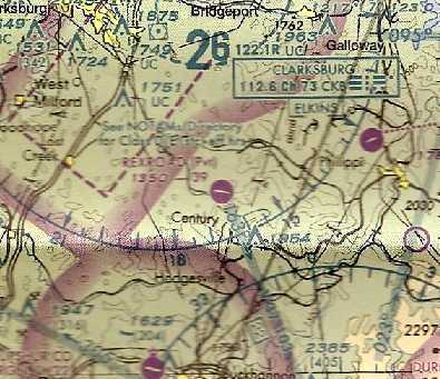
39.16, -79.51 (Northwest of Washington, DC)
A 4/12/56 USGS aerial photo depicted Thomas Airfield as having a single unpaved northwest/southeast runway.
Not much is known about this small rural airfield, including its date of construction, purpose, or name.
The earliest depiction which has been located of Thomas Airfield was a 4/12/56 USGS aerial photo,
which depicted a single unpaved northwest/southeast runway.
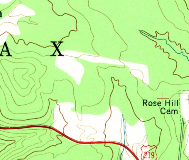
The 1959 USGS topo map depicted the northwest/southeast clearing of the Thomas Airfield runway, but did not label the airfield.
The Thomas Airfield was not depicted at all on the 1960 Huntington Sectional Chart.

The 1995 USGS topo map depicted Thomas Airfield as a single northwest/southeast runway, labeled simply as “Landing Strip”.
The Thomas Airfield was not depicted at all on the July 2001 Cincinnati Sectional Chart (courtesy of Rick Harshbarger).

A circa 2010 aerial view looking south depicted a single T-hangar on the south side of the Thomas Airfield runway.
The T-hangar appeared to be open on the north side, but it was not evident if there was an aircraft inside.
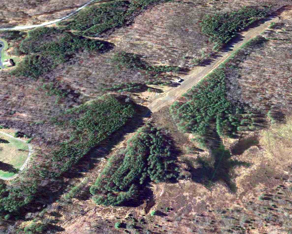
An 11/19/13 aerial view looking southwest depicted the Thomas Airfield runway & T-hangar as remaining intact,
but there was no sign of any recent aviation use.
As of 2015, there was no airfield in Thomas registered with the FAA.

A 2015 photo by Rick Harshbarger looking northwest from the midpoint of the Thomas Airfield runway.
Rick reported, “It wasn't as easy to find as I thought, but with the help of a worker at the Thomas town hall, I eventually found it.
It's in MUCH better shape than I thought it would be. There are no aircraft there, but the runway is in very good shape.
I guesstimate the strip to be 2,750' x 80'. It appears to be rolled & mowed.
They've extended it to the southeast [compared to the 2013 aerial] picture - definitely longer in that direction now.
I think it is used a little [by aircraft] judging by tire marks in grass I could pick up. This strip took a lot of work to build.”
Rick also observed a “Runway drag for smoothing [the] runway”, and an “Old DOH road grader obviously used to work [the] runway.
This strip was cut out of a pine thicket. I can't imagine how many stumps had to be removed.”
Note the 2 windmills directly along the runway extended centerline, though.

A 2015 photo by Rick Harshbarger looking northwest at the former T-hangar at Thomas Airfield.
Rick reported, there are “No aircraft stored within.”
Thomas Airfield is located at the northern terminus of Airport Road, appropriately enough.
Thanks to Rick Harshbarger for pointing out this airfield.
____________________________________________________
39.43, -78.99 (Northwest of Washington, DC)

A 3/31/47 USGS aerial photo depicted one light-colored small aircraft in the middle of Keyser Airport.
This small general aviation airport was evidently established at some point between 1946-47,
as it was not yet depicted on the 1944 Huntington Sectional Chart (courtesy of Chris Kennedy),
and only farmland & houses were depicted at its eventual location on a 3/20/46 USGS aerial photo.
The earliest depiction which has been located of Keyser Airport was on a 3/31/47 USGS aerial photo.
It depicted Keyser as an irregularly-shaped grass airfield, with an airport circle marking,
several small buildings (hangars?), and one light-colored small aircraft in the center of the photo.
Broadus Bowman recalled, “It was called the Keyser Airport. One could take lessons there - they had a couple of J-3 Cubs.
A number of airplanes were tied down there, and I believe there were a few hangars.
It was located a couple miles south of Keyser on the west side of U.S. Route 220 - about a half-mile or mile off the road.
The runway ran sort of north/south, a grass runway.”

The earliest aeronautical chart depiction which has been located of Keyser Airport was on the 1948 Huntington Sectional Chart,
which depicted Keyser as having a mere 1,800' unpaved runway.

The 1951 USGS topo map depicted Keyser Airport as an irregularly-shaped outline, labeled simply as “Landing Field”,
with a few small buildings on the periphery.
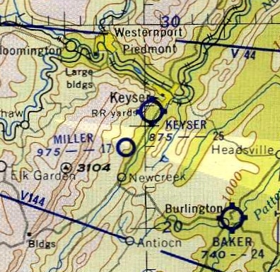
The last depiction which has been located of Keyser Airport
was on the 1954 Huntington Sectional Chart (courtesy of Chris Kennedy).
It depicted Keyser as having a 2,500' unpaved runway.
Keyser Airport was evidently closed (for reasons unknown) at some point between 1954-62,
as it was no longer depicted on the July 1962 Huntington Sectional Chart (courtesy of David Stevenson).
According to Rick Harshbarger, “My sister bought a house on a hill overlooking the former airport [in 1970]
and there were no planes there then & many of the houses in the 'Airport Addition' were already built.”
The 1972 USGS topo map continued to depict Keyser Airport as an irregularly-shaped outline, labeled simply as “Landing Field”.
The 1976 USGS topo map depicted streets & houses covering the site of Keyser Airport.
Rick Harshbarger reported in 2013, “The main hangar was used as a clothing factory for decades.”
Broadus Bowman reported in 2013, “Bill Pancake tells me when I drive up to the fire hall for the BHS Alumni Banquet I drove across the old runway!”
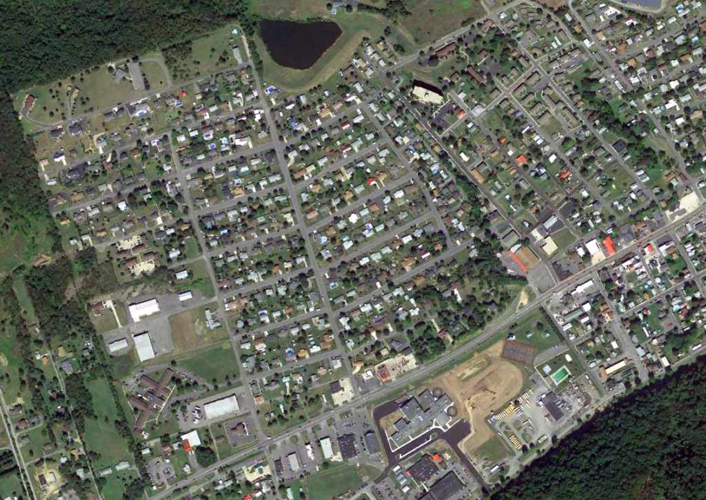
A 9/5/13 aerial photo showed houses covering the site of Keyser Airport.
However, according to Rick Harshbarger, the light-colored building at the bottom-left is the former main hangar.
The site of Keyser Airport is located at the intersection of Beacon Street & Airport Street,
appropriately enough.
____________________________________________________
Rexroad Airfield (1st location), Peeltree, WV
39.16. -80.17 (Northwest of Washington, DC)

The 1981 USGS topo map depicted the 1st location of the Rexroad Airfield simply as “Airstrip”, but curiously did not depict a runway.
Photo of the airfield while in use has not been located.
This private airfield was evidently established at some point between 1977-81,
as it was not yet depicted on the 1977 USGS topo map.
The earliest depiction of the Rexroad Airfield which has been located was on the 1981 USGS topo map.
Curiously, it labeled the site as “Airstrip”, but did not actually depict a runway.

The last depiction which has been located of the original Rexroad Airfield was on the 1988 USGS topo map.
At some point between 1988-97 the original location of the Rexroad Airfield was evidently replaced by a new location 2 miles to the southwest,
as the 1997 USGS aerial photo did not depict any trace of an airfield at the original location.
It appeared as if the original location had been replaced by strip mines.
The site of the original Rexroad Airfield is located west of the intersection of Route 57 & Isaac S Run.
____________________________________________________
Rexroad Airfield (2nd location), Peeltree, WV
39.14, -80.21 (Northwest of Washington, DC)

The 1997 USGS aerial photo depicted the 2nd location of the Rexroad Airfield as having a single east/west paved runway,
with a hangar on the south side.
Photo of the airfield while in use has not been located.
At some point between 1988-97 the original location of the Rexroad Airfield (2 miles northeast)
was evidently replaced by a new location.
The earliest depiction which has been located of the 2nd site of this airfield was the 1997 aerial photo.
It depicted Rexroad as having a single east/west paved runway, with a hangar on the south side.

The earliest aeronautical chart depiction which has been located of the Rexroad Airfield was on the July 2001 Cincinnati Sectional Chart (courtesy of Rick Harshbarger).
It depicted Rexroad as a private airfield having a single east/west 3,900' paved runway.
The last aeronautical chart depiction which has been located of the Rexroad Airfield was on the July 2004 Cincinnati Sectional Chart.
It depicted Rexroad as a private airfield having a single east/west 3,900' paved runway.

The Rexroad Airfield was evidently closed (for reasons unknown) at some point between 2004-2007,
as an August 2007 aerial view looking northwest at the Rexroad Airfield showed the runway marked with a closed “X” symbol at each end.
The hangar appeared to have a checkerboard roof.
The Rexroad Airfield was depicted as an abandoned airfield on the July 2008 Cincinnati Sectional Chart.
The site of the 2nd location of Rexroad Airfield is located north of the intersection of Route 20 & Arnolds Run.
____________________________________________________
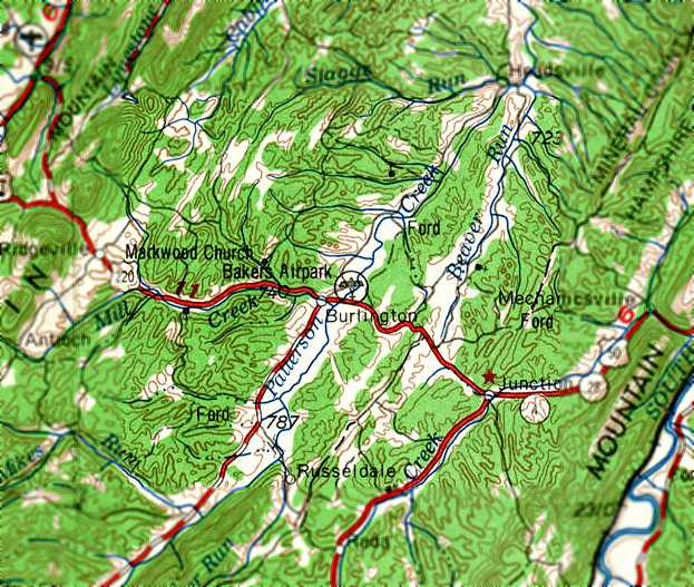
Burlington Airport / Baker Air Park, Burlington, WV
39.34, -78.91 (Northwest of Washington, DC)

The Burlington Airport, as depicted on the 1944 Huntington Sectional Chart (courtesy of Chris Kennedy).
This small general aviation airport was located in the small community of Burlington.
The date of establishment of the Burlington Airport has not been determined.
According to Bo Bowman, “The Burlington Airport probably opened in the late 1930s.
The owner was Dave Baker. Also had Baker's Drive-in Theater & Baker's Snack Bar restaurant across the highway.”
The earliest reference to the Burlington Airport comes from Robert Mitchell,
who recalled, “From 1938-42 we were at Keyser & I remember seeing my very first airplane at the Burlington Airport.
It was a bright yellow Piper Cub.
The airport was sod & was located on the north side of US 50 just beyond an old hotel that had a pet deer.”
The earliest depiction of the Burlington Airport which has been located
was on the 1944 Huntington Sectional Chart (courtesy of Chris Kennedy).
The April 1944 US Army/Navy Directory of Airfields (courtesy of Ken Mercer)
described Burlington Airport as having a 2,000' unpaved runway.

A circa 1943-45 aerial view looking north from the 1945 AAF Airfield Directory (courtesy of Scott Murdock)
depicted Burlington Airport as having a single northeast/southwest grass runway.
A single light plane was visible at the southwest corner.
The 1945 AAF Airfield Directory (courtesy of Scott Murdock) described Burlington Airport
as a 30 acre irregularly-shaped property within which were 2 sod runways, measuring 1,850' ENE/WSW & 1,000' NNE/SSW.
The field was said to have a single 46' x 40' metal & wood hangar,
and to be privately owned & operated.
According to Bo Bowman, “A 1945 Airport Directory described it as having a sod east/west 2,200’ x 500’ runway.
One interesting fact recalled is that a German Messerschmidt from WWII
was obtained & shipped to this airport by a local Army Air Corps man.
The plane was restored, painted a bright red,
and was sometimes flown on weekends for the local airport spectators’ enjoyment.”
A 1947 aerial photo showed Burlington Airport as having a single east/west grass runway,
with 2 or 3 light planes parked near a few small buildings on the southwest side.
At some point between 1944-54 the official name of the airport had changed to “Baker”,
that is how it was labeled on the 1948 Huntington Sectional Chart.
It depicted Baker as having a 2,400' unpaved runway.

A still image of the “Baker Air Park” hangar from a 16mm film taken on 9/11/49 (courtesy of Bo Boman).
The boy with the sailor hat in the foreground is Bo Bowman, with his younger cousin Paul leading him to the hangar.
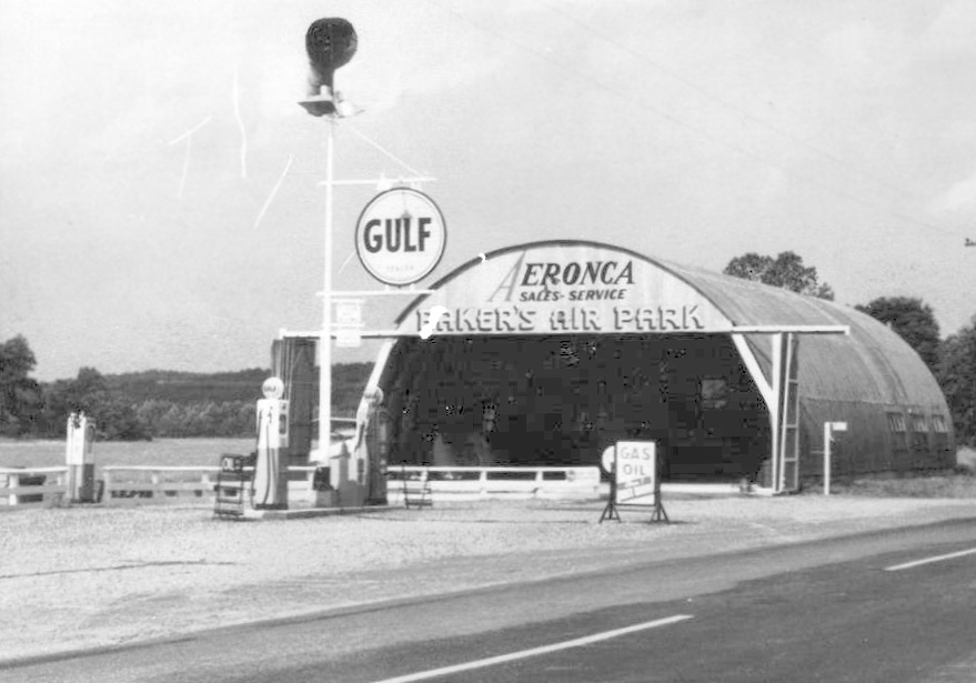
A circa 1940s picture of the same Baker's Air Park hangar (courtesy of Rick Harshbarger).
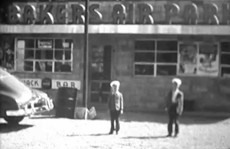
A still image of Bo Bowman & his cousin Paul in front of the “Bakers Air Park” snackbar from a 16mm film taken on 9/11/49 (courtesy of Rick Harshbarger).
According to Rick, “It was quite a lively place according my Dad whose hunting camp was just over the ridge from the airfield, especially on the weekends.”
According to Bo Bowman, “This airport was a typical small-town country airport,
offering passenger rides primarily on weekends.
The aircraft used for this purpose in the late 1940s were 2 Aeronca Champs.
The airport was owned & operated by David Baker.
This is where flying began for me at the age of about 8.
I have lots of memories from there.
Dave Baker took me for my first airplane ride in an Aeronca Champ - both my Mother & I in one seat.”

The 1954 Huntington Sectional Chart (courtesy of Chris Kennedy)
depicted Baker as having a 2,400' unpaved runway.

A still image from a Summer 1956 movie of the pretty red Messerschmidt Me108 in front of the “Baker's Air Park” hangar (courtesy of Rick Harshbarger).
According to Rick Harshbarger, “My Dad knew the guy with the Messerschmidt. They were both WW2 veterans.
He said he sent it back from Germany in pieces & reassembled it at Burlington.”
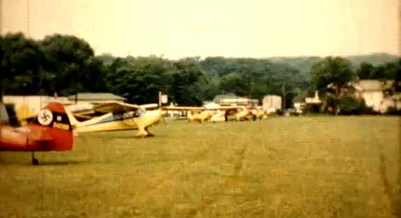
A still image from a Summer 1956 movie of the Messerschmidt Me108 & 5 other single-engine planes at Baker's Air Park (courtesy of Rick Harshbarger).

A still image from a Summer 1956 movie of a fancifully painted Mooney Mite of the Confederate Air Force at Baker's Air Park (courtesy of Rick Harshbarger).
The 1956 USGS topo map depicted it as “Bakers Airpark”.

The last aeronautical chart depiction which has been located of Baker Airpark
was on the July 1962 Huntington Sectional Chart (courtesy of David Stevenson).
It depicted Baker as having a 2,400' unpaved runway.
Rick Harshbarger recalled, “Some time in the 1960s after a snowfall of several feet,
the main hangar & perhaps more than one hangar there collapsed, destroying several planes.”
According to Bo Bowman, “The Burlington Airport probably closed in the late 1960s.”
According to Wings Over Cumberland by Bob Polling & Bill Armstrong (courtesy of Rick Harshbarger),
“Shortly after an injury to [Dave] Baker, the field ceased operations.”
Bakers Airpark was no longer depicted at all on the 1969 USGS topo map.
By the time of the 1972 USGS topo map, the Baker Air Park was no longer depicted at all,
but another (unrelated?) airfield was depicted just to the southeast on the opposite side of Route 50.

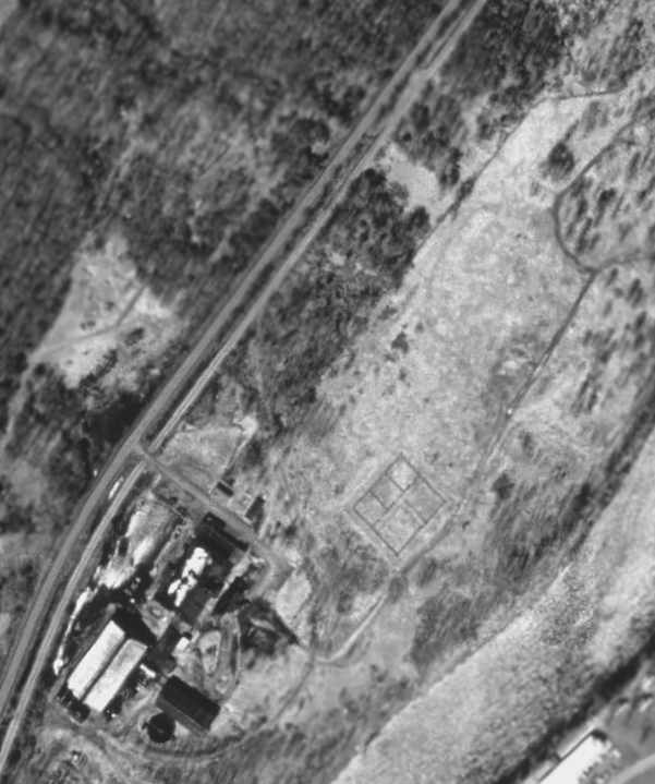
A June 2006 aerial photo by Bo Bowman looking north at the site of the former Baker Air Park.
According to Bo Bowman, “It was located parallel to & on the north side of Route 50,
bounded on the other side by the tree-lined road.”
The former airport property appears to have been reused as a highway department facility.
No trace appears to remain of the former airport.
The site of the former Baker Air Park is located on the north side of Route 50, east of its intersection with Route 11.
____________________________________________________
Dawson Army Airfield (1st location), Kingwood, WV
39.45, -79.67 (South of Pittsburgh, PA)

The original Dawson Army Airfield was depicted as an unpaved “Landing Strip”
on the northwest bank of the Cheat River on the 1960 USGS topo map.
Camp Dawson was established in 1909, when the WV State Legislature
authorized the purchase of 196 acres of land on Dunkard Bottom along the Cheat River in Preston County.
The camp was named in honor of William M. O. Dawson, a native of Preston County, who served as Governor from 1905-08.
Troops began training at Camp Dawson during the summer of 1909 and continued until the start of Word War I.
The camp was not used again until 1928 when it was reestablished as a training site for the West Virginia State Militia.
Units trained regularly at the camp until the outbreak of World War II
at which time the United States Government leased the camp for use as a Prisoner of War camp.
No airfield at Camp Dawson was yet depicted on the 1942 USGS topo map.
The original airfield for Camp Dawson was located on the northwest bank of the Cheat River.
The earliest reference to the Camp Dawson airfield came from Robert Mitchell,
who recalled, “In 1954-58 I was attached to the 249th Army Band WVNG in Fairmont.
We were attached to the local artillery unit for administrative purposes
and several times during those years we went up to Camp Dawson for rifle qualifications.
I do remember there being a small field there.
As I remember it, Dawson was a beautiful little camp.”
The earliest depiction of the Dawson airfield which has been located was on the 1960 USGS topo map,
which depicted a single 2,500' unpaved runway, labeled simply as “Landing Strip”, with one small building on the southwest side.
However, no airfield at Dawson was depicted on the 1960 or 1967 Huntington Sectional Charts (according to Chris Kennedy),
or the February 1970 Cincinnati Sectional Chart (according to Chris Kennedy).

The 1976 USGS topo map still depicted the “Landing Strip”,
however the map also depicted 2 buildings superimposed over the southwest end of the runway.
At some point between 1970-76, the original Dawson AAF
was evidently replaced by a new airfield on the opposite side of the river,
as only the field on the southeast side of the river was depicted
on the August 1976 Cincinnati Cincinnati Sectional Chart (courtesy of Chris Kennedy).
As seen in the 1997 USGS aerial photo, only the slightest trace is still recognizable of the outline of the runway of the original Dawson AAF.
The original Dawson AAF is located in between Route 72 & the Cheat River.
____________________________________________________
Since this site was first put on the web in 1999, its popularity has grown tremendously.
That has caused it to often exceed bandwidth limitations
set by the company which I pay to host it on the web.
If the total quantity of material on this site is to continue to grow,
it will require ever-increasing funding to pay its expenses.
Therefore, I request financial contributions from site visitors,
to help defray the increasing costs of the site
and ensure that it continues to be available & to grow.
What would you pay for a good aviation magazine, or a good aviation book?
Please consider a donation of an equivalent amount, at the least.
This site is not supported by commercial advertising –
it is purely supported by donations.
If you enjoy the site, and would like to make a financial contribution,
you
may use a credit card via
![]() ,
using one of 2 methods:
,
using one of 2 methods:
To make a one-time donation of an amount of your choice:
Or you can sign up for a $10 monthly subscription to help support the site on an ongoing basis:
Or if you prefer to contact me directly concerning a contribution (for a mailing address to send a check),
please contact me at: paulandterryfreeman@gmail.com
If you enjoy this web site, please support it with a financial contribution.
please contact me at: paulandterryfreeman@gmail.com
If you enjoy this web site, please support it with a financial contribution.
____________________________________________________
This site covers airfields in all 50 states.