Abandoned & Little-Known Airfields:
Southwestern West Virginia
© 2002, © 2016 by Paul Freeman. Revised 6/1/16.
This site covers airfields in all 50 states: Click here for the site's main menu.
____________________________________________________
Please consider a financial contribution to support the continued growth & operation of this site.
Bollinger Field / Hilltop Airport (revised 4/20/12) - Kanawha Seaplane Base (revised 2/11/14) - McDonald Airport (revised 12/1/14)
Rainelle Airport / Rainelle Airpark (revised 3/28/16) - Summersville Airport / (Original) Nicholas County Airport (revised 3/26/16)
Swope Farm (revised 8/25/13) - Welch Municipal Airport (revised 6/1/16) - Wertz Field (revised 9/7/11)
____________________________________________________
Rainelle Airport / Rainelle Airpark (9W4 / WV30), Rainelle, WV
37.95, -80.72 (Southwest of Washington, DC)
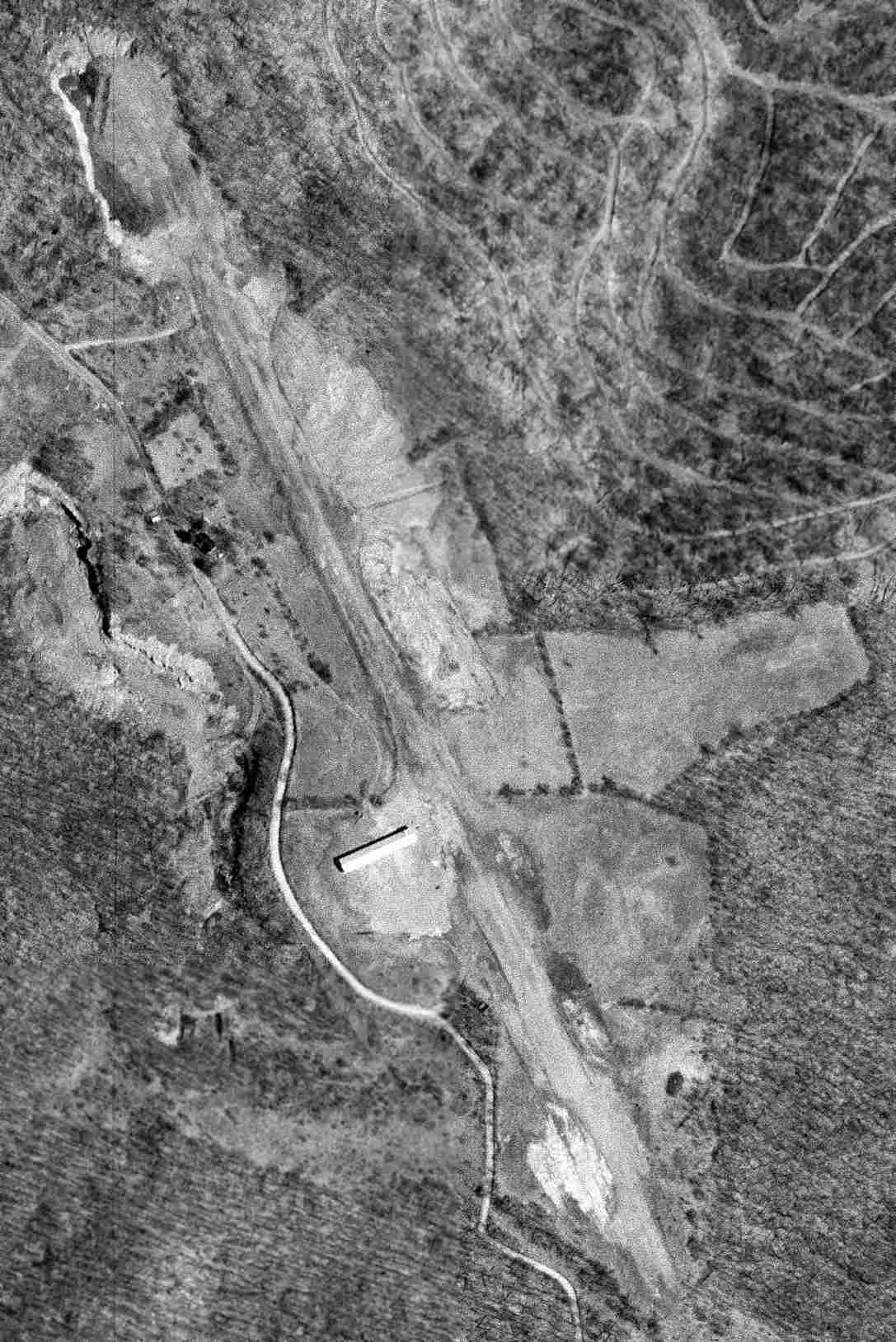
A 4/16/70 USGS aerial view depicted Rainelle Airport as having a single unpaved northwest/southeast runway & 1 hangar on the west side.
According to an article entitled “Shangri-La: An Airport to Call My Own” by Stephen Coonts in the September 1997 AOPA Pilot,
“Lawrence 'Squire' Haynes had the dream long before I did, and he did something about it.
Haynes & 2 other airplane owners decided to finance a strip on the Haynes family farm.
In 1963 he bulldozed out a 3,500' runway on an abandoned strip mine near Rainelle, rolled it hard, and sowed grass.”
However, Rainelle Airport was not yet depicted on the 1966 USGS topo map.
Rainelle Airport's FAA Airport/Facility Directory data gives an Activation Date of December 1969.
The earliest depiction which has been located of Rainelle Airport was a 4/16/70 USGS aerial view.
It depicted Rainelle Airport as having a single unpaved northwest/southeast runway & 1 hangar on the west side.
There were no aircraft visible on the field.

The 1972 USGS topo map depicted Rainelle Airpark as having a single northwest/southeast runway & 2 small buildings on the west side.
Rainelle Airport's FAA Airport/Facility Directory data described it as conducting an average of 74 takeoffs or landings per year as of 1987.

The earliest photo which has been located showing an aircraft at Rainelle Airport was an undated photo of a Mooney in front of the Rainelle Airport Restaurant
from an article entitled “Rainelle Airport & Restaurant is 'Good Plane Fare'!” in the 5/25/93 Mountain Messenger (courtesy of Rick Harshbarger).
In the article, Squire Haynes described that out of the original group that built the airport,
“I'm the president of the corporation. Most of the others have passed away.”
He described the new airport restaurant as his latest venture.
According to an article entitled “Shangri-La: An Airport to Call My Own” by Stephen Coonts in the September 1997 AOPA Pilot,
“Beside the runway he built a small cinder block restaurant, which is open on Fridays, Saturdays, and Sundays, May through October.
There is no gasoline for sale at the field.
At the restaurant beside his mountaintop airfield, Squire plays host with infectious enthusiasm,
greeting customers & talking flying, airplanes, and any other subject that comes up.
He is a spry, trim 80 years old & has no trouble scrambling up on a wing to look into a cockpit.
He has a full head of gray hair, a ready smile, and a firm handshake.
One of the reasons he is in such good shape is that he takes care of the airport himself.
He mows the runway every other week.”
Coonts continued, “The Rainelle runway is wide & rolls a little, as most grass strips do.”
"We have the reputation as the best grass strip in the state," Squire bragged.
"The wind up here can be a little tricky, though." His tanned face lit up in a smile; tricky crosswinds are one of life's good things.
Coonts continued, “I landed at Rainelle for coffee and blackberry pie on a Sunday in August,
which was one of those rare perfect days: scattered clouds with bases around 4,500'; almost no wind;
visibility 10 miles in haze; temperatures in the 70s; and a soft, gauzy sun that made everything glow.
It was a sublime, gentle day, a day made for flying.
A dozen people sat in front of the restaurant, behind 3 parked airplanes.
They had just finished the Sunday buffet.”
"People drive or fly in to eat & visit and shoot the bull," Haynes said grandly, then undertook to introduce me to everyone.
"The hottest airplane we ever had land here was a P-51 Mustang," Haynes told me. "Boy, that was a day."
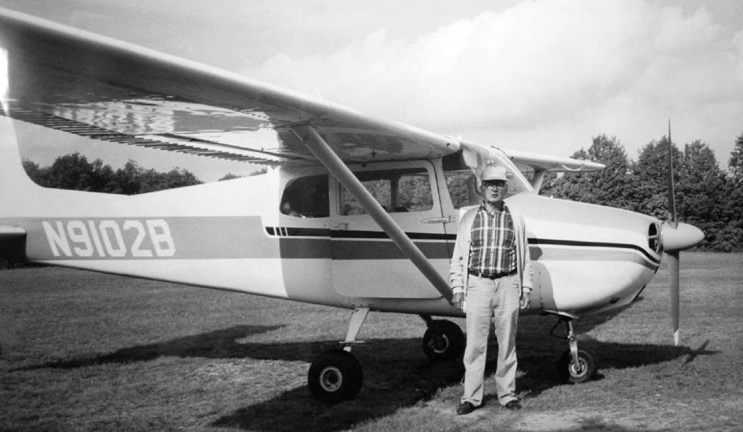
An undated photo of Squire Haynes in front of a Cessna 172 at at Rainelle Airport (courtesy of Rick Harshbarger).
Herbert Shuck recalled, “I helped Squire with mowing & maintenance while he was still running the restaurant”
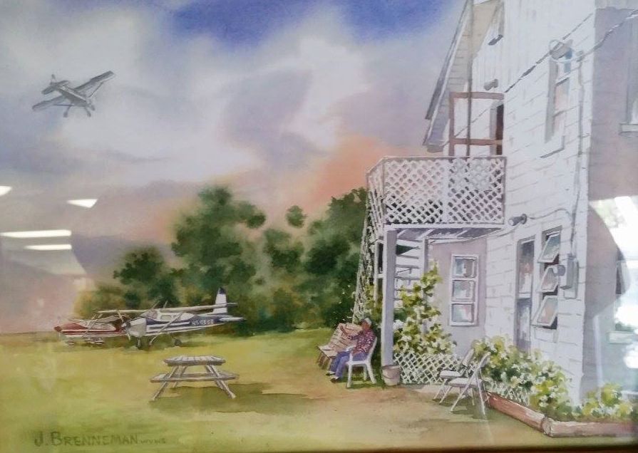
An undated painting by Jeanne Brenneman of Squire Haynes watching planes from in front of the Rainelle Airport Restaurant (courtesy of Rick Harshbarger).

A 1997 aerial view by Ernie Clay looking north at Rainelle (courtesy of Rick Harshbarger).
Ernie recalled, “In 1997, we hosted the International Cessna 120/140 Association Convention at Ona Airport.
We flew from Ona to Rainelle with me leading & Bo Mabry as 'Tail-end-Charlie' bringing up the end of the 58 plane flight for the always-great buffet.”

An undated aerial view looking northwest at Rainelle Airport (purchased in 2002 by Rick Harshbarger from Squire Haynes)
depicted 10 light aircraft parked on either side of the grass runway near the hangar/restaurant.

An 8/15/02 photo of a Cessna 185F (“Linda”) at Rainelle Airport.
A 2003 aerial photo showed that land had been cleared for a 2nd hangar, on the northeast side of the Rainelle runway.
Rainelle Airport founder Squire Haynes passed away in 2005.
Herbert Shuck reported, “There are about 14 people who purchased land surrounding the runway, myself included. It was intended to be maintained as an air-park.
Ralph Williams was secretary for the corporation & managed it for Squire's sister after Squire passed away.”
A 2007 aerial photo showed that a 2nd hangar had been built on the northeast side of the Rainelle runway,
and land had been cleared for a 3rd hangar, on the southwest side of the Rainelle runway.
A 2009 aerial photo showed that a 3rd hangar had been built on the southwest side of the Rainelle runway.

A circa 2010 aerial view looking west at Rainelle Airport was an undated aerial view looking northwest (purchased in 2002 by Rick Harshbarger from Squire Haines)
which depicted 10 light aircraft parked on either side of the grass runway near the hangar/restaurant.

A 6/4/10 photo looking along Rainelle Airport's grass runway.
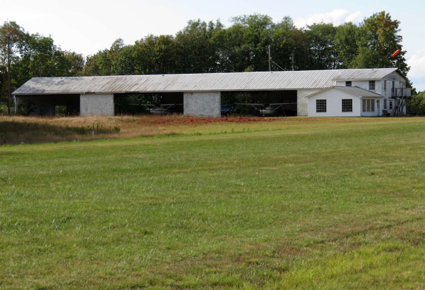
A 9/9/12 photo by Herbert Shuck looking northwest at Rainelle Airport's hangar & restaurant, showing 2 Cessna 152s inside the hangar.

A 9/9/12 photo by Herbert Shuck looking along Rainelle Airport's pretty grass runway.

A 2013 aerial view looking northwest showed Rainelle Airport to have a total of 3 hangars along its grass runway.

A 9/2/13 photo by Michael Sheridan looking along the Rainelle Airport runway, with the restaurant & windsock at left (courtesy of Rick Harshbarger).
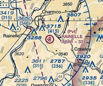
The 2014 Sectional Chart depicted Rainelle as a private airfield having a 3,300' unpaved runway.
As of 2014, Rainelle Airport's FAA Airport/Facility Directory data described it as having a single 3,300' turf Runway 17/35,
listed the owner as Rainelle Airpark Inc., and the manager as Ralph Williams.
It was said to have only a single based aircraft.
Rich Harshbarger reported in 2014, “The beautiful Rainelle Airport... It's all but closed.
I landed there with my friend this summer, there was no one there but a few planes still in hangars.
Long & smooth with open approaches. The restaurant is abandoned & most of the hangars empty.
If you call the airport manager's phone number & ask about the airport, the secretary will tell you it's closed.”
Rick also reported that the newest hangar, on the southwest side of the Rainelle runway,
“That's a house & a hangar... We were told the guy was able to buy the lot adjoining the runway but not the runway.
He does not own a plane & the hangar was piled full of everything but a plane.
It's a big house and we were also told that the guy that owns the house also mows & rolls the runway for fun...
he enjoys it & he is retired of course.”

A 3/1/14 photo by Ralph Young of 3 beautiful Piper Cubs in front of the Rainelle Airport Restaurant (courtesy of Rick Harshbarger).
Herbert Suck reported in 2015, “There is no new owner, other than a gentleman who purchased the Haynes' shares of the corporation.
Heirs of other original members hold shares & they do not want to maintain it as an airport.
However landowner deeds say it will remain as such & are guaranteed access to it.
There have been attempts to purchase the remaining shares, but the shareholders are either not organized in their effort or are not in agreement as to how to proceed with the matter.
I have been keeping it mowed since [the restaurant closed].
I am doing it at my own expense for myself & other landowners who choose to use it. I have a little help at times from a couple of the other landowners.
I cannot guarantee that it is suitable for landing at all times. Pilots are responsible for checking on conditions.
Squire's dream has not materialized. It is the hope of many that someone can purchase the airport & restore it to the place that Squire loved so passionately.”
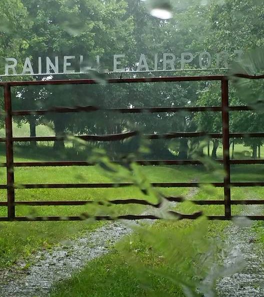
A 7/2/15 photo by Tina Legg of the Rainelle Airport gate.
Rainelle Airport is located northeast of the intersection of Route 60 & Airport Road, appropriately enough.
Thanks to Rick Harshbarger for pointing out this airfield.
____________________________________________________
Summersville Airport / (Original) Nicholas County Airport, Summersville, WV
38.33, -80.83 (West of Washington, DC)
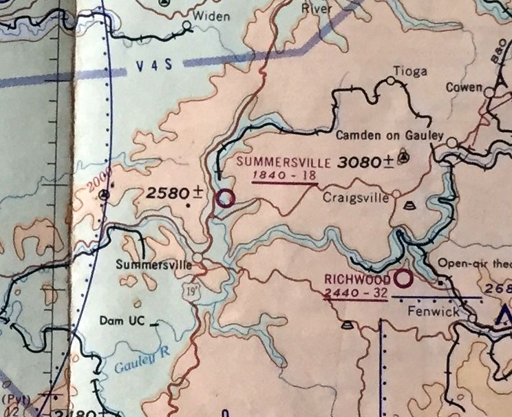
Summersville Airport, as depicted on the July 1962 Huntington Sectional Chart (courtesy of David Stevenson).
According to Rick Harshbarger, the original Nicholas County Airport was located on the north side of Summersville.
No airfield at this location was depicted on the 1949 USGS topo map.
According to Rick Harshbarger, the original Nicholas County Airport
was operated by the same Rader Flying Service which operates the current-day Nicholas County Airport.
Rick reported, “I talked to Buck Hamrick who is a pilot. The Nicholas County Airport... was started by Gerald Rader of Rader Aviation around 1950.
The old airport was grass & measured 2,250' x 100'. Mr. Hamrick flew in & out of there with his father as a small child & continued flying there until it closed.”
The earliest depiction which has been located of Summersville Airport was on the July 1962 Huntington Sectional Chart (courtesy of David Stevenson).
It depicted Summersville as having an 1,800' unpaved runway.
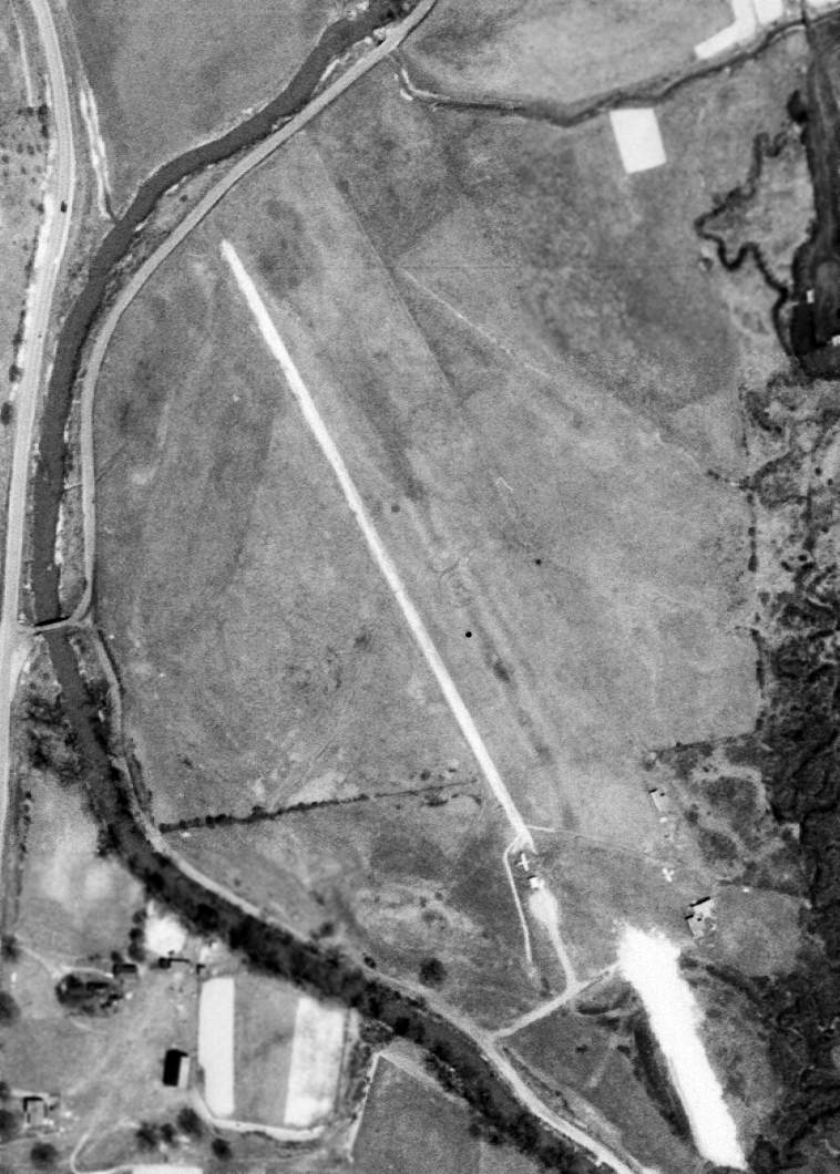
The only photo which has been located showing the original Nicholas County Airport in operation was a 4/26/63 USGS aerial view,
which depicted the field as having a single unpaved northwest/southeast runway,
with 2 single-engine planes & several T-hangars on the southeast side.
No airfield at this location was depicted on the 1968 USGS topo map.
According to Rick Harshbarger, “The Nicholas County Airport... was in operation until 1968 or 69 when the Army Corps of Engineers
while building the Summersville Dam leveled off the top of a peninsula that stuck out into the lake.
Mr. Rader convinced them & the local government to make it the new municipal airport.”

A 9/5/13 aerial view of the site of the original Nicholas County Airport showed the 600' portion used by a remote-controlled model aircraft club.

A 2014 photo by Rick Harshbarger of a derelict Cessna Skymaster (lacking both front & rear propellers)
at the site of the original Nicholas County Airport.

A 2014 photo by Rick Harshbarger of Butler Field, Home of Wally's Squadron Remote Control Flyers club,
which has a 600' grass strip & an office trailer at the site of the original Nicholas County Airport.

A 2014 photo by Rick Harshbarger of the sign for Old Airport Road,
with the former airfield of the original Nicholas County Airport in the background.
The site of the original Nicholas County Airport is located northwest of the intersection of Lower Glade Fork & Old Airport Road,
appropriately enough.
Thanks to Rick Harshbarger for pointing out this airfield.
____________________________________________________
Kanawha Seaplane Base, Charleston, WV
38.35 North / 81.63 West (West of Washington, DC)
A 1938 photo (courtesy of www.mywvhome.com) of 20 year old Boyd Wolfe & another pilot (both wearing parachutes) in front of 2 Aeronca Champ floatplanes at Kanawha.
According to Mark Hess, the “Kanawha Seaplane Base... opened sometime after 1937, owned by Glenn Clark.”
The earliest depiction which has been located of Kanawha Seaplane Base
was a 1938 photo (courtesy of Mark Hess) of 20 year old Boyd Wolfe & another pilot (both wearing parachutes) in front of 2 Aeronca Champ floatplanes at Kanawha.
According to Mark Hess, the “Kanawha Seaplane Base... was called Charleston #2 Squadron of the Civil Air Patrol during WWII.
Clark ran this operation. It was also a Civilian Pilot Training Program base.”

A 1940 photo (courtesy of www.mywvhome.com) of the Kanawha Seaplane Base at its original location on the northeast bank of the river, with 3 Aeronca Champ floatplanes at the bottom-right.

A 1942 photo (courtesy of www.mywvhome.com) of the Kanawha Seaplane Base, after Clark had moved the base across the river to the southwest bank.
One floatplane is visible at bottom-right, and note the "Kanawha Flying School" on the building above it.

A 2014 photo by Sandi Galloway of an undated patch for the "Kanawha Flying School".
Sandi noted, “My husband Perry learned to fly it at the Kanawha Flying School.”
A 1944 map (courtesy of Mark Hess) depicted Kanawha “Sea Plane Base” at the lower left.

The only aeronautical chart depiction which has been located of the Kanawha Seaplane Base
was on the November 1945 Huntington Sectional Chart (courtesy of Chris Kennedy).
According to Mike Riley, this chart “shows Clark's base after he moved it from the Charleston levee
west to a location near the town of Winfield [labeled as “Clark” at the top-left].
The seaplane base in Charleston stayed open a little longer after Clark sold it.”
According to Mark Hess, the “Kanawha Seaplane Base... closed sometime in the late 1940s.
The Kanawha Seaplane Base was no longer depicted on the 1954 Huntington Sectional Chart.
As of 2012, no trace remains of the Kanawha Seaplan Base.
The site of the Kanawha Seaplane Base is located south the intersection of Summers Street & Kanawha Boulevard.
____________________________________________________
Welch Municipal Airport (I25), Welch, WV
37.42, -81.53 (Southwest of Charleston, WV)

Welch Municipal Airport, as depicted on the 1955 USGS topo map.
According to its FAA Airport/Facility Directory Data, Welch Municipal Airport was established in August 1947.
The earliest depiction of Welch Municipal Airport which has been located was on the on the 1955 USGS topo map.

A circa 1950s/60s photo of the sign for Welch Airport (courtesy of Rick Harshbarger), with a curved-roof hangar in the background.

A circa 1950s/60s photo of an Ercoupe inside the curved-roof hangar at Welch Airport (courtesy of Rick Harshbarger).
The 1968 USGS topo map depicted Welch Municipal Airport as having 2 very closely-angled runways,
and a few small buildings on the northeast & southeast sides.

The earliest photo which has been located of Welch Municipal Airport was a 4/26/94 USGS aerial view looking west,
several small buildings on the northeast & southeast sides, and what appeared to be one light aircraft.

The last photo which has been located showing an aircraft at Welch Municipal Airport was a 1/1/03 aerial view looking west,
showing one single-engine aircraft on the northeast ramp.
Runway 27 actually had a bend in the middle, following the alignment of 2 individual runways depicted on the 1968 topo map.
According to Bob Aberman, “Welch Airport was closed in 2006.”
An 8/25/07 aerial view showed closed-runway “X” symbols painted on Welch's runway,
and the hangars on the southeast side had been removed at some point between 2003-2007.

A 7/10/11 aerial view looking west showed the runway to remain intact, though marked with a closed-runway “X” symbol.
The hangar on the northeast side remained standing.

The 2011 USGS topo map continued to depict Welch Municipal Airport, with a bend in its runway.
As of 2012, the FAA Airport/Facility Directory Data described Welch Municipal Airport as having a single 2,695' asphalt Runway 9/27,
“in poor condition, pavement condition failed, surface rough & cracking”,
and the first 300' of Runway 27 were noted to have a “3 degree bend”,
with “No line of sight between runway ends.”
It was said to be owned by the City of Welch, with the manager listed as Robert Lee.
The airport was said to have 2 single-engine based aircraft,
and to conduct an average of only 65 takeoffs or landings per year.
Although Welch continued to be listed in the A/FD, its airport status was listed as “Airport closed indefinitely.”
Bob Aberman reported in 2012, “Welch Airport.. a few people fly [radio-controlled model aircraft] there.”

A July 2013 photo by Randy Coller of the entrance sign & hangar at Welch Airport.

A July 2013 photo by Randy Coller of the Welch Airport hangar, with the wind sock frame on the roof.

A July 2013 photo by Randy Coller of the remains of the Welch Airport runway.
Randy reported in 2016, “I’ve inspected Welch a few times. It’s a real mess. I would not land a plane there.
Sometimes there are picnic tables & barrels on the runway. The trees have overgrown the edges.
I talked to the Mayor a few years ago, and they have hopes of maybe re-opening it someday,
perhaps when the economy in the area improves or someone with a pile of money walks in the door to help them.
'Closed' in FAA terms generally is a temporary status.
'Abandoned' is permanent, the airspace it given up & the airport would not be re-opened again.
I normally would press the airport owner to abandon the site,
but it is so hard to get a favorable airspace determination from the FAA to open an airport, that I didn’t press the city to go the abandonment route.”
Welch Municipal Airport is located at the southern terminus of County Road 52/16.
____________________________________________________
Bollinger Field / Hilltop Airport, Ruth, WV
38.32 North / 81.72 West (Southwest of Charleston, WV)
Bollinger Field, as depicted on the November 1945 Huntington Sectional Chart (courtesy of Chris Kennedy).
This little general aviation airport was located in the hills of WV.
According to Jerry Waters, Bollinger Field “opened in the 1930s I believe.”
However, Bollinger Field was not listed among active airfields in the Airport Directory Company's Airport Directories from 1933, 1938, or 1941
or the 1945 AAF Airfield Directory (courtesy of Scott Murdock),
and it was not depicted on the May 1945 Huntington Sectional Chart (according to Chris Kennedy).
The earliest depiction of Bollinger Field which has been located
was on the on the November 1945 Huntington Sectional Chart (courtesy of Chris Kennedy).
It depicted Bollinger as having a commercial/municipal airport.
According to Mark Hess, Bollinger Field was “owned by Cramer Bollinger.
Bollinger took hundreds of aerial movies during this time.”
The Haire Publishing Company's 1945 Airport Directory (courtesy of Chris Kennedy)
described Bollinger Airport as a “Class 1” airport, owned & operated by Charleston Aviation Corporation.
The manager was listed as C.G. Bollinger.
The field was said to consist of 92 acres, irregularly-shaped,
within which was a single 2,200' sod east/west runway, and 2 hangars.

A 1946 photo of a Stinson V77 Reliant of All American Airways
picking up mail at Bollinger Field (from the Benny Mallory collection, courtesy of www.mywvhome.com).
A wire was stretched between 2 poles & a hook on the aircraft snatched up the mail bag!

A 1946 advertisement (courtesy of Mark Hess) for the “Just opened, new, modern GI School” at Bollinger Airport.
A 1946 newspaper article (courtesy of Mark Hess) proclaimed that 2 Sikorsky R-5 helicopters would be on display at Bollinger Airport,
as they had “been purchased by the Atlantic Greyhound Lines for experimental purposes pending the start of a feeder service throughout the nation.”

From a 7/21/46 article (courtesy of Mark Hess), a photo of “Ex-servicemen attend GI Flying School at Bollinger Airport” in front of an Aeronca.

An undated aerial view of Bollinger Field (from the Benny Mallory collection, courtesy of www.mywvhome.com),
showing at least 5 aircraft on the field, with the hangar on the right-rear.
The May 1957 Huntington Sectional Chart (according to Chris Kennedy)
described Bollinger Field as having a 2,100' unpaved runway.
At some point between 1957-58, Bollinger Field was evidently renamed Hilltop Airport & had its runway lengthened,
as the May 1958 Huntington Sectional Chart (courtesy of Chris Kennedy)
labeled the field as Hilltop & depicted it as having a 3,600' unpaved runway.

The 1958 USGS topo map depicted “Hill Top Airport (Private)” as having a single unpaved northwest/southeast runway,
with a few small buildings on the north side.
According to Jerry Waters, “I'm not sure when Bollinger closed. I've heard in the 1960s.”
Bollinger/Hilltop Field was evidently closed (for reasons unknown) by 1961,
as it was no longer depicted on the June 1961 Kahawha River World Aeronautical Chart (according to Chris Kennedy),
or the 1965 USGS topo map.
The 1996 USGS aerial photo showed that several large buildings had been constructed over the site of Bollinger Field,
with no trace remaining of the former airport.
The site of Bollinger Airport is located northeast of the intersection of Route 119 & Southridge Boulevard.
____________________________________________________
37.75 North / 81.9 West (Southwest of Charleston, WV)

McDonald Airport, as depicted on the October 1948 Winston-Salem Sectional Chart (courtesy of Chris Kennedy).
This unusual little airport was located on a narrow slice of land on the south bank of the Guyandotte River,
with the grass runway following the curve of the riverbank.
McDonald Airport was evidently established at some point between 1945-48,
as it was not yet depicted at all on the March 1945 Winston-Salem Sectional Chart (according to Chris Kennedy)
nor listed among active airfields in the 1945 AAF Airfield Directory (courtesy of Scott Murdock).
The earliest depiction of the field which has been located
was on the on the October 1948 Winston-Salem Sectional Chart (courtesy of Chris Kennedy).
It depicted McDonald Airport as having a 2,500' unpaved runway.
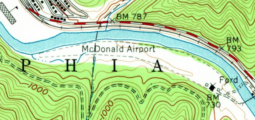
The 1963 USGS topo map depicted McDonald Airport as having a single 2,600' unpaved runway (somewhat curved, following the riverbank).
Three small buildings (hangars?) were depicted southeast of the runway.
Don Elmore recalled, “I have been into the McDonald Airport several times.
Charlie Belcher flew for Buck Harless, a WV coal & timber magnate.
Cotton McGlothlin was the chief pilot at the time & they operated a King Air in & out of McDonald many times.”
According to Bill Napier, “McDonald Field Airport was near my home town, Logan, WV.
I have never been on the field, but have driven past it & flew over it.
I was never able to really make it out from the air. It was definitely from another era.
When I found it on sectionals in the late 1980s it was marked as 'Hazardous.'
I can assure you it was. But that was another era.”

The 1989 USGS topo map depicted “McDonald Field” as having a single 2,600' unpaved runway (somewhat curved, following the riverbank).
Two small buildings (hangars?) were depicted southeast of the runway.

The 4/24/96 USGS aerial photo showed that the runway remained clear at McDonald Airport,
along with the cluster of small buildings on the southeast side of the field.
However, there were no planes visible on the field.
Eddie Shields recalled, “My wife & I visited it about 1999 just before they plowed it up & closed it for good.
You had to walk over a swinging bridge to get to it.”
A 2003 aerial photo showed that most of the hangars & buildings had been removed at some point between 1996-2003.

The last aeronautical chart depiction which has been located of McDonald Airport
was on the December 2003 Cincinnati Sectional Chart (courtesy of Chris Kennedy).
It depicted McDonald as a private field with a 2,700' unpaved runway,
which was noted as being “Hazardous”.
McDonald Airport was evidently closed at some point between 2003-2006,
as it was no longer listed among active airfields in the FAA Airport/Facility Directory data as of January 2006.

A pre-2006 photo looking east at the tiny grass clearing which is McDonald Field (courtesy of Bill Napier).

A pre-2006 photo of a hangar which remained at McDonald Field (courtesy of Bill Napier).
Bill Napier passed along an observation in 2006: “I took another trip to the Taplin Airport one day.
The bridge was closed to traffic, although there is a small pedestrian door.
My brother & I walked out to the middle of the bridge, since I had never crossed a swinging bridge I was kind of hesitant.
The bridge floor is in good condition & the cables holding it look strong, but half way was all I would travel!
Some of the neighbors around the bridge told us, rumor was,
that they were going to tear down the hangars at the field,
so my brother took me down to the Rich Creek bridge & around the mountain to the airfield.
I took several more pictures of the hangars.
I did find where the official name for the airstrip was McDonald Field Airport
and that it was last inspected in 1996.
The sad thing is, what stories such a place could hold,
and as far as I could determine, there are no written record of it.”
A 5/9/07 aerial photo showed that a new road had been cut through the southern portion of the airfield site at some point between 2003-2007.

A 6/8/09 aerial view looking west along the remains of the MacDonald runway.
The site of McDonald Airport is located at the eastern terminus of Taplin Airport Road,
appropriately enough.
____________________________________________________
38.38 North / 81.78 West (West of Roanoke, VA)
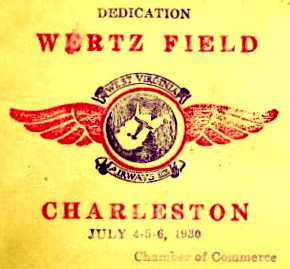
A postmark commemorating the July 4-6, 1930 dedication of Wertz Field.
In 1929 the City of Charleston purchased property for its original airport in the town of Institute (6 miles west of Charleston),
as described on the present-day Charleston Yeager Airport's web site (courtesy of Bob Merritt).
The new field was to be named Wertz Field.
By 1930 the City of Charles still lacked the funds to develop & operate a new airport,
so it leased the tract to a group of businessmen who formed West Virginia Airways, Inc.,
which eventually was able to provide aviation facilities at the site for the next 12 years.
Wertz Field was dedicated on July 4-6, 1930.
Later, with help of federal funds, a large administration building was completed.
Gary Gowans reported, “My father-in-law was 16 years old he took about 30 pictures from Wertz Field on 6/14/31.
Included are pictures of Wiley Post’s plane 9 days before his around-the-world takeoff.
Also Goodyear blimp Columbia NA-11A which only existed for about 7 months, as well as a gyrocopter, and a number of biplanes.”
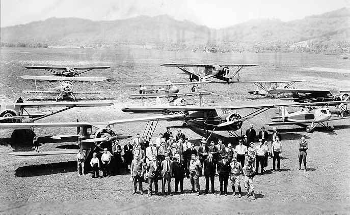
The earliest photo which has been located of Wertz Field
was a 5/16/32 photo of several biplanes & monoplanes at Wertz Field (courtesy of www.mywvhome.com).

A 1932 photo of a several Army Curtiss A-3 biplanes in front of the Wertz Field hangar (courtesy of www.mywvhome.com).
By 1933 West Virginia was up to that time was one of but 2 states which did not have air mail services.
In October, American Airlines was awarded an air mail contract route,
and opened passenger service between Washington & Chicago, via Charleston,
serving intermediate cities of Elkins, Huntington, Cincinnati, and Indianapolis.
The earliest directory reference to Wertz Field which has been located
was in The Airport Directory Company's 1933 Airports Directory (according to Chris Kennedy).
It described Wertz Field as a 160-acre rectangular property,
having 2 sod runways - 2,500' east/west & 1,600' north/south.
A hangar was said to have "Charleston" & "Wertz Field" painted on the roof.
Wertz Field was not yet depicted on the 1933 USGS topo map.
Wertz Field was described in the same fashion in the
1934 Department of Commerce Airport Directory (according to Chris Kennedy).

A 1934 photo (courtesy of www.mywvhome.com) of pioneering aviator Wiley Post visiting Wertz Field in his famous Lockheed Vega 5-B Winnie Mae.
Post had been the 1st person to fly around the world solo.
In 1935, Pennsylvania Central Airlines (Capital Airlines)
established a branch route passenger service between Charleston & Pittsburgh.
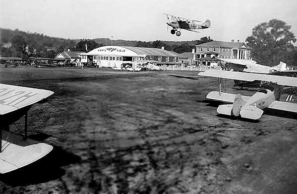
An undated (circa 1930s?) photo of a barnstorming show at Wertz Field (courtesy of Larry Anderson).
The Airport Directory Company's 1937 Airports Directory (courtesy of Bob Rambo)
described Wertz Field as a municipal airport consisting of a 160-acre rectangular sod field.
It was said to have 3 runways, with the longest being the 2,900' northeast/southwest runway.
Two of the runways were also said to have a 1,200' paved portion.
A hangar was said to have "Charleston" & "Wertz Field" painted on the roof.
By 1937, with larger passenger planes having been put into service by air carriers,
the short runways & obstructed approaches of Wertz Field began showing the field's inadequacy.
American Airlines notified City of Charleston that it would be forced to discontinue service
because Wertz Field was too limited for landing larger planes.
City's aviation enthusiasts prevailed on American Airlines to continue service, using smaller DC-2 planes.
Leaders in Charleston Chamber of Commerce realized that site for a new airport must be found.
A committee was appointed consisted of D.M. Giltinan, D.N. Mohler, D.C. Kennedy, Charles E. Hodges, Fred Alley, and J.B. Pierce.
This committee was asked to make survey of airport needs & to study all possible airport sites within 25-mile radius.
In 1938, after a year examining on foot, by car and topographical maps every possible site,
committee reported that the valley floor offered no suitable site large enough to meet area's growing needs.
Even Wertz Field did not permit expansion.
The committee decided that "We must build on the hilltops."

An undated (circa late 1930s – early 1940s?) photo of a DC-2 & two Army aircraft at Wertz Field (courtesy of Larry Anderson).

The earliest aeronautical chart depiction of Wertz Field which has been located
was on the 1939 Huntington Sectional Chart (courtesy of Chris Kennedy).
In 1940 a site for a replacement airport was suggested along a series of hills not far from Charleston's city limits.
However, work on the replacement airport was put on the 'back burner' by projects which were certified as essential to national defense.

An undated topo map depicting Wertz Field, from a 1941 Civil Aeronautics Board accident report (courtesy of Bob Merritt).
In April 16, 1941, a Boeing 247D of Pennsylvania Central Airlines crashed immediately after departure from Wertz Field.
The crash was described in a September 1941 Civil Aeronautics Board report (courtesy of Bob Merritt).
One engine had lost power, and the captain's attempt to continue the climb
was complicated by the hills & powerlines which surrounded Wertz Field.
The crash destroyed the aircraft & injured some of the crew & passengers.
The report included an undated topo map which depicted the airport.
It depicted the field as having three runways, with the longest being a 2,900' northeast/southwest strip.
An administration building was depicted as being located at the northeast corner of the field,
immediately off the end of one of the runways.
Bob Merritt observed, "The amazing thing is that the airlines were able to operate from this little airport with 2,500' runways,
down in the river bottom with surrounding hills & powerlines for 12 years with apparently no fatalities."

The last depiction of Wertz Field as an active airfield which has been located
was on a 1941 Regional Aeronautical Chart (courtesy of Chris Kennedy).
The last directory reference to Wertz Field as an active airfield which has been located
was in The Airport Directory Company's 1941 Airports Directory (according to Chris Kennedy).
Charleston lost its original airport without gaining a replacement on May 12, 1942,
when Wertz Field was closed after 12 years of operation,
as the field's property became the site of a large synthetic rubber plant for the war effort.
It took just 10 months for the employees of Ford, Bacon and Davis to build the massive plant.
Carbide & Carbon Chemicals Corporation along with U.S. Rubber undertook the project.

A July 1943 photo of an Air Corps C-47 which evidently crash landed at the former Wertz Field,
with the plant which replaced the airfield visible in the background (courtesy of Larry Anderson).
Charleston's Kanawha Airport was finally opened just north of the city in 1947,
after the City of Charleston had been without an airport for 5 years.
Wertz Field was no longer depicted on the 1954 USGS topo map.
The 1976 USGS topo map showed that the site of Wertz Field was covered by industrial facilities,
and no trace of the former airport appeared to remain.

In the 1990 USGS aerial photo, industrial facilities covered the site of former Wertz Field,
and no trace of the former airport appeared to remain.
As of 2004, the site of Wertz Field is still occupied by the Bayer CropScience Institute Site,
an agricultural chemical facility which is the descendant of the rubber plant built over the former airport site.
Thanks to Bob Merritt for pointing out this airfield.
____________________________________________________
Swope Farm (WV11), Fan Rock, WV
37.57 North / 81.62 West (West of Roanoke, VA)

The Swope Farm Airfield, as depicted on the 1996 USGS aerial photo.
This private airfield is remarkable for a short runway which is both sharply curved, and steeply sloped.
Its sole Runway 7/25 is extremely short (only 1,250'),
but also slopes sharply downhill: dropping from 1,800' elevation to 1,665' - a grade of 11%!
Avid flyer W.O. Swope purchased the land for the airfield in 1963,
and immediately began planning & construction for an extremely unusual runway,
given the very unaccommodating topography.
The hangar was originally located at the bottom of the runway.
However, it was moved to the top of the runway after an unfortunate incident
in which Swope's brakes overheated going downhill,
and he had to dump the plane in the brush to avoid hitting the hangar.
Strangely, no airfield at this location was depicted on the 1966 or 1976 USGS topo maps.
The earliest depiction which has been located of the Swope Airfield was on the 1996 USGS aerial photo.
Swope reportedly based & flew a twin-engine Beechcraft Baron (!) and a helicopter from the airfield.
He logged a total of 3,000 takeoffs & landings into the Swope Farm airfield.
Swope only had one eye.
Takeoffs were made downhill, and landings were made uphill.
The helicopter could only be landed at the very top of the runway,
as the lower portion of the runway was too steep.
According to nearby resident Mark Hrutkay, “Mr. Swope was the Mayor of Welch WV for many years
and had an early (underpowered) Bell JetRanger.
He had a landing pad on top of his building and flew it off of there.
They used to throw some really wild fly-in parties at the airport
and it would look like an aircraft carrier with all the planes crammed onto the field
(there isn't much field that isn't runway).
Mr. Swope made his last flight in & out of there 2 days before he died at age 86 [in 2001].
He was the type of pilot they don't have many of anymore.”
Swope's son reportedly planned to keep the airfield in operation.
According to Mark Hrutkay, “His son still has the Jet Ranger.”
On recent aeronautical charts, the airfield was labeled "Swope (Hazardous)".
The 1996 USGS topo map depicted the curved runway as a road, not labeled as a runway.

A pre-2005 aerial view looking east (and uphill!) at the Swope Farm Airfield.
Mark Hrutkay reported in 2006, “I love flying down the runway in my helicopters -
its a precision thing to do & its downhill.
Since Mr. Swope has died, trees have about closed in to where it is too narrow to operate from.”

A circa 2010 aerial view looking east at the Swope Farm Airfield shows this bizarre little runway to remain intact.
____________________________________________________
Since this site was first put on the web in 1999, its popularity has grown tremendously.
That has caused it to often exceed bandwidth limitations
set by the company which I pay to host it on the web.
If the total quantity of material on this site is to continue to grow,
it will require ever-increasing funding to pay its expenses.
Therefore, I request financial contributions from site visitors,
to help defray the increasing costs of the site
and ensure that it continues to be available & to grow.
What would you pay for a good aviation magazine, or a good aviation book?
Please consider a donation of an equivalent amount, at the least.
This site is not supported by commercial advertising –
it is purely supported by donations.
If you enjoy the site, and would like to make a financial contribution,
you
may use a credit card via
![]() ,
using one of 2 methods:
,
using one of 2 methods:
To make a one-time donation of an amount of your choice:
Or you can sign up for a $10 monthly subscription to help support the site on an ongoing basis:
Or if you prefer to contact me directly concerning a contribution (for a mailing address to send a check),
please contact me at: paulandterryfreeman@gmail.com
If you enjoy this web site, please support it with a financial contribution.
please contact me at: paulandterryfreeman@gmail.com
If you enjoy this web site, please support it with a financial contribution.
____________________________________________________
This site covers airfields in all 50 states.