RHUMBLINE EXPLANATION AND SIMULATIONS
Be patient! This page downloads slowly! There are charts on this page and I didn't scrunch them as that makes them hard to see.
For boats that can maintain ten knots or more in rough seas, the Gulf Streams forces are manageable. But this is not so for the small sail or power boats, which must cope with the forces of the wind, waves and the Gulf Stream. The idea is to leave from Point A and make it to Point B safely.
To help demonstrate the forces affecting a typical summer crossing, I put together three computer generated simulated crossings. All three crossings are from Port Everglades to Bimini a 47.9 NM trip at 123 degrees magnetic heading. Each crossing is under identical conditions but there are three different navigational techniques used:
-
Direct Compass heading route,
-
Compass offset route
-
Follow the GPS corrected route.
These examples are southerly against the Gulf Stream. When crossing to a northern destination, the boats average speed is increased by 2 ½ kts. Thus requiring less of a course off set from the rhumb line.
Conditions for each simulation:
- The boat used in the simulations was a 32-foot sailboat heavily loaded.
- The maximum cruise speed under engine power was 5.5 knots in smooth seas.
- Sea conditions when leaving at 4 AM from Port Everglades, 2 to 4 ft. waves and winds southeast 5 to 10 knots.
Experienced 3 to 5 waves near the mid point of crossing with winds southeast at 15 kts .After the halfway point. a line of thunderstorms beats down for two
hours.
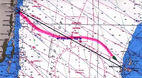
SIMULATION # 1 SET COURSE DIRECT FOR BIMINI AT 123° MAGNETIC

By not correcting for the Gulf Stream, the boat is pushed north off course. About two in the afternoon the depth finder begins working again we are in 40 Ft. of water with no sign of land. WHAT DO WE DO NOW?
SIMULATION # 2 COMPASS OFFSET ROUTE. SET AUTOPILOT TO 143° AND MAINTAIN COURSES TILL BIMINI IS SIGHTED
Because our course is off 143°, it is allowing for an average strength of the Gulf Stream current. our track will not follow the rhumb line exactly, but will drop below the line. The offset when the current is less than average will be south of the line. As the current increases above the average, the boat will move north and gradually cross the rhumb line. By maintaining the original compass heading the boat should come to within visual contact of Bimini as shown. With a GPS you can monitor the actual track against the rhumb line and adjust the approach into Bimini.
Making a trip from Port everglades direct to Bimini on boats cruising at less than 10 knots is not the best choice. To go against the stream is never wise if there is another way and in this case there is. You may save time by going to Miami Sea buoy first. If time permits, an over night stopover at No Name Harbor, Cape Florida makes for a more pleasant trip.
SIMULATION #3 FOLLOW THE GPS COMPUTED CORRECTED COURSE

This may seem to be the best route by letting the GPS guide you directly across the rhumb line and for the faster boats it is best. In this example, the boat is fighting forces that may exceed its maximum speed and even if they don’t exceed the speed, this method of navigation would add to the time it takes crossing the stream.
On departure, a course was set to 123° magnetic. In order to stay on the straight line to Bimini, the GPS keep updating our course one degree at a time to the south. As we steer to the south Our speed over the ground decreases although our speed across the water stays the same 5 knots. Somewhere near the middle of the stream a strange thing happens. The forward motion of the boat through the water is equal to the wind and current forces pushing to the north. With full cruise movement through the water and no movement across the ground we have entered a point where we have come to a standstill even though it seems that you are moving right along..
