Saints, Mermaids & Phoenicians Contents
CornISH Legends
Saints, Mermaids & Phoenicians
The Cassiterides
A Cornish Parish: Being an Account of St. Austell, Town, Church, District and People, published 1897, by Joseph Hammond, LL.B., Vicar, page 43, mentions that
"In one [of the stream works on St. Austell moor] were lately found, about 8 ft. under the surface, two slabs or small blocks of melted tin of about 28 lb. weight each, of a shape very different from that which for many years has obtained in Cornwall. They have semicircular handles or loops to them, as if to sling and carry them more conveniently on horseback." . . . it had a long land journey, on packhorses, before it was put into the boat for Gaul, and it had a still longer horseback journey afterwards, as noted in the account of Diodorus Siculus. This fact appears to be handed down in the very definition of the word Tyn in Cornish, i.e. a Passage over a River or Arm of the Sea; also a Hill, as noted in A Cornish-English Vocabulary, the last section in the book: Antiquities, Historical and Monumental, of the County of Cornwall, published in London, 1769, by William Borlase, LL.D., F.R.S., Rector of Ludgvan, Cornwall.
The argument has raged for a long time about whether or not the Phoenicians ever visited Britain. I believe they did and that the evidence exists to prove it. In part one I put forward some of my reasons, but I now want to look at the part of the legend that claims the Phoenicians traded from off shore Islands.
Robert Hunt in his book of superstitions of Old Cornwall states:
"So resolved were the whole population of the districts to preserve the tin workings, that they prevented any foreigner from landing on the mainland, and they established tin markets on the islands off the coast." (Ref.1.)
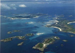
Whether or not the Scilly Isles were the legendary Cassiterides as some claim we do not know. Those who support the Phoenician—Cornish link usually quote Strabo (c. 54 BC to c. AD 24), a native of Amasia in Asia Minor. A much travelled man whose great work on geography survives almost intact in 17 books . His is the earliest known written record and he refers several times to the Cassiterides, or Cattiterides (double S and double T being interchangeable in Greek), and the island of Bretannika, often spelled with an initial P. The two locations may be referred to in the same passages. In book III he describes the islands in more detail in this famous passage:
"The Cassiterides are ten in number, and lie near each other in the ocean toward the north from the haven of the Artabri (Corunna). One of them is desert, but the others are inhabited by men in black cloaks, clad in tunics reaching to the feet, girt about the breast, and walking with staves, thus resembling the furies we see in tragic representations. They subsist by their cattle, leading for the most part a wandering life. Of the metals, they have tin and lead, which, with skins, they barter with the merchants for earthenware, salt, and brasen vessels. Anciently the Phoenicians alone, from Gades (Cadiz), engrossed this market, hiding the navigation from all others. When the Romans followed a certain shipmaster, that they might discover the market, the jealous shipmaster willfully stranded his vessel on a shoal, misleading those who were tracking him, to the same destruction. Escaping from the shipwreck by means of a fragment of the ship, he was indemnified for his losses out of the public treasury. (Ref. 2)
When you read this quote today with a twenty first century view of what Cornwall and the Scilly Isles look like on a map, it may be easy to discount them as having been the legendary Isles of Tin. However, at the time that Stabo was writing his account some two thousand years ago, I and others believe the geography of the area was a lot different. It is now believed that in the year B.C.100 the sea levels were lower than they are today and the Scilly Islands would have been much larger.
An archaeological model for the submergence of Scilly has been published by Professor Charles Thomas (Thomas 1985). In the absence of radio carbon dates for the inter-tidal zone to calculate sea level change since 3,000 B.C., he used the vertical positions of submerged archaeological sites, which could be broadly dated from artifactual evidence or by analogy with sites elsewhere. In his book he says:
"While the Islands have been separated from mainland Britain for many thousands of years, the depth of water between them is so shallow that Bryher, Tresco and Samson are still joined at low astronomical tides (LAT) and a fall of only 10 metres would unite them all, except St. Agnes and the Western Rocks. Scilly, therefore, represents a drowned landscape illustrated by the existence of causeways linking the Islands, submerged stone field boundaries and other archaeological sites within the inter-tidal zone of shallow interior sea." (Ref. 3)
According to Professor Thomas, his model represents "an average yearly rise in sea level of 2.1-2.6 millimetres, which means 21-26 centimetres every hundred years and 2.10-2.60 metres every thousand years."
I had correspondence with Dr. Benjamin P. Horton Head of the Durham University Department that studies sea levels. He wrote that: "We don' really know much about late holocene (last 4000 yrs) sea-level changes. what we do know comes from models and interpolation of earlier records. generally RSL were lower 3000BP than 2000BP for cornwall but with sea-level about 3m below present at 3000BP and 2m at 2000BP." (Ref.4) So he put the figure at nearer 1 meter per thousand years. Which would make the sea levels around the Cornish Coast and Scilly some 2 meters lower at the time that Strabo was writing.
Two meters would make a great difference to the size of the Islands and if Professor Thomas is right then 5 meters would make them even bigger.
It
is known that the Phoenicians used off shore islands when trading with
other people. they did this around the Mediterranean as a way of defending
themselves. Having set up their base the people would bring their goods
and trading would take place. On the Scilly's there is a headland which is still
known today as Merchants Point. The
oldest smelted specimens of tin were found at St.
Martin’s, Isles of Scilly, by the Rev. H. A. Lewis. They consisted of lumps of
tin in crude concentrates and were found inside an Early Bronze Age hut which is
now only visible for a few days in the year when there is an exceptionally low
tide. The site where the actual alluvial tin was found is unknown, but it was
probably in the bed of some unknown river now covered by the sea.
But this way of trading was to change once the Romans found out where the Tin Islands were. Let us return to our friend Strabo, we left at the time he was explaining how the sea captain had escaped from the Romans.
The
Romans, nevertheless, by frequent efforts discovered the passage; and as soon as
Publius (Licinius) Crassus, passing over to them, (about B.C. 95) perceived that
the metals were dug out at a little depth, and that the men were peaceably
disposed, he declared it to those who already wished to traffic in this sea for
profit, although the passage was longer than that to Britain. Thus far
concerning Iberia and the adjacent islands."
(Ref. 5)
It
is beleived that Stabo was referring to the distance to Britain across the Dover Straights which were
the only part of Britain known to the Romans at the time. Indeed Julius
Caesar, writing in B.C. 40 about Britain, in his "Wars" (v.12) had
this to say -
"The inland parts of Britain are inhabited by those, whose fame reports to be the natives of the soil. The sea-coast is peopled with the Belgians, drawn thither by the love of war and plunder. These last, passing over from different parts, and settling in the country, still retain the names of the several states whence they are descended. The island is well peopled, full of houses, built after the manner of the Gauls, and abounds in cattle. They use brass money, and iron rings of a certain weight. The provinces remote from the sea produce tin, and those upon the coast, iron, but the latter in no great quantity." Ref. 6
By the first
century B.C., Diodorus Siculus the Greek historian was writing of a voyage to
Britain and giving directions:
"Then all the rest of your voyage is eastward, thus making an obtuse angle to your former course, until you reach the headlands of the Pyrenees that abut on the ocean. The westerly parts of Britain lie opposite these headlands towards the north, and in like manner the islands called Cassiterides, situated in the open sea approximately in the latitude of Britain , lie opposite to, and north of, the Artabians." Ref. 7
So when Diodorus
was writing book two of his series of Histories the journey to Cornwall
from the Mediterranean was being done by sea all the way. Following the route
belived traveled by the Phoenicians through the Gates of Hades and across the
Bay of Biscay. Artabians is the modern La Coruna, [Corunna] the port in NW
Spain from which the Spanish Armada sailed in 1588. By the time he
came to write book five, the Roman were well established in Britain but not it
is believed in Devon and Cornwall which they called Balerium. Strabo gives us an
insight into The Cornish of the time and the method used for the mining of tin
plus the way trade was being conducted.
"Now we shall speak something concerning the tin that is dug and gotten there. They that inhabit the British promontory of Belerium, by reason of their converse with the merchants, are more civilised and courteous to strangers than the rest. These are the people that make the tin....."And not only do they go into the ground a great distance, but they also push their diggings many stades in depth and run galleries off at every angle, turning this way and that, in this manner bringing up from the depths the ore which gives them the profit they are seeking.".......which with a great deal of care and labour, they dig out of the ground, and that being rocky, the metal is mixed with some veins of earth, out of which they melt the metal and then refine it. Then they beat it into four-square pieces the size of dice, and cart it to a British island, near at hand, called Ictis. For at low tide, all being dry between them and the island, they convey over in carts an abundance of tin in the mean time. But there is one thing peculiar to those islands, which lie between Britain and Europe; for at full sea they appear to be islands, but at low water for a long way they look like so many peninsulas. .Ref.8.
Once again we return to the question of sea levels. It has often been said that Ictis was St Michael's Mount. However, with the sea level being two meters lower this would lead one to conclude that the Mount would have been inland and Ictis would have been an Island offshore i.e. one of the Scilly Isles or another island further up the coast where the trading took place. Stabo also tells us in book five, that the Romans had now developed an overland route for the tin trade:
Hence the
merchants transport the tin they buy of the inhabitants to France, and for
thirty days' journey they carry it in packs on horses' backs through France to
the mouth of the river Rhone. Thus much concerning tin." . . . .
Ref.9.
Some
time around 50 -60 A.D., the Cornish Tin industry must have been under threat
because of over mining and cheaper supplies being found in Spain. Pliny,
(23 - 79 A.D.) writing in his "Natural History" says:
"The
nature of lead comes next to be considered. There are two kinds of it, the white
(i.e., tin, called plumbum album) and the black (lead, called plumbum nigrum).
The white is the most valuable; it was called by the Greeks cassiteros; and
there is a fabulous story of their going in quest of it to the islands of the
Atlantic, and of its being brought in barks made of osiers, and covered with
hides. It is now known that it is the production of Lusitania and Gallaecia. It
is a sand found on the surface of the earth, and of a black colour, and is only
to be detected by its weight. It is mingled with small pebbles, particularly in
the dried beds of rivers. The miners wash this sand, and calcine the deposit in
the furnace. It is also found in the gold mines that are known as alutiae, the
stream of water which is passed through them detaching certain black pebbles,
mottled with small white spots, and of the same weight as gold. Hence it is that
they remain with the gold in the baskets in which it is collected; and being
separated in the furnace, are then melted, and become converted into white lead
(tin.)" . . . . "White lead was held in esteem in the days even of the
Trojan War - a fact attested by Homer, who called it 'cassiteros'."
Although this argument at first seems to back up the claim that the tin came from Spain and not Cornwall, Pliny then went on to say that:
"It
(tin) is extracted with great labour in Spain and throughout all the Gallic
provinces, but in Britannia it is found in the upper stratum of the earth in
such abundance , that a law has been spontaneously made prohibiting anyone from
working more than a certain quantity of it." Ref. 11.
I believe that the above is a strong argument that the Scillies were indeed the Cassiterides referred to. As I stated above, it is known that the Phoenicians used off-shore islands as bases to trade with people from the mainland or larger Island and the Scillies would have been an ideal base for them to visit the tin mining area coming ashore to do the actual trading. Indeed some Phoenician glass faience beads, from around 1600BC which must have been amongst the first products of the great Phoenician civilisation to reach Cornwall were found buried in a Bronze Age barrow on the Lands End in the 1800’s and are displayed at the Truro Museum. (Ref. 12)
In the next section we look at how these visitors left their legends and gods behind.
The
MermaiD OF ZENNOR
Home Page
REFERENCES
“Popular Romances of the West of England” Collected and Edited by Robert Hunt, F.R.S. Published in 1865.
Strabo Book 3.
Exploration of a Drowned Landscape: Batsford, 1985 Professor Charles Thomas.
Letter to the Author from Dr. Benjamin P. Horton of the Sea Level Research Unit, Department of Geography,University of Durham
ibid 1.
"Wars" v.12, Julius Caesar
Diodorus Siculus .Book II.v.15)
Diodorus Siculus. Book V:1-4, 35)
ibid
Pliny, Nat. Hist. book 34. Ch.47.
Ibid.