![]()
Refining The Search
For Noah's Ark
|
This Text Removes The Futility Of Searching An Extensive Desert Where Everything Looks The Same. Tell Noah Should Be Distinctly Different And Obvious To Informed Searchers. Searchers Now Have Something More Specific To Look For. |
Source Material: I presume you've landed on our page directory for Noah's Ark, City Built By Cain, And Edenic Valley Exploration (EVE). This is item 18 in the page directory.
http://brians_annex_ii.tripod.com/hats/inarabia.html#pgdir
Photographs Reveal Much: Mr. Mohammed M. Baarmah of Jeddah took a series of photos of the area 60 miles North of Tayma, Saudi Arabia back in January 1999 (see item 12 in page directory). His photos show a rather forlorn desert landscape; however, somewhere below that clay strewn landscape should be the ancient city built by Cain (Chanoch) perhaps covering a rather extensive area. The Koran in speaking of Noah's Ark as the howdah atop Al Judi (Sura 11) helps to link the landing site of Noah's Ark to Chanoch.
The clay visible in the photographs obviously was deposited by The Flood and Noah's Ark landed after The Flood and atop the clay deposits. Earth blown by the wind then covered the great wooden Ark overlaid with pitch. So, the mound covering the Ark should be mostly void of clay. Thus, Mr. Baarmah's pictures show that the Ark Mound (Tell Noah) is not visible in that immediate area. Then, if not there, where would one search?
Noah's Ark In Relation To Tayma: Scripture (Habakkuk 3:3) speaks of Tayma; and, Tayma most probably was the nearest visible or accessible fresh water source. And since the name Tayma is described as meaning "South" or "to the South" then the Ark should be to the North of Tayma. High resolution aerial photos of the strip from Tayma Northward may reveal a large squarish mound perhaps up to 3,000 feet on a side mostly void of clay. Now since there probably was no water in that particular area, all those on board the Ark apparently moved to reoccupy or establish Tayma to be near the water source, the ancient well in Tayma. The Ark was probably far enough away so people wouldn't commute. Otherwise someone would have already discovered Noah's Ark if it were much nearer Tayma. Note: Tayma may have been a preflood community that was somewhat exposed and intact after The Flood. How else would Flood survivors with Noah have located the well and possible structures?
A More Logical Starting Point: After considerable thought (without high resolution aerial photos), where would one start to look for Noah's Ark? Perhaps about 30-33 miles North of Tayma (i.e. about 28° 04' N, 38° 35' E). Why there?
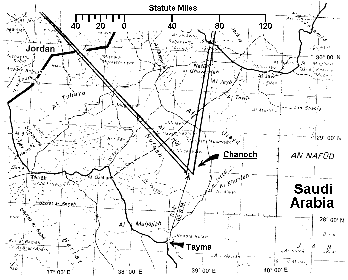 |
The Howdah, Tayma, And Chanoch: Again, the Koran speaks of Noah's Ark as a howdah atop Al Judi referring to Chanoch. If one were to draw a picture you'd have two or more approaches. One would be to put it directly atop Chanoch like the top layer of a layer cake. Mr. Baarmah's photos indicate that's not the right approach. A second would be to stand atop Chanoch and face Tayma "to the South." If you drew a picture, the Ark may be above (i.e. beside) Chanoch between you and Tayma. From that perspective the Ark would still be "atop" Chanoch like a howdah. Also, in view of Habakkuk 3:3, Noah's Ark would not be North of Chanoch.
"GOD (speaking of The Glory Of GOD atop the original Holy Ark) came from Teman, and the Holy One (Noah) from Mount Paran (the ornament in the desert)...."Habakkuk 3:3
Happy Hunting For Mount Paran (Habakkuk 3:3): The "Mount" indicates a large size in area; whereas, "Paran" meaning "the ornament in the desert" indicates it should stand out relative to surroundings. Let us know what you find. Pictures are appreciated especially if you locate a mound mostly void of clay. Remember, like in searching for GOD'S Holy Ark, that great triangle defined by the pyramid of Giza's measures apparently points the way to the many missing stones that support the missing capstone. See: "Searching For GOD'S Holy Ark," Parts I, II, and III:
http://brians_annex_ii.tripod.com/hats/searchingforarkpart1.html
Note: The design of Noah's Ark most probably conformed with the Levitical City measures with an amphitheatre centered therein. The amphitheatre, which enclosed a Temple, may have been covered with a large brass dome overlaid with gold. The brass provided strength and the gold protected the brass. Therefore, if this were the case, the peak of the dome should be very close to the surface of Tell Noah and easy to detect. Again, happy hunting!
FOUR ANCIENT RIVERS
Or
Page Directory
For: Noah's Ark, City Built By Cain,
and Edenic Valley Exploration (EVE)


| Prepared By Father - Son Team аааааааааGeorge & Dana Brown аааааааааP.O. Box 320932 аааааааааCocoa Beach, Florida аааааааааUSAаааааааааа32932-0932 аааааааааEmail: brianshouse@yahoo.com
|