
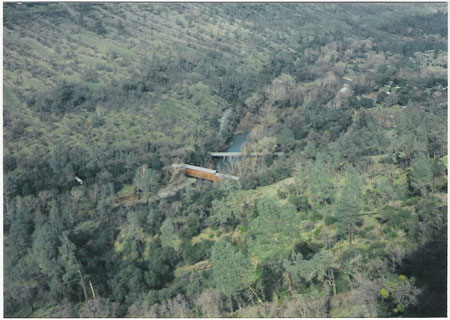
(Photo taken: March 3, 2007)
Hi, I'm Larry Matthews. I've been a history nut all of my life, and I have always been interested in bridges. Over the years, my special fascination has been with old, historical covered bridges and truss/suspension bridges in the Northern California area. I am even interested in some of the historic concrete highway bridges in this area.
You might think that all of the covered bridges are in the Eastern part of the United States. However, in Butte, Nevada and Yuba Counties there are four, beautiful and unique covered bridges that are well worth your visiting.
I have also included eight non-covered bridges from this area. I have written a short essay on all twelve bridges.
The great thing about all of these bridges is that getting there is half the fun. They are all located in beautiful areas. Additionally, as they are all located within 100 miles of each other you could visit them all in a day or two!
NOTE: I have updated the original essays on these bridges in order to incorporate several major changes in the bridge's status in 2017 and 2018.
Essays Include:
1. The Oregon Creek Bridge - Yuba County
2. The Bridgeport Bridge - Nevada County
3. The Honey Run Bridge - Butte County
4. The Oregon City (Castleberry) Bridge - Butte County
5. The Table Mountain Bridge - Butte County
6. The (Original) Bidwell Bar Bridge - Butte County
7. The Edwards Crossing Bridge - Nevada County
8. The Waldo Bridge - Yuba County
9. The New Bidwell Bar Bridge - Butte County
10. The Spring Valley Road Bridge - Yuba County
11. The Los Verjeles Road Bridge - Yuba County
12. The Dunstone Road Bridge - Butte County
COVERED BRIDGES IN NEVADA AND YUBA COUNTIES
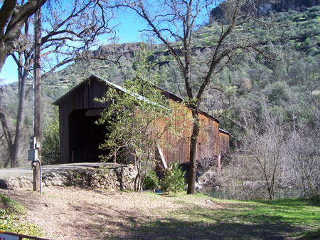
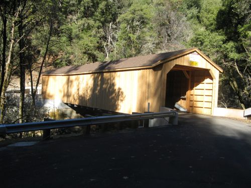
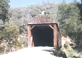
THE OREGON CREEK COVERED BRIDGE
(Photos taken: 12-15-92)
This 100 foot long bridge is also known as Freeman's Crossing. Having been hand built in 1860 it is still, amazingly, in use. However, I refuse to drive over it! It is very rustic and the roughest looking bridge on this web page. I first visited this bridge in 1992.
I had two sources regarding the year this bridge was built. One said 1860 and the other 1871. I am opting to say it was built in 1860 as that is the year that appears emblazoned on the front of the bridge. If that is accurate, that would make this bridge the oldest covered bridge in California.
(It is not the oldest bridge of any kind in California. That honor, as far as I can tell, belongs to the Bidwell Bar Suspension Bridge that was built in 1856 and has been relocated to the Lake Oroville Recreation Area. See "Historic Truss and Suspension Bridges" section below.)
To get to the Oregon Creek Bridge you drive 20 miles northwestward on Highway 49 from Nevada City. You go through North San Juan and continue for a few miles. Make a right where you see the Oregon Creek Campground area. The bridge is located just down the road a bit, at the intersection with Allegheny Road. Even though I always thought it was located in Nevada County, the bridge is actually just inside Yuba County.
The uniqueness of this bridge is the fact that it is installed backwards!
In 1883 it was washed 150 feet downstream when a dam broke. As it washed downstream it turned end to end. A team of oxen was used to tow the bridge back into place. However they reinstalled the bridge backwards.
Drive, or preferably walk, across the bridge and you can enjoy a picnic and swimming area.
A great location to enjoy a summer day.
UPDATE: During the summer of 2017 this bridge was totally rebuilt and is now in wonderful shape. You can drive across it and it is brand new.
Here is a photo of the rebuilt Oregon Creek Bridge that was taken in December 2017.

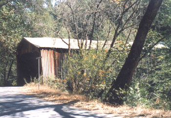
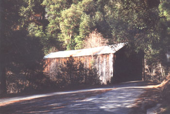
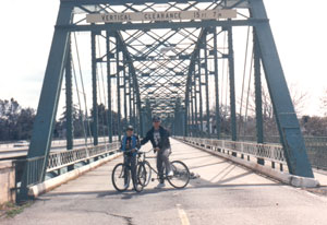
THE BRIDGEPORT COVERED BRIDGE
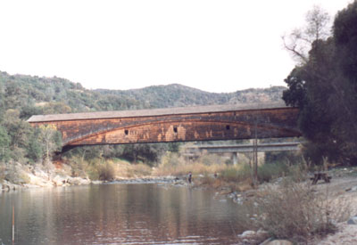
(Photos taken: 12-15-91 and 3-17-00.
This bridge's claim to fame is that it is the "longest single span covered bridge in existance". However, it depends upon how you measure it. If you measure it from pier to pier it is 208 feet long (shorter than one in New York state). However, if you measure it from portal to portal it is 233 feet long. One thing that is not in contention is that it does have the longest roofline in existance, for a single span covered bridge.
The honor of being the "longest" covered Bridge west of the Mississippi River belongs to the Knights Ferry Covered Bridge in Stanislaus County, California. It crosses the Stanislaus River and it's 330 feet long but is more than a single span. Check this bridge out at the link below!
I first visited the Bridgeport Bridge in 1973.
It is definately the most beautifully preserved of the bridges on this page. (The bridge has been repaired and restored several times. The last time being after the major flood damage of 1997). The bridge was constructed in 1862 and is shake covered. It spans the South Yuba River as part of the old Virginia Turnpike Company toll road that connected the Nevada County mines to the Comstock Mines.
David Ingerfield John Wood built this bridge and transported all materials from his mill in Sierra County.
I have spent many wonderful hours in it's shade during swimming, hiking and picnic excursions. Great memories!
The bridge, located at Nye's crossing, is in Nevada County and you can find this bridge by heading East from Marysville on Highway 20. Make a left turn at Pleasant Valley Road and keep going until you come to the South Fork of the Yuba River. It's located on the left.
As of October 21, 2011, the bridge is closed to all traffic, including pedestrian. I has been found that the bridge is starting to shift and twist. It will be closed until a $20,000.00 engineering analysis and future repairs are made. The bridge reconstruction is going well and it is hoped that completion of the repairs will be successful and the bridge condition will be better than ever. Completion of the bridge is expected in mid-2020.
(Photo taken 3-17-00)
COVERED BRIDGES IN BUTTE COUNTY
THE HONEY RUN COVERED BRIDGE
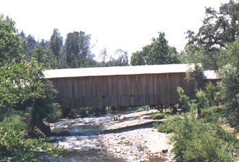
(Photo taken: 6-15-84)
The Honey Run Covered Bridge is located 8 miles East of Chico, in Butte Creek Canyon. You can get there by taking the Park Avenue exit off of Highway 99 and heading East toward Paradise. Make a left on Honey Run Road and keep going. The bridge is located on the right just before you come to the road toward Centerville.
This well preserved bridge crosses Butte Creek and boasts that it is the only covered bridge in the U.S. with three distinctive roof lines. It was greatly damaged on April 12, 1965 when a truck destroyed one third of the bridge by falling through it. The county decided to tear the bridge down, but through the efforts of the Honey Run Covered Bridge Association it was saved. They held a Pancake Breakfast that raised $7,000.00 for repairs. Since that time an annual pancake breakfast has been held to maintain the bridge in it's excellent state.
The Honey Run Covered Bridge was built in 1894 by George Miller. I first visited it in 1976.
How did the Honey Run Bridge get it's name? One of several stories states that a young man was being chased by bees near the bridge and he yelled to his girlfriend "Run, Honey, Run!"
The Honey Run Covered Bridge. Taken from the Paradise Ridge in February 1995.
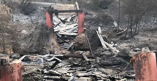
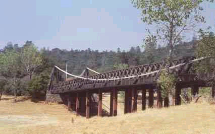
UPDATE: On November 8, 2018 the Honey Run Covered Bridge was totally destroyed by the Camp Fire. There are major efforts ongoing to have the bridge rebuilt. Here is a photo of the bridge right after the fire.
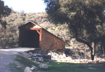
THE OREGON CITY COVERED BRIDGE (CASTLEBERRY COVERED BRIDGE)
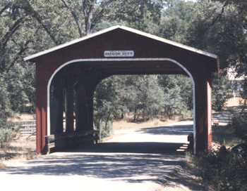
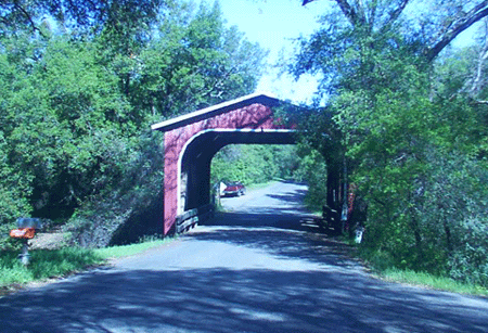
(A South and North View)
(Photos taken: 8-17-88 and 4-20-02)
The Oregon City Covered Bridge is located just off of Cherokee Road on Table Mountain. You can get there by taking Highway 70 to Oroville and heading East on Grand Avenue. Go to Table Mountain Blvd and make a left. Go a few blocks and make a right on Cherokee Road and follow the road toward the top of Table Mountain and follow the signs. You have the option of taking the dirt Oregon Gulch Road (very dusty) all the way to the bridge, or you can just stay on Cherokee Road to the top of Table Mountain, cross the mesa, and then make a right off of Cherokee when you see the sign for the Covered Bridge. I recommend you take the Cherokee Road route all the way.
This Covered Bridge is the newest in the nation. Built in 1984 it is located only a few feet from the historic Oregon City School. It is a 50 foot, barn red bridge. The trip up to and across beautiful Table Mountain is part of the joy of a visit to the bridge.
The building of this bridge was spearheaded by Clay Castleberry, retired Public Works Director for Butte County, and all materials and labor were donated by volunteers!
I was there for the dedication and was told that, at one time, there had been another covered bridge at that site. However, for many years just a regular highway bridge crossed the small creek where the Covered Bridge now stands.
HISTORIC TRUSS AND SUSPENSION BRIDGES
Here are five non-covered bridges in Butte, Nevada and Yuba Counties that are historically significant.
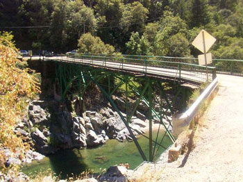
THE TABLE MOUNTAIN (UPPER THERMALITO) BRIDGE.
(Photo taken: 3-11-90)
Built in 1907. This highway bridge crosses the Feather River from downtown Oroville to Table Mountain Boulevard northward. It was used until the 1980's when it was bypassed by a new concrete bridge. Still used for pedestrians and bike riders. Still in great shape. I first visited this bridge in 1962.
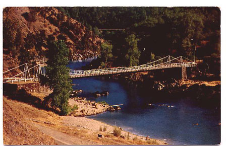
THE (ORIGINAL) BIDWELL BAR BRIDGE.
Old postcard of the original Bidwell Bar Bridge, at its original location, in the 1950's.
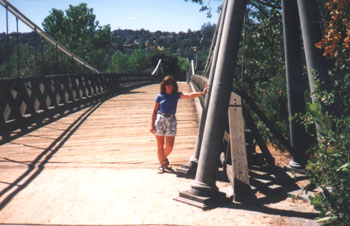
My wife, Sharon, visiting the relocated bridge in September 1995.
The relocated bridge in September 1995.
It was the first suspension bridge in the western states and was completed in 1856 when Bidwell Bar, early day Butte County seat, had several thousand persons and was a widely known mining center. The materials were ordered from Troy, NY in the early 1850's and shipped around "the horn" of South America to San Francisco. Then they came up river to Sacramento and Marysville and by wagon to Bidwell Bar. The bridge, at it's original location, was 372 feet long. It spanned 130 feet of river bed and was 29 feet above water level. I first visited this bridge in 1964.
This bridge was removed from it's original location at Bidwell Bar in 1966 to save it from being inundated by the rising waters of Lake Oroville. It now is no longer a "suspension" bridge but is nicely preserved, with it's original toll house, near the area of Bidwell Marina and Wycks Island on Lake Oroville.
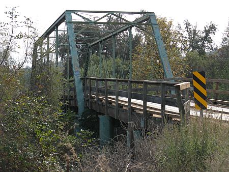
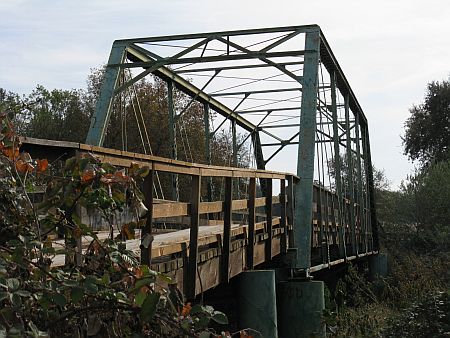
THE EDWARDS CROSSING BRIDGE
(Photo taken: 7-01-01)
This Nevada County bridge is located between Hwy 49 and North Bloomfield/Malakoff Diggins on North Bloomfield Road, north of Nevada City. It was built in 1904 and is 114 feet long with 3 hinged metal arches. It's the fourth bridge built in that location, the first having been built in the 1850's. I first visited this bridge in 1968. It's quite a sight coming down the steep hill from Nevada City. Just don't burn your brakes out on the narrow, winding road. Located over the South Yuba River, it's a favorite swimming area. Clothing is apparently optional just around the river bend....
THE WALDO BRIDGE
(Photos taken: 11-9-11 by Scott Roberts)
The Waldo Bridge is located in the midst of the Spenceville Wildlife Area in Yuba County. It is located on Waldo Road, which so happens to be a gravel/dirt road. If you go there be prepared to travel over some of the most pot-holed roads in Yuba County. The closest good road is Hwy 20 between Marysville and Grass Valley. You get off of 20 onto Smartville Road (toward the Beale AFB "Grass Valley Gate") and then branch off to dirt Waldo Road. But the trip is well worth it as it is a beautiful and unspoiled area.
The Waldo Bridge is a century old, having been built in 1901 to serve the now-vanished towns of Waldo and Spenceville. It crosses Dry Creek, which I have never seen dry. It is a metal truss bridge that still has its original wooden planking for the roadway. It's a narrow, one-lane bridge. It was closed for repairs for awhile in 2009, but it has since reopened. I first visited this bridge in June 1994.
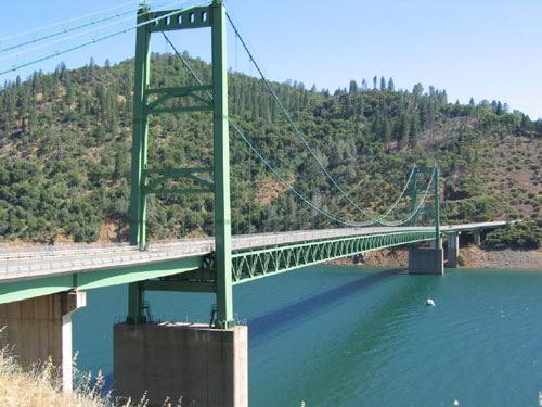
THE NEW BIDWELL BAR BRIDGE
(Photo taken: 7-06-03. Photo by Scott Roberts)
The New Bidwell Bar Bridge was built from 1965-1967 to replace the Old Bidwell Bar Bridge that was moved out of the canyon to save it from being inundated by the rising waters of Lake Oroville. It was certainly a big accomplishment. For awhile it was known as one of the highest suspension bridges in the world. I personally know just how scary it used to be to look down into the canyon from the bridge. But, as Lake Oroville rose to its present level the height deteriorated. Now you look at the bridge and it doesn't seem to be much of an accomplishment. But when it was made, the river below looked like a tiny, narrow ribbon of blue. The bridge originally stood 627 feet above the river bed. The bridge is 1,108 feet long.
It's a beautifully styled bridge that carrys very little traffic between Oroville and Berry Creek. But that does not diminish the beauty of its design or its uniqueness of purpose. I first visited this bridge a few days after it was dedicated in 1967.
CONCRETE HIGHWAY BRIDGES
Here are three historic highway bridges in Yuba and Butte Counties.
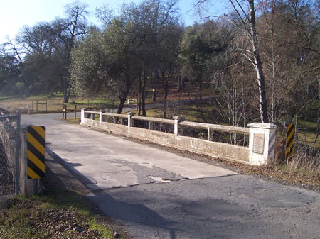
(All photos taken: 01-20-07)
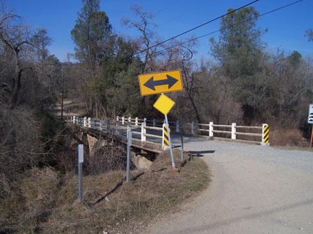
THE SPRING VALLEY ROAD BRIDGE
The Spring Valley Road Bridge was built in 1920 and is located near the East end of Spring Valley Road in Yuba County and crosses Little Dry Creek. This road lies between Highway 20 and Marysville-La Porte Road. Obviously the county government was very proud of this bridge at the time as the plaque on the bridge gives the year built and a list of the names of the then County Supervisors.
When crossing it, be cautious as it is a very narrow two lane bridge. Maybe back in the 20's cars weren't so wide and two might have been able to pass each other easily. Don't bet your life on that now! I first visited this bridge in 2007.
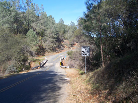
THE LOS VERJELES ROAD BRIDGE
The Los Verjeles Road Bridge was built in 1940 and crosses South Honcut Creek, barely inside the north border of Yuba County. Across the bridge is Butte County. Its length is 58.1 feet. The bridge has been well used by millions of cars. It sits just a few miles south of Bangor and is on a main route between that town and the towns of Loma Rica and Browns Valley. It's a well worn bridge and really shows its age, along with a fair amount of graffiti. I first visited this bridge in 1969.
Just a few feet downstream from the bridge is a very popular swimming hole known as "Little Rocky Honcut".
I see that the Yuba County Public Works master plan had planned to replace this bridge in 2010. However, there has not been any activity toward that goal yet.
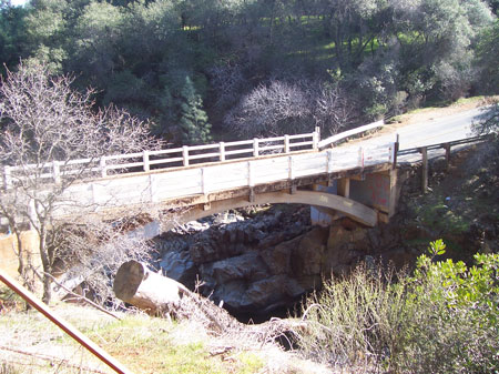
THE DUNSTONE ROAD BRIDGE
The Dunstone Road Bridge is located virtually out in the middle of nowhere. It's on a gravel road and is a good 6 miles from any blacktop road and major civilization in any direction. It's located at the intersection of Dunstone Road and Avacado Avenue. Dunstone Road runs from the southern area of Oroville, south to La Porte Road.
It's one of the most isolated bridges in Butte County and does not receive a lot of traffic - unless you consider an occasional dust covered pickup truck a lot of traffic.
Built in 1930, the bridge crosses North Honcut Creek, a tributary that makes its way out of the mountains and to the west where it empties into the Feather River. I first visited this bridge in 1969.
I am happy to say that I took most of the pictures that appear on this web site. It was great fun searching out the bridge sites and enjoying the beautiful areas in which they are located. I am sure you also would enjoy visiting all of these bridges!

Larry Matthews

THIS IS A "LARRY" WEB SITE.