|
| |

Here's the route we took, and
the places we stopped.


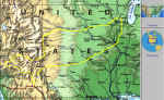 |
Overview of entire route across the United States. |
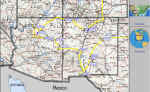 |
Detail of Arizona and New Mexico with stops
displayed.
|
| Label: |
GPS
Data (UTM NAD83) |
Comment: |
| Zone |
Easting |
Northing |
| MADTWN |
16T |
304508 |
4771010 |
Madison, WI. |
| STROSA |
13S |
528130 |
3877234 |
Santa Rosa, NM. |
| VFIRES |
13S |
408910 |
3710878 |
Valley of the Fires |
| PET |
13S |
406184 |
3689964 |
Sand Creek Petroglyphs, NM |
| WSANDS |
13S |
386180 |
3629160 |
White Sands, NM |
| KILBRN |
13R |
315005 |
537130 |
Kilbourne Hole, NM |
| BOMB |
13R |
315182 |
537463 |
Volcanic bomb at Kilbourne Hole |
| WALDO |
13S |
296122 |
3774481 |
Waldo Mine, NM. |
| LYMAN |
12S |
649299 |
3803249 |
Lyman Lake, AZ |
| FOREST |
12S |
613681 |
3866403 |
Petrified Forest, AZ. |
| METEOR |
12S |
497941 |
3876736 |
Meteor Crater, AZ. |
| CANYON |
12S |
399239 |
3990130 |
Grand Canyon, AZ. |
| SP |
12S |
442370 |
3938594 |
SP Crater, AZ. |
| RANCH |
12S |
431193 |
3940069 |
Babbitt Ranch, AZ |
| WOOD |
12S |
429026 |
3934023 |
Petrified Wood |
| SHIPRK |
12S |
693699 |
4061400 |
Shiprock NM. |
| BAND |
13S |
384302 |
3962239 |
Bandelier, NM. |
| RUINS |
13S |
385172 |
3960188 |
Bandelier, NM. |
| LOTUFF |
13S |
391588 |
3969961 |
Tuff bed |
| ASH |
13S |
356445 |
3965934 |
Ash bed |
| BATSHP |
13S |
351538 |
3966337 |
Battleship Rock, NM |
| FALLS |
13S |
347549 |
3962253 |
Travertine Dam and waterfall |
This
page was last updated on 05/11/01
To
report problems, ask questions, etc., please contact
Reuben
Johnson at: rcjohnson@students.wisc.edu
|