| Gaylor and Granite Lakes "Tarns Forever" | September 17, 1997 |
|
|
|
Heinous Factor: Steep trail getting over the ridge from the entrance station to the lakes basin. Contouring around Gaylor Peak on the loose metamorphic scree got so heinous we backed off and went down and walked in the meadow instead. Steep trail from the lakes basin up and over the ridge to the entrance station.
Today's project was to hike up to Gaylor and Granite Lakes, and being lazy like we are, we
 opted to take the one mile trail from the Tioga Pass entrance station instead of the three mile trail from a trailhead on route 120 near Lembert Dome. opted to take the one mile trail from the Tioga Pass entrance station instead of the three mile trail from a trailhead on route 120 near Lembert Dome.
We parked in |
 a turnout just before the entrance station, and cross-countried it over to the trail, which actually begins at the parking lot just inside the park.
The trail rises steeply up to the top of the rise between the entrance station and Middle Gaylor Lake, with lots of rock steps and about 7 switchbacks.
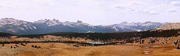
About halfway up, the trail skirts a scree slope and there is a wonderful large flat granite boulder that was perfect for stopping for a break on. We admired the view of the meadow, and counted 18 small ponds, or tarns, that we could see from there.
a turnout just before the entrance station, and cross-countried it over to the trail, which actually begins at the parking lot just inside the park.
The trail rises steeply up to the top of the rise between the entrance station and Middle Gaylor Lake, with lots of rock steps and about 7 switchbacks.
About halfway up, the trail skirts a scree slope and there is a wonderful large flat granite boulder that was perfect for stopping for a break on. We admired the view of the meadow, and counted 18 small ponds, or tarns, that we could see from there.
At that point we started up the switchbacks and soon were on top
 of the rise above Middle Gaylor Lake.
Looking over Middle Gaylor, you could see Granite Basin with its 2 glacialy carved lakes in the distance (more on this later).
To our right stood Gaylor Peak, and on the other side of Gaylor Peak, a saddle that we knew looked down onto Tioga Lake.
We decided to try to contour around the side of Gaylor Peak into the saddle, rather than descending to the lake.
This was ok at first, with patches of scree alternating with patches of trees.
But as we got around toward the north end of the mountain, there got to be less and less trees and more and more scree.
It got more and more heinous, and shortly I was over this walking through the scree stuff.
We opted to descend into the meadow.
of the rise above Middle Gaylor Lake.
Looking over Middle Gaylor, you could see Granite Basin with its 2 glacialy carved lakes in the distance (more on this later).
To our right stood Gaylor Peak, and on the other side of Gaylor Peak, a saddle that we knew looked down onto Tioga Lake.
We decided to try to contour around the side of Gaylor Peak into the saddle, rather than descending to the lake.
This was ok at first, with patches of scree alternating with patches of trees.
But as we got around toward the north end of the mountain, there got to be less and less trees and more and more scree.
It got more and more heinous, and shortly I was over this walking through the scree stuff.
We opted to descend into the meadow.
|
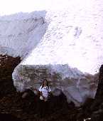
| We skirted the bottom of Gaylor Peak and shortly were at Upper Gaylor Lake, which lies to the northwest of Gaylor Peak. There is a small snowfield that lies on Gaylor Peak and comes down all the way to the lake. We walked beneath the snowfield (it was about 8 feet tall at the edge of the lake) and out onto the ridge overlooking Tioga Lake. | 
|
 From there we could see a few small lakes on the trail from Tioga Lake up to Bennetville, an old mining town.
We had hiked to Bennetville from the Tioga Junction Campground earlier in the year, and now we made plans to do the hike from Tioga Lake sometime in the future.
From there we could see a few small lakes on the trail from Tioga Lake up to Bennetville, an old mining town.
We had hiked to Bennetville from the Tioga Junction Campground earlier in the year, and now we made plans to do the hike from Tioga Lake sometime in the future.
 We also had a great view of Mt. Dana and Mt. Gibbs.
We walked up the ridge to the north, and began to run into old gold mine diggings. We followed a very obvious vein of yellow rock up the ridge and every so often there would be some diggings. As we went further up the ridge, the diggings got deeper and more extensive. |

| 
| 
|
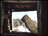
| In a saddle at the top of the ridge was the "community" of the Great Sierra Mine. The buildings had been piled rock walls, probably with wooden roofs which by now had been first used as timbers in the mines and later as fire wood by "tourists". | ||


| 
One building was much larger than the rest, probably the community room/mess hall. | 
|
| 
|

| ||
| As you drop down from the saddle and the Great Sierra Mine, it is easy to cut over and pass Granite Lakes before returning down the switchbacks to the entrance station. | ||
![]()
 |
Scotty & Keith's 3rd Class Adventures Home Page |