Hurricane Catarina, an extremely rare tropical event in the South Atlantic,
made landfall on the Eastern Brazilian Coastline during March of 2004.
Hurricane Catarina Strikes Brazil in March of 2004

Convert To Any Language Here

|HOME | HURRICANE CATARINA | EARTHQUAKE ACTIVITY | VOLCANO ACTIVITYSOLAR ACTIVITY |
UNITED STATES SATELLITE IMAGESUNITED STATES RADAR IMAGES | WORLDWIDE SATELLITE IMAGES |

Infrared Satellite Image of Catarina...Moving Westward Toward the Brazilian Coastline.
Catarina Satellite Image

Reference: http://www.ncdc.noaa.gov/oa/climate/research/2004/mar/hazards.html

Text added. Tropical Cyclones below the Equator, such as Catarina, rotate
clockwise when viewed from space. Cyclones above the Equator rotate counter clockwise.
Before continuing, it would be best to view the "track" of Catarina below. End of text added.

This South Atlantic Hurricane developed from an extratropical cyclone that emerged off the Coast of
Brazil on the 20th of March 2004. This nearly stationary non-tropical low pressure system, acquired
tropical characteristics, and developed into a hurricane by the 26th. The hurricane made landfall along
the southern coast of Brazil in the state of Santa Catarina just South of the resort town of Laguna early
on the 28th of March. Maximum sustained winds were estimated between 120-130 km/hr, 65 to 70 knots,
or 75 to 80 mph...with gusts to 155 km/hr, 85 knots, or 95 mph. The storm left at least three people dead
and injured 38, while more than 2,000 were rendered homeless (Associated Press). This was the first
documented hurricane in the South Atlantic Ocean since geostationary satellite records began in 1966.


An Enhanced Infrared Satellite Image Before Landfall on the Brazilian Coast.
Catarina Enhanced Satellite Image

The approximate Track and Wind Speeds of Hurricane Catarina.
Catarina Track & Wind Speeds

Complete Hurricane Catarina Information including a 40 Frame IR Satellite Loop

Satellite Images & Loops from the Satellite Services Division SSD of NOAA.GOV

Reference: http://science.nasa.gov/headlines/y2004/02apr_hurricane.htm

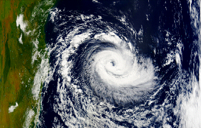
When the storm crashed into Brazil, local observers weren't even sure it was a hurricane.
Brazil has no ground-based network of weather stations to measure wind and
rain from tropical storms. "There are no Hurricane Hunters in Brazil..." adds
NASA hurricane researcher, Robbie Hood, "...the storms are so rare."

Space satellites, however, gathered a great deal of data. "NOAA polar orbiting satellites
measured the temperature of the storm's eye..." says climate scientist Roy Spencer
of the University of Alabama, Huntsville "...that told us how fast the winds were moving."
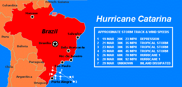
It was a category 1 hurricane, he says, an estimate confirmed by NASA's wind-measuring
QuikScat satellite. In addition, NOAA's GOES satellites and NASA's Terra and Aqua satellites
took pictures of the storm at microwave, infrared, and visible wavelengths, allowing scientists to
monitor the motions of moisture and heat energy through the storm--valuable data, indeed.

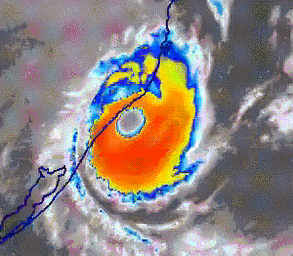
The TRMM spacecraft, a joint mission of NASA and the Japanese space agency, flew over
the storm several times in the days before landfall, and it gathered perhaps the most
revealing data of all. TRMM, short for Tropical Rainfall Measuring Mission, carries a
precipitation radar, the only one in space. Beaming down through the clouds, the radar
illuminated spiraling bands of rainfall; false color images of the storm resemble a pinwheel
galaxy! Combining data from the radar and the spacecraft's microwave imager, researchers
can estimate rain rates throughout the hurricane...from top to bottom, from eye to edge.

"This whole episode highlights the advantages of satellites for hurricane studies,
especially where there are no aircraft standing by to fly through the storms,"
says Hood. "Satellites can monitor storms in all parts of the world."

But a problem remains...what to call them? The World Meteorological Organization
maintains a list of hurricane names for every part of the world, except the south Atlantic.
Sadly, the March 28th storm did damage to remember: 500 homes ruined, fishing boats
sunk, at least two people dead and 1,500 more homeless. Brazilians are going to be
talking about the storm for a long time, and wondering about hurricanes to come.

South Atlantic hurricanes need names. Somebody somewhere, probably, is making a list.


Is it possible that there have been many more Tropical Cyclones such as Hurricane Catarina
in past history? Fleets of many Nations sailed the North and South Atlantic for Centuries.
Their archives show wind speeds and barometric pressure readings, that today would
meet the now definition of "Hurricanes", although no such name was then applied.

Reference for the following comes from http://www.nhc.noaa.gov/pastdeadly.shtml
Use of the words "hurricane and hurricanes" is meant only to indicate
something resembling a hurricane in force or wind speed.

The legacies of Atlantic tropical cyclones span many cultures and thousands of years. Early
evidence of these storms predates extant weather records. Geologists believe that layers
of sediment at the bottom of a lake in Alabama were brought there from the nearby Gulf of
Mexico by storm surges associated with intense hurricanes that occurred as much as 3,000
years ago (Liu and Fearn 1993). Similarly, sediment cores from the Florida west coast indicate
exceptional freshwater floods during strong hurricanes more than a thousand years ago.

Perhaps the first human record of Atlantic tropical cyclones appears in Mayan hieroglyphics
(Konrad 1985). By customarily building their major settlements away from the hurricane-prone
coastline, the Mayans practiced a method of disaster mitigation (Konrad 1985) that, if
rigorously applied today, would reduce the potential for devastation along
coastal areas (e.g., Pilkey et al. 1984; Sheets 1990).

Many storms left important marks on regional history. In 1609, a fleet of ships carrying
settlers from England to Virginia was struck by a hurricane.  Some of the ships were
damaged and part of the fleet grounded at Bermuda (The Encyclopedia Americana 1994).
The passengers became Bermuda's first inhabitants and their stories helped inspire
Shakespeare's writing of The Tempest. (Carpenter and Carpenter 1993).

In several incidents, tropical cyclones destroyed otherwise invincible colonial armadas (Millas
1968; Hughes 1987). The French lost their bid to control the Atlantic coast of North America
when a 1565 hurricane dispersed their fleet, allowing the Spanish to capture France's Fort
Caroline near present-day Jacksonville, Florida. In 1640, a hurricane partially destroyed a
large Dutch fleet apparently poised to attack Havana. Another naval disaster occurred in 1666
to Lord Willoughby (the British Governor of Barbados) and his fleet of seventeen ships and
nearly 2,000 troops. The fleet was caught in a hurricane near the Lesser Antilles. Only a
few vessels were ever heard from again and the French captured some of the survivors.
According to Sugg (1968), the 1640 and 1666 events secured, more or less,
control of Cuba by the Spaniards and Guadeloupe by the French.

More than two centuries later, commenting on the Spanish-American War, President McKinley
declared that he feared a hurricane more than the Spanish Navy (Dunn 1971). McKinley's
concern translated to a revamped United States hurricane warning service,
forerunner of today's National Hurricane Center (NHC).

Surviving quantitative documentation about specific storms generally begins late in the 15th
century during the period of New World exploration. A succession of chronologies brings the
record forward to modern times (e.g., Poey 1862; Tannehill 1940; Ludlum 1963; Millas 1968).

The United States maintains "Monthly Weather Review Atlantic Annual Summaries"
from 1881 to the present in PDF format. Access to these records
can be made through the National Hurricane Center

Now, back to the question..."Is it possible that there have been many more Tropical
Cyclones such as Hurricane Catarina in past history?" You must be the judge!!!

Return to Significant Tropical Storms Worldwide

| SITE MAP | LEGION INTERNET DIRECTORIES | POST LOCATION DIRECTORIES | TROPICAL STORMS WORLDWIDE |
HOME
CREATED AND MAINTAINED BY AMERICAN LEGION POST 119 GULFPORT MISSISSIPPI AS
A SERVICE TO THE AMERICAN LEGION COMMUNITY AND ALL VETERANS ORGANIZATIONS
EMAIL