The Cairn Cross
Discovery
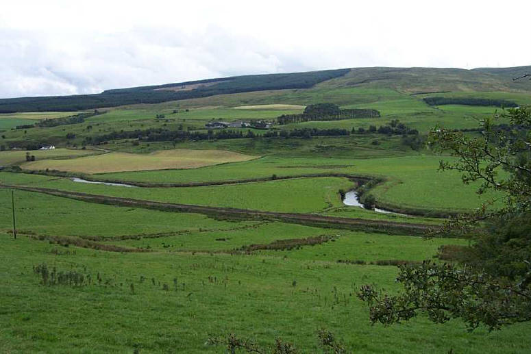
The Reverend Hewat sets the scene. 'The farm of Cairn, or as it is sometimes called The Cairn, is in the parish of New Cumnock some 3 miles from the village of that name which lies to the north. The farmhouse stands high and overlooks the River Nith. At a distance of 300 yards from the steading is the boundary between the shires of Ayr and Dumfries, the same boundary wall or dyke dividing the parish of New Cumnock from that of Kirkconnel. The Cairn is on the estate of the Marquis of Bute, and the present tenant is Mr James Stevenson, who received me very courteously and gave me a considerable amount of information regarding the discovery of the cross, which he values very highly'.The fragments of the cross were found by Mr Stevenson , three years earlier in 1897. Heavy rain, not uncommon in this corner of Ayrshire, had caused many of the burns that drain off The Knipes, to flood and speed their way to the waiting River Nith in the valley below.
The Reverend Hewat relates 'the little stream, which flows past his (Mr. Stevenson) farm, came down in exceptionally high flood, and carrying away a considerable amount of soil, laid bare one of the portions of the cross. This was pretty high up on the hillside. In the haugh below, while some large stones were being removed to make way for the plough, the other portion was discovered about the same time. Doubtless in some previous flood (or in the same flood) it had been carried down the stream. Local tradition says that a chapel, or religious house, stood where the larger portion of the Cairn cross was found'
Efforts were made in the 1950's to try and trace the cross fragments and the site of the chapel but sadly these were unsuccesful. 'Enquiries made at the farms of Over Cairn (NS 670 130) and Nether Cairn (NS 667 130) failed to reveal any information regarding this cross-shaft and arm. It is considered that the farm of Nether Cairn is more likely to be that on which the find was made. It is backed by rising ground, whereas Over Cairn farm is situated on ground falling away to the river. No trace was found of the cross or chapel during perambulation of the area.' [RCAHMS ]. I n fact the farm on the rising ground is called Over Cairn and the nearby by stream is called the Park Burn . Disappointingly, still to this day no traces of the cross or the chapel can be found.
Description
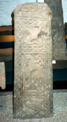
The sculpture is incised, the background of the panel and the spaces between the strands of the interlaced work being merely picked out with a pointed tool, and the pattern thus left in semi-relief. The pattern is an interlacement of two strands, each strand duplicated by a line along the middle, with a loop at the bottom, and rings interlaced round each crossing of the strands upwards The reverse face seems to have a square of four triangles, made by double diagonals interlacing in triangular loops at the bottom, and over that an interlacing pattern of double triangular knots facing to right and left. The edges (left and right) of the cross-shaft have each a simple plait of two undivided strands running upwards from a square-ended loop at the bottom.'
The Reverend Hewat description reads -'The arm shows a rope moulding round the margin on both sides the obverse and reverse faces having each a double triangular loop of interlacement of two strands not divided along the middle. If the arm and shaft are parts of the same cross, it must have been a cross of the form which has a large shaft carrying a propotionally small-sized and equal-armed cross-head of the sections found'.
Origins
The 9th century Mansfield Cross, New Cumnock probably marked the extent of the establishment of Northumbrian or Anglian minsters in Upper Nithsdale. However, by the end of that century, the Northumbrian stranglehold on Northern England and south-west Scotland had began to collapse. The Danes had taken York in 867 and Carlisle would fall within the next few decades. This opened up access to Dumfriesshire and subsequent settlement as witnessed by the numerous place-names of Scandinavian origin in that county. Further evidence of Danish settlement is ' the pagan influence seen in the crosses from Wamphray, Closeburn (below left) and Glencairn'. [I. MacLeod]
'The Cairn Cross fits into the type of carving that was common in that area in the 10th century. The continuous ring on the main face(below centre) is characteristic of Scandinavian-influenced style of that period, and so are the simple twisted patterns on the edges( below right).'
[Private Correspondence, RCAHMS].
Having shown that the Anglian Mansfield Cross was found close to the Anglian settlement of Corsencon, it is disappointing not too find evidence of a Scandinavian setttlement name in the vicinity of the Scandinavian influenced Cairn Cross. The farms of Cairn sit on the lower slopes of The Knipe (or the Knipes, as it is known locally), a name that is also found in the neighbouring parish of Kirkconnel as High
Knypes, Low Knypes and Meikle Knypes, all of which may derive from [Scandinavian] gnipa 'steep hill'. Further upstream of the River Nith is the hillside known as 'The Coupla' which may be Scots coup law 'bargaining or market hill' < Old Norse kaup 'trade, market'.
Purpose
Crosses were were erected to the glory of God, as focuses for public worship or private meditation, in places where chapels and churches were later built, in burial grounds, at entrances and boundaries, including sanctuaries, or at significant places on routes. They were not normally grave-markers, although they might bear an inscription requesting prayers for the patrons and their deceased relatives ' [ Private Correspondence, RCAHMS].
Location . The exact spot where the Cairn Cross stood cannot be identified with any certainty. However, the farms of Cairn sit strategically at what effectively is the head of Nithsdale. Evidence of the route of a Roman Road through Nithsdale on the opposite bank of the River Nith has already been presented under the Mansfield Cross.
Boundary : The location of the Cairn Farms certainly fits the criteria of crosses marking boundaries . Both farms sit close to the March Burn ('boundary burn') that marks not only the New Cumnock / Kirkconnel parish boundary but also the former Ayrshire / Dumfriesshire county boundary, with their origins in the ancient sheriffdoms of Ayr and Nithsdale. Nearby, and running parallel to the the Nith Valley is the remains of the 'Deil's Dyke', a medieval forest or park boundary, parts of which have been shown to overlay an Iron Age territorial or tribal boundary.
Pont (see Blaeu's map) also records Bryds burn running alongside the March Burn and this may be the 'Briton's burn', again marking some tribal boundary. The Dark Age boundaries of the ancient British kingdoms of Kyle and Rheged may also be worthy of consideration. Furthermore, the place-name Cairn [Gaelic] carn 'pile of stones' is also indicative of a boundary marker. The name Cairn is very common in this stretch of Upper Nithsdale with the farms of Over Cairn and Nether Cairn in the New Cumnnock side of the county boundary and Laigh, High and Nether Cairn on the Kirkconnel side. However, the name Cairn can also suggest an ancient burial cairn but there are no records of such a cairn in this vicinity.
Ecclesiatical Sites : The Reverend Hewat cites the Mansfield Cross and the Cairn Cross as evidence of ecclesiastical sites that pre-date the pre-Reformation churches at Kirkconnel and New Cumnock. In fact, the Auld Kirk at New Cumnock was erected after the Reformation in 1659. However, a few miles to the west in the parish, is the small community of Dalleagles dal eglwys 'land of the church', is clearly indicative of an early Celtic church. The Reverend Hewat, also records that 'local tradition says that a chapel, or religious house, stood where the larger portion of the Cairn cross was found'. I have been unsuccesful in tracing the source of this tradition and can only suggest that the discovery of the cross fragment itself may in fact be the source of that tradition.
In recognition of his contribution to the history of New Cumnock the Reverend Hewat deserves the final word on the Cairn Cross 'without theorising any further we may conclude that these carved stones have come down from a far remote past of which we have now no other record.'
ANCIENT CROSSES
NEW CUMNOCK
© Robert Guthrie

ANCIENT CROSSES
Cairn

The Reverend Hewat's description reads- 'The base of the shaft (middle) measures 22 inches in height by 15 inches in breadth and 6 1/2 inches in thickness, The front is ornamented with an interlaced pattern which has doubtless extended all the way up to the head of the cross. The lower part of the shaft is plain, the ornament beginning about 9 inches from the bottom, this part having been probably sunk in a socket.

Overcairn

The Cairn Cross was
erected on the great
route through Nithsdale
most probably on a spot that had marked a
territorial boundary with it's origins in the
Dark Ages and beyond.
A spot that still
marks a regional
boundary to this day.