J. Barber with contributions from I.D. Mate and C.J. Tabraham
The Deil's Dyke in Nithsdale
Some thirty years after Graham and Feachem began their survey of the Deil's Dyke, the spectre of open-cast coal mining visited upon the Ayrshire coalfield. This coalfield was no respecter of political boundaries and stretched into the parish of Kirkconnel, Dumfriesshire in Upper Nithsdale. Almost one-mile of the Deil's Dyke near Cadgerhall, just to the east of the town of Kirkconnel was scheduled for destruction by the National Coal Board. In 1981, J. Barber carried out a series of excavations on the Cadgerhall section of the Deil's Dyke on behalf of the Scottish Development Department. The objectives of the excavations were to record the form of this part of the Deil's Dyke; to discover the mode and date of its construction; to acquire evidence which might contribute to the debate on its function and on the function of linear earthworks in general.
Barber concluded that this section of the Deil's Dyke consisted of a single earthen bank without an associated ditch and was constructed by stripping turves and topsoil from strips of land on either side of the dyke. Evidence was gathered to show that in some sections of the dyke, the turves were used to form a core onto which topsoil was added as a capping, whilst in other sections no such core was found. The Dyke was found to have a relatively uniform width of c. 1.4m, from which the original height of the Dyke was calculated to be approximately 2m.
The discovery of two green glazed medieval pot sherds within the core of the Dyke suggested that this section, at least, was constructed in the period 13th-15th century. Analysis of a sample of the original ground surface of another section of the Dyke returned a date of 280+/- 60 BC, indicating late Iron Age activity, suggesting that this part of the Deil's Dyke in its present form overlies an earlier Iron Age earthwork.
Taking into account the form of the dyke and the possible medieval date of construction C. J. Tabraham surmised that the Deil's Dyke was a medieval boundary. Considering that the greatest length of the Deil's Dyke fell within the parishes of Kirkconnel and Sanquhar (in Dumfriesshire) and that from his own field walking he 'could find no traces of the earthwork outwith these parishes', Tabraham's historical research focused on these two Dumfriesshire parishes.
Tabraham explains that by 1214 Walter Steward had control over three forests, the one at Sanquhar and two others at Renfrew and Ayr. He describes some of the challenges faced by the landowners in the maintaining the forest as a hunting reserve whilst allowing economic activity such as woodcutting, arable farming, grazing of livestock and coal-mining. Since the grant of the foresta de Senecastre did not survive Tabraham drew parallels with James Steward's administration of his forest of Renfrew. He noted that in c. 1294 Steward established a 'foresta prohibita', prohibiting any economic activity within his reserve, leading Tabraham to suggest by analogy that similar restrictions were introduced in the forest of Sanquhar and that 'the Deil's Dyke perhaps, be regarded as a physical delineation of this resticted area.' Tabraham concludes with a note of caution, emphasising that his observations must be regarded as surmise, 'the possibility that the Deil's Dyke and perhaps some of the other adjacent earthworks may be a tangible sign of medieval forest management.'
NEW CUMNOCK
© Robert Guthrie


THE DEIL'S DYKE
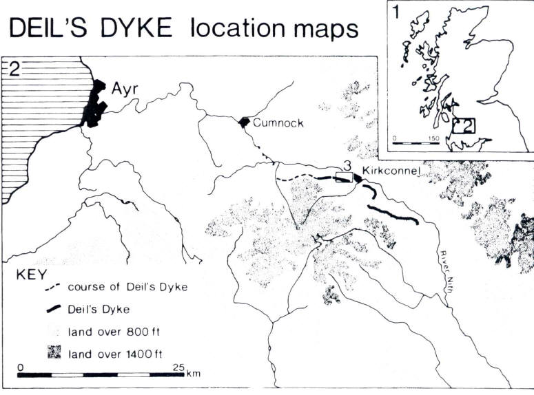

Map of Deil's Dyke Nithsdale
THE DEIL'S DYKE
Nithsdale