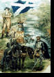
Timothy Pont and Johan Blaeu
Timothy Pont a young man from near Culross, Fife and a graduate of St. Andrew's University undertook the monumental task of mapping his native Scotland, in the clsoing decades of the 16th century. His manuscript maps would form the basis of the 'Maps of Scotland' in the Atlus Novus (1654)
the work of the Johan Blaeu
, the world-famous Dutch cartogtraphic publisher.
Regrettably, Timothy Pont's original manuscript map of Kyle, that part of Ayrshire in which New Cumnock is situated, did not survive. However, his manuscript map of Nithsdale did survive and this contains a small part of what is now the parish of New Cumnock, including Cumnock Castle.
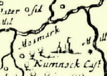
Johan Blaeu's map of Kyle and that of Nithsdale both survive and provide a rich source of place-names that existed in the lands of New Cumnock at the time of Timothy Pont's great endeavour.
PONT & BLAEU
NEW CUMNOCK
© Robert Guthrie
Home
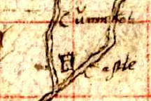
Timothy Pont : Manuscript 35 'Nithsdale; part of Teviotdale'
Johan Blaeu : Coila Provincia, Atlus Novus (1654)