Where is Connecticut
Connecticut: The Constitution State
Atlas ![]()
Where is
Connecticut ![]()
A General Overview of Connecticut
The nation's third smallest state, Connecticut encompasses many different facets of life. Connecticut is highly known for its agriculture, industry, and technology. The state's people also bring home some of the highest incomes in the country. The per capita personal income in the state for 1993 was $27,957 compare this with all of New England, $24,141 and the U.S. at only $20,781. (Department of Economic and Community Development, http://www.state.ct.us/ecd/research/CMD95/cmd95.html : 1995) With well known residents such as Martha Stewart and David Letterman this should come as no surprise!
Connecticut is known all over the world for its defense contractors, as an insurance capitol, and for some fortune 500 companies. The state is an international center for high-tech manufacturing, biotechnology, and pharmaceutical innovations. (Department of Economic and Community Development, intro.: 1996-1997)
The economy has made Connecticut a major exporter with an increased export rate of 8.9% from 1988-1994. This rate is greater than the current U.S. rate of growth. Many federal agencies and private enterprises look to Connecticut for its global access and technological resources. (DECD, intro.: 1996-1997)
Nutmeggers, a name given to Connecticut residents, are very proud to call this small state home. Connecticut residents speak of a high quality of life and heritage when referring to their home state. The late Homer D. Babbidge, Jr. compares our state's heritage to the Yankee stone wall. Stone walls come in many sizes and shapes, "standing out great regularity" or some "eccentric angularity." Different residents posses different heritage's that the state draws on for it's identity. (Phillips, 13: 1992) Connecticut does not have an identity appealing to the masses, like Maine "the vacation state" or Florida "the sunshine state." Our identities are "The Constitution State" and "The Nutmeg State." Neither speak much about the state to people from other places, or its residents.
The name given to this atlas is "The Constitution State Atlas." Why does Connecticut posses this unique identifier? Settlers from the Massachusetts Bay Colony arrived in Connecticut during the 1630's. Hartford's chief founder the Reverend Thomas Hooker preached that settlers should take more active roles in governing themselves, and God gave them liberty so they should take it. This led to the Fundamental orders of 1639, the first written constitution with the principle of self government and the right for people to vote directly for their leaders. The Fundamental Orders have provided the framework for the later U.S. Constitution. Thus, this early document led to Connecticut, The Constitution State. (Guide to Connecticut's State Government http://www.cslnet.ctstateu.edu/lwv/govguide/hist_to.htm )
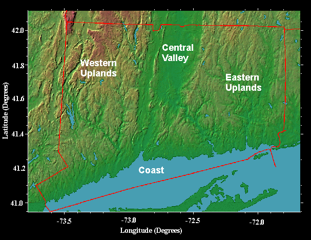
Connecticut contains different landscapes. Slow meandering rivers such as the Connecticut River are found and not too far away are rapid rocky streams such as the Shepaug River. The Central Valley, an area found in the heart of Connecticut and into Massachusetts, provides a wide flat valley home to some of the best cigar tobacco. Tobacco had been a major crop in the state for many years, and recently is becoming major crop once again. Other ravines such as Boston Hollow are narrow and dark. (Bell, 1: 1985)
In Connecticut one can find forested mountains and sandy coasts. (Bell, 1: 1985) One thing to remember though, neither of these terrain's are to any extreme. The state's mountains have been eroded down to large hills, and beaches are usually never more than a mile in length. (Bell, 84: 1985)
Mountainous regions in Connecticut are found on either side of the Central valley, which runs through the middle of the state. The mountainous regions are known as the eastern and western uplands. The eastern uplands are comprised of the Windham Hills with, the Mohegan and Bolton ranges. The western uplands are split between the Northwest hills (generally Litchfield and Fairfield counties), and southwest hills (generally Litchfield, Fairfield, and New Haven counties). (Bell, 7: 1985)
Some interesting
facts of Connecticut commerce
From the Department
of Economic and Community Development
Connecticut Town Profiles
Within 500 miles of CT:
35% of the U.S. effective buying income
68% of the Canadian effective buying income
32% of the U.S. retail sales
67% of the Canadian retail sales
33% of the U.S. manufacturing establishments
76% of the Canadian manufacturing establishments
33% of the U.S. population
68% of the Canadian population
Connecticut offers:
136 newspapers (20 daily)
35 AM and 38 FM radio stations
11 Broadcast television stations
4 major commercial airports

Map Produced and Copyrighted by Ray
Sterner, Johns Hopkins University
http://fermi.jhuapl.edu/states/states.html
Map Source:
Sterner, Color Landforms Atlas of the United States 1995
Bell, The Face of Connecticut 1985