|
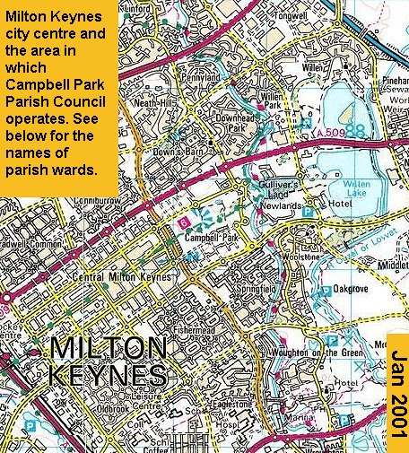
Image produced from the Ordnance Survey
Get-a-map service. Image reproduced with permission of
Ordnance Survey and
Ordnance Survey of Northern Ireland The map scale is 500 meters to each square. For those of you who know the area, you can see how up to date the map is. If you look carefully you can clearly see the shape of the Xscape building in the city centre, just to the north of Fishermead. The parish wards start in the bottom left hand corner of the map. Working from left to right, with Winterhill south (unmarked but to the right of the 'P' symbol between the dark red line and the first yellow). We cross the V6 (Grafton Street) grid road (the first yellow line) to Oldbrook. Thence to Fishermead, Springfield, and the Woolstones. Then up the map to Willen which lies both north and south of the A509 (the uppermost red line - Portway to us). Willen Park is not part of this parish. Left to Newlands (with Gulliver's World marked), and finally, left again to the flagship ward of Campbell Park itself. The next grid to the left is the city centre. Prior to 1986 the parish meeting of Woolstone-cum-Willen controlled virtually everything on the map. There were several thousand fewer residents then. The parish council did attempt to gain control of the eastern half of the city centre just a couple of years ago. Bradwell Parish Council wanted the western half. The central area now has its own Parish Council. Such reviews and changes occur every eight to ten years if deemed necessary by central government. |