The North Region of Thailand
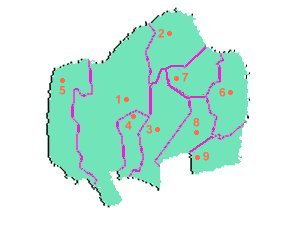
The North region of Thailand has a total area of 93,690.85 sq. km.
and is comprised of 9 provinces which are as follows:
Provinces of North Thailand
 |
|
No. |
Province |
Area (sq. km.) |
Pop. as of 1997 |
|
1 |
Chiang Mai |
11,678.37 |
1,261,138 |
|
2 |
Chiang Rai |
20,107.06 |
1,573,757 |
|
3 |
Lampang |
12,533.96 |
807,362 |
|
4 |
Lampun |
4,505.88 |
408,804 |
|
5 |
Mae Hong Son |
12,681.26 |
229,284 |
|
6 |
Nan |
11,472.07 |
484,116 |
|
7 |
Payao |
6,335.06 |
517,622 |
|
8 |
Phrae |
6,538.60 |
494,637 |
|
9 |
Uttaradit |
7,838.59 |
481,563 |
Geography and Climate
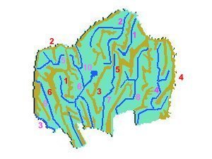
Mountains, rivers and lakes: The North has 6 significant mountain ranges,
9 significant rivers and 1 lake:
Mountains, Rivers and Lakes
of North Thailand
 |
|
Mountain Ranges
|
Rivers and Lakes
|
|
No. (Red) |
Mountain Range |
No. (Purple) |
River or Lake |
|
1 |
Chom Thong |
1 |
Ing River |
|
2 |
Daen Lao |
2 |
Kok River |
|
3 |
Khun Taan |
3 |
Moei River |
|
4 |
Luang Prabang |
4 |
Nan River |
|
5 |
Phii Pan Nam |
5 |
Pai River |
|
6 |
Thanon Thongchai |
6 |
Ping River |
|
|
|
7 |
Wang River |
|
|
|
8 |
Yom River |
|
|
|
9 |
Yuam River |
|
|
|
|
10 |
Kwaan Payao Lake |
Plains: Virtually all of the plains in the North are between the mountain
ranges and have the same name as the rivers that run through them.
Influences on Climate: The North's climate is influenced by the southwest
monsoon and the northeast monsoon winds as well as the depression storms.
Influence from the ocean is minimal due to the distance from the oceans
(500 - 875 km.). The mountains of the North are arranged in a north-south
pattern, and thus do not block the winds. Also the North's high average
altitude (1600 m) contributes to its low temperature.
Temperature: The annual average tempature is 26.5 C, with the average
highest temperature being 28.8 C, and the average lowest temperature being
23.6 C. The highest temperature ever recorded in the North was 44.5 C (Uttaradit
Province, 1960) and the lowest until recent times was 2.0 C (Chiang Rai
Province).
Rainfall: The rain in the North is usually provided by the southwest
monsoon winds and depression storms. On average the annual rainfall in
the North is 1200 mm. The province with the most annual rainfall (recorded
between 1937 and 1955) is Chiang Rai (1744 mm.), the least is Lampun (1045.9
mm.)
Seasons: The North has 3 seasons, the rainy season, from mid-May to
September or early October, when the southwest monsoon winds and depression
storms exert their influence, winter, from mid-October to February, when
the northeast monsoon winds exert their influence, and summer, from March
to mid-May, when the southwest monsoon winds blow heat in from the South.
Places of Interest
The North has many places of interest, for example:
1. Wat Phra That Doi Suthep, Chiang Mai Province
Wat Phra That Doi Suthep is a temple located on
a mountain 11 km. from Chiang Mai town. It is the province's most important
temple.
2. Golden Triangle, Chiang Rai Province
The Golden Triangle marks the point where Myanmar,
Laos and Thailand meet. It was once notorious for the growing of opium
in the area, but this has since stopped due to the Inthanont Royal Project
(below).
3. Doi Inthanont, Chiang Mai Province
Doi Inthanont is the country's highest mountain
at 2,565 m. and is in the Chom Thong Range. The Inthanont Royal Project,
located there, has encouraged the people of the Karen and Meo Tribes to
grow agricultural crops instead of opium.
4. Doi Tung, Chiang Rai Province
Doi Tung has a residence that belonged to the late
Queen Mother Srinakaharinthara, who died in 1995. In front of the residence
there is a large flower garden with various kinds of flowers.
5. Kwaan Payao, Payao Province
Kwaan Payao is Payao Province's most important water
source and is also the North's main source of freshwater fish.
Also, the North has a substantial number of tribal people (about 550,000)
and good trekking trails.
Home | Northeast
| West | Central | East
| South

