|
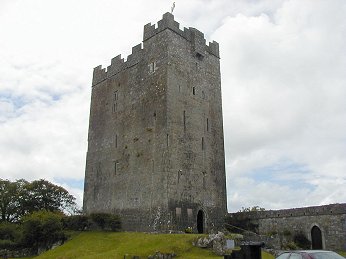
BALLYPORTRY CASTLE
Map Reference: R300902
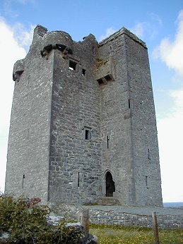
Ballyportry Castle is a large rectangular tower aligned approximately E-W. The castle appears to be five storeys high with
the western end rising to a further storey. It has recently had the higher section pebble-dashed and appears very white. The
doorway in the E wall is protected by a machicolation at roof level. It is set within a very small bawn with two round corner
flankers. The very good crenellations appear to be relatively modern. There are many small window slits, some of which have
round heads, and there are some two-light windows at the upper levels. Some slopstones are visible. The castle was restored
1961-83 by Robert Owen Brown and is now a private residence.
BOSTON CASTLE
Map Reference: R380981
Near Boston there is half a castle standing to full height. Only the north wall with fragments of attached walls still stand.
It appears to be at least four storeys high with some ogee-headed windows. The top storey was lit by a two-light window set
within a round-headed recess. The castle was vaulted above the ground floor and above the second floor. There may have been
a half storey within the thickness of the upper vault. It stands at the north edge of a mound the uppers levels of which presumably
consist of fallen masonry.
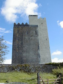
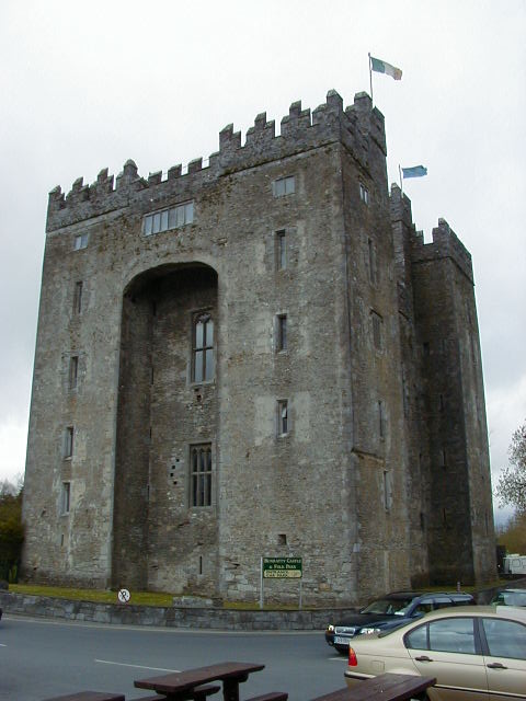
BUNRATTY CASTLE
Map Reference: R452610
In 1277 Thomas de Clare built the first stone castle at Bunratty. The present structure was built about 1460 by the MacNamaras.
Early in the 16th century it was held by the O Briens, who became the Earls of Thomond, and remained in the castle until 1712.
The large three-storey rectangular tower has four corner flankers. The pairs of flankers on the N and S sides are are linked
by broad arches. The original entrance is in the N wall. The ruined castle was purchased in 1954 by Viscount Gort and restored.
Only the reconstruction of the roof and battlements is conjectural.
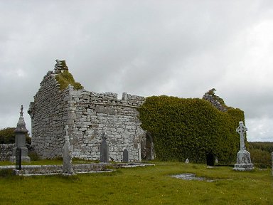
CARRON CHURCH
Map Reference: R240974
Carron Church is a good example of a medieval parish church. A church was built here about 1200 but most of the ruin dates
from the 15th century. There is a south doorway and two good windows in the south wall. The east end of the church is overgrown
with ivy which hides much of the east window. The church had an upper storey at the west end and there are remains of a bartizan
at the northwest corner.
CARRIGAHOLT CASTLE
Map Reference: Q848512
Carrigaholt Castle, Co Clare has a bartizan at the north west corner and is five storeys high. The pointed doorway is in the
middle of the east wall and is protected by a machicolation at roof level and a broad slit above the door leading from the
first floor. The tower is very slim, being only one room thick. The doorway leads to a small lobby which has a long murder-hole
in the roof. There is a rectangular room to the right and to the left is a broad passage which leads to a broad spiral stairway
in the south west corner. The castle is locked and the upper levels coud not be explored. There was a building about three
storeys high plus attic attached to the south wall near the eastern corner. This has now been removed perhaps because most
of the ground in this area has fallen into the sea. The castle is surrounded by a later bawn with a small round turret at
the north east corner.
CORCOMROE ABBEY
Map Reference: M2954090
Corcomroe Abbey, in Abbeywest, has a long rectangular church divided by a thick
wall surmounted by a slim tower. The pointed west doorway is surmounted by two tall lancet windows. At the east end there
is good vaulting and the three lancet east windows are surmounted by a single small lancet. On the left is a possible double
sedilia with decorated columns. Beside this is a tomb-niche with a recumbent figure. This is the effigy of Conor na Siudaine
O Brien, one of the abbeys great benefactors, who died in 1267. Opposite it is another decorated double sedilia. The chancel-arch
has columns with decorated capitals and bases. There were north and south aisles but only the south aisle has any remains.
The church had short transepts with small east chapels. There are excellent wicker-marks in the south chapel. The cloister-garth
is to the south of the church but there are no remains of the arcade. There is a stringcourse on the east gable level with
the window tops and at each corner is a little dog facing downwards. The abbey was called Sancta Maria de Petra Fertili (St
Mary of the Fertile Rock) and may have been founded by Donal Mor O Brien in 1182. However it is more likely that it was colonised
by monks from Inislounaght under the patronage of his son, also Donal, in 1195. After the Dissolution it passed through various
Thomond and O Brien hands until Richard Harding acquired it in 1611.
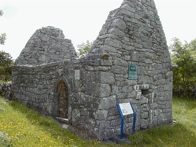
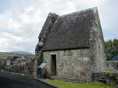
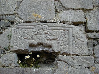
TEMPLE CRONAN
Map Reference: M288000
Temple Cronan is dedicated to St Cronan of Roscrea or Tuamgraney. This small rectangular church possibly dates from the 12th
century. There was a simple lintelled west doorway with inclined jambs. This is now blocked and a pointed north doorway was
inserted in the 15th century. The church had a high pitched roof with decorated corbels at the corners. There are several
masks built into the walls. Close to the southeast corner is a tomb made from two large slabs leaning together and two triangular
end panels. To the northeast is a similar, though smaller, tomb.
DRUMCLIFF CHURCH & ROUND TOWER
Map Reference: R239801
At Drumcliff there is the ruin of a small church and the stump of a Round Tower. Nothing is known about the history of the
early monastery but the site is associated with St Conald. The church has a two-light east window with ogee heads and a round-headed
west window set within a deep recess. This may have been taken from an earlier church. There is a pointed south doorway. The
Round Tower stands to about three storeys plus basement but most of the wall in the region of the doorway is missing. The
most remarkable thing about the graveyard is the number of large tombs. There must be in excess of 30. They seem to date from
the second half of the 19th century. Some of them have a pedimented front or a cornice hiding the pitched roof. In at least
one of them the doorway is flanked by pilasters. At least two were used in the last 30 years. It is a remarkable collection
and it seems you have to be rich (and dead, of course) to get into Drumcliff cemetery.
DYSERT O'DEA MONASTIC SITE
Map reference: R282848
Dysert O Dea Church stands on the site of an Early Christian monastery, which was founded by St Tola who died about 735. The
long nave-and-chancel church has a long round-headed west window, a plain chancel arch and three lancet east windows. There
are also small lancet windows in the north and south walls. The crowning glory of the church is the magnificent Romanesque
south doorway. This has a four-order arch. The outer order is masks, both human and beasts. The second order has a triangular
serrated structure. The third order has a cusped or scalloped appearance. The inner order has some zigzag decoration with
small inverted masks at the ends. The inner flat surface of this arch has diamond panels with foliage in the centre. The capitals
of all the columns are richly carved. The two capitals of the outer order have human masks with intertwined hair and beards.
In the third order the capitals are horned beasts. The columns are all richly decorated with a variety of motifs. The doorway
dates from the 12th century and was inserted in its present position when the later church was built. To the north west of
the church is the stump of a Round Tower with a fine round-headed doorway. To the east of the church is a very fine High Cross.
On the west face there are patterns and some intertwined beasts. There are also beasts on the two narrow edges. On the east
face there is a Crucifixion in high relief and also the figure of a cleric holding a crozier. This is probably St Tola. There
is an empty socket, which may have held the right arm of the cleric, which would have been raised in benediction.
ENNISTYMON MARKET HOUSE
Map Reference: R132888
Ennistymon Market House is a five-bay single-storey building including two doorways with a louvered dormer above each doorway.
GLENINAGH CASTLE
Map Reference: M193103
Gleninagh Castle is an L-shaped building with a spiral stairway in the narrower
east section. The doorway, within the angle of the L, is protected by a wall bartizan. The tower is four storeys high with
round bartizans at three corners. It is vaulted above the second floor and an underground vault supports the ground
floor. There are many corner defensive slits as well as other slits and two-light windows. This is an O Loughlin castle, which
was occupied until 1840. Nearby is a Holy Well.
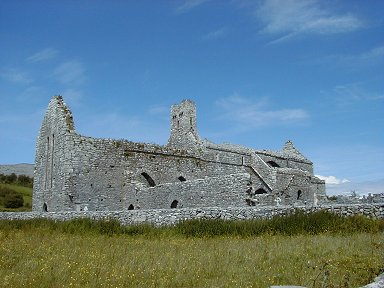
KILFENORA CHURCH & CROSSES
Map Reference: R183940
Kilfenora Cathedral is on the site of a monastery founded by St Fachtna. Little is known of its history but it was burned
in 1055 by Murtough O Brien. Parts of the present church date from the late 12th century. The west end is still in use but
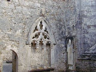
the east end is ruinous. It contains three effigy slabs and a triple sedilia with a decorated hood. The three-light east window
has some decoration. Just to the west of the church is the Doorty Cross, a ring-headed cross with figure sculpture in high
relief. A short distance northwest is another cross with interlacing. About 100m to the west is a tall slender cross with
a Crucifixion on the east face and a variety of geometrical and interlaced ornament elsewhere.
KILLALOE CATHEDRAL
Map Reference: R705729
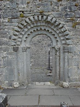
An early monastery was founded at Killaloe, Co Clare by St Fachnan. He was succeeded by St Flannan who died in 639. Killaloe
Cathedral was founded about 1185 by Donal Mor O Brien on the site of an earlier church. The Romanesque doorway from this church
is preserved in the southwest corner of the Cathedral. It is a four-order arch, richly decorated. The outer arch has a continuous
bead-bordered chevron roll. The second arch has chevrons alternating point-up and point-down. The third arch has carvings
of heads and animals but is greatly damaged and the inner arch has chevrons alternating and connected by curved rolls. The
abaci are greatly defaced and the capitals below them are scalloped and decorated with animals and foliage. The first and
third jambs are square in plan and are deeply carved with chevrons and notches. The second jambs are round and are delicately
carved with lozenges and zigzags. Only part of the inner jamb remains. Every unmoulded space in the doorway is decorated with
a variety of foliage and animals, over 130 of them, no two quite the same. Close to this doorway is a stone with a Runic and
an Ogham inscription on it. There is also a decorated font and a High Cross, which was moved to the Cathedral from Kilfenora.
It is similar in appearance to the Doorty Cross but it is less complete and the carvings are not as deep.
ST FLANNAN'S ORATORY, KILLALOE
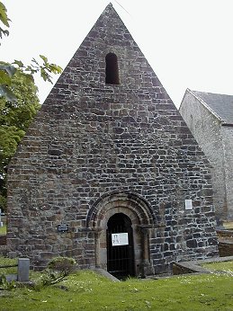
Beside Killaloe Cathedral is St Flannan's Oratory or Brian Boru's Vault. It is the nave of a small 12th Romanesque church,
which has lost its chancel. It has a round-arched three-order west doorway. The capitals of the jambs have animal and foliage
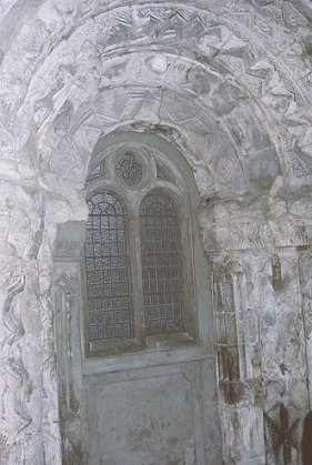
decoration. The church has a barrel vault above which is a croft with a pointed corbelled vault. The croft is lit by a round-headed
window in the west and an angle-headed window in the east. There is a plain chancel arch. The nave has an angle-headed south
window.
ST LUA'S ORATORY, KILLALOE
Map Reference: R701729
Beside the Catholic church is St Lua's oratory, a small nave and chancel church, removed from Friar's Island in River Shannon
ahead of flooding in 1930. The nave is fragmentary with lintelled west doorway. It originally had a wooden roof. There is
a plain chancel arch. The chancel has high-pitched stone roof and round-headed east window with a stepped round-headed recess.
There is a south doorway.
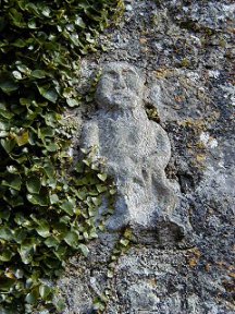
KILNABOY CHURCH
Map Reference: R271916
Kilnaboy Church is a medieval church dating from the 16th century and probably earlier. It was repaired in 1715. The large
rectangular church has a large cross-of-Lorraine detailed in raised stonework on its west gable. This probably dates to the
early 13th century. There is a good sheila-na-gig above the south doorway. Just inside the door one of the stones forming
part of the left jamb has a grotesque carving, possibly another exhibitionist figure. The mullioned east window has four lights
below the transom and a traceried three-light section above. There is a plain tomb niche in the north wall with a triangular
hood. The tomb niche in the south wall has a Crucifixion dated 1644 and a raised letter inscription. There are two large pointed
windows in the south wall. One of the gravestones within the church shows a small figure holding a trident. Is this possibly
a rare depiction of the Devil on a gravestone? Just to the north of the church is the overgrown stump of a Round Tower.
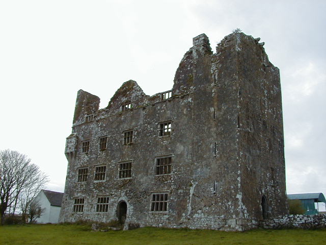
LEAMANEH CASTLE
Map Reference: R235935
The eastern portion of Leamaneh Castle is a five storey tower built about 1480. It is vaulted above the top storey. It contains
a spiral stairway and a vertical arrangements of small chambers lit by narrow defensive loops. Some of these small windows
have slop-stones. Some of them also have hinge-stones for window shutters. Some of the windows in the N wall have ogee heads
and decoration. The doorway in the E wall was protected by a machicolation and a murder-hole. The western portion of the castle
is a four-storey four-bay mansion with many mullioned windows. There is a projection at the Nw corner and a doorway in the
middle of the S wall. There is a wall bartizan at the Sw corner accessible from the first floor. The mansion was built in
the 1640s. Remnants of the large surrounding bawn can be seen on both sides of the road.
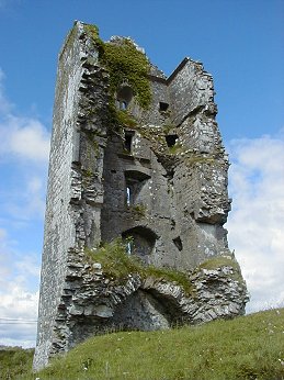
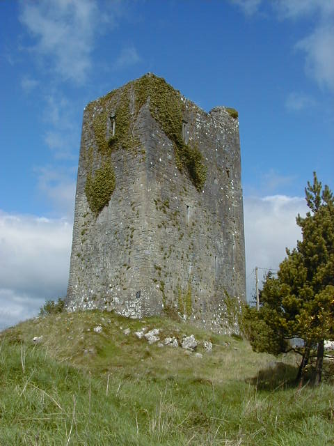
MOUNTCASHEL CASTLE
Map Reference: R476689
Mountcashel (or Ballymulcashel) Castle was built by Conor na Srona O Brien, King of Thomond, in the second half of the 15th
century. It stands on top of a rocky outcrop and was lived in until recently.
NEWTOWN CASTLE
Map Reference: M217064
Newtown Castle is a round castle on a pyramidal base. There are remains of four
machicolations at roof level. The doorway is in the base of the east wall and there are some two-light windows. To the right
of the doorway is a small guard-chamber. Ahead is a large circular vaulted room with very good traces of wicker cantering.
There are no obvious window openings. The entrance to this room is through a door at the base of the stairs. A curving mural
stairway rises to the left. It very quickly changes to a spiral and ascends to roof level. The stairwell intrudes into the
rooms at each level. There is another vault above the second floor. The levels above each vault are lit by many windows. A
chimneystack rises in the north wall. The castle is five storeys high.

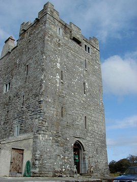
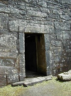
O'DEA'S CASTLE
Map Reference: R283850
O Dea's Castle has been fully restored and is now a museum and exhibition centre. It is possibly five storeys high. There
is a guard chamber to the right of the entrance and a very fine spiral stairway rises on the left. The entrance is protected
by a murder hole leading from the first floor and a machicolation at roof level. The castle is vaulted above first floor and
third floor. At the second floor there is a good collection of fashioned stones including quern stones and millstones. At
the third floor there is a good AV display illustrating the history of Co Clare. The room above the second vault has a fine
fireplace. There is a three-light window in the west wall and a two-light window in the south wall. Much of this appears to
be a reconstruction. The room houses a fine collection of archaeological finds. The roof and crenellations are modern.
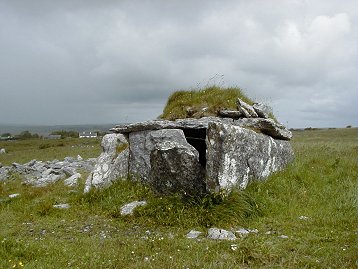
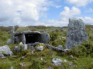
PARKNABINNIA WEDGE TOMB
Map Reference: R265935
Parknabinnia Wedge Tomb is another box-like structure but simpler than the tomb at Tullycommon. There are two long side stones,
a back stone, a broken door stone and a large flat capstone. The capstone is covered with rubble and sod.
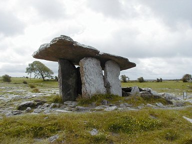
POULNABRONE PORTAL TOMB
Map Reference: M236004
Poulnabrone Dolmen is a very simple structure. There are three stones on each side, a back stone and a low door stone. A large
capstone covers the burial chamber and there is a smaller capstone now resting at he rear, out of position. It is surrounded
by a low cairn of stones which may be all that remains of a covering cairn. Excavations revealed the disarticulated bones
of 16 adults and children.
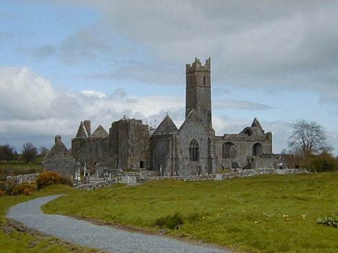
QUIN FRANCISCAN FRIARY
Map Reference: R419745
Quin Franciscan Friary was founded by either Macon or Sioda Cam MacNamara in 1433. The pointed west doorway is surrounded
by a square mould and topped by a large two-light window. There is a south transept with a three-light south window, two two-light
east windows and a two-light west window. There is a piscina with a double basin in the south wall. This is somewhat enigmatic
in that one of the columns of the piscina encroaches on one of the basins, which are octagonal. There is a plain tomb niche
in the north wall of the nave. In the south wall is a deep Holy Water stoup, which has an octagonal basin and a vaulted covering.
A tall central tower rises to three storeys above the crossing and has a very fine vault. There is a three light east window
in the chancel. In the northeast corner is a tomb with a canopy supported by four pillars. There is a two-light south window
and another tomb niche in south wall. The cloister is to the north of the nave. It is intact with arcade and vaulted walks.
There are good wicker marks in the vault. The arcade has the usual dumbbell-shaped pillars in groups of two with a buttress
at each division within the cloister garth. There are two-storey buildings along the west, north and east of the cloister.
They have very fine vaults. Those in the north and east have fireplaces. In the west range there is an inserted mausoleum
of the Butler Family. The upper storeys of all these buildings are accessible, as is the passage, which runs along the north
side of the cloister. The friary sits on the foundation of an early castle, which had four large round corner towers. Traces
of these can be seen particularly from the upper levels of the friary. This castle was built in 1280 by de Clare but was destroyed
early in the following century after the garrison killed an Irish chief called O'Liddy. A short distance to the west of the
friary is the rectangular ruin of St Finghin's Church (R417744). It was built between 1278 and 1285 and a tall slim tower
in the southwest corner was added later. The north wall is missing and the east wall has a good triple lancet. There are two
narrow lancets in the south wall. To the south of the church is a mausoleum to Captain William Spaight who died June 7 1801.
RATH CHURCH
Map Reference: R270857
Rath Church was a nave and chancel church but most of the chancel is now gone. Only the south wall remains. It had a pointed
chancel arch. The main feature of the church is a fragment of a decorated window surround. This features a small carving of
a sheila-na-gig, now set upside down. There is also a mitred head set into the south wall. At the south doorway is a plain
but deep holy water stoop and another decorated panel. The carving is very shallow and worn and the theme of the decoration
cannot be identified. The site is associated with St Blathmac, a 6th century saint, who is believed to have been a teacher
of St Flannan of Killaloe. In the 12th century Rath was an important centre of learning supported by the Ui Bhriain kings.
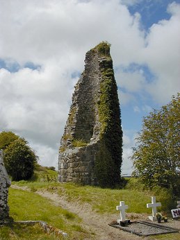
The remains of a Round Tower stood to the west of the church but it was demolished in 1838 and some of the stones were built
into the graveyard wall.
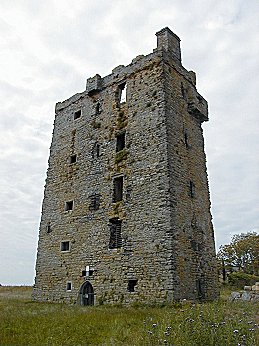
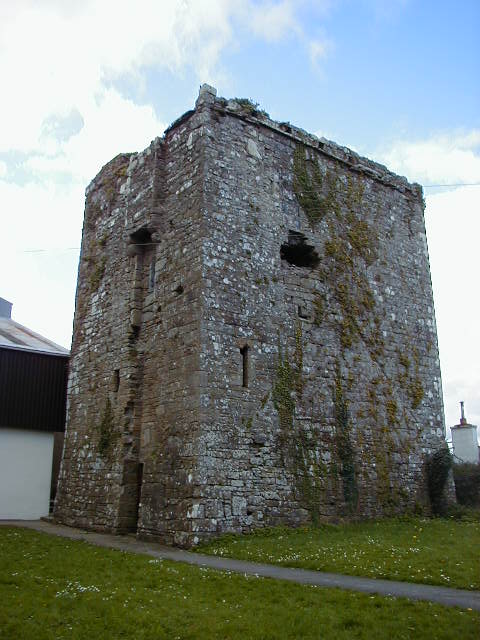
SMITHSTOWN CASTLE
Map Reference: R148941
Smithstown Castle has now been fully restored. It appears to be about five storeys high. The top storey is a complete restoration
with false bartizans and machicolation. There is a pointed doorway in the east wall and a spiral stairway rises on the left.
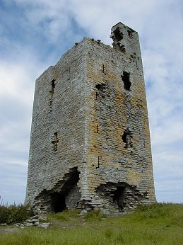
TROMRA CASTLE
Map Reference: R008732
Tromra Castle, Co Clare may have had the entrance in the south wall but this section of the building is badly damaged. A mural
stairway rises within the south wall and continues within the east wall. The castle was vaulted above the ground floor and
again above the first floor. There seems to be two more storeys above the second vault. A small turret rises above the north
east corner and there may have been a bartizan at the south east corner where there are some corbels.
TUAMGRANEY CASTLE
Map Reference: R638828
The doorway of the castle is protected by a good machicolation. There is a vault above the first floor with marks of wicker
centering. A broad spiral stairway leads to roof level but is missing above the first floor. A small rectangular room may
be reached from the stairway. It leads to the first floor room (floor missing) beyond which is apparently another small chamber.
The rectangular chamber leading off the stairway has two small windows.
TUAMGRANEY CHURCH
Map Reference: R637830
An early monastery was founded at Tuamgraney by St Cronan who was Abbot of Clonmacnoise
and died there in 638. It was plundered in 886 and 949. Cormac O Cillin who died in 966 built the great church and tower.
The western portion of the present church, with its lintelled doorway, may date from his time. The eastern part of the church
dates from the 12th century. It has round corner pilasters with decorated capitals. High up on the east gable is a weather
mask which is said to represent St Cronan. The church is now the East Clare Heritage Centre.
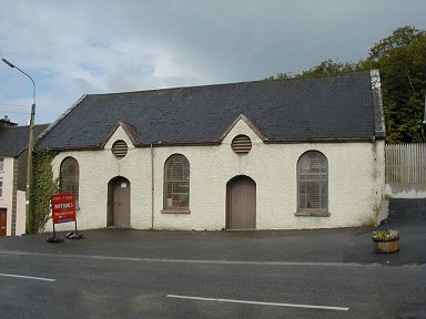
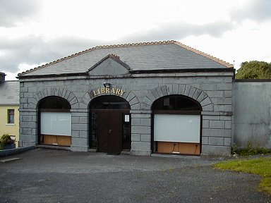
TULLA MARKET HOUSE
Map Reference: R493798
Tulla Market House is a three-bay single storey building now the local library. It was built by Thomas Browne of Newgrove
in 1843.
TULLYCOMMON WEDGE TOMB
Map Reference: R273958
Tullycommon wedge Tomb is aligned approx SW-NE. It is a box-like structure with two long side stones and a capstone. At the
rear two shorter side stones flank the back stone. Just beyond the end of the chamber is an outer back stone and the outer
wall is well represented on both sides. There are several facade stones in place.
|