
|
History of the Parish
of New Cumnock
by Robert Guthrie
.........
|
|
NEW CUMNOCK
|
|
In the summer of 1937, Alexander G. McLeod and a number of his associates excavated two bronze age burial sites in
the parish of New Cumnock. The first was discovered close to the side of the New Cumnock to Dalmellington road, across from the Beoch road-end, and has since been referred to as the Beoch Cairn. All the relics discovered during the excavation were presented to the National Museum of Antiquities of Scotland and are now in the care of the Trustees of the of the National Museums of Scotland (NMS). The Trustees have kindly given me permission to use photographs of these relics on www.new-cumnock.co.uk. |


|
EXCAVATION OF TWO BRONZE AGE BURIAL SITES IN AYRSHIRE.
BY ALEXANDER G. McLEOD, M.A., F.S.A. SCOT.
Proceedings of the Society of Anitquaries of Scotland, 72, 1937-1938,241-247
'In the course of frequent journeys with me to Loch Doon via New Cumnock and Dalmellington to explore the ruins of
the mediaeval dwellings on Donald's Isle, Mr Archibald Fairbarin of Wellwood used to scan the surrounding moorland for traces of ancient monuments, and one day his observant eye noted a prominent upright stone at the top of a slight elevation in the rising ground close to the main road on the left. We proceeded to the spot and observed that several large stones (fig. 1), and that within the circle the grass was short and green, whereas all around the moorland grass was long and white. In the following summer of 1937, having obtained permission form the tenant-proprietor of the sheep-farm, Mr Hamilton of Maneight, on whose land the stone circle was situated, we carried out a detailed investigation. In addition to Mr Fairbairn and myself, the late Mr William McIntyre, F.S.A. Scot., Cronberry, and Mr James Mair, Cronberry, took an active part in the work of excavation.' |
|
'The site of the stone circle and burial cairn is on high ground 40 yards south of the road from New Cumnock to
Dalmellington, at a distance of 3 1/2 miles from Dalmellington and 7 1/4 miles from New Cumnock, at an altitude of 1053 feet above O.S. datum (O.S. Sheey XLVII.). The stone circle is surrounded by bare moorland, through which project many large boulders of granite. South-west of the cairn site are the remains of an old fail dyke, At a distance of 140 yards to the south-east are the foundations of a steading, and farther to the east is a large rectangular sheep- fold, containing in its walls, doubtless, many stones from the vanished cairn.' |

|
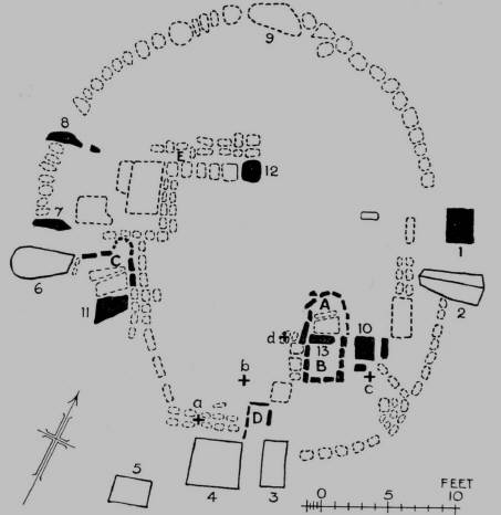
Figure 1:
Stone Circle at Beoch, Ayrshire
|
|
Figure 2:
Plan
|
|
Place cursor over the
coloured dots to read A.G. McLeod's notes |
|
stones
|
|
urns, bones
|
|
cists, pits
|
|
A. G. Macleod gives a detailed descriptions of each of the major stones in the circle and these are included in the
coloured dots on the plan above. He also observed that 'in line with stones 12 and 9 , two more stones appear above the turf beyond the circle towards the road at intervals of 10 feet.', The account of Beoch Cairn continues..
'A trial section was first opened north-west of the centre, near stone 12, where there was a large depression. On the
removal of the thin surface layer of turf, a compact mass of assorted stones was revealed. No regular plan was disclosed, but large boulders lay in confusion where they had been thrown when the cairn was disturbed. Later this test section was extended southwards beyond the centre, and at the place marked + b on the plan, some burnt bones and scattered fragments of probably three cinerary urns were encountered among the blackearth of a fine texture between the boulders. One of these had been made of a red clay intermingled with grains of crushed granite. So far as can be ascertained, it has had a diameter of about 9 1/2 inches at the mouth, the lip being flat with slightly rounded edges. There has been a slight shoulder, and from the lip downward the vessel has been decorated externally with an incised lattice pattern, but how far this pattern extended beyond the shoulder it is impossible to say. What may be a second vessel, of which only two small fragments of the wall remain, shows decoration consisting of circular markings impressed on the soft clay by means of a hollow bone or reed. The third vessel is represented by small fragments only of what was probably a cinerary urn of rather coarse clay.' |

|
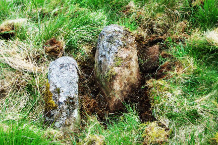
The ground west of the prominent pillar-stone 10 appeared less disturbed, and a line of stones at surface level was
suggestive of rough masonry. Accordingly this region was next stripped of its turf and cleared of loose boulders and black earth. On the northern side of stone slab number 13 was disclosed a cist, A, partially paved with two flat stones, at a depth of 1 foot and bounded on its western and northern side by a line of stones on edge, inclined inward and firmly held in position by an external retaining wall (Figure 3). At the northern end, 3 feet 3 inches from the stone slab, a pit was exposed filled with black earth to the depth of 2 feet. The eastern side of the cist had been disturbed |
|
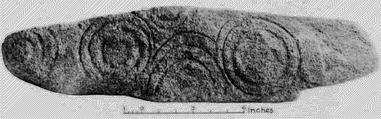
Lying on the floor was a narrow dolerite block (Figure 4.) 1 foot 11 inches long and triangular in section, two faces being
7 inches wide and the other 5 1/2 inches. On the narrow face are two sets of concentric rings, and between them three arches, the upper arch joining with the outer ring of each set, the second arch emerging with the outer ring of the set on the left, while the lower arch stands alone. On the edge of the stone above the arches is another incomplete set of rings, and at the extreme end of the block are three incomplete rings with a central boss, which appears to have marks of pecking. All the rings have probably been incised, although the natural wear and roughness of the stone makes this a little uncertain. The block is probably a fragment of a larger stone.
Another unpaved cist, B, was uncovered on the southern side of the slab 13, 2 feet 6 inches square and entirely enclosed
by lines of stones. It contained black earth, but neither burnt bones nor fragments of pottery. Beyond the western wall of this cist were found three flat stones lying horizontally a foot beneath turf-level. A few irregular flat stones formed a continuation of the line of slab number 13. When they were removed , a heap of burnt bones was disclosed lying among balck earth and small fragments of charcoal upon a flat stone slab, beneath the stone marked + d on the plan. The excavation was extended south of the pillar-stone number 10, where the fragments of a different type of urn, thicker, coarser, and darker in colour were found at + c. South-east of the pillar-stone a compact portion of the kerb was exposed. The ground between stones 3 and 4 was also excavated , and the excavation continued towards the centre, disclosing five flat stones set on edge, enclosing a pit, D, full of boulders and black earth. |
|
Figure 3:
Cist A. Beoch Stone Circle
|
|
Figure 4
Ring-marked Stone
from Cist A.
|
|
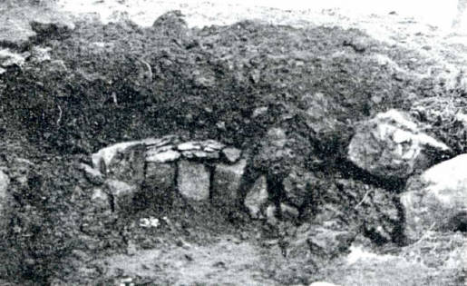
Figure 5:
Cremation Pit
Beoch Stone Circle
|
|
Attention was next directed to the northern portion of the south-western quadrant between stones 6 and 11, and
around the latter stone, which protruded 1 foot above the surface. The area between this stone and the large prostrate stone number 6 was partly paved at the depth of 1 foot with a long flat slab, 2 feet 9 inches long, from 7 to 8 inches thick, and from 1 foot to 1 foot 4 inches wide. This slab had parallel smooth sides, and appeared, like slab 13, to be part of the walls of a cist. It had probably been thrown down when the cist was disturbed. This area was enclosed on the east and north by lines of stones, at the junction of which, 3 feet 6 inches from stone number 6, and 4 feet 6 inches from pillar-stone number 11, we exposed a semicircle of six flat slabs, of an average width of 9 inches and 1 foot 4 inches high, all set on end and wedged closely together. They partly enclosed a small pit (Figure 5.), 18 inches in diameter and 2 feet deep, paved with three small flat stones. Upon these stones lay a heap of burnt bones, surrounded by black earth, but neither charcoal nor pottery was found in the pit. Some of the vertical stones were made up to the uniform height of 1 foot 4 inches by courses of small flat stones, as if it were the intention to cover the pit with a slab or slabs, but no cover-stone was found.
Excavation was now carried northwards as far as the line from stone number 8 to stone number 12. A large flat stone, 3
feet by 2 feet , was uncovered in line with stone number 7, and 2 feet inwards were exposed two adjacent inclined flat stones, one 3 feet by 1 foot, and the other 4 feet by 2 feet 6 inches, both of which were 1 foot thick. Beyond the larger of these stones a line of large of large boulders extended up to stone number 12 , and immediately behind it was found a double line of small boulders , placed end to end , turning sharply at right angle south of the large inclined stone and supporting the semicircular structure. North of the line of large boulders ending at stone 12 and at an average distance of 1 foot from it, extended an irregular parallel row of stones. At one point in the narrow passage between these rows, three large stones with flat faces partly enclosed a space, E, which on excavation, yielded nothing but black earth.
The remaining portion of the south-west quadrant was next excavated , and it was discovered that the inner row of the
double line of stones east of stone number 11 was continued south-eastwards. Another double line of stones was exposed parallel to the inner edge of the prostrate square stone 4. In the course of the removal of this row of stones, fragments of pottery were found at a distance of of 1 foot 8 inches from the north-west corner of stone number 4, at the point marked + a. It consisted of the base and wall fragments of a small vessel of reddish clay, probably a beaker urn. A small portion of the rim , which survives , shows that the lip was bevelled slightly to the inside. Externally, the vessel has been decorated from lip to base with small punctulations made with a pointed tool, those near the lip and at the bottom in parallel horizontal lines, but on the body with irregularity. The wall of the vessel is 5/16 inch in thickness. And the diameter of the base is 3 1/8 inches. The external diameter at the mouth may have been 5 inches, but the fragment of rim is so small that an accurate estimate cannot be made. The fragments lay along black earth, but no trace of burnt bones or charcoal was observed in the vicinity. The remainder of the base of the cairn was stripped of turf, but not further explored, as no sign of internal structure was revealed. A semicircle of boulders at the kerb on the northern side was laid bare. |
|
© The Trustees of the National Museums of Scotland
(Please See Copyright Notes below)
|
|
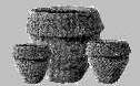
Beoch Cairn : Decorated Stone and Fragments of Cinerary Urns
|

|
Decorated Stone (top) : Although the Beoch Cairn is a kerbed burial cairn typical of Early
Bronze Age c.2000 BC - c.1600BC, the decorated stone is of greater antiquity, probably from c.3000 BC - c.2500 BC . This phenomenon is known from several Bronze Age sites. It may have been part of the family regalia, marking out the grave of someone of relatively high status. |
|
Urn fragments (left) : Made of red clay intermingled with grains of crushed granite, to prevent
the clay pot from breaking during firing. An incised lattice pattern, probably created using string, is evident on the collar of the urn. It is estimated to have a diameter of 9 1/2 inches. |
|
Urn fragments (front left) : Two small fragments of the wall of an urn, showing ciruclar
marks, created using a hollowed reed or a bone. |
|
Urn fragments (middle ) : Made of a rather coarse clay, calcined bones are spread throughout
these fragments. |
|
Urn fragments (right) : Small vessel of reddish clay, probably a beaker urn. The wall is 5/16
inches and the diameter of the base is 3 1/8 inches, and the external diameter at the mouth may have been about 5 inches. The vessel is decorated with regular lines of small holes, created using a small bone comb. |

|
Alexander G. McLeod's account of the excavation of the Beoch
Bronze Age burial cairn, is presented in the Proceedings of the Society of Antiquaries of Scotland, and is reproduced here with due acknowlegement. |
|
The beaker urn, the fragments of which were discovered near the prostrate square stone numbered 4, may have
originally lodged in cist D. The lines of stones, laid end to end on the eastern and northern sides, served as walls of cist C. Probably the fall of the stone number 6 would have destroyed the western wall of this structure. The large stone slab found on the floor, so remarkably similar to stone slab 13, may have discharged a similar function. The two distinct remaining lines of stones probably preserved the remarkable semicircular stone structure at their junction, half - enclosing the cremation burial-pit. The line of large boulders extending to stone 12, and the inner line of smaller boulders at right angles to the above line and extending along the edge of the large inclined stone, may have been two sides of another rectangular enclosure, but the other sides were not discovered, the base of the cairn being greatly disturbed in this area - a decided depression at the surface revealing the extent of the disturbance. If, as seems probable, this area were the site of another cist, then all three inner stones, 10,11, and 12 would be associated with cists
Neither flint artifacts nor cores were found, nor were any weapons or personal ornaments of bronze dicovered.
Neither was the site of the actual cremation.
The excavating party desire to place on record their grateful thanks to Mr Andrew Hamilton, Mr John Smith, and Mr
John Graham for their helpful advice and friendly interest in the work of the excavation and to Mrs Christie (Waterhead estate - Nith Lodge Cairn) and Mr Hamilton (Maneight - Beoch Cairn) for kindly presenting all the relics discovered to the National Museum of Antiquities of Scotland. |
|
The cairn site seem to be family burial-grounds of the
Bronze Age, and exhibit a ring of standing stones around the periphery. Some of the standing stones are clearly associated with the burials. In the case of the Beoch cairn-site nothing was found below the undisturbed clay floor, no incinerated bones nor fragments of cinerary urns were found within the two eastern cists , A and B. But the horizontal paving- stones on the floor of cist A seem to suggest that they were intended as bases for cremation burials, while the flat stones found lying beyond the western edge of cist B may have been placed originally on its floor to serve a similar purpose. The three cinerary urns , the fragments of which were discovered not far from the walls of cist B, may have been in the cists when the latter were opened , the urns broken , and their fragments scattered.. These urns would be crushed under the weight of the cairn, unless they had been placed in cists protected by heavy cover-stones. |

|
The remains of this prominent kerbed cairn are situated in moorland at a height of 1053 ft OD. Measuring 11.0m in
diameter and 0.5m maximum height, it was excavated by McLeod in 1937, revealing at least three cists of which a double one wall still exposed in 1954. Part of a beaker of indeterminate type, and fragments of three cinerary urns found as well as a ring-marked stone. In line with two stones in the cairn, two more stones protrude through the turf between the cairn and the road. The site had been disturbed before excavation and large stones now lie scattered over the area. The finds are in the NMAS (Acc Nos: EP 51-5).
A G McLeod 1938; D L Clarke 1970; A Morrison 1968
Visited by OS (JLD) 16 July 1954
The remains of this cairn are as described by the previous authorities. The two stones beyond the cairn are of no
apparent significance.
Surveyed at 1:10,000.
Visited by OS (BS) 28 May 1976
The cairn is now bordered on the N and W sides by afforestation. Forestry ploughing has displaced a number of the
stones; however, the double cist and the general outline of the kerb can still be identified.
Visited by OS (MJF) 19 September 1980
|
|
Location
Map reference: NS 522 084
Parish: New Cumnock
Council: East Ayrshire
|
|
Archaeology Notes
NS50NW 1 5222 0844.
(NS 5222 0844) Cairn (NR) (remains of)
OS 1:10000 map (1978)
|
|
BEOCH
Type of Site: Cairn
NMRS Number: NS50NW 1
|
|
Subsequent visits to the Beoch Bronze Age Site have been recorded by the
Royal Commission on the Ancient and Historical Monuments of Scotland (RCAHMS) and are reproduced here with due acknowlegement . |
|
The Beoch Bronze Age Burial Cairn
The site is on the lands of Maneight,
about 1 mile to the west of Maneight hill a name which is derived from the Welsh mynaich Gaelic manach 'monk'.
A holy place on an ancient burial place.
|
|
SOURCES and ACKNOWLEDGEMENTS
|
|
Dr Alison Sheridan, Department of Archaeology, National Museums of Scotland
Many thanks to Dr. Sheridan for taking the time to show me the Beoch relics at the NMS, for sharing her expert
views and for her encouragement.
Helen Nicoll, Picture Librarian, National Museums of Scotland
Many thanks to Helen Nicol for providing such high quality images and for her support and guidance.
The Trustees of the National Museums of Scotland
For permission to reproduce the image of the Beoch Cairn relics © The Trustees of the National Museums of Scotland
Any form of reproduction , transmission, performance, display, rental, lending or storage in any retrieval system without
the written consent of the copyright holders is prohibited.
Downloading of images for use by third parties and End Users is srtictly prohibited, except for private study.
Downloading of images for commercial purposes will be treated as a serious breach of copyright and strong legal action will be taken by NMS.
The Society of Antiquaries of Scotland
Acknowledgement for reproducing the article from the Proceedings of the Society of Antiquaries of Scotland
The Royal Commission on the Ancient and Historical Monuments of Scotland (RCAHMS)
Acknowledgement for reproducing from Canmore database, RCAHMS
|