The Seismic Safety Zone
For the most part the Denali fault is a strike slip fault, but there are some areas in the eastern segment that appear to be thrust faulting. The Denali fault extends 750 miles from southeast to south central Alaska. The moment tensor solutions indicates that this quake was a strike slip with most of the aftershocks propagating towards the east.
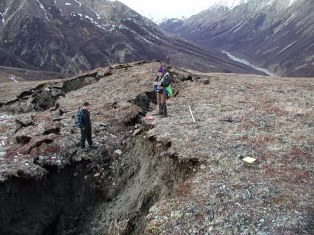
Photo Courtesy of Peter Haeussler
U.S. Geological Survey
Not obvious to the casual observer, the trench of the Denali fault cuts through the heart of the Alaska Range and is more than obvious in photographs taken from high-altitude aircraft or satellites.

Photo Courtesy of Peter Haeussler
U.S. Geological Survey
It is known that there has been major westward displacement of the land on the south side of the fault relative to that on the north. The highest estimates of the displacement give a figure of 250 miles during the past 60 million years. Over this time span, this averages out to a motion of about 2 feet a century or six-tenths of a centimeter per year. Thus, instead of being where it is now, Mt McKinley--if it existed about 60 million years ago--would have been in eastern Alaska, not far from Tok, since Mt. McKinley sits just on the south side of the Denali fault.
The quake, centered on the Denali Fault 90 miles south of Fairbanks, struck Sunday at 1:12 p.m. Alaskan Standard Time (5:13 p.m. EST) its effects strongly felt in Anchorage about 270 miles to the south. It lasted at least 30 seconds.

Photo Courtesy of Peter Haeussler
U.S. Geological Survey
A series of aftershocks shook the region Sunday and early Monday, and seismologists said more could be expected for the next several days. The largest aftershock measured magnitude 5.1, and one of 4.5 hit early Monday.
"This earthquake was shallow (3.1 miles) and the energy went directly into the surface. A quake of this size can be felt for many 100's of miles and in some cases the affects can be seen for 1000's of miles. On Seattle's urban Lake Union, more than 1,408 miles south of the quake, waves shook houseboats loose from their moorings and some slammed into docks, causing minor damage. No one was hurt.
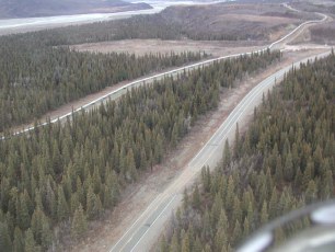
Photo Courtesy of Peter Haeussler
U.S. Geological Survey
In Mandeville, across Lake Pontchartrain from New Orleans - more than 3,018 miles from the quake boats were seen bounce around from the deck of a house.
It is felt that the M6.7 quake of Oct. 23, 2002 may have been a foreshock to the M7.9 quake. It is located about 50 miles east of the Oct. 23 2002 quake The McKinley Park M7.9 quake occurred at the east end of the aftershock zone of the Nenana Mountain M6.7. The Nenana Mountain M 6.7 shock was the largest earthquake on the Denali fault since 1932 when three magnitude 6.0, 6.9 and 6.0 shocks occurred within a 5-month time period. The 1932 events were located at the western end of the Denali fault (lat 62.5N and longitudes ranging from 152.5W to 153.3W). The largest recorded event that can be attributed to the Denali fault was in 1912, when a M 7.2 earthquake occurred more than 50 miles to the east of the October 23 temblor. Since there were no seismographs operating in Alaska at that time and no reports of surface faulting in the remote Alaska Range, the location of the 1912 shock is not well constrained.
Contributed By - Don Eck
For The Seismic Safety Zone
| home | Hazard Awareness | Don's Corner | Feature Of The Month - Loma Prieta Quake | Fault Of The Month | Useful Links | Earthquake Prediction | Home Retrofitting | Earthquake Insurance | Poem Of The Month | Field Trip Story | Professional Insurance Services