|
 >>> >>>
FOCUS ON:
PANAMA CANAL TREATY
TRANSITION.... 1979-1999
Summary of Treaty
Transition Milestones
Military Property
Transfers to Panama
Treaty Impact on Military
|
U.S.
MILITARY PROPERTY TRANSFERS TO PANAMA
(October
1979 - December 1999)
(part of
Panama Canal Treaty Implementation)
OVERVIEW
 | Total of 95,293 acres (with 5,237
buildings and other facilities mostly on 12 major active military
bases) transferred to the Government of Panama over the 20-year
transition period Oct 1979 - Dec 1999 |
| All together worth over $4 billion
dollars (conservative estimate) |
| Transferred to Panama at no cost as
stipulated by the Panama Canal Treaty |
RATE OF
MILITARY PROPERTY TRANSFERS TO PANAMA
(October 1979 -
December 1999)
|
YEAR |
STRUCTURES |
ACRES-LAND |
|
1979-1994 |
614 |
17,019 |
|
1995 |
693 |
5,000 |
|
1996 |
283 |
5,897 |
|
1997 |
549 |
1,691 |
|
1998 |
108 |
49 #
|
|
1999 |
2,990 |
65,637 |
|
TOTAL |
5,237 |
95,293 |
PANAMA
CANAL AREA TREATY MAP

| PANAMA CANAL
AREA TREATY MAP --This map
(similar to the one among the Attachments to Annex A to the
Agreement in Implementation of Articles III and IV of the Panama
Canal Treaty of 1977). Popularly called "the Treaty map,"
it denotes the major U.S. military installations and facilities
(brown for Defense Sites and green for Military Areas of
Coordination) and the principal Panama Canal Commission facilities
(red for Panama Canal Commission housing areas and pink for
Panama Canal Operating Area), as defined by Treaty. One can
appreciate what remained under United States control after October
1, 1979, when the former Canal Zone (shown in white) was abolished
with the implementation of the Panama Canal Treaty. [Source: U.S.
Southern Command Directorate of Treaty Implementation] . |
|
The following pages of this
section provides summary information on
all the U.S. military properties in Panama transferred to the government of
Panama under the Panama Canal Treaty of 1977 from Treaty Day (October 1,
1979) to the last days of the 20-year transition (noon on December 31,
1999). In addition to some history, the individual entries of this section also
briefly note how the transferred properties are being used by Panama. Such information (drawn from Panamanian and U.S.
government sources and local news media reporting over time) is not yet
complete since full conversion of many of the bases or facilities
transferred is still on-going. Therefore, this section will be updated
periodically as appropriate.
These summary descriptions, in this section, of
transferred properties are amplified for each military base (which
includes its history; what transferred, and how Panama is using it today)
with appropriate links for navigation to them.
The following list (19 pages) is in chronological
sequence by date of transfer of the bases and other military properties.
To quickly access a particular base,
facility or other property, use the summary chart of all the
transferred properties (in alphabetical sequence) in the previous section
for easy navigation to related information in this section.
|
|
INDIVIDUAL MILITARY PROPERTY TRANSFERS
(October 1, 1979 - December 22, 1999)
|
| DATE |
PROPERTY
|
| 1979/
Oct 1
|
FORT
AMADOR -
part of Army sector (at
the Pacific entrance to the Panama Canal) --
|
17 buildings (which housed the Army headquarters staff --
primarily in Bldg.1 -- and staff/units in Buildings 2-9, 45-47) and |
| eight
family housing units (the three sets of duplexes between the
Army Officers Club and beginning of the Causeway and two
framed houses on the Bay side of Amador) |
|

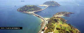
Fort Amador -
Army Sector -- The part transferred to Panama Oct. 1,
1979. Building 1 (former Army headquarters) in center foreground, row of former
barracks/units/ administrative offices on right, and some
buildings in left background. Causeway and
islands (Naos, Culebra, Perico, and Flamenco) in far
background. [U.S. Army Photo, 1978]
|
USE
BY PANAMA:
|
All the above
transferred buildings were used by Panamanian military
(primarily by the Panamanian military police company, the
Fifth Rifle Company, created in July 1978);
Building 1 housed the Panamanian military's Canal Security
Command element Oct 1979 - Dec 20, 1989. |
| In 1993,
President Endara, by executive order, decreed that Amador and
the four islands would be developed into a major tourist
complex beginning after the transfer to Panama of the remainder of Fort
Amador (transferred in August 1996.) |
|
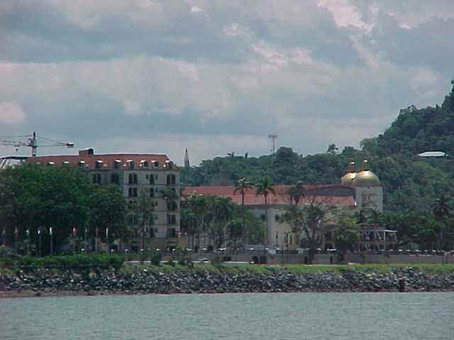
After the
Panamanian military was abolished by the Panamanian government
following the U.S. invasion December 20, 1989,
Building 1 temporarily housed the Panamanian Foreign Ministry
1994-1998 which then moved to Quarry Heights as another
temporary move. Building 1 was demolished toward the end
of 2004. Most of
the other transferred buildings in above photo were demolished
by 2000 and a pedestrian and
cyclists pathway was constructed all the way to the islands via the causeway. |
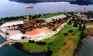
PANAMA
CANAL VILLAGE, in left and center parts of photo,
under construction since 2002. White areas in
background are concrete parking lots for public. New
divided road, in foreground, is access from front of
Amador to Causeway and Flamenco Island. [Photo
courtesy of ARI from its website]
|
Above
photo--Initial part of Panama canal Village (on
left side and center of aerial photo -- the white
parking lot) with the first of several 6-floor buildings
on site of former Army general's residence. [Photo
by WHO June 2003]
|
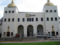
FIGALI
CONVENTION CENTER, part of Panama Canal Village,
constructed in mid 2003, hosted the Miss Universe pageant
at Amador June 3, 2003, part of Panama's centennial
celebrations. [Photo from Estrella de Panama,
June 2003]
|
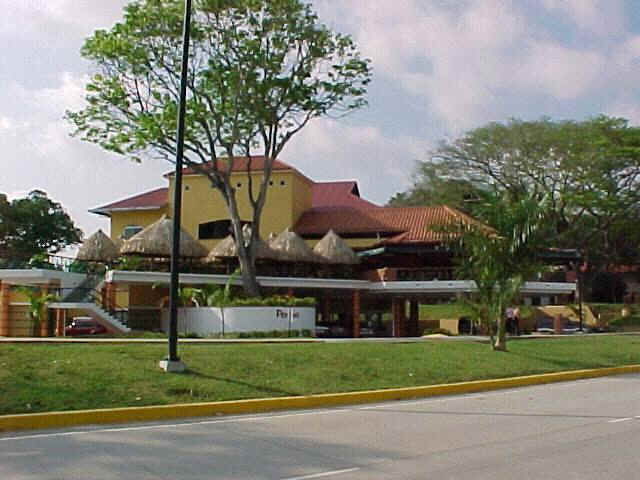
PENCAS
RESTAURANT, located between the former Amador Officers
Club and the new Panama Canal Village, was constructed in
2001-2002 overlooking the bay of Panama. [Photo
by WHO, June 2002]
|
For details on
projects completed and underway at Amador go to Amador-New
Uses .
|
Army
Property
Amador-Army-
History
Amador-
New Use |
| 1979/
Oct 1 |
Former
Fort Grant (islands of Naos, Culebra, Perico, and
Flamenco)
The four
islands of former Fort Grant--Naos
(in foreground), Culebra or Scout island (to the right
beyond Naos), Perico (upper left background), and Flamenco
(the last island connected by the causeway that also
connects the islands to Fort Amador. [Photo
courtesy of ARI website; used with permission]
|
These
islands (particularly Flamenco Island) were the most heavily fortified part of the world with
various types of heavy Coast Artillery weapons during World I through
World War II as a major part of the defense of the Panama
Canal. All such weapons were withdrawn from Panama shortly
after the end of World War II. USE
BY PANAMA:
|
Tourist facilities
and attractions have been established on these islands as part
of converting Fort Amador and the islands into a major tourist
complex as decreed by the Panamanian government in 1993. |
|
Shopping mall with
boutiques, restaurants, nightclubs, a duty free store for
passengers desembarking cruise ships at Flamenco, and other
attractions, along with a yacht port, now are located on
Flamenco Island (the furthest island in above photo). |
|
Hotel under constructed at Perico Island (second furthest island in photo)
and other marine attractions for tourists now located on Naos
and Culebra Islands. |
|
The 2-mile
causeway now has a wide pedestrian walkway with path for cyclists and
skaters. |
For details on
projects completed and underway on the islands go to New
Use links
for the four islands shown in the right column. |
Army Property
Fort Grant-
History
Flamenco-
New
Use
Noas-
New
Use
Culebra-Scout-
New
Use
Perico-
New
Use
|
| 1979/
Oct 1 |
Albrook
Army Airfield (across airfield from Albrook Air Force
Station and adjacent to the Panama Air Depot (PAD
Area) on Pacific side)
| Complex of four hangars, plus 210th
Army Aviation headquarters building |
| 6,850-foot airstrip and associated
taxiways
| Also nearby building 1025 last used as a
shopette |
|

Albrook Army
Airfield and Panama Air Depot (PAD) Area -- townsite and port of
Balboa and Bridge of the Americas in far background. [U.S. Army Photo,
1978]
|
USE BY
PANAMA
| Two of the three hangars were
used by the Panama Defense Forces Engineer battalion through
1989. |
| The largest hangar (right center
of above photo) was and is used by the Ministry of Public Works. |
|
Army
Property
Albrook-
History
Albrook-
New Use
PAD
Area-
History
PAD
Area-
New Use
|
| 1979/
Oct 1 |
Curundu
Heights family housing (located near former Albrook Army
Airfield)
| 20 housing units.
|
USE BY PANAMA:
Panamanian family housing
|
Army
Property
|
| 1979/
Oct 1 |
Quarry
Heights family housing -- Two
housing units on Morgan Avenue below Quarry Heights (near Balboa
Elementary School). |
Army
Property |
| 1979/
Oct 1 |
Portion of
Fort Clayton
land including Friendship Highway and Curundu Road
(from
what is now the North Corridor toll road to the backside of Fort
Clayton and Albrook Air Force Station and to the former PAD Area).
The back limit on the two-lane Friendship Highway, constructed in
1974, was the Military Police gate at what is now the middle part of
the overpass over
the North Corridor toll expressway near Chase Heights housing area.)
USE BY PANAMA:
| The SOS children's village (for
orphaned children), near the site of the former Military Police
gate, was constructed in the early 1980s. Shortly thereafter, a
handicapped children rehabilitation center was constructed nearby on
the same side of the road. |
| A Chinese school was established nearby
on the same side of the road in the
late 1980s, followed by inauguration of the Chinese-Panamanian
Friendship Park in 1997 across the road (Friendship Highway) from
the Chinese school. |
| A new Judicial City (which
consolidated into one area several agencies of the Judicial
branch of the Panamanian government) was constructed early 2000s
across the road from the handicapped children rehabilitation
center. |
| In 2003-2004 a small gated residential
community Camino de Cruces was constructed across the road
(Friendship Highway) from the
SOS children's village. Prices of the houses begin at
$250,000. |
|
Army
Property
ChinesesPanamanian Friendship Park
Camino
de Cruces residential area
|
| 1979/
Oct 1 |
Part
of Quarry Heights and top of Ancon Hill -- vacant area
from the 4th of July Avenue (Avenue of the Martyrs) up to the back
gate to Quarry Heights, with the relocation of the original back
gate next to the Avenue.
USE BY PANAMA:
| Panamanian government erected an
enormous flagstaff and support base on top of Ancon Hill in
mid-1979 for flying (day and night) the huge Panamanian flag beginning
October 1, 1979.
| Panamanian government declared
part of Ancon Hill a protected forest/nature preserve to protect
the varied wildlife there.
| Mi Pueblito
model of interior
village (at the location of the original back gate to Quarry
Heights) was constructed beginning in the mid-1990s spearheaded by then
Panama City Mayor Mayin Correa, followed by two other model villages
in the same area depicting the Antillean and native Indian
cultures in Panama, also spearheaded by Correa. |
| |
Mi Pueblito, model
of typical Panamanian villages in the interior parts of
Panama, on part of former Quarry Heights transferred to
Panama October 1, 1979 [Photo by WHO 2002]
|
| This
page last updated: |
Sept.
21, 2007 |
 |
| Site
developed, owned and maintained by |
|
William
H. Ormsbee, Jr.
2005-2007 |
|
Army
Property
Quarry
Heights
History
Quarry Heights
New
Use
|
|