 Full Moon's and Celestial Spirit's
 Please note that the following is still under construction(and probably always will be!). I've provided a table of contents
and links back to the table at the end of each section, in case you only want
to read certain sections. I have added our Trail Journal, if you care to read a day by day detailed accounting of our hike. Let me know what you think - what you would like to see different, etc. If you are planning a thru-hike and have any
questions, please feel free to email us at
mholmes@netva.com or
jholmes@netva.com
Please note that the following is still under construction(and probably always will be!). I've provided a table of contents
and links back to the table at the end of each section, in case you only want
to read certain sections. I have added our Trail Journal, if you care to read a day by day detailed accounting of our hike. Let me know what you think - what you would like to see different, etc. If you are planning a thru-hike and have any
questions, please feel free to email us at
mholmes@netva.com or
jholmes@netva.com
| Back to Home/Personal Page | Cooking Page | AT Photo Page | Janet's Art Page | Guestbook |
 Our Trail Journal - including Mileages, Mail Drops, and Pictures! Our Trail Journal - including Mileages, Mail Drops, and Pictures! |
|||||||
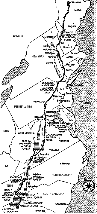
The AT - all 2159 miles of it! (Use your right mouse button to click on the image and view at a larger size)

Five million steps are required to walk the AT from Georgia to Maine, assuming you have a 27 inch stride on average, which is about right for someone 5'6" in height. If you are six feet tall, the trip can be done in only 4,583,000 steps (from Wingfoot's The Thru-hiker's Handbook)Back to Table of ContentsEach mile of the AT has an average elevation gain of 217 feet, which means that a thru-hiker will climb and descend a total of 88.3 miles between Springer and Katahdin. This is the equivalent of going from sea level to the summit of Mt. Everest and back more than sixteen times! (from Wingfoot's The Thru-hiker's Handbook)
At the time though, we really didn't
think that was going to happen. However, in January of '95 we took another
look at our lives and said why the heck not?? We decided that you only go
around once in this lifetime and
to always do "what is expected" was not something that appealed to us. Janet
felt even a stronger pull, as her mother had passed away in her 40's
from cancer, which drove home the realization that there are no guarantees
in life.
Thus, with only 3 months to prepare, we made our decision and then boy did
we have our work cut out for us! What made this whole venture even more
exciting,was the fact that we had never backpacked in our lives. So for
the next few months,while trying to do our jobs, we were simultaneously busy
reading, on the computer researching, or attending
backpacking seminars at REI in Atlanta.
As we found out,
it wasn't quite as easy as that. Having seen only parts of the AT in the
Shenandoahs we had no idea what sort of terrain we would really be climbing
over. As it turned out the section of the AT we had walked on in the
Shendandoah's during our car camping trip turned out by far to be the
easiest terrain on the entire trail (figures,huh?). On the other hand
Georgia and North Carolina were really
tough as you ascended steeply (Kelly's Knob-ah,thought you could beat us,
huh?) and then descended rapidly!. We were lucky to
hike 1 mph uphill and maybe 2 mph downhill, since to hike faster downhill
meant more agony on the knees and a greater chance of falling (something
we did quite a bit of anyway!)
I should also note here, that we were 45 and
40 respectively when we started and totally out of shape. And it probably didn't help that in April of '95,
it was already in the 90's (that will be hard for those in '96 to believe!)
Further increasing the challenge was the
fact that we never even tried out our backpacks till the day we hit the trail.
Heck, we were trying to cram things in them at 11 p.m. the night before our
hike!
If I were going to offer any advice, I would suggest that you take
a tad bit longer than 3 months to prepare for this adventure or you may
be readjusting your goals, as we had to do more than a few times <G>.
In fact, readjusting our goals was the cause for us eventually deciding that
we were not going to make Katahdin by October 15th, so we jumped from
Harpers Ferry to Delaware Water Gap with the intention of hiking that section
southbound as soon as we finished Katahdin. Well, that plan would have
worked, except that I broke my ankle coming across a wet, grassy slope just
south of Woodstock,Vermont near Rt. 12. An ankle operation at the Hitchcock
clinic in Hanover, 6 weeks of PT, and another year's worth of rehabbing it
and we are looking forward to trying again in '97!
Usually we would hike about 2 hours before stopping to drop our packs and take
a break. We kept fairly close to that schedule for most of our hike. During
our breaks we would snack on either
trail mix, granola bars, kudo bars, snackwells, oreo cookies, gorp, or a
rare Power Bar (thank God! - make sure you have something to drink if you're
gonna eat these - I think they're akin to D-Con)
These all weighed a
lot, and quite frankly after a while, you could hardly look at the stuff.
Unfortunately, our lunch was often made up of what we did not decide to eat
as a snack in mid morning. This quickly became quite old and we took to
stocking up with bread, peanut butter, bagels, cheese and summer sausage, whenever we went to town. We would take about 1/2 hour for
lunch, sometimes 1 hr depending on how far we had to hike.
We had a Data book
(indispensible) which we studied each day before we headed out which showed
different water sources along the way, road crossings,shelters, campsites,
etc. We would plan our hike around the water sources. The need for water never
left your mind (temps in '95 were smoking hot! Hiking in N.Virginia with a
120 degree heat index) We generally started out each day with 1 1/2
qts. of water each and would replenish again by mid morning, again at lunch,
mid afternoon and then have to stock up again to cook dinner. You always
wanted to carry more water, but it weighs 2 lbs. per qt, so you don't have
that luxury.
Most of the day, Janet and I hiked at our own paces. Since I could climb
hills faster,(Janet is 5'1", I'm 5'9")I would hike on ahead (maybe a 1/8th
of a mile or so) and then periodically stop and wait for Janet to catch up.
This is one of the toughest things for couples to work out. It can be
disheartening if you're the person following and you've just caught up with
the person ahead of you(who has been resting for 5 minutes) and then they
take off as soon as you get there. I followed Janet a few times to get a
taste of my own medicine! ( I should make note here that about the only
argument we ever had as a couple on the trail was when I suggested that
Celestial Spirit could make it across that flooded creek - you guessed it-
she fell in -good thing I didn't have my tape recorder playing that day!)
Most of the day, your head was down watching the rocks. If you try to hike
the AT and look around while you are moving, you are going to be face down
in the dirt in about 5 yards.(The exception to this is when you are slack
packing - for some reason it is easier to look around without 50 lbs on
your back) Often, you find yourself having walked miles without seeing anything
but the rocks on the path ahead of you. You had to
remind yourself to stop and look around and enjoy what you were seeing
(sounds easy, but isn't, especially when you're whipped, sweating like a
dying dog, thirsty,feet screaming, etc)
Whereas at the beginning, we would generally stop hiking around 4-5 p.m.,
as the days grew longer, we found ourselves hiking as late as 7-8 p.m. Those
were 12 hour days and tough on the body. It was a lot nicer if you could hike into
camp around 5 p.m. and have 3-4 hours to get dinner, fetch water, set up
your tent and find some time to just chill out for a while (writing in your
diary, reading a book, talking to friends). Of course, that meant you had
to get up early - something maybe we'll master when we finish our hike
in '97 (but I wouldn't lay good money on it!)
We saw people who carried more and others who carried less.
Some gave up their stove and ate everything cold to save some weight ("Dog" eating Mac and Cheese cold in a Nalgene bottle - yum!) Others gave up sleeping bags, tents
(and often paid for it by freezing their butts off.). The less weight the
better though, no doubt about it. It all depends on what you want out of
the hike. I will say that there were some advantages to carrying 5 pairs
of socks and 3-4 pairs of shorts - it was sure nice to hike in dry clothes.
If I were to do it again, I would cut back some on those items.
Back to Table of Contents
In the week prior to starting the hike, we worked 16 hours
a day, every day, preparing and packing food for all 23 of our scheduled
mail drops, while trying to move all of our belongings into a storage unit
(we lived in an apartment). It damn near killed us and delayed the start
of our hike by two days (April 5th) due to exhaustion.
Most of our drops
were between 5-10 days worth of food. We later learned that carrying more
than about 5 days of food was a killer (we would not exactly frighten
Arnold if you know what I mean) and some of our larger mail drops
we split up as we rec'd them and forwarded them to a new drop up the trail.
Most of the food drops were sent to c/o General Delivery at the Post Office
and marked with "hold for AT Thru-Hiker" with our anticipated due date.
The Post Office would hold these up to 30 days past the due date. We also made use
of hostels,outfitters and others who would hold our parcels as we didn't
have to worry then about post offices closing on Saturdays or holidays.
Janet had
a friend who shipped all of these parcels based on a schedule we gave her.
We also left copies of our schedules with friends and family so that they could
contact us at our mail p/u points if they so wanted to.
Back to Table of Contents
We also
saw wild turkeys, a number of deer, particularly in the Shenandoahs, and
even saw two bears, one of which strolled into our shelter area
at night. He was looking to see if we had hung any
food on the bear poles. After he didn't see any, he started to amble our
way, obviously deciding that we might be tasty morsels. But by that time
on the trail, we were pretty skinny, stinky, and scary looking
so he changed his mind and ambled
back the other direction. (whew!) Those bear pole devices were intended to
keep the bear from
getting to our food - may have worked for bears, but raccoons ran right up
the damn things and almost got our food one night. We hung the food in
the shelter and the little Rascal came right into the shelter. Winged a rock
at him and that finally drove him off.
We did run across many
garter snakes, a few large 5' black snakes, and later in Connecticut, ran
into a
large Timber rattler which crossed directly in front of Janet, hissing and
rattling. That demands your attention! . Along the way, we ran across
box turtles, salamanders, newts (especially after the rain- you couldn't
walk without stepping on them!) and lizards. Lots of birds, but hard to spot.
Carried binoculars at first so that we could bird watch, but you have to
stop too long to look for them, so we sent these back home.
Back to Table of Contents
Mark didn't have
a trail name when we started out from Springer, but on the very first day
of our hike, I was reading a log in the shelter and someone mentioned there
was a half moon out that night. It occurred to me that Mark could be called
Full Moon. I mentioned this to him and he liked it. He later mentioned that
he should have been called "The Big Dipper" for all the water he drank. P.S.
Click here (78K pic) for a picture of our "Brick"on the sidewalk in Damascus - designed by Celestial
Spirit and fired by a very sweet lady in Damascus, Nancy Lamb.
Back to Table of Contents
There were large sections of trail in Virginia called Brushy Mountain and
that was no joke. We would at times hike almost all day through brush up to
our faces and sometimes over our heads with rocks underneath that you could
not see. We really learned to hate the Brushy Mountains of Virginia. And
Virginia was supposed to be the flatter ,easier state of the trial. We found
it to be one of the toughest. It was long, hot, and very wet - once thru
Virginia, we knew nothing was going to stop us unless we broke something (must
have cursed myself!).
Worst of all for us though were the road walks. I
don't know about you, but it literally killed us to walk on the road or any
flat hard section for many miles - nothing pounds your feet worse than that.
I'll take uphills any day - easiest by far on your feet and legs (and good
for your lungs). I should note that much of what I just said may not apply
to those with good feet or who were smart enough to keep their packs under
40 lbs.
Back to Table of Contents
The beginning of the trail played hell on our knees. Fortunately we used two
hiking poles and they were a tremendous help. I seriously doubt if we could
have made it without these. Our knees screamed all night at first - 3 Ibuprofen
were mandatory. It took us a good 3 months before the screaming knee syndrome
subsided. I have bad feet and wear orthotics and my feet hurt so bad after
a 15 mile day, that once I stopped, I could barely walk. It took a good 10 minutes
each morning before I could walk without pain. Fortunately, there were no
long term ill effects. This had been my biggest fear before the hike - that
my feet couldn't make it (my broken ankle doesn't count) Fortunately,
that didn't turn out to be the case. (I am still in the hunt for a good
podiatrist or orthopedic guy who is interested in backpacking and understands
the stresses related to this sport - let me know if you know of one!)
Janet on the other hand had relatively few problems, exept for an occasional
blister and a more serious problem
with her shoulder harness on her pack and of course her knees as well. My advice
if you are starting out on a thru-hike - do a lot of "quad" strenthening exercises.
Back to Table of Contents
Got up late this a.m. - tired out after last 2 days - final 3.9 miles into
Ash Gap were tough. Cold is still bothering me, so didn't really get moving
till after 0700. Had to go way down the trail for water and it was only
a trickle - could only manage a quart. Still we had coffee and cold cereal and at 0950
hit the trail for Roan Mountain. After a .9 mile climb, we stumbled on to
the parking lot at Roan High Bluff. Janet washed her hair in the sink and
I discovered that our water filter had crapped out - grid work was showing through.
fortunately, we had a replacement filter. After about a 1/2 hour break,
we hit the trail again and descended on a very rocky trail all the way down
to Culvers Gap where there were a lot of tourists getting ready to climb
Roan Mountain. Janet and I had been to this parking lot a year ago when we
stayed at Roan Mtn. State Park.
Got a ranger there to take our picture @ the Culver Gap sign and then we
headed up the mountain (Note - on the way down to Culver Gap, noticed a
junco fly out from the bank along the trail - went back to where he flew out and voila! -
4 small eggs - white with rusty spots - just like Wingfoot had said in his
book!) Climbed Roan Mtn. over the balds - beautiful views - took a number of
pictures - thought we were headed towards the very top, but the trail
suddenly swerved to the left and took us thru wet trails and bramble bushes
(blackberries?). Ran into Winged Monkey eating lunch on a ledge about 1/2
mile south of Roan Highlands Shelter. Stopped for about 15 minutes to grab
some eats,
but it got cold, so we continued on. Passed another shelter, but didn't
stop - couple of creepy
looking guys there, but they did tell us to take a look at Overmountain Barn.
After a steep climb and a bunch of descents (1.7 miles), we finally reached
the blue blazed trail to the barn. Took a picture of the sign talking about
Revolutionary War soldiers coming thru this gap in the winter. Went on to Barn - breathtaking
views looking thru the valley - not to be missed!. Ran into Cathy who was hiking Southbound. Stayed there for
30 minutes and around 4:30 p.m. decided to hike the next 2.1 miles to Bradley
Gap. Tough climb from Barn with the sun burning a hole in us, but views were
great. Saw a
vulture or hawk perched in a tree and watched it ride the thermals out over
the valley.
Climbed Little Hump Mtn. with fabulous views of the mountains - large rock
formation near the top. Descended into gap short distance and found grassy
area to camp. Fortunately Cathy had told us there was water further down
the trail or we would never have found it
Made a fire, ate Red beans and Rice, wrote in our journals. During the night
visited by a very large dog - looked like a cross between a St. Bernard and
an elephant! Was eating something in the brush near our tent - just stared
at us, when we shined our light on it. Wierd to see this big dog out here.Glad
he was more interested in what he was foraging for in the brush than us.
Last night it rained and the wind blew fiercely. It almost caused our
tent to collapse, it was so strong. This a.m. everything was wet and muddy and
it was still raining,too! What a mess. We got up around 7 a.m., had
cereal and started to reorganize. We decided to hike on to Tray
Mountain Shelter even though it would be a long day. It was raining and
misty for most of the day.
When we got to Unicoi Gap we saw "Primal Tang"
and "Terrapin" hitching a ride into Helen. We stopped there for a snack,
then we
headed up (after all, it did say Gap,didn't it?) - what a climb! But it
started to clear and turned
out to be a great hiking day.
Around 3 p.m., we came to Indian Grave Gap and
there was a guy in his truck which made me a little apprehensive, since I came
down the trail first. But he was handing out bananas,oranges and sodas. What
a blessing! We were going to stop here for a snack anyway. He was from
Roswell, GA and worked for Publix Grocery Stores. He came out on his day
off and handed out food to hikers. What a great guy - Mark Lenick. Will
have to go visit him at the end of our hike - Publix #456. We thanked him
profusely. I ate two bananas and drank a root beer in record time. We took
some
along for the trail,then stopped to eat an orange by the old cheese factory
site.
The climb to Tray Mt. wasn't as bad as projected. It had a lot of
switchbacks unlike Unicoi Gap which was straight up and down. There were
great views from the top of Tray Mtn. We stopped to take a few photos. We
got to the shelter and decided to sleep here because our tent was still wet.
We washed out a few clothes and dried out the tent and ground covers. Sleeping
in the shelter with the mice should be a new experience. They even have a
privy here. May need to use it in the a.m. We will shoot for the
Blueberry Patch tomorrow, some 10 1/2 miles away. We saw "Lima Bean" here
as well as "Graybeard" and "Diesel". Well, good night and sleep tight, hope the mice don't
bite!What compelled you to quit your jobs and hike 2159 miles in 6 months?
While on a car camping trip in in the fall of '94 along the Blue Ridge Parkway
and the skyline drive in Virginia's Shenandoah National Park, we had the
opportunity to hike small sections of the trail. We reflected at the time
on how it would be neat to just blow off our jobs and go out and do
something we could be excited about. (That's what happens when
you go to college in the late 60's)
Back to Table of Contents
What Goals did you set for yourself?
I spent a long time pouring over Wingfoot's Workbook for Planning a Thru Hike
(written by Dan Bruce of Hot Springs,NC - Dan has hiked the trail 7 times and has an outstanding
web site on the Thru-Hiking community).
We used his
Workbook in planning our AT thru-hike. We hoped to be able to start off
hiking 6-10 miles a day and after a month or so, be up to hiking between
12-15 miles per day and eventually 15-20 miles per day.
Back to Table of Contents
Describe a Typical Day
A typical day meant getting up between 6 and 7 a.m., heading for
the nearest water source (usually but not always! within a 100 yards
of the shelter or campsite)to filter some water for coffee and cooking and
then firing up the our Coleman Apex II white gas stove. We would drop some
Folgers single coffee bags (not bad tasting actually) into our Nalgene
bottles (get the smoked gray hard plastic ones - they don't trap tastes)
to make some coffee and then down some instant oatmeal or some cream of wheat.
Some mornings we would eat Cheerios or Raisin Bran (or Dust Bran after
being in our packs for a while), other mornings those juicy Pop Tarts
(get the ones with icing on them!). Never really learned to drink a quart
of water before starting out,like you're supposed to. Some mornings we
would even have a bagel w/ cream cheese - now is that living, or what?
Back to Table of Contents
What sort of weight did you carry?
We started with 53 lbs and 42 lbs. We tried everyway we could to get
this lower and maybe by the end of the trail we were down to 45 and 38,
if we were lucky. I was carrying 4-5 lbs. of camera gear which made it tough,
yet resulted in some 1000 slides of the trail ( and Janet was quick to remind me
of the weight saving she would realize if I would chuck the camera and carry some
of her weight!)
How did you get your food on the trail?
We had purchased all of our food ahead of time, much of it at Sam's
Wholesale Club. A lot of Lipton Noodles, Ramen Noodles, Hamburger Helper
Meals, and dehydrated peas,carrots,clams,shrimp,chicken,salmon,tuna that we
had done ourselves. (Clams dehydrated are particularly tasty!). During
our hike, we would just drop the dehydrated stuff in an empty Nalgene
bottle a couple hours away from our destination, add some water, and by
the time we got to camp, voila! - it was ready.
What sort of wildlife did you encounter?
Surprisingly, we saw relatively little wildlife. Part of this was due to
a theory we had that our hiking poles could be heard on the rocks and caused
vibrations in the ground, thus scaring off game before we saw it. However,
we did run into many grouse on the trail, and these little suckers
loved to take off out of the
brush with a helicopter type roar and scare the hell out of you.
How did you pick your Trail names?
Janet My trail name is Celestial Spirit. As an artist, I use
stars, moons and suns in my work. I wanted to use them in my trail name
but I couldn't find a good combination. So I thought that Celestial
covered them all, but I still needed something
else, so I chose Spirit, for the creative side of my personality ,
but also for the spirit in which we intended to hike the AT.
Describe the Trail Conditions
Well, I've already mentioned all the rocks. We had lots of steep climbs,
sometimes while climbing rock faces, we had to hold onto tree branches,
roots or whatever we could get our hands on. There were some areas such as
these, where a fall meant good-bye forever. Albert Mountain was one of these
and we faced others later on in the trail.
Did you lose any weight? What sort of physical problems did you have?
Janet lost 15 lbs and I dropped 32 lbs during our 5 months of hiking.
I think the heat didn't help. I ended up going from a Men's medium hipbelt to
a woman's extra small before I finished.
Our Gear
Note - The following gear items worked well for us. I'm sure there are many
other choices that would have worked equally well. To future thru-hikers, I would
only say that the equipment may make it easier, but it most likely isn't going
to determine whether you finish the hike or not. That lies in your heart and mind.
(Full Moon divulges ancient wisdom).
We were well satisfied with our gear. Not much we would change - perhaps
carry a bit less (like about 30 lbs!) . I would maybe drop the camera gear (4+lbs) and take a 2 lb.
video camera.
Back to Table of Contents
Favorite Spots/Happenings/People on The Trail
Back to Table of Contents
Excerpts from our Trail Diaries
Mark (aka "Full Moon")
Sunday May 21, 1995 Ash Gap to Bradley Gap Campsite (9.9 miles)
Janet
April 12th Blue Mountain Shelter to Tray Mountain Shelter 7.7 miles
Back to Table of Contents