|
ARDEE CASTLE
Map Reference: N962907
This large tower-house is almost rectangular in plan with westward projecting turrets at the NW and SW angles. It is four
storeys high and the turrets rise for another storey above the roof level. There is a vault over the ground floor. The area
between the turrets has been filled by a modern addition. Part of this addition houses a flighted stairway leading to the
first floor. A smaller flighted stairway within the SW turret leads to the second and third floors. There is also a spiral
stairway within the NW turret which leads from the ground floor to the roof. The original doorway is in the N wall close to
the NW angle. It was protected by a murder-hole and a machicolation at roof level. The castle is known locally as The Courthouse.

HATCH'S CASTLE, ARDEE
Map Reference: N962905
This small four-storey tower-house is rectangular with rounded corners. There is a smll eastward bulge at the NE corner and
a round projecting turret at the SE corner. The original entrance was near the E corner of the S wall. The turret at the SE
corner houses a spiral srairway which rises to roof level. There were garderobes at the first and second floor levels in the
NE corner. There is a vault above the ground floor and the present entrance is through the W wall. The castle is still lived
in and ther is little evidence of the original doorways and windows.

CARLINGFORD DOMINICAN PRIORY
Map Reference: J190114
This priory is thought to have been founded by Richard de Burgh in 1305. The remains consist of a nave and chancel church
divided by a tower with some fragments of the domestic range to the south. There is evidence of a large E window but all remains
of tracery are removed and there is no evidence of the original number of lights. The nave was altered in later times when
crenellations were added to the W wall and small turrets were placed at the NW and SW corners. There is a machicolation guarding
the W doorway.

KING JOHN'S CASTLE, CARLINGFORD
Map Reference: J188120
King John is supposed to have stayed in this castle for three days in 1210. It was probably built a few years earlier by Hugh
de Lacy. The earliest part is the D-shaped curtain wall in the W. This had a rectangular gatehouse ansd a square SW flanking
tower. Portions of the N tower of the gatehouse still remain. The curtain wall is well provoded with deep embrasures with
narrow defensive slits. During the second half of the 13th century a large rectangular hall was added on the E side. This
is three storeys high including the basement. The castle stands on a rocky outcrop overlooking the harbour. During the 19th
century the Dundalk, Newry & Greenore Railway constructed a deep cutting on the landward side thereby enhancing the prominent
position of the castle.

TAFFE'S CASTLE, CARLINGFORD
Map Reference: J189117
This rectangular tower-house is four storeys high plus the roof walk. It has a projecting turret at the SW corner. The original
entrance was in the W wall beside the turret. It was protected by a small machicolation. To the left of the entrance a short
passage led to a spiral stairway in the NW corner. This led to the second floor and was protected by a murder-hole. Another
spiral stairway in the SW corner led from the second floor to the roof. There are garderobes at three levels in the NE corner.
The tower is vaulted above the first floor. This part of the castle was built in the early 16th century. Later in that century
a two-storey rectangular addition was built against the N wall.

THE MINT, CARLINGFORD
Map Reference: J189116
This small three-storey tower-house is said to be the site of a mint established in 1467. The doorway is in the NE wall near
the E corner. It has been partly reconstructed with some finely decorated stones. It is protected by a large machicolation
at roof level. There are also fine crenellations. The absence of any fireplace suggests that the castle may not have been
used as a dwelling and the strength of the defences reinforces the idea that it may have been a mint. There are some fine
windows in the NE wall with hood moulds and mullions. They are richly decorated with pre-Norman motifs such as interlacing
and animal and human heads.

CASTLETOWN CASTLE
Map Reference: J032087
This is one of the larger tower-houses in the region. It is a four-storey rectangular building with large rectangular flanking
towers at the E and W corners and smaller towers at the N and S corners. It is vaulted above the first floor level. The flanking
towers rise for another storey above the roof walk. The entrance in the Se wall is protected by a murder-hole. A spiral stairway
rises to roof level within the S flanking tower. Some corbel stones at the top of the SE wall may be the remains of a machicolation.
The castle was built about 1472 by Richard Bellew and may have had a surrounding bawn. There is now no trace of this.

ST LAURENCE'S GATE, DROGHEDA
Map Reference: O092753
This is one of the two remaining gateways of Drogheda. It is a barbican with an arched entrance flanked by round towers on
the N and S. The towers are four storeys high plus the crenellated parapet. Curved mural stairways rise to the first floor
in both towers and broad modern stairways give access to the second floor. A smaller spiral stairway connects the second floor
of the S tower to the roof. The building has many long narrow defensive slits. Nearby, to the S, is a good portion of the
town wall.

DUNMAHON CASTLE
Map Reference: J036021
Dunmahon Castle is a four-storey tower-house with projecting towers at the NE and NW corners. It is vaulted above the ground
floor. The entrance in the N wall is protected by a murder-hole. A short passage to the left of the entrance leads to a spiral
stairway which rises within the NE flanker. The NW flanker house garderobes. The castle was probably built in the 15th century
and was inhabited until the end of the 17th century. It is now in very poor condition.

MELLIFONT CISTERCIAN ABBEY
Map Reference: O013780
Mellifont Cistercian Abbey was founded in 1142 by monks from Clairvaux who were invited to Ireland by St Malachy of Armagh.
Building was commenced in 1157 and completed by about 1225. The layout is typical of Cistercian abbeys with a large cruciform
church to the north of the cloister. There were three E chapels in the transepts. The most notable feature of the cloister
is the octagonal lavabo which projects into the cloister garth from the S range. The abbey was burned early in the 14th century
and parts of the nave were then rebuilt. A tower was built in the 15th century. The ruins today are mostly reduced to foundation
level. The vaulted chapter house is the only roofed building remaining. It dates from the early 13th century.

MILLTOWN CASTLE
Map Reference: O034993
This four-storey rectangular tower-house has round projecting towers at the E and W corners. These towers rise one storey
above the roof of the main tower. The castle is vaulted above the ground floor. The original entrance in the SE wall was protected
by a murder-hole. The present entrance is through the base of the E flanker. This leads to a modern flighted stairway which
rises within the flanker to the second floor. This then changes to the original stone spiral stairway which rises to roof
level. There are very fine crenellations. The castle dates from the 15th/16th century and was lived in until modern times.

MONASTERBOICE MONASTIC SITE
Map Reference: O043821
The monastery at Monasterboice was reputedly founded by St Buite who died in 521. The remains include two churches, a Round
Tower, three High Crosses and a sundial. The best preserved structure is the South Cross. This is also known as Muiredach's
Cross because of an inscripton on the base. A date of 922 has been accepted for this cross because of the death of the abbot
Muiredach Mac Domhnail at that date. The cross is 5.5m high and is richly decorated with Biblical scenes including the Fall
of Man and Cain & Abel. The style of decoration and some of the subjects, particularly the non-biblical motifs, suggests
that the designer of this cross may have been responsible for the Market Cross, Kells, the Durrow Abbey cross and the Cross
of the Scriptures, Clonmacnois. A short distance to the NW is the South Church, a simple rectangular 15th century building.
The North Church is a similar building and lies a further short distance to the NW. Just outside the S wall of this church
is the West Cross. This is about 7m high. This has similar carving to the South Cross but is is less well preserved. The lower
part of the shaft, in particular, has been badly damaged. Close to the W gable of the North Church is the Round Tower. The
top is damaged but the tower stands to about 30.5m. It has a Romanesque doorway on the E side about 2m above the present ground
level. The doorway is framed by two slightly raised parallel bands. It was burned in 1097 with its library and treasures.
Near the eastern boundary of the graveyard, within a railed enclosure, is the North Cross. This is the upper portion of a
ring-headed cross with a Crucifixion on the W side and an interlaced roundel on the E side. Beside it is a pillar stone with
a medieval sundial.

PROLEEK DOLMEN
Map Reference: J082110
This portal tomb has a massive capstone resting on two portal stone and a side stone. The capstone measures 3.8m by 3.2m and
is estimated to weigh about 40 tonnes. The portal stones are about 2.3m high. The sidestone is buttressed by a modern stone
and concrete support. The small stones on top of the capstone are due to a legend that a wish will be granted to anyone who
throws a pebble on top of the capstone so that it stays there. Another legend says that anyone who walks three times round
the dolmen will be married within a year.

PROLEEK WEDGE TOMB
Map Reference: J083110
This wedge tomb has a 6m long gallery 1.5m wide at the front and 1m wide at the back. It is closed by a single stone at the
W and there is one facade stone beside this. There is a single roof lintel in place near the E end. There is no trace of an
outer wall or cairn.

ROCHE CASTLE
Map Reference: H991119
This large castle is said to have been built in 1236 by Lady Rohesis de Verdun. However the remains appear to be of a later
date and were probably built by her son John who died in 1274. The castle was ruinous by 1464 when Richard Bellew obtained
a grant to repair it. The castle sits on top of a rocky outcrop and has a substantial irregular four-sided curtain wall. The
twin-towered gatehouse near the S end of the long E wall is protected by a rock-cut ditch. The towers of the gatehouse are
four storeys high, with vaults over the ground floor level. They were originally D-shaped bu only the curved outer walls,
with attached fragments, remain. The D-shaped flanking tower at the N corner was probably three storeys high. Just inside
the gatehouse, on the left, is the ruin of a large rectangular hall. There are traces of later buildings throughout the ward.

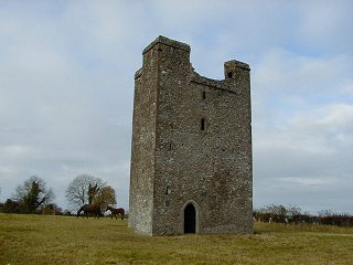
ROODSTOWN CASTLE
Map Reference: N996925
Roodstown Castle is four storeys high with projecting towers at the NW and SE corners. The entrance is in the E wall beside
the SE flanker. It is protected by a murder-hole. A spiral stairway rises within the SE tower to roof level. The NW tower
contains garderobes. At the first floor level there are windows in the N, S and W walls. Those in the N and S have two lights
with ogee heads. The W window has a single light with ogee head. The S window has a transom. The castle dates from the 15th
century.
TERMONFECKIN CASTLE
Map Reference: O143803
Termonfeckin Castle dates from the 15th/16th century. It is a rectangular three-storey building with the entrance in the NW
wall. A fragment of a 17th century bawn protects the doorway. A spiral stairway in the NE corner rises to roof level. There
are two chambers at the ground floor. The larger chamber is covered by a barrel vault. There are garderobes at the first and
second floors in the S corner. The width of the castle contracts sharply above the first floor so that the s corner now appears
as a projecting tower. At the second floor there is one large room and the garderobe. It is covered by a very fine corbelled
vault.

TERMONFECKIN HIGH CROSS
Map Reference: O141804
A monastery was founded here in 665 by St Fechin of Fore. The High Cross is the most noticeable remnant of an ealy foundation.
It is a ring-headed sandstone cross with a church shaped finial and a plain hemispherical base. The E face has a crucifixion
surmounted by a winged figure and the W face has Christ in Glory. All faces of the shaft feature panels of interlacing and
spiral ornament. The base is probably of fairly recent origin. A short distance to the E of the cross is a small granite base
of another cross. It tapers from a rectangular base to a circular top. Each side has a plain open panel framed by a double
line in relief. Between this cross base and the High Cross is a small sandstone crucifixion slab.

|